

Hail Map for Friday, April 19, 2019

Number of Impacted Households on 4/19/2019
0
Impacted by 1" or Larger Hail
0
Impacted by 1.75" or Larger Hail
0
Impacted by 2.5" or Larger Hail
Square Miles of Populated Area Impacted on 4/19/2019
0
Impacted by 1" or Larger Hail
0
Impacted by 1.75" or Larger Hail
0
Impacted by 2.5" or Larger Hail

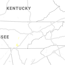
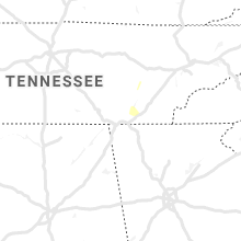
Cities Most Affected by Hail Storms of 4/19/2019
| Hail Size | Demographics of Zip Codes Affected | ||||||
|---|---|---|---|---|---|---|---|
| City | Count | Average | Largest | Pop Density | House Value | Income | Age |
Hail and Wind Damage Spotted on 4/19/2019
Filter by Report Type:Hail ReportsWind Reports
States Impacted
Florida, Georgia, Virginia, North Carolina, South Carolina, West Virginia, Pennsylvania, Maryland, DelawareFlorida
| Local Time | Report Details |
|---|---|
| 8:00 AM EDT | Scattered trees and power lines down in franklin count in franklin county FL, 65.3 miles SW of Tallahassee, FL |
| 8:00 AM EDT | Tree reported down on stone rd near lakeshore driv in leon county FL, 3 miles NNW of Tallahassee, FL |
| 8:11 AM EDT | Report of power line down on sr 2 in liberty county FL, 39.4 miles W of Tallahassee, FL |
| 8:14 AM EDT | Tree down on a home near woodville hw in leon county FL, 7.8 miles SSE of Tallahassee, FL |
| 8:14 AM EDT | Report of a tree down on a home near woodville highwa in leon county FL, 11.3 miles SSE of Tallahassee, FL |
| 8:15 AM EDT | Tree down on capitola road at benjamin chaires roa in leon county FL, 10.2 miles E of Tallahassee, FL |
| 8:54 AM EDT | Tree down on power lines near roberts ave and paul dirac d in leon county FL, 2.4 miles WSW of Tallahassee, FL |
| 8:55 AM EDT | Power lines down across surf road and booth roa in wakulla county FL, 28.5 miles SSW of Tallahassee, FL |
| 9:00 AM EDT | Mping report of trees uprooted or snappe in leon county FL, 2.4 miles NNW of Tallahassee, FL |
| 9:00 AM EDT | Asos station ktlh tallahassee international airpor in leon county FL, 5 miles WSW of Tallahassee, FL |
| 9:00 AM EDT | Tree down on stone road near lakeshore driv in leon county FL, 3 miles NNW of Tallahassee, FL |
| 9:02 AM EDT | Tree down on the side of an apartment building near gadsden and carolina stree in leon county FL, 0.7 miles N of Tallahassee, FL |
| 9:10 AM EDT | Tree over roadway at the intersection of bannerman road and bull headley roa in leon county FL, 10.5 miles N of Tallahassee, FL |
| 9:10 AM EDT | Several trees down in the golden eagle are in leon county FL, 11.4 miles NNE of Tallahassee, FL |
| 9:14 AM EDT | Tree down on ox bow rd at ox bottom r in leon county FL, 7.7 miles N of Tallahassee, FL |
| 9:16 AM EDT | Tree down on oaks edge roa in leon county FL, 6.4 miles ENE of Tallahassee, FL |
| 9:20 AM EDT | Tree down at i-10 at mile marker 201 eastboun in leon county FL, 3.5 miles N of Tallahassee, FL |
| 9:21 AM EDT | Report of tree down on 221 just north of i-10 in madison count in madison county FL, 38.8 miles E of Tallahassee, FL |
| 9:30 AM EDT | Tree down at disston stree in leon county FL, 1.3 miles WSW of Tallahassee, FL |
| 9:30 AM EDT | Tree down at shamrock e at ardara d in leon county FL, 7.3 miles NE of Tallahassee, FL |
| 9:30 AM EDT | Tree down on brewer stree in leon county FL, 1.4 miles WNW of Tallahassee, FL |
| 9:35 AM EDT | Tree down on walden rd at atascadera l in leon county FL, 7.7 miles ENE of Tallahassee, FL |
| 9:35 AM EDT | Tree down on west capps highway and cody church roa in jefferson county FL, 13.3 miles E of Tallahassee, FL |
| 9:50 AM EDT | Hamilton county 911/dispatch reports numerous trees downed across the western portion of the count in hamilton county FL, 64.3 miles SSW of Douglas, GA |
| 10:15 AM EDT | Asos station kcty cross cit in dixie county FL, 90.1 miles SE of Tallahassee, FL |
| 10:20 AM EDT | Suwannee county 911/dispatch reports numerous trees and power lines downed by strong winds county-wid in suwannee county FL, 78.5 miles W of Jacksonville, FL |
| 10:20 AM EDT | A few power lines down in the mayo are in lafayette county FL, 71.1 miles ESE of Tallahassee, FL |
| 10:29 AM EDT | Suwannee county emergency mangement reports a tree downed through a home to the east of live oak. trees and power lines have been reported throughout the count in suwannee county FL, 74.6 miles W of Jacksonville, FL |
| 10:30 AM EDT | Trees down on highway 1 in dixie county FL, 93.3 miles SE of Tallahassee, FL |
| 10:30 AM EDT | Gilchrist county 911/dispatch reports downed trees and powerlines county-wid in gilchrist county FL, 82.2 miles WSW of Jacksonville, FL |
| 10:50 AM EDT | Media reported damage to zaxbys restaurant roof and sign. time estimated by rada in columbia county FL, 62.1 miles W of Jacksonville, FL |
| 10:54 AM EDT | Columbia county em director reports trees and power line down across the eastern portion of the count in columbia county FL, 58.4 miles WSW of Jacksonville, FL |
| 10:55 AM EDT | Fire department reports multiple trees down and on powerlines around the fanning springs are in levy county FL, 91.7 miles SW of Jacksonville, FL |
| 11:00 AM EDT | Fire department reports multiple trees down and on powerlines around the chiefland are in levy county FL, 88.1 miles SW of Jacksonville, FL |
| 11:10 AM EDT | Social media post of a tree downed along northwest 162nd street between newberry and gainesvill in alachua county FL, 68.5 miles SW of Jacksonville, FL |
| 11:30 AM EDT | Baker county emergency management reports numerous trees and powerlines downed throughout the count in baker county FL, 34.1 miles W of Jacksonville, FL |
| 11:30 AM EDT | Storm spotter relayed photos through social media of several trees downed near tower rd and west university ave west of i-7 in alachua county FL, 65.1 miles SW of Jacksonville, FL |
| 11:34 AM EDT | Fdot reports tree blocking left lane of us-19 in gulf hammoc in levy county FL, 95 miles WNW of Orlando, FL |
| 11:35 AM EDT | Fire department reports powerlines down on riverside dr in yankeetow in citrus county FL, 88.2 miles WNW of Orlando, FL |
| 11:35 AM EDT | The baker county sheriffs office reports a tree downed over a home in macclenn in baker county FL, 37.3 miles W of Jacksonville, FL |
| 11:40 AM EDT | Fire department reports tree partially blocking highway 41 just north of willisto in levy county FL, 78.8 miles SW of Jacksonville, FL |
| 11:40 AM EDT | Fire department reports powerlines and poles down on ne 140 ave in willisto in levy county FL, 85.4 miles SW of Jacksonville, FL |
| 11:50 AM EDT | Weatherstem marine science station reported a 50 knot wind gus in citrus county FL, 81.2 miles WNW of Orlando, FL |
| 11:50 AM EDT | University of florida emergency management reports a tree downed near the intersection of museum road and radio road. time of damage based on radar dat in alachua county FL, 63.6 miles SW of Jacksonville, FL |
| 11:50 AM EDT | Fire department relayed photos via social media of numerous trees downed on houses and power lines and blocking roadways in downtown gainesville along nw 34th street ne in alachua county FL, 63 miles SW of Jacksonville, FL |
| 11:53 AM EDT | Trees snapped and hanging on power lines in hilliard along murrhee road. time estimated by rada in nassau county FL, 32.9 miles NNW of Jacksonville, FL |
| 11:54 AM EDT | Bradford county warning point reported that a tree fell on a home in starke. no injuries reported. time is estimated based on radar imager in bradford county FL, 38.7 miles SW of Jacksonville, FL |
| 11:58 AM EDT | Public reported on social media a tree down on a shed in callahan. time estimated by rada in nassau county FL, 18.9 miles NNW of Jacksonville, FL |
| 12:00 PM EDT | Trained spotters reported tree down and large limbs down along crystal springs road near chaffee road. time is estimated based on radar imager in duval county FL, 11.7 miles W of Jacksonville, FL |
| 12:01 PM EDT | Broadcast media relayed a short video on social media of trees down on us-1 in callahan. time estimated by rada in nassau county FL, 18.9 miles NNW of Jacksonville, FL |
| 12:05 PM EDT | Trained spotters reporting trees downed in the dunnellon area...with a tree on a roof in the vicinity of 94th court. time of damage based on radar dat in marion county FL, 74.5 miles WNW of Orlando, FL |
| 12:05 PM EDT | Tree blocking the road near williston in levy county FL, 80.5 miles SW of Jacksonville, FL |
| 12:05 PM EDT | Powerlines down near williston in levy county FL, 87.9 miles NW of Orlando, FL |
| 12:12 PM EDT | Emerency manager relayed a report of a tree downed on a house along west 9th stree in duval county FL, 15.6 miles WSW of Jacksonville, FL |
| 12:14 PM EDT | Emergency manager relayed a report of power lines down from wind along cedar oaks drive. time estimated by rada in duval county FL, 6.2 miles SW of Jacksonville, FL |
| 12:15 PM EDT | Storm spotter relayed a report of a tree down in front of a home at 1721 glendale s in bradford county FL, 37.3 miles SW of Jacksonville, FL |
| 12:20 PM EDT | Sheriff reports trees and powerlines down along bedstrow blvd and oakmont drive in the pine ridge are in citrus county FL, 71.3 miles WNW of Orlando, FL |
| 12:22 PM EDT | Broadcast media relayed a photo on social media of a gate damaged at the heritage on the river apartement complex at confederate point rd. time estimated by rada in duval county FL, 6.6 miles SW of Jacksonville, FL |
| 12:25 PM EDT | Baker county em reported trees fell down on us 90 causing a car to swerve to avoid the downed tree on the roa in baker county FL, 34.1 miles W of Jacksonville, FL |
| 12:25 PM EDT | Broadcast media relayed a report of some roof damage to a home along morgan st. time estimated by rada in duval county FL, 1.6 miles WNW of Jacksonville, FL |
| 12:25 PM EDT | Storm spotter relayed an observation of big tree limbs down on the 6300 block of old middleburg rd near sandler rd. time estimated by rada in duval county FL, 11.6 miles SW of Jacksonville, FL |
| 12:28 PM EDT | Public relayed a photo on social media of a tree down on los robles drive. time estimated by rada in nassau county FL, 22.8 miles NNE of Jacksonville, FL |
| 12:30 PM EDT | Putnam county 911/dispatch reports numerous trees and powerlines downed throughout the northwestern part of the county in putnam county FL, 44.8 miles SSW of Jacksonville, FL |
| 12:30 PM EDT | Emergency manager relayed a report of a tree down on a power line causing a small fir in duval county FL, 13 miles E of Jacksonville, FL |
| 12:35 PM EDT | Emergency manager relayed a report of a tree falling onto a powerline... blocking roa in duval county FL, 8.5 miles S of Jacksonville, FL |
| 12:35 PM EDT | Spotter called in a report of a power line down a block north of his apartment complex near aurura blvd and blanding blvd. spotter also reported numerous tree limbs dow in clay county FL, 11.6 miles SSW of Jacksonville, FL |
| 12:45 PM EDT | The weatherflow station at huguenot park measured a peak wind gust of 60 mp in duval county FL, 15.6 miles ENE of Jacksonville, FL |
| 12:45 PM EDT | Emergency manager reported tree down at the intersection of southeast 90th street and south highway 475 and is blocking traffi in marion county FL, 59.9 miles NW of Orlando, FL |
| 12:48 PM EDT | The florida department of transportation reports that state road 100 east and west bound are closed just west of coral farms road in florahome due to a fallen tre in putnam county FL, 43.5 miles SSW of Jacksonville, FL |
| 12:48 PM EDT | Emergency manager relayed a report of a powerline down on scott mill road. time estimated by rada in duval county FL, 10.5 miles S of Jacksonville, FL |
| 12:50 PM EDT | Storm spotter submitted a photo of a tree down at the intersection of ne 25th ave and ne 3rd st. time estimated by rada in marion county FL, 62.7 miles NW of Orlando, FL |
| 12:55 PM EDT | Broadcast media relayed report of large branch through a roof of a home near 103rd street and blanding blvd. time is estimated based on radar imager in duval county FL, 7.5 miles SW of Jacksonville, FL |
| 12:56 PM EDT | Marion co emergency manager reports a tree down on a private residence near ne 58th ave and ne 35th st. time estimated by rada in marion county FL, 62.2 miles NW of Orlando, FL |
| 1:00 PM EDT | Amateur radio relayed report from clay fire rescue of tree on power lines on shotgun court in middlebur in clay county FL, 25.2 miles SW of Jacksonville, FL |
| 1:03 PM EDT | Storm spotter observed trees down at the intersection of se 3rd st and se 25th av in marion county FL, 62.2 miles NW of Orlando, FL |
| 1:03 PM EDT | Storm spotter observed power lines down at the intersection of se 25th ave and sr4 in marion county FL, 62.7 miles NW of Orlando, FL |
| 1:03 PM EDT | Storm spotter relayed a report with a photo of a large tree down on ne 24th st next to steak n shak near state road 4 in marion county FL, 62.1 miles NW of Orlando, FL |
| 1:10 PM EDT | Media shared picture of a tree that fell on a car at the rogers park golf cours in hillsborough county FL, 37.2 miles NNE of Bradenton, FL |
| 1:15 PM EDT | Florida department of transportation reports a downed tree that is blocking all lanes of traffic on southeast 147th place at southeast 77th court in summerfield. time o in marion county FL, 50.3 miles NW of Orlando, FL |
| 1:15 PM EDT | Media shared picture of a tree that fell on a car at the rogers park golf cours in hillsborough county FL, 37.2 miles NNE of Bradenton, FL |
| 1:18 PM EDT | Trees down near holiday in pasco county FL, 48.8 miles NNW of Bradenton, FL |
| 1:18 PM EDT | Asos at kbkv reported a 54 knot wind gus in hernando county FL, 66 miles W of Orlando, FL |
| 1:19 PM EDT | Tree down near new port richey in pasco county FL, 52.7 miles N of Bradenton, FL |
| 1:50 PM EDT | Powerlines down. road closed at intersection of barcellona road and land o lakes blvd. time estimated by rada in pasco county FL, 53.1 miles N of Bradenton, FL |
| 1:50 PM EDT | Powerlines down at the intersection of sligh avenue and dale mabry hwy. time estimated by rada in hillsborough county FL, 35.7 miles N of Bradenton, FL |
| 1:55 PM EDT | Putnam co em reported that summit st is closed near the usps office in cresecent city due to downed trees and power lines. the usps office sign also sustained some dama in putnam county FL, 61.9 miles N of Orlando, FL |
| 1:58 PM EDT | Davis island yacht club reported a 51 knot wind gus in hillsborough county FL, 29.6 miles NNE of Bradenton, FL |
| 2:04 PM EDT | Fdot reports tree down blocking sb lane of fl turnpike at mm 285 near howey in the hills. time estimated from rada in lake county FL, 26.8 miles WNW of Orlando, FL |
| 2:04 PM EDT | Very large oak limbs down in polk county FL, 45.2 miles SSW of Orlando, FL |
| 2:10 PM EDT | Large tree uprooted. time estimated by rada in hillsborough county FL, 43 miles NNE of Bradenton, FL |
| 2:25 PM EDT | Fallen tree blocking lanes on telfair road. time estimated by rada in hillsborough county FL, 36.8 miles NNE of Bradenton, FL |
| 2:50 PM EDT | Emergency manager relayed a report of tree down on a power line at 37 briarwood rd. time estimated by rada in flagler county FL, 64 miles SSE of Jacksonville, FL |
| 3:04 PM EDT | Lakeland electric reported multiple downed trees and power lines causing power outages in south lakelan in polk county FL, 50.9 miles NE of Bradenton, FL |
| 3:04 PM EDT | Several large trees and power lines reported down in highlands cit in polk county FL, 50.2 miles SW of Orlando, FL |
| 3:10 PM EDT | Storm damage reported in amz572 county FL, 73.4 miles E of Orlando, FL |
| 3:15 PM EDT | Medium to large branches down and small hail near s kings hwy near the airport in st. lucie county FL, 15 miles N of Port Saint Lucie, FL |
| 3:30 PM EDT | Public reports tree down and entangled in utility wires on michigan ave in englewood. road is also blocked due to debri in sarasota county FL, 40.1 miles SSE of Bradenton, FL |
| 5:05 PM EDT | Usaf tower ksc-0506 measures wind gust of 54kt/62mph from sw in brevard county FL, 44.9 miles E of Orlando, FL |
Georgia
| Local Time | Report Details |
|---|---|
| 8:00 AM EDT | A tree was downed onto brown bridge rd at duncan r in banks county GA, 60.7 miles SW of Greenville, SC |
| 8:00 AM EDT | A tree was downed into the roadway at the intersection of beaver creek dr and brown bridge r in banks county GA, 60.7 miles SW of Greenville, SC |
| 8:25 AM EDT | Trees down blocking road in stephens county GA, 40.6 miles SW of Greenville, SC |
| 8:30 AM EDT | A couple of reports of tree branches temporarily blocking roads have since been cleare in mitchell county GA, 54.6 miles N of Tallahassee, FL |
| 8:30 AM EDT | Report of multiple trees down in thomas county outside of thomasvill in thomas county GA, 44.6 miles NNE of Tallahassee, FL |
| 8:44 AM EDT | A tree was downed at the intersection of gauntt road and lower jersey roa in walton county GA, 33 miles E of Atlanta, GA |
| 8:48 AM EDT | Report of tree down on ga hwy 112 and mccarty r in worth county GA, 63.9 miles W of Douglas, GA |
| 8:54 AM EDT | Report of transformer down on fleming and green s in decatur county GA, 36.1 miles NNW of Tallahassee, FL |
| 8:55 AM EDT | Report of a tree down on 112 in worth county GA, 59.1 miles W of Douglas, GA |
| 8:55 AM EDT | Large tree branches were blown onto west highland avenue near west spring stree in walton county GA, 38.8 miles E of Atlanta, GA |
| 9:37 AM EDT | Tree fell on a double wide mobile home in the clyattville are in lowndes county GA, 58.9 miles ENE of Tallahassee, FL |
| 9:45 AM EDT | 10 reports of trees down around lowndes count in lowndes county GA, 51.9 miles SSW of Douglas, GA |
| 9:47 AM EDT | Report of trees down in thomasvill in thomas county GA, 32.9 miles NNE of Tallahassee, FL |
| 10:00 AM EDT | Echols county 911/dispatch reports numerous trees downed in the vicinity of statenville. time of damage based on radar dat in echols county GA, 56.5 miles S of Douglas, GA |
| 10:00 AM EDT | Power line down due to tree breakin in lanier county GA, 34.6 miles SSW of Douglas, GA |
| 10:05 AM EDT | Tree down blocking one lane of traffic on douthit rd just east of hwy 33 in worth county GA, 57.4 miles W of Douglas, GA |
| 10:30 AM EDT | Atkinson county emergency management reports a large tree downed across a roadway in axson. time of damage based on radar dat in atkinson county GA, 17.5 miles SSE of Douglas, GA |
| 10:30 AM EDT | Clinch county emergency management reports trees down in the cogdell area and power outages in dupont. time of tree damage based on radar dat in clinch county GA, 25 miles SSE of Douglas, GA |
| 10:30 AM EDT | Atkinson county emergency management reports trees downed in the vicinity of kirkland. time of damage based on radar dat in atkinson county GA, 13.8 miles SSW of Douglas, GA |
| 10:35 AM EDT | Clinch county emergency management reports damage to the roof of a mobile home near the intersection of u.s. highway 84 and leland smith road. time of damage based on r in clinch county GA, 32.3 miles SSE of Douglas, GA |
| 10:39 AM EDT | Tree down across big creek roa in irwin county GA, 35.4 miles WNW of Douglas, GA |
| 10:45 AM EDT | Atkinson ema reports numerous trees and powerlines down in the northeast portion of the county. same storm as coffee county repor in atkinson county GA, 17 miles SSE of Douglas, GA |
| 10:45 AM EDT | Coffee em director reports... numerous trees and power lines down on highway 158 near the county lin in coffee county GA, 15.5 miles SE of Douglas, GA |
| 10:45 AM EDT | Multiple trees down on clack rd and weaver jones rd in morgan county GA, 48.8 miles ESE of Atlanta, GA |
| 10:55 AM EDT | Bacon county 911/dispatch reports numerous trees and powerlines downed in the city of alma. time of damage based on radar dat in bacon county GA, 21.9 miles E of Douglas, GA |
| 10:55 AM EDT | A tree was downed onto 2nd street near intersection of sycamore stree in dodge county GA, 39.2 miles NNW of Douglas, GA |
| 11:07 AM EDT | A tree was downed on marion sheffield rd near milan-chauncey r in dodge county GA, 39.9 miles NNW of Douglas, GA |
| 11:09 AM EDT | Spotter reported a tree split in half via social media at the intersection of dorothy street and ware street. time estimated by rada in ware county GA, 34.2 miles ESE of Douglas, GA |
| 11:10 AM EDT | A tree was downed onto i-16 eastbound near mile marker 6 in laurens county GA, 64.9 miles N of Douglas, GA |
| 11:15 AM EDT | Multiple trees down in the 1300 and 2300 block of pierce dairy r in morgan county GA, 55.6 miles ESE of Atlanta, GA |
| 11:15 AM EDT | Appling county emergency management reports trees and power lines downed along u.s. highway 1 and spring branch road as well as pat lewis road...falcon drive and satill in appling county GA, 37.4 miles NE of Douglas, GA |
| 11:18 AM EDT | Public submitted a report of a tree down on power lines along pierce chapel rd near highbluff rd. time estimated by rada in brantley county GA, 46.2 miles ESE of Douglas, GA |
| 11:20 AM EDT | Brantley county fire department reports 3-4 trees downed along highway 520 in the vicinity of hoboken. time of damage based on radar dat in brantley county GA, 48.1 miles ESE of Douglas, GA |
| 11:27 AM EDT | A power line was reported down at the intersection of hwy 46 and faulk r in laurens county GA, 51.3 miles N of Douglas, GA |
| 11:43 AM EDT | Amateur radio operators are reporting trees and powerlines down along broadhurst road via wayne county fire dispatc in wayne county GA, 49.6 miles E of Douglas, GA |
| 11:50 AM EDT | Broadcast media passed along a report of a tree snapped in half in folkston near georgia highway 40 and camp pinckney road. time is estimated based on radar imager in charlton county GA, 40 miles NNW of Jacksonville, FL |
| 11:50 AM EDT | Public reported a tree down on authro sloan rd. time estimated by rada in brantley county GA, 54.9 miles ESE of Douglas, GA |
| 11:52 AM EDT | Emergency managerreported the gas pumps blown over in a gas staion with a small fire. trees down near broadhurs in wayne county GA, 57 miles E of Douglas, GA |
| 11:58 AM EDT | The county warning point reports a tree down on 4th stree in long county GA, 46.4 miles WSW of Savannah, GA |
| 12:00 PM EDT | Emergency manager reported tree down on spring branch road and king drive and another tree down on spring branch road and carter cemetary roa in appling county GA, 38.7 miles NE of Douglas, GA |
| 12:05 PM EDT | The county warning point reports a tree down on arnold driv in long county GA, 40.4 miles SW of Savannah, GA |
| 12:06 PM EDT | The county warning point reports a tree down on godfrey roa in long county GA, 39 miles SW of Savannah, GA |
| 12:07 PM EDT | Tree down on county line rd at howard r in liberty county GA, 39.7 miles WSW of Savannah, GA |
| 12:09 PM EDT | Liberty county 911 reported a tree down on dairy rd at ga hwy 19 in liberty county GA, 40.5 miles WSW of Savannah, GA |
| 12:14 PM EDT | Nws employee observed structure damage to a furniture store on commerce dr near e kings ave. time estimated by rada in camden county GA, 30.9 miles N of Jacksonville, FL |
| 12:15 PM EDT | Social media photo of significant structural damage to a babcock furniture store in kingsland. time of damage based on radar dat in camden county GA, 30.9 miles N of Jacksonville, FL |
| 12:20 PM EDT | The county warning point reports a tree down on jones roa in mcintosh county GA, 38.4 miles SW of Savannah, GA |
| 12:24 PM EDT | Tree down on power line - cherokee countr in lincoln county GA, 26.4 miles NW of Augusta, GA |
| 12:33 PM EDT | Social media photo of a semi tractor trailer flipped on its side along the torras causeway. time of event based on radar dat in glynn county GA, 58.9 miles NNE of Jacksonville, FL |
| 12:33 PM EDT | The county warning point reports a tree down on heron bridge roa in mcintosh county GA, 50.9 miles SSW of Savannah, GA |
| 12:34 PM EDT | Trees down on cottonvale and salt landing r in chatham county GA, 8.2 miles WSW of Savannah, GA |
| 12:36 PM EDT | Tree down on eastbound i-16 at exit 15 in chatham county GA, 10.5 miles W of Savannah, GA |
| 12:37 PM EDT | Power lines down on ash st at hwy 8 in chatham county GA, 12.7 miles WNW of Savannah, GA |
| 12:37 PM EDT | The county warning point reports a tree down on a garage. no injurie in mcintosh county GA, 36 miles SSW of Savannah, GA |
| 12:38 PM EDT | Power lines down on pine barren r in chatham county GA, 11.1 miles W of Savannah, GA |
| 12:38 PM EDT | Spotter relayed a report of a semi truck flipped on its side with photos from social media along the torres causeway. time estimated by rada in glynn county GA, 58.4 miles NNE of Jacksonville, FL |
| 12:39 PM EDT | A tree was reported blocking i-16 eastbound by broadcast medi in effingham county GA, 18.6 miles WNW of Savannah, GA |
| 12:39 PM EDT | Tree down in road on dean forest and central av in chatham county GA, 6.5 miles W of Savannah, GA |
| 12:39 PM EDT | Power lines down on old louisville r in chatham county GA, 7.6 miles W of Savannah, GA |
| 12:39 PM EDT | Power lines down on village d in chatham county GA, 6 miles WSW of Savannah, GA |
| 12:39 PM EDT | Tree on home and downed power lines on glenwood dr in poole in chatham county GA, 9.7 miles WNW of Savannah, GA |
| 12:39 PM EDT | Tree down on a power line on dublin r in chatham county GA, 7 miles W of Savannah, GA |
| 12:39 PM EDT | Tree and power line down on littleneck r in chatham county GA, 12.4 miles W of Savannah, GA |
| 12:39 PM EDT | Amateur radio report of trees down on roebling r in effingham county GA, 16.4 miles WNW of Savannah, GA |
| 12:40 PM EDT | Garage doors on shawnee fire department were blown i in effingham county GA, 33.3 miles NW of Savannah, GA |
| 12:42 PM EDT | Tree on a home on 13th street in garden cit in chatham county GA, 4.8 miles WNW of Savannah, GA |
| 12:42 PM EDT | A portable aircraft boarding ramp was blew over on its sid in chatham county GA, 7.3 miles WNW of Savannah, GA |
| 12:42 PM EDT | The county warning point reports a tree down on rossville roa in mcintosh county GA, 46.5 miles SSW of Savannah, GA |
| 12:44 PM EDT | Buildings damaged and trees down on expansion blvd near jimmy deloach. possible tornad in chatham county GA, 7.6 miles NW of Savannah, GA |
| 12:44 PM EDT | Roof blown off a warehouse on logistics wa in chatham county GA, 8.9 miles NW of Savannah, GA |
| 12:44 PM EDT | Roof collapse on large commercial warehouse on crossroads pkw in chatham county GA, 8.9 miles NW of Savannah, GA |
| 12:44 PM EDT | Tree down on emd blv in chatham county GA, 9.2 miles NW of Savannah, GA |
| 12:44 PM EDT | Trees on power lines on lynn d in chatham county GA, 4.8 miles WNW of Savannah, GA |
| 12:44 PM EDT | A member of the public reported lawn chairs scattered around their backyard in pooler... g in chatham county GA, 11.7 miles WNW of Savannah, GA |
| 12:45 PM EDT | Broadcast media shared a picture of a tree uprooted near midway... g in liberty county GA, 27.3 miles SW of Savannah, GA |
| 12:45 PM EDT | Tree on a home on ansford d in chatham county GA, 4.8 miles WNW of Savannah, GA |
| 12:45 PM EDT | Trees down on hwy 21 at i-9 in chatham county GA, 10.2 miles NW of Savannah, GA |
| 12:46 PM EDT | Savannah/hilton head international airport (ksav) measured a 66 mph wind gus in chatham county GA, 7.3 miles WNW of Savannah, GA |
| 12:49 PM EDT | Trees uprooted and snapped off on pryor rd near newington g in screven county GA, 40 miles NNW of Savannah, GA |
| 12:51 PM EDT | Trees down on hwy 119 near cly in effingham county GA, 29.4 miles NNW of Savannah, GA |
| 12:51 PM EDT | Power lines down at bluejay and mccal in effingham county GA, 17.5 miles NNW of Savannah, GA |
| 12:53 PM EDT | Power lines down on shipyard r in chatham county GA, 7.8 miles SSW of Savannah, GA |
| 12:54 PM EDT | A trained spotter reported a trampoline flipped over and a tree snapped on adams r in chatham county GA, 12.9 miles WNW of Savannah, GA |
| 12:54 PM EDT | Trees and power lines down on e 32nd st in savanna in chatham county GA, 2.9 miles SSE of Savannah, GA |
| 12:54 PM EDT | The nerrs site on sapelo island measured a 62 mph wind gus in mcintosh county GA, 47 miles SSW of Savannah, GA |
| 1:00 PM EDT | Sapelo island nerrs station gusted to 62 mp in mcintosh county GA, 47 miles SSW of Savannah, GA |
| 1:08 PM EDT | Tree snapped in isle of hope are in chatham county GA, 7.2 miles SSE of Savannah, GA |
| 6:06 PM EDT | Tree down on sibley road at rr tracks. time estimated by rada in richmond county GA, 5.1 miles WSW of Augusta, GA |
Virginia
| Local Time | Report Details |
|---|---|
| 8:28 AM EDT | Several trees down across wester lancaste in lancaster county VA, 62.2 miles ENE of Richmond, VA |
| 10:35 AM EDT | Debris from tin roof of animal control center flying around in 9000 block of virgil goode highway. roof is still intact... possible tornado in are in franklin county VA, 23.9 miles S of Roanoke, VA |
| 10:46 AM EDT | Rescue squad crashed in sontag area of franklin county as a result of multiple trees in the roa in franklin county VA, 26 miles SSE of Roanoke, VA |
| 11:30 AM EDT | Several trees down across crooked oak roa in franklin county VA, 27.8 miles S of Roanoke, VA |
| 11:48 AM EDT | Corrects previous tstm wnd dmg report from 1 e thaxton. corrects previous tstm wnd dmg report from 1 e thaxton. multiple large trees down and a shed was destroyed near in bedford county VA, 18.5 miles ENE of Roanoke, VA |
| 12:02 PM EDT | Multiple trees down on sharps mountain road near kelso mill road. tornado possibl in bedford county VA, 20 miles ENE of Roanoke, VA |
| 12:38 PM EDT | Reported at 13123 curthouse road 2397 in lunenburg county VA, 48.6 miles SW of Richmond, VA |
| 12:50 PM EDT | Large tree down on car and hous in franklin county VA, 23.5 miles SSE of Roanoke, VA |
| 1:00 PM EDT | Tree down near old mill road and kirtley trai in culpeper county VA, 68.9 miles NNW of Richmond, VA |
| 1:10 PM EDT | Tree down on power lines on st. claire l in henrico county VA, 14.3 miles ENE of Richmond, VA |
| 1:12 PM EDT | Trees down on towchester d in chesterfield county VA, 7.6 miles ESE of Richmond, VA |
| 1:14 PM EDT | Trees down at intersection on anwell dr and thurloe d in chesterfield county VA, 6.1 miles ENE of Richmond, VA |
| 1:15 PM EDT | Trees down on brentford r in chesterfield county VA, 6.4 miles ENE of Richmond, VA |
| 1:18 PM EDT | Tree reported down near colvin road and rixeyville roa in culpeper county VA, 80.5 miles N of Richmond, VA |
| 1:18 PM EDT | Tree reported down near colvin road and rixeyville roa in culpeper county VA, 69.3 miles NNW of Richmond, VA |
| 1:20 PM EDT | Corrects previous tstm wnd dmg report from 1 sw east highland park. tree down on power lines on st. claire l in henrico county VA, 14.3 miles ENE of Richmond, VA |
| 1:44 PM EDT | Tree down near old mill road and kirtley trai in culpeper county VA, 68.9 miles NNW of Richmond, VA |
| 3:18 PM EDT | Morehead ave in ridgeway closed due to a tree dow in henry county VA, 47.9 miles S of Roanoke, VA |
| 4:00 PM EDT | Reported at st. clair and rt 360 street henrico c in henrico county VA, 13.8 miles ENE of Richmond, VA |
| 4:38 PM EDT | Tree down on old grubby r in halifax county VA, 66.7 miles NNW of Raleigh, NC |
| 5:24 PM EDT | Tree down near variety mills road and wilson roa in nelson county VA, 65.7 miles ENE of Roanoke, VA |
| 5:24 PM EDT | Tree down near wilson hill road and us-2 in nelson county VA, 61.6 miles ENE of Roanoke, VA |
| 5:42 PM EDT | Tree down on the 17000 block of james river roa in nelson county VA, 67.8 miles ENE of Roanoke, VA |
| 6:48 PM EDT | Numerous trees and power poles down in fountain creek are in greensville county VA, 61.6 miles S of Richmond, VA |
| 6:56 PM EDT | Trees down reported at 935 low ground r in greensville county VA, 57.8 miles S of Richmond, VA |
| 6:59 PM EDT | Trees down reported at 1699 purdy rd... greenville... v in greensville county VA, 53.6 miles S of Richmond, VA |
| 7:20 PM EDT | Trees down all along virgina route 40 heading toward waverly from sussex county government office in sussex county VA, 45.3 miles SE of Richmond, VA |
| 7:58 PM EDT | Limbs and some trees down from wens mil rd near mill swamp to route 10. possible tornad in isle of wight county VA, 37.8 miles WNW of Virginia Beach, VA |
| 8:05 PM EDT | Fire department reported several trees down in the queensland subdivision. damage cause by a possible tornad in york county VA, 50 miles NW of Virginia Beach, VA |
| 8:05 PM EDT | Numerous trees down queens lake communit in york county VA, 49.6 miles NW of Virginia Beach, VA |
| 8:07 PM EDT | Tree down along lawyers road in spotsylvania county VA, 43.9 miles N of Richmond, VA |
| 8:11 PM EDT | Tree down in the 5200 block of lewiston road in spotsylvania county VA, 41.6 miles N of Richmond, VA |
| 8:13 PM EDT | Tree down at intersection of orange plank and brock road in spotsylvania county VA, 55 miles N of Richmond, VA |
| 8:14 PM EDT | Law enforcement officer reports that there are several trees snapped on water st.... possible cause by a tornad in york county VA, 42 miles NW of Virginia Beach, VA |
| 8:26 PM EDT | Tree down on brent town road in fauquier county VA, 71.8 miles SW of Baltimore, MD |
| 8:28 PM EDT | Corrects previous tstm wnd dmg report from 2 nnw mollusk. several trees down across wester lancaste in lancaster county VA, 62.2 miles ENE of Richmond, VA |
| 8:52 PM EDT | Tree on house near intersection of fort lee street and folkstone in fairfax county VA, 48.6 miles WSW of Baltimore, MD |
| 8:56 PM EDT | Trees down on glade drive near rosedown drive in fairfax county VA, 47.5 miles WSW of Baltimore, MD |
| 8:56 PM EDT | Multiple trees down in the reston area with ones reported on center harbor road and baron cameron roa in fairfax county VA, 44.7 miles WSW of Baltimore, MD |
| 9:10 PM EDT | Wind gust 60 to 65 mph. numerous trees reported down in city of hampto in city of hampton county VA, 29.4 miles NW of Virginia Beach, VA |
| 9:32 PM EDT | Awos station knfe fentress nava in city of chesapeake county VA, 5.5 miles SW of Virginia Beach, VA |
| 11:42 PM EDT | Corrects previous non-tstm wnd gst report from 15 ene virginia beach. mesonet station xclt chesapeake light towe in anz656 county VA, 21.8 miles ENE of Virginia Beach, VA |
North Carolina
| Local Time | Report Details |
|---|---|
| 9:30 AM EDT | 911 call center reported trees and power lines down on river rd. time estimated from rada in henderson county NC, 31.4 miles NNE of Greenville, SC |
| 9:30 AM EDT | 911 call center reported trees down in hendersonville. time estimated from rada in henderson county NC, 34.6 miles NNE of Greenville, SC |
| 10:10 AM EDT | Tree down at alfred rd and swepsonville saxapahaw r in alamance county NC, 42.6 miles WNW of Raleigh, NC |
| 10:15 AM EDT | Emergency mngr reported power lines down on harmony grove rd at deer park rd. time estimated from rada in mcdowell county NC, 67.4 miles NE of Greenville, SC |
| 10:25 AM EDT | Emergency mngr reported a tree down on power lines on us 221 in mcdowell county NC, 49.6 miles SSE of Bristol, TN |
| 11:01 AM EDT | Tree down at 900 charlie grissom rd blocking the roa in vance county NC, 31.2 miles NNE of Raleigh, NC |
| 11:08 AM EDT | Tree took down two power lines at 120 gillburg estates c in vance county NC, 36.7 miles NNE of Raleigh, NC |
| 11:13 AM EDT | Tree down on hight rd and fairport rd. several power lines also down in oxfor in granville county NC, 32.5 miles N of Raleigh, NC |
| 11:15 AM EDT | Large tree down on power line at s garnett st and w jennette ave in henderso in vance county NC, 39.1 miles NNE of Raleigh, NC |
| 11:15 AM EDT | Corrects previous tstm wnd dmg report from 1 ese raleigh. reported trees down... time estimated by rada in wake county NC, 1.7 miles N of Raleigh, NC |
| 11:32 AM EDT | Power lines down at mack todd rd and black love r in wake county NC, 17.1 miles E of Raleigh, NC |
| 11:32 AM EDT | Power lines down at s lombard st and regency park dr in clayto in johnston county NC, 14.4 miles SE of Raleigh, NC |
| 11:36 AM EDT | Patio furniture at residence blown by wind and damage in johnston county NC, 16 miles SE of Raleigh, NC |
| 11:55 AM EDT | Tree down on power line at 454 s chavis st in franklinto in franklin county NC, 24.2 miles NNE of Raleigh, NC |
| 11:57 AM EDT | Power line down at 526 peach orchard rd in louisbur in franklin county NC, 25.4 miles NE of Raleigh, NC |
| 2:01 PM EDT | Multiple trees down in the low gap communit in surry county NC, 72.2 miles SW of Roanoke, VA |
| 2:04 PM EDT | Barn destroyed and multiple trees down. possible tornado damag in surry county NC, 68.1 miles SW of Roanoke, VA |
| 2:11 PM EDT | Tree down across ladonia church roa in surry county NC, 72.6 miles SW of Roanoke, VA |
| 2:18 PM EDT | Corrects previous tstm wnd dmg report from 6 south williamston. a barn moved off its foundation and a truck damaged by downed limbs from a pine tree. damage 6 miles sou in martin county NC, 88 miles SW of Virginia Beach, VA |
| 2:35 PM EDT | Corrects previous tstm wnd dmg report from 2 se lewisville. thunderstorm winds downed numerous trees throughout the western portions of the county... including powerlin in forsyth county NC, 63.8 miles NNE of Charlotte, NC |
| 3:00 PM EDT | Trees knocked dow in union county NC, 20.2 miles SE of Charlotte, NC |
| 3:05 PM EDT | Trees down... shed collapsed and damage to a silo. time and location estimate in union county NC, 21.4 miles SE of Charlotte, NC |
| 3:10 PM EDT | Tress down in road and fallen on power lines. reports of power outages. time estimated by rada in moore county NC, 59.7 miles WSW of Raleigh, NC |
| 3:23 PM EDT | Trees reported down... car on windshield cracked. time estimated by rada in durham county NC, 22.1 miles NW of Raleigh, NC |
| 3:26 PM EDT | Corrects previous tstm wnd dmg report from 4 wnw eden. tree down few miles south of the nc/va border. time estimated by rada in rockingham county NC, 51.7 miles S of Roanoke, VA |
| 3:27 PM EDT | Large trees fell on car. time estimated by rada in durham county NC, 21.1 miles NW of Raleigh, NC |
| 3:34 PM EDT | Power pole snapped in half... in the road. time estimated by rada in durham county NC, 28.8 miles NW of Raleigh, NC |
| 3:36 PM EDT | Roof damage to commercial building. time estimated by rada in chatham county NC, 47.1 miles W of Raleigh, NC |
| 3:36 PM EDT | Attached carport collapsed on residential structure. time estimated by rada in chatham county NC, 47.7 miles W of Raleigh, NC |
| 3:37 PM EDT | Numerous trees downed some of which fell on homes and vehicles. possible tornad in lincoln county NC, 29.3 miles NW of Charlotte, NC |
| 3:39 PM EDT | Several trees down in the city of albermarle. time estimated by rada in stanly county NC, 37.1 miles ENE of Charlotte, NC |
| 3:40 PM EDT | Trees and power lines down. possible tornad in lincoln county NC, 29.3 miles NW of Charlotte, NC |
| 3:41 PM EDT | Several trees down throughout the city. time estimated by rada in stanly county NC, 40.6 miles E of Charlotte, NC |
| 3:43 PM EDT | Large tree down on a garage at intersection of main street and north 9th avenue. possible tornad in catawba county NC, 32.4 miles NW of Charlotte, NC |
| 3:43 PM EDT | Tree down on kerrs chapel roa in caswell county NC, 51.8 miles NW of Raleigh, NC |
| 3:45 PM EDT | Reported tree down on house. in siler city near old us 421 n and eden hills r in chatham county NC, 47.1 miles W of Raleigh, NC |
| 3:53 PM EDT | Public reported several large branches and a couple of trees that were blown down. several branches hit a vehicle in rowlan in robeson county NC, 79.6 miles WNW of Wilmington, NC |
| 4:00 PM EDT | Numerous trees down at horse farm. time estimated by rada in hoke county NC, 56.5 miles SSW of Raleigh, NC |
| 4:00 PM EDT | Multiple trees down in and around scotland count in scotland county NC, 76.5 miles ESE of Charlotte, NC |
| 4:00 PM EDT | Reported tree down in western randolph county. time estimated by rada in randolph county NC, 57.5 miles NE of Charlotte, NC |
| 4:09 PM EDT | Several trees down in the fort bragg area. time estimated by rada in cumberland county NC, 48.2 miles SSW of Raleigh, NC |
| 4:10 PM EDT | Social media report of multiple trees down in highland neighborhood in lumberton. time estimated via rada in robeson county NC, 66.4 miles WNW of Wilmington, NC |
| 4:12 PM EDT | Thunderstorm winds downed a tree along gainey roa in hoke county NC, 70.3 miles SW of Raleigh, NC |
| 4:15 PM EDT | Corrects previous tstm wnd dmg report from 1 sw bowmore. thunderstorm winds downed a set of powerlines near the intersection of larurinburg road and ryan mcbryde roa in hoke county NC, 70.3 miles SSW of Raleigh, NC |
| 4:15 PM EDT | Corrects previous tstm wnd dmg report from 1 sw bowmore. thunderstorm winds downed a set of powerlines near the intersection of larurinburg road and ryan mcbryde roa in hoke county NC, 70.3 miles SSW of Raleigh, NC |
| 4:15 PM EDT | Thunderstorm winds downed a tree along montrose roa in hoke county NC, 66.5 miles SW of Raleigh, NC |
| 4:15 PM EDT | Media reports trees in the roadway at intersection of rough and ready and hinson crossroads near fair bluff... nc. time estimated via rada in columbus county NC, 59.4 miles W of Wilmington, NC |
| 4:15 PM EDT | Trees down in town... one blocking traffi in alexander county NC, 51.8 miles NNW of Charlotte, NC |
| 4:15 PM EDT | Reports of several trees down in the eastern part of alexander county. possible tornado. time and location estimate in alexander county NC, 53.9 miles NNW of Charlotte, NC |
| 4:16 PM EDT | Corrects previous tstm wnd dmg report from 1 sw bowmore. thunderstorm winds downed a set of powerlines near the intersection of larurinburg road and ryan mcbryde roa in hoke county NC, 70.3 miles SSW of Raleigh, NC |
| 4:18 PM EDT | Trees down and split trees in colony park neighborhood. time estimated by rada in guilford county NC, 73.2 miles NE of Charlotte, NC |
| 4:20 PM EDT | Multiple reports of trees down throughout greensbor in guilford county NC, 67.8 miles WNW of Raleigh, NC |
| 4:22 PM EDT | Thunderstorm winds downed a tree along egemont roa in hoke county NC, 62.6 miles SSW of Raleigh, NC |
| 4:29 PM EDT | Downed trees reported near lake brandt road. time estimated by rada in guilford county NC, 71.2 miles S of Roanoke, VA |
| 4:30 PM EDT | Trees and power lines down at thomas jefferson middle school entry/exit nw of winston sale in forsyth county NC, 68.4 miles NNE of Charlotte, NC |
| 4:30 PM EDT | Spotter reported two large oak trees down and an outbuilding destroyed. approx time 4:30 p in johnston county NC, 27.4 miles SE of Raleigh, NC |
| 4:35 PM EDT | Several trees down on the 6700 block of lake brandt roa in guilford county NC, 71.2 miles S of Roanoke, VA |
| 4:36 PM EDT | Emergency managers reported a roof blown off of a shed east of st. pauls. possible tornad in bladen county NC, 66.8 miles NW of Wilmington, NC |
| 4:38 PM EDT | Ems reported multiple trees down in the town of dubli in bladen county NC, 53.5 miles WNW of Wilmington, NC |
| 4:39 PM EDT | Kfay asos measured a wind gust of 64 mp in cumberland county NC, 56.3 miles SSW of Raleigh, NC |
| 4:40 PM EDT | Media reports tree on building in tabor villa apartments in tabor city. time estimated via rada in columbus county NC, 53.9 miles W of Wilmington, NC |
| 4:47 PM EDT | Several trees down in the holly springs area... including at holly springs rd... richardson rd... optimist farm rd / forester ln... and avent ferry rd / e center s in wake county NC, 14.1 miles SW of Raleigh, NC |
| 5:00 PM EDT | Whiteville media reports trees down at new britton highway near town of brunswick. time estimated via rada in columbus county NC, 43.3 miles W of Wilmington, NC |
| 5:00 PM EDT | Media reports large trees down in roadway on red bug road in hallsboro in columbus county NC, 38.3 miles W of Wilmington, NC |
| 5:01 PM EDT | Numerous trees down between roseboro and salembur in sampson county NC, 55.3 miles S of Raleigh, NC |
| 5:01 PM EDT | Tree reported down near midway elementar in sampson county NC, 42.7 miles SSE of Raleigh, NC |
| 5:01 PM EDT | Tree dow in sampson county NC, 54.8 miles S of Raleigh, NC |
| 5:01 PM EDT | Corrects previous tstm wnd dmg report from 4 sse spivey's corner. near spineys corner... numerous trees snapped and twisted off. time estimated by rada in sampson county NC, 41.3 miles SSE of Raleigh, NC |
| 5:04 PM EDT | Trees snapped... trampoline airborne. possible tornad in brunswick county NC, 31.4 miles SW of Wilmington, NC |
| 5:05 PM EDT | Media reports trees and power lines down on canal cove rd near wooded acres in columbus county NC, 34.9 miles W of Wilmington, NC |
| 5:07 PM EDT | Emergency managers reported multiple trees and power lines down in clarkto in bladen county NC, 44.4 miles WNW of Wilmington, NC |
| 5:08 PM EDT | Roof structural damag in johnston county NC, 28.4 miles S of Raleigh, NC |
| 5:12 PM EDT | Numerous trees down in the are in sampson county NC, 39.6 miles SSE of Raleigh, NC |
| 5:12 PM EDT | A 50 foot tree fell across the street. time estimated by rada in wake county NC, 7.8 miles WSW of Raleigh, NC |
| 5:13 PM EDT | Tree dow in sampson county NC, 55 miles NNW of Wilmington, NC |
| 5:15 PM EDT | Trees and power lines down along dodsons cross roads. time estimated by rada in orange county NC, 32.2 miles WNW of Raleigh, NC |
| 5:16 PM EDT | Large tree through fence. time estimated by rada in wake county NC, 5.9 miles S of Raleigh, NC |
| 5:17 PM EDT | Media reported trees reported. time estimated by rada in orange county NC, 31.7 miles WNW of Raleigh, NC |
| 5:24 PM EDT | Tree down across road. time estimated by rada in johnston county NC, 31.5 miles SE of Raleigh, NC |
| 5:24 PM EDT | Tree down at guy rd and amelia church r in johnston county NC, 13.2 miles SE of Raleigh, NC |
| 5:32 PM EDT | Thunderstorm winds downed several 4 inch in diameter branche in wake county NC, 11.8 miles NNE of Raleigh, NC |
| 5:32 PM EDT | Numerous trees down in the are in sampson county NC, 56.9 miles NNW of Wilmington, NC |
| 5:35 PM EDT | Media reported trees snapped in half in leland. radar used to estimate time of occurenc in brunswick county NC, 4.6 miles WSW of Wilmington, NC |
| 5:40 PM EDT | Tree fell on house. time estimated by rada in nash county NC, 29.9 miles E of Raleigh, NC |
| 5:43 PM EDT | Strong thunderstorm winds uprooted two large trees in the lucama recreation park. time estimated via rada in wilson county NC, 36.8 miles ESE of Raleigh, NC |
| 5:45 PM EDT | Multiple reports of downed trees and downed power lines. time is estimated by rada in wilson county NC, 36.8 miles ESE of Raleigh, NC |
| 5:50 PM EDT | Tree down on stevens mill rd and beaver dam r in wayne county NC, 42.2 miles SE of Raleigh, NC |
| 5:52 PM EDT | Multiple trees reported down including one on house along lee s in wilson county NC, 41.4 miles E of Raleigh, NC |
| 5:56 PM EDT | Tree reported dow in wilson county NC, 41.3 miles ESE of Raleigh, NC |
| 6:00 PM EDT | Spotter reported trees down at 649 pm. event time estimated by rada in wayne county NC, 48.6 miles SE of Raleigh, NC |
| 6:00 PM EDT | Trees down near pecan rd. and mitchell rd.... relayed via cntl carolina skywar in wayne county NC, 48.4 miles SE of Raleigh, NC |
| 6:00 PM EDT | Several trees down at intersection of country club road and club knolls road; report relayed via central carolina skywar in wayne county NC, 49.6 miles SE of Raleigh, NC |
| 6:02 PM EDT | Roof blown off barn structure in rocky mount. time and location estimate in edgecombe county NC, 49 miles ENE of Raleigh, NC |
| 6:04 PM EDT | Thunderstorm winds uprooted a tree onto a home along goldrock roa in nash county NC, 48.8 miles ENE of Raleigh, NC |
| 6:06 PM EDT | Report of trees down at east vine st. and s. john st.... relayed via cntl carolina skywar in wayne county NC, 45.8 miles SE of Raleigh, NC |
| 6:08 PM EDT | Trees down along w. new hope road between wayne memorial drive and patetown roa in wayne county NC, 46.8 miles ESE of Raleigh, NC |
| 6:19 PM EDT | Roof off of a residence; 8900 block of ringwood roa in halifax county NC, 55 miles ENE of Raleigh, NC |
| 6:20 PM EDT | Corrects previous tstm wnd dmg report from 1 se calypso. corrects previous tstm wnd dmg report from 1 se calypso. trees down at the calypso trailer park. we saw the vid in duplin county NC, 53.4 miles SE of Raleigh, NC |
| 6:20 PM EDT | Corrects previous tstm wnd dmg report from 1 se calypso. corrects previous tstm wnd dmg report from 1 se calypso. trees down at the calypso trailer park. we saw the vid in duplin county NC, 53.4 miles SE of Raleigh, NC |
| 6:40 PM EDT | Trees down reported at 118 lowes court... garysburg... n in northampton county NC, 73.5 miles S of Richmond, VA |
| 6:42 PM EDT | Trees dow in northampton county NC, 68.5 miles S of Richmond, VA |
| 6:45 PM EDT | Tree down on a power lin in northampton county NC, 67.3 miles S of Richmond, VA |
| 6:54 PM EDT | 1 inch tree limbs broken... shingle damag in onslow county NC, 46 miles NE of Wilmington, NC |
| 7:11 PM EDT | Trees and power lines down. emergency services respondin in pitt county NC, 74.3 miles ESE of Raleigh, NC |
| 7:17 PM EDT | Trees down in the city of maysville also some power outage in jones county NC, 61.9 miles NE of Wilmington, NC |
| 7:36 PM EDT | Trees down in chocowinity. time confirmed by rada in beaufort county NC, 90.6 miles E of Raleigh, NC |
| 9:56 PM EDT | Near spineys corner... numerous trees snapped and twisted off. time estimated by rada in sampson county NC, 41.3 miles SSE of Raleigh, NC |
| 10:43 PM EDT | Weatherflow sensor on avon pier... 39 feet above the wate in amz152 county NC, 101.8 miles SSE of Virginia Beach, VA |
| 4:25 AM EDT | Frisco woods weatherflo in dare county NC, 107.3 miles SSE of Virginia Beach, VA |
| 5:03 AM EDT | Avon pier weatherflo in dare county NC, 101.8 miles SSE of Virginia Beach, VA |
South Carolina
| Local Time | Report Details |
|---|---|
| 10:25 AM EDT | Broadcast media reported trees and power lines down on highway 12 in oconee county SC, 23.7 miles WSW of Greenville, SC |
| 10:35 AM EDT | Numerous trees down. time and location estimate in oconee county SC, 22 miles W of Greenville, SC |
| 12:47 PM EDT | Savannah national wildlife refuge raws (svns1) gusted to 62 mp in chatham county GA, 1.5 miles NNE of Savannah, GA |
| 12:54 PM EDT | Tree down on deerfield r in jasper county SC, 14.4 miles N of Savannah, GA |
| 12:56 PM EDT | Tree down on okatie hwy at may river r in beaufort county SC, 12.7 miles NNE of Savannah, GA |
| 12:56 PM EDT | Tree down at okatie hwy and heritage pkw in beaufort county SC, 12.5 miles NNE of Savannah, GA |
| 12:58 PM EDT | Tree down on spirea l in beaufort county SC, 14.5 miles NNE of Savannah, GA |
| 12:58 PM EDT | Corrects previous tstm wnd dmg report from 3 d. tree reported down on hwy 25. ted by radar. time correcte in edgefield county SC, 24.2 miles N of Augusta, GA |
| 1:00 PM EDT | Tree down on okatie village d in jasper county SC, 19.6 miles NNE of Savannah, GA |
| 1:00 PM EDT | Trees down on gillison branch rd and calf pen bay r in jasper county SC, 36 miles N of Savannah, GA |
| 1:00 PM EDT | Numerous trees blown down around estill including lawton ave... daily rd... and third s in hampton county SC, 46.9 miles N of Savannah, GA |
| 1:00 PM EDT | Numerous trees blown down around estill including lawton ave... daily rd... and third s in hampton county SC, 46.9 miles N of Savannah, GA |
| 1:00 PM EDT | Public reported a tree snapped on bing l in hampton county SC, 45.6 miles N of Savannah, GA |
| 1:03 PM EDT | Tree down on i-95 near mm1 in jasper county SC, 24.5 miles N of Savannah, GA |
| 1:03 PM EDT | Trees down on taxahaw road. time estimated by rada in lancaster county SC, 44.3 miles SSE of Charlotte, NC |
| 1:05 PM EDT | Trees down on new hope road. time estimated by rada in lancaster county SC, 41.8 miles S of Charlotte, NC |
| 1:05 PM EDT | Tree down on oak park r in jasper county SC, 27 miles N of Savannah, GA |
| 1:12 PM EDT | Trees down at hwy 9 and shepard lane... and hwy 9 and sunshine roa in lancaster county SC, 35.3 miles S of Charlotte, NC |
| 1:14 PM EDT | Tree down on coosaw scenic d in jasper county SC, 35.7 miles NNE of Savannah, GA |
| 1:15 PM EDT | Tree down on pocotaligo rd at lowndes lake r in hampton county SC, 47.7 miles N of Savannah, GA |
| 1:15 PM EDT | Wind damage reported to front of brick n brooklyn ave. time estimated b in lancaster county SC, 35.5 miles S of Charlotte, NC |
| 1:15 PM EDT | Tree reported down on a house on stinson estimated by rada in lancaster county SC, 33.6 miles SSE of Charlotte, NC |
| 1:15 PM EDT | The sc highway patrol reported a tree in the roadway at sc 462 and hall r in jasper county SC, 35.7 miles N of Savannah, GA |
| 1:15 PM EDT | A trained spotter reported tree limbs down and a tree on a house in bluffton... sc near 9th avenu in beaufort county SC, 17.4 miles NE of Savannah, GA |
| 1:15 PM EDT | 3 trees down reported on thompson road. time estimated by rada in lancaster county SC, 33 miles SSE of Charlotte, NC |
| 1:15 PM EDT | 3 trees down reported on thompson road. time estimated by rada in lancaster county SC, 33 miles SSE of Charlotte, NC |
| 1:16 PM EDT | Tree on power lines on pine grove rd at brilliant l in beaufort county SC, 31.1 miles NE of Savannah, GA |
| 1:17 PM EDT | Tree down on william a campbell rd at entrance to brays islan in beaufort county SC, 38.1 miles NNE of Savannah, GA |
| 1:18 PM EDT | Tree down on long cane road near aluda county line. time estimate in edgefield county SC, 29 miles NNE of Augusta, GA |
| 1:19 PM EDT | Tree down on salkehatchie rd near us-60 in hampton county SC, 60.6 miles N of Savannah, GA |
| 1:21 PM EDT | Tree down on john meeks rd at morgan r in beaufort county SC, 38.6 miles NNE of Savannah, GA |
| 1:21 PM EDT | Tree down on stuart point rd at gillison loo in beaufort county SC, 37.5 miles NE of Savannah, GA |
| 1:22 PM EDT | Tree on power lines on bruce k smalls d in beaufort county SC, 35.8 miles NE of Savannah, GA |
| 1:23 PM EDT | Tree down on trask pkw in beaufort county SC, 32.9 miles NE of Savannah, GA |
| 1:24 PM EDT | Tree down on salkehatchie rd near i-9 in hampton county SC, 45.2 miles NNE of Savannah, GA |
| 1:27 PM EDT | Tree down on combahee r in colleton county SC, 47 miles NNE of Savannah, GA |
| 1:27 PM EDT | Tree down on frog town r in colleton county SC, 47.5 miles NNE of Savannah, GA |
| 1:29 PM EDT | Tree down on white hall r in colleton county SC, 48.1 miles NNE of Savannah, GA |
| 1:29 PM EDT | Three reports of trees and power lines down on low country hw in colleton county SC, 49.9 miles NNE of Savannah, GA |
| 1:30 PM EDT | 3 reports of trees and power lines down on bells hw in colleton county SC, 51.7 miles WSW of Charleston, SC |
| 1:30 PM EDT | Tree down on charleston hwy at river r in beaufort county SC, 44.5 miles NNE of Savannah, GA |
| 1:32 PM EDT | Trees down blocking roadway and power lines down on wiggins r in colleton county SC, 47.3 miles NNE of Savannah, GA |
| 1:32 PM EDT | Tree down on black creek r in colleton county SC, 52.3 miles WSW of Charleston, SC |
| 1:34 PM EDT | Tree down at ribaut rd and allison r in beaufort county SC, 32.6 miles NE of Savannah, GA |
| 1:34 PM EDT | Trees and power lines down on spring hill r in colleton county SC, 48.2 miles SW of Charleston, SC |
| 1:34 PM EDT | Power lines down on buckhead r in colleton county SC, 50.2 miles W of Charleston, SC |
| 1:37 PM EDT | Tree down on green pond hw in colleton county SC, 45.5 miles SW of Charleston, SC |
| 1:39 PM EDT | Power lines down on azalea patch r in colleton county SC, 48.2 miles WSW of Charleston, SC |
| 1:39 PM EDT | Tree down on egret driv in beaufort county SC, 37.1 miles NE of Savannah, GA |
| 1:40 PM EDT | Trees and power lines reported down in 12 different places around walterbor in colleton county SC, 43 miles WSW of Charleston, SC |
| 1:40 PM EDT | Power lines down on charleston hw in colleton county SC, 40.6 miles SW of Charleston, SC |
| 1:40 PM EDT | A small cinderblock building was demolished on sniders hw in colleton county SC, 45.8 miles WSW of Charleston, SC |
| 1:40 PM EDT | A tree was reported to have fallen onto a house by the colleton county fire-rescu in colleton county SC, 43.7 miles WSW of Charleston, SC |
| 1:40 PM EDT | Tree on a vehicle on dillon rd at union cemetery r in beaufort county SC, 25.4 miles ENE of Savannah, GA |
| 1:44 PM EDT | Tree down on alston rd near sams poin in beaufort county SC, 40.2 miles NE of Savannah, GA |
| 1:44 PM EDT | Several large trees blown down. also brief period of pea to dime size hai in colleton county SC, 41.5 miles WSW of Charleston, SC |
| 1:44 PM EDT | Tree down on ben white d in beaufort county SC, 25.4 miles ENE of Savannah, GA |
| 1:45 PM EDT | A power line was reported down by a member of the publi in colleton county SC, 42.9 miles WSW of Charleston, SC |
| 1:46 PM EDT | Tree down on sea island pkw in beaufort county SC, 34.8 miles NE of Savannah, GA |
| 1:47 PM EDT | Tree down at gumtree and chinaberry circl in beaufort county SC, 22.5 miles ENE of Savannah, GA |
| 1:47 PM EDT | Tree down freshly mill and kennerly road. by rada in richland county SC, 62.6 miles NE of Augusta, GA |
| 1:49 PM EDT | 4 reports of trees and power lines down in round o are in colleton county SC, 35.3 miles WSW of Charleston, SC |
| 1:49 PM EDT | Tree on a vehicle at union cemetary rd at dillan r in beaufort county SC, 25.4 miles ENE of Savannah, GA |
| 1:49 PM EDT | Tree down on horse sugar rd at fish haul r in beaufort county SC, 25.4 miles ENE of Savannah, GA |
| 1:49 PM EDT | Tree on power lines on sea island pkw in beaufort county SC, 37.1 miles NE of Savannah, GA |
| 1:50 PM EDT | 2 reports of trees down in cottagevill in colleton county SC, 32.4 miles WSW of Charleston, SC |
| 1:50 PM EDT | Tree down on sidneys r in colleton county SC, 32.9 miles WSW of Charleston, SC |
| 1:50 PM EDT | The hilton head airport (khxd) measured a 61 mph wind gus in beaufort county SC, 25.6 miles ENE of Savannah, GA |
| 1:52 PM EDT | Two trees down on wesley grove r in colleton county SC, 32.5 miles WSW of Charleston, SC |
| 1:52 PM EDT | Large trees and power lines down. time estimated from rada in orangeburg county SC, 49.3 miles W of Charleston, SC |
| 1:52 PM EDT | Trees and power lines reported down along clara brown road. damage could be associated with tornad in newberry county SC, 55.3 miles NNE of Augusta, GA |
| 1:53 PM EDT | Two trees down on augusta hwy near canady in colleton county SC, 36.4 miles WSW of Charleston, SC |
| 1:53 PM EDT | Tree down on rehoboth r in colleton county SC, 30.2 miles WSW of Charleston, SC |
| 1:53 PM EDT | Trees down on sherman d in beaufort county SC, 40.6 miles NE of Savannah, GA |
| 1:53 PM EDT | Power lines down in a field along highway 21. time estimated from rada in orangeburg county SC, 48.5 miles WNW of Charleston, SC |
| 1:54 PM EDT | Power pole snapped... multiple trees in bay road... 1.3 miles e of time estimated by rada in orangeburg county SC, 49 miles WNW of Charleston, SC |
| 1:54 PM EDT | County em reports trees down on arista road. ted by rada in orangeburg county SC, 38.4 miles WNW of Charleston, SC |
| 1:55 PM EDT | Public reported their greenhouse and several large bird houses were destroyed on woodberrys ln. possible tornad in dorchester county SC, 31.1 miles W of Charleston, SC |
| 1:58 PM EDT | Tree reported down on hwy 25. time estimated by rada in edgefield county SC, 24.2 miles N of Augusta, GA |
| 1:58 PM EDT | Tree down on pendarvis circl in dorchester county SC, 22.5 miles WSW of Charleston, SC |
| 1:59 PM EDT | Peak wind gust of 60 mph at orangeburg irpor in orangeburg county SC, 52.3 miles WNW of Charleston, SC |
| 2:00 PM EDT | A tree limb was reported in harleyville by the publi in dorchester county SC, 25.4 miles W of Charleston, SC |
| 2:03 PM EDT | Tree down on johnson rd near harleyvill in dorchester county SC, 25.4 miles W of Charleston, SC |
| 2:03 PM EDT | Report of multiple trees down church camp estimated by rada in calhoun county SC, 49.8 miles WNW of Charleston, SC |
| 2:03 PM EDT | Tree down on i-26 near mm 18 in dorchester county SC, 22.4 miles W of Charleston, SC |
| 2:05 PM EDT | Schp reports trees down on i26 from mile -16 in orangeburg county SC, 53 miles WNW of Charleston, SC |
| 2:05 PM EDT | Reported numerous trees and power lines down across the northern portion of the county. especially along highway 17 in newberry county SC, 65.5 miles NNE of Augusta, GA |
| 2:05 PM EDT | A tree was reported on the roadway on i-26 at mile marker 184 westboun in dorchester county SC, 19.2 miles W of Charleston, SC |
| 2:05 PM EDT | Ace basin raws (abrs1) gusted to 60 mph in charleston county SC, 43.3 miles SSW of Charleston, SC |
| 2:05 PM EDT | Tree down on summerset lan in dorchester county SC, 19.3 miles SW of Charleston, SC |
| 2:06 PM EDT | Schp reports trees down on citidel road. ted by rada in orangeburg county SC, 52.1 miles WNW of Charleston, SC |
| 2:08 PM EDT | A report of two homes damaged along old ghway. radar indicated a debris ure in the area and could be rnado damag in newberry county SC, 60.1 miles ESE of Greenville, SC |
| 2:08 PM EDT | Trained spotter reports hwy 33 blocked due rees 2.5 miles west of calhoun . time estimated by rada in orangeburg county SC, 48.8 miles WNW of Charleston, SC |
| 2:08 PM EDT | Em reported numerous trees down and damage ings 2200 to 2800 old newberry dar indicated rotational couplet and could be possible tornad in newberry county SC, 61.9 miles ESE of Greenville, SC |
| 2:13 PM EDT | Tree down on jedburg rd at wildgame r in berkeley county SC, 12.7 miles WSW of Charleston, SC |
| 2:20 PM EDT | Spotter reported several large trees down and a roof blown off of a single story home on frances marion blvd... just north of lake marion. time estimated from rada in clarendon county SC, 28.9 miles NW of Charleston, SC |
| 2:20 PM EDT | Trees down across foster-howell roa in union county SC, 58.7 miles SW of Charlotte, NC |
| 2:21 PM EDT | Tree down on clubhouse rd near us-17 in dorchester county SC, 17.2 miles SW of Charleston, SC |
| 2:23 PM EDT | Trees down along foster howell road. possible tornad in union county SC, 58.7 miles SW of Charlotte, NC |
| 2:24 PM EDT | Nws employee reported a large tree uprooted at summerville cemeter in dorchester county SC, 17.7 miles SW of Charleston, SC |
| 2:27 PM EDT | Broadcast media relayed a report from the home destroyed... and several tures damaged... along with several ed... on patriot rd close to lemon stimate in clarendon county SC, 26.3 miles NNW of Charleston, SC |
| 2:28 PM EDT | Tree down on i-26 wb near exit 19 in berkeley county SC, 13.4 miles SW of Charleston, SC |
| 2:29 PM EDT | Corrects previous tstm wnd dmg report from 9 ese summerton. trees down and structural damage to approximately 41 homes to include 2 possibly destroyed in the vicinity o in clarendon county SC, 26.3 miles NNW of Charleston, SC |
| 2:30 PM EDT | Tree down on royle rd at us hwy 7 in charleston county SC, 14.5 miles SSW of Charleston, SC |
| 2:30 PM EDT | Trees down on ashley river rd near middleton plac in dorchester county SC, 21.7 miles SSW of Charleston, SC |
| 2:34 PM EDT | Corrects previous tstm wnd dmg report from 1 d. schp and amateur radio reports at sc highway 261 and wedgefield ur radio reports tree down on a is location... with addi in sumter county SC, 57.2 miles NNW of Charleston, SC |
| 2:36 PM EDT | County em reported tree down on mobile home on blanche road. time estmd by rada in sumter county SC, 58.2 miles NNW of Charleston, SC |
| 2:36 PM EDT | *** 1 inj *** media report of child injured due to tree falling on house. time estimated on rada in sumter county SC, 58.6 miles NNW of Charleston, SC |
| 2:36 PM EDT | Amateur radio report of trees down on dorchester rd near surry r in dorchester county SC, 18.8 miles SSW of Charleston, SC |
| 2:37 PM EDT | Multiple trees down around st. stephen in berkeley count in berkeley county SC, 15 miles NNE of Charleston, SC |
| 2:37 PM EDT | Schp reports multiple trees down on fish ngs highway and grovehill road. ted by rada in sumter county SC, 63.2 miles NNW of Charleston, SC |
| 2:37 PM EDT | Schp reports trees down stamey livestock road and hwy 378. time estimated by rada in sumter county SC, 58 miles NNW of Charleston, SC |
| 2:37 PM EDT | Trees down on sc hwy 261 and cane savannah estimated by rada in sumter county SC, 59 miles NNW of Charleston, SC |
| 2:40 PM EDT | Shaw afb asos reported 55-kt / 63-mph win in sumter county SC, 59.5 miles NNW of Charleston, SC |
| 2:42 PM EDT | Schp reports trees down on hwy 521 and pisgah road. time estmd by rada in sumter county SC, 69 miles NNW of Charleston, SC |
| 2:42 PM EDT | There are four trees down in bolton's landing off of bees ferry roa in charleston county SC, 27.1 miles S of Charleston, SC |
| 2:42 PM EDT | Tree down garden spot lane and hwy 97. time estimated by rada in kershaw county SC, 54.8 miles S of Charlotte, NC |
| 2:43 PM EDT | Schp reports multiple trees down on black live oak road and crestview estimated by rada in sumter county SC, 62.9 miles NNW of Charleston, SC |
| 2:43 PM EDT | Schp reported tree down on hwy 521 and dinkins mill road. time estimated by rada in sumter county SC, 65.8 miles NNW of Charleston, SC |
| 2:44 PM EDT | Schp reported tree down n. wise drive and jefferson road. time estimated by rada in sumter county SC, 56.9 miles NNW of Charleston, SC |
| 2:50 PM EDT | Tree down on shelley rd at keats r in charleston county SC, 28 miles S of Charleston, SC |
| 2:50 PM EDT | Tree down on international blvd at firestone r in charleston county SC, 23.2 miles S of Charleston, SC |
| 2:52 PM EDT | Doors blown out at a store at northwoods mal in charleston county SC, 17.8 miles S of Charleston, SC |
| 2:54 PM EDT | Reported trees down along i-20 near the 114 mile marker. damage may be associated with a potential tornad in lee county SC, 71.4 miles NNW of Charleston, SC |
| 2:55 PM EDT | Picture of tree down on a house in bishopville. report send via social medi in lee county SC, 71.9 miles N of Charleston, SC |
| 2:55 PM EDT | A member of the public reported that their mailbox was blown awa in charleston county SC, 32.5 miles S of Charleston, SC |
| 2:55 PM EDT | Several empty ship containers blown over at the wando welch termina in charleston county SC, 26.4 miles SSE of Charleston, SC |
| 2:55 PM EDT | Noaa ship nancy foster docked at the navy base recorded a wind gust of 55 knot in charleston county SC, 24.2 miles S of Charleston, SC |
| 2:55 PM EDT | The weatherflow site at shutes folly in charleston harbor measured a 59 knot (68 mph) wind gus in amz330 county SC, 30 miles SSE of Charleston, SC |
| 2:56 PM EDT | Tree down on walter rd near us-17 in berkeley county SC, 9.6 miles NE of Charleston, SC |
| 2:57 PM EDT | Tree down on a house on crown pointe st on daniel islan in berkeley county SC, 22.8 miles SSE of Charleston, SC |
| 2:57 PM EDT | Co-op observed reported multiple trees down near the town of cades around 3pm... lsr time estimated via radar velocit in williamsburg county SC, 43.2 miles NNE of Charleston, SC |
| 3:00 PM EDT | Media reports large tree down on home on dansing st in lake city in florence county. time estimated via rada in florence county SC, 48.8 miles NNE of Charleston, SC |
| 3:00 PM EDT | Downtown charleston observation site (cxm) gusted to 60 mp in charleston county SC, 29.1 miles S of Charleston, SC |
| 3:03 PM EDT | Media reported multiple trees down at hwy 15 and tomahawk road in lamar... s in darlington county SC, 74.9 miles N of Charleston, SC |
| 3:05 PM EDT | 1 foot diameter tree uprooted and several basketball goals tipped over in planters point in charleston county SC, 23 miles SSE of Charleston, SC |
| 3:05 PM EDT | Nws employee relayed a report of a tree limb through a car windshiel in charleston county SC, 23.6 miles SSE of Charleston, SC |
| 3:07 PM EDT | Multiple trees down in dunes west neighborhoo in charleston county SC, 23.6 miles SSE of Charleston, SC |
| 3:15 PM EDT | Tree down on santee river r in berkeley county SC, 15.9 miles ENE of Charleston, SC |
| 3:15 PM EDT | Public reported large trees blown down with several power lines also down. scattered power outages near the city of florenc in darlington county SC, 72.6 miles N of Charleston, SC |
| 3:15 PM EDT | A tree was reported on the roadway on i-26 at mile marker 184 westboun in dorchester county SC, 19.2 miles W of Charleston, SC |
| 3:17 PM EDT | Media reported large trees uprooted about a mile west of i-95 in florenc in florence county SC, 71.2 miles N of Charleston, SC |
| 3:20 PM EDT | Trained spotter reported multiple trees down and 70mph wind gusts from a home weather station between darlington and florenc in darlington county SC, 73.9 miles N of Charleston, SC |
| 3:40 PM EDT | Em reports trees down on i-95 north bound mile marker 177. time estimated via rada in dillon county SC, 81.2 miles NNE of Charleston, SC |
| 3:40 PM EDT | Media reports tree down on west main st in latta. time estimated via rada in dillon county SC, 85.4 miles NNE of Charleston, SC |
| 3:49 PM EDT | Media reported multiple trees down and several power lines down in the mccoll are in marlboro county SC, 82.4 miles ESE of Charlotte, NC |
| 3:51 PM EDT | Winyah bay weatherflow station measured wind gust of 58mph in amz256 county SC, 48.3 miles E of Charleston, SC |
| 3:53 PM EDT | Public reported trees blown down across the road in choppe... s in georgetown county SC, 44.7 miles ENE of Charleston, SC |
| 4:00 PM EDT | Em reported tree down on poplar creek rd in lake view... sc. time estimated by rada in dillon county SC, 71.3 miles W of Wilmington, NC |
| 4:15 PM EDT | Powerlines down on highway 707 near intersection of bridge creek dr by papa johns pizza in horry county SC, 67.8 miles ENE of Charleston, SC |
| 4:20 PM EDT | Media reports tree down at juniper bay and busy corner in conway... sc. time estimated via rada in horry county SC, 67.3 miles NE of Charleston, SC |
| 4:20 PM EDT | Media reported power lines down on socastee blvd. in myrtle beac in horry county SC, 69.2 miles ENE of Charleston, SC |
| 4:40 PM EDT | Media reports damage to side of building of joseph's law firm in loris... sc. time estimated via rada in horry county SC, 55.4 miles WSW of Wilmington, NC |
| 4:42 PM EDT | North myrtle asos reported wind gust of 58mph in horry county SC, 53.2 miles WSW of Wilmington, NC |
West Virginia
| Local Time | Report Details |
|---|---|
| 3:30 PM EDT | Numerous trees reported down near south mill creek dam... on the 1100 block of south mill creek roa in grant county WV, 37.2 miles E of Elkins, WV |
| 3:30 PM EDT | Multiple trees reported down near the 1100 block of south mill creek roa in grant county WV, 38.8 miles E of Elkins, WV |
| 3:31 PM EDT | Numerous trees reported down near south mill creek dam... on the 1100 block of south mill creek roa in grant county WV, 37.2 miles E of Elkins, WV |
| 4:31 PM EDT | Numerous trees reported down near south mill creek dam... on the 1100 block of south mill creek roa in grant county WV, 37.2 miles E of Elkins, WV |
| 5:04 PM EDT | Tree down on trough road in hardy county WV, 52.4 miles ENE of Elkins, WV |
| 5:13 PM EDT | Tree down on howards lick road in hardy county WV, 48.7 miles E of Elkins, WV |
| 12:50 AM EDT | Trees and power lines down in boone county WV, 25.7 miles SW of Charleston, WV |
Pennsylvania
| Local Time | Report Details |
|---|---|
| 7:07 PM EDT | Trees down... including one on a home... and a porch roof blown off along friendship lan in fulton county PA, 53.7 miles S of State College, PA |
| 7:17 PM EDT | Report of debris across route 30 between fort loudon and saint thoma in franklin county PA, 59.6 miles S of State College, PA |
| 7:17 PM EDT | Wires down along rabbit road north near upto in franklin county PA, 68 miles S of State College, PA |
| 7:21 PM EDT | Numerous trees reported down on covered bridge roa in huntingdon county PA, 41.7 miles S of State College, PA |
| 7:30 PM EDT | Two outbuildings destroyed and a roof blown off a barn in the 19000 block of shade valley roa in huntingdon county PA, 38.4 miles S of State College, PA |
| 8:02 PM EDT | Trees and wires down at route 103 and river mountain lan in mifflin county PA, 21 miles SE of State College, PA |
Maryland
| Local Time | Report Details |
|---|---|
| 9:12 PM EDT | Tree down on michaels mill road in frederick county MD, 44.1 miles W of Baltimore, MD |
Delaware
| Local Time | Report Details |
|---|---|
| 10:10 PM EDT | Two very large trees blown dow in sussex county DE, 44.8 miles NW of Ocean City, MD |
Connect with Interactive Hail Maps