

Hail Map for Monday, April 21, 2025

Number of Impacted Households on 4/21/2025
0
Impacted by 1" or Larger Hail
0
Impacted by 1.75" or Larger Hail
0
Impacted by 2.5" or Larger Hail
Square Miles of Populated Area Impacted on 4/21/2025
0
Impacted by 1" or Larger Hail
0
Impacted by 1.75" or Larger Hail
0
Impacted by 2.5" or Larger Hail

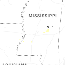
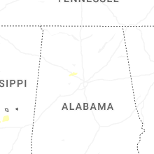
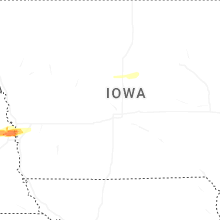
Cities Most Affected by Hail Storms of 4/21/2025
| Hail Size | Demographics of Zip Codes Affected | ||||||
|---|---|---|---|---|---|---|---|
| City | Count | Average | Largest | Pop Density | House Value | Income | Age |
| Omaha, NE | 2 | 1.75 | 1.75 | 3346 | $138k | $59.9k | 33.4 |
Hail and Wind Damage Spotted on 4/21/2025
Filter by Report Type:Hail ReportsWind Reports
Nebraska
| Local Time | Report Details |
|---|---|
| 1:15 PM MDT | Storm damage reported in sheridan county NE, 81.9 miles E of Scottsbluff, NE |
| 4:00 PM CDT | Storm damage reported in brown county NE, 33.5 miles ESE of Valentine, NE |
| 4:31 PM CDT | Storm damage reported in keya paha county NE, 42.2 miles ESE of Valentine, NE |
| 5:53 PM CDT | Storm damage reported in boyd county NE, 25.5 miles NNE of Oneill, NE |
| 10:06 PM CDT | Quarter sized hail reported near Colon, NE, 35 miles W of Omaha, NE, snowball-like hail. |
| 10:19 PM CDT | Ping Pong Ball sized hail reported near Valley, NE, 25.9 miles W of Omaha, NE |
| 10:26 PM CDT | Ping Pong Ball sized hail reported near Valley, NE, 22.7 miles W of Omaha, NE, somewhat flat... disk-shaped hail up to 1.5 inches in diameter. the largest hail was similar to cauliflower... a congealed hailstone made up of many very small hailston |
| 10:38 PM CDT | Half Dollar sized hail reported near Elkhorn, NE, 14.4 miles WNW of Omaha, NE, report from mping: half dollar (1.25 in.). |
| 10:40 PM CDT | Quarter sized hail reported near Elkhorn, NE, 15.7 miles W of Omaha, NE, report from mping: quarter (1.00 in.). |
| 10:42 PM CDT | Quarter sized hail reported near Elkhorn, NE, 13.9 miles WNW of Omaha, NE, report from mping: quarter (1.00 in.). |
| 10:42 PM CDT | Quarter sized hail reported near Bennington, NE, 12.9 miles WNW of Omaha, NE, report from mping: quarter (1.00 in.). |
| 10:42 PM CDT | Half Dollar sized hail reported near Elkhorn, NE, 15.7 miles W of Omaha, NE, half dollar. |
| 10:44 PM CDT | Ping Pong Ball sized hail reported near Elkhorn, NE, 14.4 miles WNW of Omaha, NE, report from mping: ping pong ball (1.50 in.). |
| 10:47 PM CDT | Golf Ball sized hail reported near Omaha, NE, 11.9 miles WNW of Omaha, NE |
| 10:52 PM CDT | Quarter sized hail reported near Omaha, NE, 8.2 miles WNW of Omaha, NE |
| 10:52 PM CDT | Quarter sized hail reported near Omaha, NE, 8.7 miles WNW of Omaha, NE |
| 10:52 PM CDT | Half Dollar sized hail reported near Omaha, NE, 7.9 miles WNW of Omaha, NE, 680 and blair high rd. |
| 10:53 PM CDT | Quarter sized hail reported near Omaha, NE, 8 miles NNW of Omaha, NE |
| 10:54 PM CDT | Quarter sized hail reported near Omaha, NE, 7.1 miles WNW of Omaha, NE |
| 10:54 PM CDT | Quarter sized hail reported near Omaha, NE, 6.9 miles NW of Omaha, NE |
| 10:55 PM CDT | Golf Ball sized hail reported near Omaha, NE, 6.8 miles WNW of Omaha, NE |
| 10:58 PM CDT | Ping Pong Ball sized hail reported near Omaha, NE, 6.2 miles NW of Omaha, NE, report from mping: ping pong ball (1.50 in.). |
| 11:03 PM CDT | Ping Pong Ball sized hail reported near Omaha, NE, 5.6 miles N of Omaha, NE |
| 11:03 PM CDT | Half Dollar sized hail reported near Elkhorn, NE, 13.9 miles WNW of Omaha, NE, report from mping: half dollar (1.25 in.). |
| 11:04 PM CDT | Ping Pong Ball sized hail reported near Omaha, NE, 4 miles NNW of Omaha, NE, report from mping: ping pong ball (1.50 in.). |
| 11:04 PM CDT | Half Dollar sized hail reported near Omaha, NE, 3.7 miles NW of Omaha, NE |
Pennsylvania
| Local Time | Report Details |
|---|---|
| 5:26 PM EDT | Tree down at highway 98 and coleman r in crawford county PA, 76.5 miles E of Cleveland, OH |
| 5:28 PM EDT | Tree down on mcclellan st. ex in crawford county PA, 86 miles ENE of Cleveland, OH |
| 5:29 PM EDT | Tree down at highway 86 and hodges ln... time estimated via rada in crawford county PA, 86.2 miles ENE of Cleveland, OH |
New York
| Local Time | Report Details |
|---|---|
| 6:07 PM EDT | Delayed report. multiple trees down in the town of sto in chautauqua county NY, 57 miles SSW of Buffalo, NY |
| 6:15 PM EDT | Delayed report. multiple trees down on route 60 near the jamestown airpor in chautauqua county NY, 54 miles SSW of Buffalo, NY |
| 6:15 PM EDT | Tree on a house. multiple wires down. time estimated based on rada in chautauqua county NY, 58.7 miles SSW of Buffalo, NY |
| 6:18 PM EDT | Delayed report. multiple trees down near the town line between gerry and ellicot in chautauqua county NY, 53.1 miles SSW of Buffalo, NY |
Connect with Interactive Hail Maps