

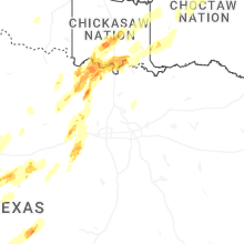
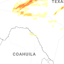
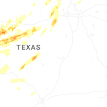
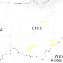
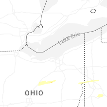
Hail Map for Saturday, April 19, 2025

Number of Impacted Households on 4/19/2025
0
Impacted by 1" or Larger Hail
0
Impacted by 1.75" or Larger Hail
0
Impacted by 2.5" or Larger Hail
Square Miles of Populated Area Impacted on 4/19/2025
0
Impacted by 1" or Larger Hail
0
Impacted by 1.75" or Larger Hail
0
Impacted by 2.5" or Larger Hail

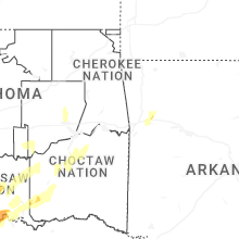

Cities Most Affected by Hail Storms of 4/19/2025
| Hail Size | Demographics of Zip Codes Affected | ||||||
|---|---|---|---|---|---|---|---|
| City | Count | Average | Largest | Pop Density | House Value | Income | Age |
| San Angelo, TX | 2 | 2.38 | 3.00 | 106 | $58k | $35.3k | 35.4 |
| Big Lake, TX | 2 | 1.88 | 2.00 | 3 | $50k | $33.5k | 33.5 |
| Robert Lee, TX | 1 | 2.00 | 2.00 | 2 | $48k | $28.8k | 49.4 |
| Breckenridge, TX | 1 | 2.00 | 2.00 | 16 | $45k | $29.6k | 39.3 |
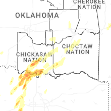
| Lone Grove, OK | 1 | 2.00 | 2.00 | 39 | $58k | $31.3k | 35.7 |
| Ardmore, OK | 1 | 1.75 | 1.75 | 111 | $66k | $30.4k | 38.2 |
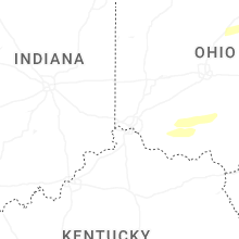
Hail and Wind Damage Spotted on 4/19/2025
Filter by Report Type:Hail ReportsWind Reports
States Impacted
Ohio, Arkansas, New York, Texas, Pennsylvania, Maryland, Kentucky, West Virginia, Oklahoma, Virginia, MissouriOhio
| Local Time | Report Details |
|---|---|
| 8:15 AM EDT | Several powerlines blown down around bowling green townshi in marion county OH, 43.9 miles NNW of Columbus, OH |
| 10:20 AM EDT | Significant garage and outbuilding damage near 5200 block of county road 4. time estimate in logan county OH, 57.7 miles WNW of Columbus, OH |
| 11:41 AM EDT | Delayed report... tall tree with 6 foot diameter trunk fell on power lin in ashland county OH, 62.6 miles NE of Columbus, OH |
| 12:00 PM EDT | Several trees and power lines were blown down in fredericksbur in wayne county OH, 57.7 miles S of Cleveland, OH |
| 12:22 PM EDT | Delayed report - significant tree damage with tops of large pines snapped of in stark county OH, 46.4 miles SSE of Cleveland, OH |
| 4:50 PM EDT | Tree down on car and powerline in clermont county OH, 17.9 miles ESE of Cincinnati, OH |
| 5:36 PM EDT | One tree dow in adams county OH, 51.6 miles ESE of Cincinnati, OH |
| 5:44 PM EDT | Several trees dow in pike county OH, 55.9 miles SSW of Columbus, OH |
| 5:54 PM EDT | Trees uproote in ross county OH, 49.1 miles S of Columbus, OH |
| 5:54 PM EDT | Multiple large trees uprooted and some shingle damage reporte in ross county OH, 46.4 miles S of Columbus, OH |
| 5:56 PM EDT | Trees down throughout the county. time and location estimate in ross county OH, 46.4 miles S of Columbus, OH |
| 6:07 PM EDT | Half Dollar sized hail reported near Waverly, OH, 55.3 miles S of Columbus, OH, mping. |
| 6:15 PM EDT | Power company reports a power outage due to tree damage. time estimated from rada in vinton county OH, 49.2 miles SSE of Columbus, OH |
| 6:20 PM EDT | County 911 reports a tree down on locust grove road... powerlines involve in vinton county OH, 51.6 miles SSE of Columbus, OH |
| 6:20 PM EDT | Power company reports a power outage due to tree damage. time estimated from rada in vinton county OH, 56.4 miles SSE of Columbus, OH |
| 6:25 PM EDT | County 911 reports a tree down on church street in hamde in vinton county OH, 60.8 miles SSE of Columbus, OH |
| 6:25 PM EDT | Vinton county 911 reports multiple trees down in mcarthu in vinton county OH, 57.1 miles SSE of Columbus, OH |
| 6:47 PM EDT | Tree down on a car on meadowbrook road. no occupants. time estimated from rada in athens county OH, 66.7 miles NNW of Charleston, WV |
| 6:50 PM EDT | County 911 relayed numerous tree damage reports in and south of athens... with numerous outages reported by the power company. time estimated from rada in athens county OH, 67.2 miles SE of Columbus, OH |
| 7:01 PM EDT | Photo of a large tree on a hous in athens county OH, 66.6 miles NNW of Charleston, WV |
| 7:08 PM EDT | Spotter reports several pine trees had their tops knocked off... and one large maple tree was uproote in washington county OH, 62.8 miles N of Charleston, WV |
| 7:13 PM EDT | Tree damage. trees uproote in washington county OH, 64.1 miles N of Charleston, WV |
| 7:14 PM EDT | Public sent pictures of a barn destroyed. an adjacent barn has its roofing peeled off in spot in washington county OH, 62.8 miles N of Charleston, WV |
| 7:15 PM EDT | A tree was reported knocked over onto township road 34 in monroe county OH, 88.8 miles SW of Pittsburgh, PA |
| 7:15 PM EDT | Multiple trees down in the are in washington county OH, 64.2 miles N of Charleston, WV |
Arkansas
| Local Time | Report Details |
|---|---|
| 8:05 AM CDT | Trees down mattie and old highway road intersectio in franklin county AR, 21.4 miles ENE of Fort Smith, AR |
| 8:08 AM CDT | Power lines dow in franklin county AR, 21.4 miles ENE of Fort Smith, AR |
| 8:08 AM CDT | Powerlines dow in franklin county AR, 21.4 miles ENE of Fort Smith, AR |
| 8:10 AM CDT | Camper trailer blown over at pence lan in franklin county AR, 34.1 miles ENE of Fort Smith, AR |
New York
| Local Time | Report Details |
|---|---|
| 10:56 AM EDT | Storm damage reported in lez041 county NY, 36.4 miles SW of Buffalo, NY |
| 11:00 AM EDT | Corrects previous non-tstm wnd gst report from 3 ene dunkirk. asos station kdkk dunkirk airpor in chautauqua county NY, 33.6 miles SW of Buffalo, NY |
| 11:09 AM EDT | Trees and wires down. time estimated by rada in erie county NY, 17.6 miles SSW of Buffalo, NY |
| 11:28 AM EDT | Trees and wires down. time estimated by rada in erie county NY, 12.9 miles ESE of Buffalo, NY |
| 11:28 AM EDT | Trees and wires down. time estimated by rada in erie county NY, 11 miles ESE of Buffalo, NY |
| 11:39 AM EDT | Delayed report. trees and wires down with over 1...000 customers without power from pembroke to batavia. time estimated by rada in genesee county NY, 25.6 miles ENE of Buffalo, NY |
| 11:52 AM EDT | Delayed report. trees and wires down with over 1...000 customers without power from pembroke to batavia. time estimated by rada in genesee county NY, 35.8 miles ENE of Buffalo, NY |
| 12:17 PM EDT | Trees and wires down. time estimated by rada in monroe county NY, 51.7 miles ENE of Buffalo, NY |
| 12:23 PM EDT | Trees and wires down. time estimated by rada in monroe county NY, 63.7 miles ENE of Buffalo, NY |
| 12:26 PM EDT | Trees and wires down. time estimated by rada in monroe county NY, 66.7 miles ENE of Buffalo, NY |
| 5:06 PM EDT | Tree down across roadway at route 97 and viaduct r in sullivan county NY, 39.8 miles NE of Scranton, PA |
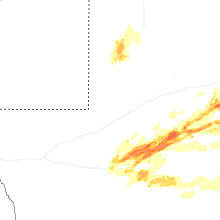
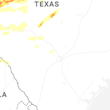
Texas
| Local Time | Report Details |
|---|---|
| 11:40 AM CDT | Half Dollar sized hail reported near Bridgeport, TX, 63.4 miles WNW of Dallas, TX, half dollar size hail reported in bridgeport. |
| 3:32 PM CDT | Ping Pong Ball sized hail reported near Mc Camey, TX, 51.7 miles S of Odessa, TX, trained spotter reports quarter to ping pong sized hail one half mile to 3 miles south of mccamey. |
| 4:02 PM CDT | Hen Egg sized hail reported near Big Lake, TX, 69.7 miles SE of Odessa, TX, report from mping: hen egg (2.00 in.). |
| 4:48 PM CDT | Quarter sized hail reported near Sterling City, TX, 82.2 miles WSW of Abilene, TX, report from mping: quarter (1.00 in.). |
| 5:10 PM CDT | Golf Ball sized hail reported near Big Lake, TX, 67.5 miles SE of Odessa, TX, ping pong to golfball ball sized hail observed on the road from chaser footage north of big lake. |
| 5:34 PM CDT | Quarter sized hail reported near Robert Lee, TX, 62.4 miles SW of Abilene, TX, report from mping: quarter (1.00 in.). |
| 5:35 PM CDT | Hen Egg sized hail reported near Robert Lee, TX, 61.5 miles SW of Abilene, TX, 2.25 inch hail measured west of robert lee. |
| 5:49 PM CDT | Quarter sized hail reported near Mc Camey, TX, 49.7 miles S of Odessa, TX, law enforcement reports nickel to quarter size hail in mccamey. |
| 6:05 PM CDT | Hen Egg sized hail reported near Breckenridge, TX, 48 miles ENE of Abilene, TX, 2 inch diameter hail reported on hubbard creek lake. |
| 6:50 PM CDT | Half Dollar sized hail reported near Rankin, TX, 50.4 miles SSE of Odessa, TX, quarter to half-dollar size hail at the sheriffs office in rankin. |
| 8:00 PM CDT | Tea Cup sized hail reported near , , 54.5 miles SE of Odessa, TX, 3 inch hail reported 8 miles east of rankin. |
| 8:25 PM CDT | Half Dollar sized hail reported near Wingate, TX, 35.5 miles SW of Abilene, TX |
| 8:55 PM CDT | Quarter sized hail reported near Tuscola, TX, 16.5 miles SSW of Abilene, TX, report from mping: quarter (1.00 in.). |
| 9:05 PM CDT | Quarter sized hail reported near Tuscola, TX, 13.3 miles SSW of Abilene, TX, report from mping: quarter (1.00 in.). |
| 9:15 PM CDT | Tea Cup sized hail reported near San Angelo, TX, 78.4 miles SW of Abilene, TX, picture of hail stone on social media. |
| 9:21 PM CDT | Golf Ball sized hail reported near San Angelo, TX, 78.4 miles SW of Abilene, TX |
| 9:44 PM CDT | Quarter sized hail reported near San Angelo, TX, 71 miles SSW of Abilene, TX |
| 9:52 PM CDT | Storm damage reported in tom green county TX, 77 miles SW of Abilene, TX |
| 10:06 PM CDT | Half Dollar sized hail reported near Ropesville, TX, 18.1 miles SW of Lubbock, TX |
| 12:14 AM CDT | Storm damage reported in tom green county TX, 88.5 miles SSW of Abilene, TX |
Pennsylvania
| Local Time | Report Details |
|---|---|
| 1:37 PM EDT | Em reported a few trees down including one on power line in butler county PA, 26.6 miles N of Pittsburgh, PA |
| 1:44 PM EDT | Report of trees down along larchwood drive near route 8. time estimated based on rada in butler county PA, 24.5 miles N of Pittsburgh, PA |
| 1:45 PM EDT | Public report with pictures of trees down near country club heights lane in penn township. time estimated based on rada in butler county PA, 24.5 miles N of Pittsburgh, PA |
| 1:45 PM EDT | Report of multiple trees down along route 8 near succop nature reserve. time estimated based on rada in butler county PA, 23.8 miles N of Pittsburgh, PA |
| 1:46 PM EDT | Trees dow in butler county PA, 24.5 miles N of Pittsburgh, PA |
| 1:48 PM EDT | A tree fell down on private propert in butler county PA, 25.7 miles N of Pittsburgh, PA |
| 1:50 PM EDT | Report of a lot of trees and wires down in the summit township area. time estimated based on rada in butler county PA, 28.8 miles NNE of Pittsburgh, PA |
| 2:05 PM EDT | Quarter sized hail reported near Mars, PA, 18.8 miles N of Pittsburgh, PA |
| 2:53 PM EDT | Numerous trees and wires down between hyde and clearfiel in clearfield county PA, 37.2 miles WNW of State College, PA |
| 2:54 PM EDT | Numerous trees and wires down in clearfield prope in clearfield county PA, 34.4 miles WNW of State College, PA |
| 3:00 PM EDT | Rwis roadway sensor at clearfield-shawville sr879/ exit #120 of interstate 8 in clearfield county PA, 29.6 miles WNW of State College, PA |
| 4:04 PM EDT | Tree dow in lycoming county PA, 61.1 miles W of Scranton, PA |
| 4:11 PM EDT | Tree down on roadwa in lycoming county PA, 53.6 miles WSW of Scranton, PA |
| 4:15 PM EDT | Tree down on wire in lycoming county PA, 46.2 miles WSW of Scranton, PA |
| 4:30 PM EDT | Trees and wires down in the are in susquehanna county PA, 32.6 miles N of Scranton, PA |
| 4:45 PM EDT | Several trees and wires down in the are in lackawanna county PA, 0.8 miles SW of Scranton, PA |
| 4:50 PM EDT | Multiple trees down along washington ave. relayed via nws alban in lackawanna county PA, 10.1 miles NE of Scranton, PA |
| 5:05 PM EDT | Several reports of trees and wires down in the are in wayne county PA, 23.4 miles ENE of Scranton, PA |
| 6:16 PM EDT | This gust was measured by a btmeter handheld anemomete in westmoreland county PA, 30.7 miles ESE of Pittsburgh, PA |
| 6:33 PM EDT | Two trees dow in washington county PA, 20.7 miles S of Pittsburgh, PA |
| 6:43 PM EDT | Quarter sized hail reported near Charleroi, PA, 21.2 miles SSE of Pittsburgh, PA |
| 6:45 PM EDT | A power pole was brought down over finley roa in westmoreland county PA, 22.4 miles SSE of Pittsburgh, PA |
| 6:55 PM EDT | Trees and wires dow in westmoreland county PA, 26.7 miles SE of Pittsburgh, PA |
| 8:24 PM EDT | Trees dow in fayette county PA, 49.1 miles S of Pittsburgh, PA |
| 9:12 PM EDT | Multiple trees down on roadwa in bedford county PA, 79.3 miles SE of Pittsburgh, PA |
| 9:21 PM EDT | Wires down in southampton townshi in bedford county PA, 77.5 miles SSW of State College, PA |
| 9:38 PM EDT | A tree fell onto a car in belfast townshi in fulton county PA, 67.7 miles SSW of State College, PA |
| 9:39 PM EDT | Trees/wires dow in fulton county PA, 75.2 miles SSW of State College, PA |
| 9:49 PM EDT | Multiple trees dow in franklin county PA, 66.5 miles S of State College, PA |
| 9:50 PM EDT | Damage to powerlines throughout mercersbur in franklin county PA, 66.5 miles S of State College, PA |
| 9:58 PM EDT | Trees and wires down in greencastl in franklin county PA, 69.1 miles WNW of Baltimore, MD |
| 9:59 PM EDT | Multiple trees dow in franklin county PA, 69.1 miles WNW of Baltimore, MD |
| 10:00 PM EDT | Multiple trees and wires down in waynesbor in franklin county PA, 60.8 miles WNW of Baltimore, MD |
| 10:25 PM EDT | Tree down on a hous in adams county PA, 40.3 miles NW of Baltimore, MD |
| 10:28 PM EDT | Several trees down on power lines and blocking the road near the intersection of bankard road and kreidlers schoolhouse road... northeast along pleasant hill roa in york county PA, 35.4 miles NNW of Baltimore, MD |
Maryland
| Local Time | Report Details |
|---|---|
| 2:35 PM EDT | At least six trees down on md-30 near manchester blocking the roa in carroll county MD, 29.6 miles NNW of Baltimore, MD |
| 8:42 PM EDT | Numerous calls received of tree damage in the friendsville area in garrett county MD, 55.9 miles NNE of Elkins, WV |
| 8:53 PM EDT | Storm damage reported in garrett county MD, 62.3 miles NNE of Elkins, WV |
| 8:55 PM EDT | Apprixomately 200 calls for storm related damage in the northern half of garrett count in garrett county MD, 56.2 miles NNE of Elkins, WV |
| 8:55 PM EDT | Structural damage to a home in friendsville with significant roof damage. roof partially blown off. power lines and poles laying on hom in garrett county MD, 55.9 miles NNE of Elkins, WV |
| 9:00 PM EDT | Storm damage reported in garrett county MD, 50.1 miles NNE of Elkins, WV |
| 9:00 PM EDT | Maryland mesonet site bittinger 3 ssw in garrett county MD, 55.1 miles NE of Elkins, WV |
| 9:03 PM EDT | Over a dozen trees snapped at the base on pochantas roa in allegany county MD, 70.1 miles NE of Elkins, WV |
| 9:08 PM EDT | 50 foot tall tree down on power line... many branches down in allegany county MD, 75.9 miles NE of Elkins, WV |
| 9:11 PM EDT | Over a hundred calls relating to storm damage. trees down everywhere across the northern portion of the count in allegany county MD, 76.7 miles NE of Elkins, WV |
| 9:29 PM EDT | Multiple large limbs down on property in allegany county MD, 80.1 miles SSW of State College, PA |
| 10:00 PM EDT | Extensive damage from hagerstown to smithsburg including numerous trees down... roof damage... shed destroyed in washington county MD, 57.8 miles WNW of Baltimore, MD |
| 10:00 PM EDT | Private weather station hgntc in washington county MD, 63.1 miles WNW of Baltimore, MD |
| 10:00 PM EDT | Storm damage reported in washington county MD, 66.5 miles WNW of Baltimore, MD |
| 10:01 PM EDT | At least a dozen trees down across hagerstow in washington county MD, 64.1 miles WNW of Baltimore, MD |
| 10:01 PM EDT | Over a dozen trees down in thurmont to emmitsburg. numerous roads close in frederick county MD, 48.3 miles WNW of Baltimore, MD |
| 10:04 PM EDT | Measured on personal weather station in washington county MD, 60 miles WNW of Baltimore, MD |
| 10:05 PM EDT | Cwop station cw1323 in washington county MD, 63.1 miles WNW of Baltimore, MD |
| 10:09 PM EDT | Mddot sensor md 64 at md 418 in washington county MD, 58.9 miles WNW of Baltimore, MD |
| 10:12 PM EDT | Awos at camp david in frederick county MD, 52.3 miles WNW of Baltimore, MD |
| 10:12 PM EDT | Maryland mesonet station thurmont 1 ne in frederick county MD, 48.7 miles WNW of Baltimore, MD |
| 10:15 PM EDT | Cwop station dw1771 in frederick county MD, 46.7 miles WNW of Baltimore, MD |
| 10:21 PM EDT | Reports of damage to a shed that was tossed in the thunderstorm winds. also multiple reports of tree damage across northern carroll count in carroll county MD, 39.4 miles NW of Baltimore, MD |
| 10:28 PM EDT | Awos at carroll county regional airport in carroll county MD, 30.7 miles NW of Baltimore, MD |
| 10:35 PM EDT | At least six trees down on md-30 near manchester blocking the road. corrected tim in carroll county MD, 29.6 miles NNW of Baltimore, MD |
| 10:38 PM EDT | Storm damage reported in carroll county MD, 31.3 miles NNW of Baltimore, MD |
| 10:43 PM EDT | Reports of a number of trees and power lines down across white hall... md in baltimore county MD, 22.8 miles N of Baltimore, MD |
| 10:45 PM EDT | Numerous reports of trees down in the northern portion of baltimore county. some on cars and structures. area near prettyboy reservoir has the most widespread damage. l in baltimore county MD, 22.7 miles NNW of Baltimore, MD |
| 10:54 PM EDT | Reports of a number of trees and power lines down across street... m in harford county MD, 28.9 miles NNE of Baltimore, MD |
Kentucky
| Local Time | Report Details |
|---|---|
| 4:39 PM EDT | Tree snappe in campbell county KY, 12.8 miles SE of Cincinnati, OH |
| 4:45 PM EDT | 3 inch limbs broke in campbell county KY, 13.2 miles SE of Cincinnati, OH |
West Virginia
| Local Time | Report Details |
|---|---|
| 7:10 PM EDT | County 911 received several reports of trees and lines down in the washington and lubeck areas. time estimated from rada in wood county WV, 62.1 miles N of Charleston, WV |
| 7:17 PM EDT | Damage to shingles on a roo in wood county WV, 64.5 miles N of Charleston, WV |
| 7:18 PM EDT | County 911 reports nearly a dozen calls about trees and lines down in the vienna area. time estimated from rada in wood county WV, 67.8 miles N of Charleston, WV |
| 7:20 PM EDT | County 911 received around two dozen reports of trees or lines down in parkersburg. numerous power outages also noted via power company outage ma in wood county WV, 62.9 miles N of Charleston, WV |
| 7:22 PM EDT | County 911 relayed several reports of trees and lines down in the williamstown and boaz areas. time estimated from rada in wood county WV, 71 miles N of Charleston, WV |
| 7:25 PM EDT | Trees and lines down on williamstown pike near the airpor in wood county WV, 69.9 miles N of Charleston, WV |
| 7:27 PM EDT | County 911 reports a tree down on lines with a broken pole on atkinson ridge road in walker. time estimated from rada in wood county WV, 57 miles NNE of Charleston, WV |
| 7:28 PM EDT | County 911 reports tree damage at deerwalk highway and us-50. time estimated from rada in wood county WV, 64.3 miles NNE of Charleston, WV |
| 7:36 PM EDT | Tree dow in wetzel county WV, 71.6 miles SW of Pittsburgh, PA |
| 7:42 PM EDT | Multiple trees dow in wetzel county WV, 65.9 miles SW of Pittsburgh, PA |
| 7:44 PM EDT | Trees dow in wetzel county WV, 68.5 miles NW of Elkins, WV |
| 7:56 PM EDT | Tree across the roa in wetzel county WV, 56.5 miles SSW of Pittsburgh, PA |
| 8:06 PM EDT | Multiple trees dow in monongalia county WV, 54.4 miles SSW of Pittsburgh, PA |
| 8:10 PM EDT | Tree dow in marion county WV, 49.5 miles NNW of Elkins, WV |
| 8:17 PM EDT | Trees down on cassville mt morris r in monongalia county WV, 51 miles S of Pittsburgh, PA |
| 8:22 PM EDT | Tree dow in marion county WV, 41.7 miles NNW of Elkins, WV |
| 8:23 PM EDT | Report of blown out windows and doors along with roof damage in the falling water neighborhood of cheat lake. time estimated based on rada in monongalia county WV, 51.5 miles S of Pittsburgh, PA |
| 8:24 PM EDT | Images shared of wind blown debris damaging home at cheat lake. time estimated based on rada in monongalia county WV, 51.5 miles N of Elkins, WV |
| 8:25 PM EDT | 3 trees down on separate houses. numerous other trees reported down in the are in monongalia county WV, 49.1 miles N of Elkins, WV |
| 8:25 PM EDT | Tree down into a structur in monongalia county WV, 51.3 miles N of Elkins, WV |
| 8:26 PM EDT | Reported at morgantown airpor in monongalia county WV, 49.6 miles N of Elkins, WV |
| 8:26 PM EDT | Building collapse and numerous trees dow in monongalia county WV, 51.6 miles S of Pittsburgh, PA |
| 8:29 PM EDT | Numerous trees down across the are in monongalia county WV, 51.5 miles N of Elkins, WV |
| 8:31 PM EDT | Tree and numerous limbs dow in preston county WV, 50.9 miles N of Elkins, WV |
| 8:35 PM EDT | Tree down on a house. numerous other trees reported down throughout the are in preston county WV, 51.3 miles N of Elkins, WV |
| 8:36 PM EDT | Tree dow in preston county WV, 40.5 miles N of Elkins, WV |
| 8:37 PM EDT | Tree dow in preston county WV, 51.9 miles NNE of Elkins, WV |
| 8:40 PM EDT | Numerous large limbs dow in preston county WV, 39.8 miles N of Elkins, WV |
| 9:10 PM EDT | At least a dozen reports of trees down in the far northern part of the county. corrected tim in mineral county WV, 75.9 miles NE of Elkins, WV |
| 9:11 PM EDT | Awos at cumberland regional airport in mineral county WV, 75.4 miles NE of Elkins, WV |
| 9:34 PM EDT | Over 100 calls for trees down in the county. several reports of trees down on cars. several reports of trees on structures. numerous roads closed throughout the norther in morgan county WV, 82.6 miles SSW of State College, PA |
| 9:35 PM EDT | Dozens of trees down in neighborhood in morgan county WV, 83.7 miles SSW of State College, PA |
| 9:49 PM EDT | Extensive wind damage in the spring mills area in berkeley county WV, 74.1 miles WNW of Baltimore, MD |
| 10:43 PM EDT | At least a dozen reports of trees down in the far northern part of the county in mineral county WV, 75.9 miles NE of Elkins, WV |
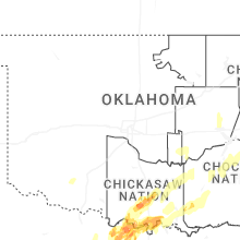
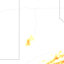
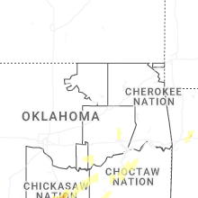
Oklahoma
| Local Time | Report Details |
|---|---|
| 9:07 PM CDT | Golf Ball sized hail reported near Ardmore, OK, 67.3 miles WSW of Atoka, OK |
| 9:19 PM CDT | Quarter sized hail reported near Ardmore, OK, 61.1 miles WSW of Atoka, OK, report from mping: quarter (1.00 in.). |
| 9:26 PM CDT | Hen Egg sized hail reported near Lone Grove, OK, 66.3 miles WSW of Atoka, OK |
| 9:30 PM CDT | West side of ardmore on i-3 in carter county OK, 59.8 miles WSW of Atoka, OK |
| 11:12 PM CDT | Trees and power poles damaged along stallings road and decker road s of emet and northwest of nida. likely tornad in johnston county OK, 27.4 miles WSW of Atoka, OK |
| 11:33 PM CDT | Half Dollar sized hail reported near Durant, OK, 31.7 miles SSW of Atoka, OK |
| 11:50 PM CDT | Large tree down northwest of pierce along i-4 in mcintosh county OK, 50.5 miles SSE of Tulsa, OK |
| 12:29 AM CDT | Quarter sized hail reported near Kiowa, OK, 26.8 miles NNE of Atoka, OK, report from mping: quarter (1.00 in.). |
Virginia
| Local Time | Report Details |
|---|---|
| 10:45 PM EDT | Numerous reports of trees down in the northern portion of baltimore county. some on cars and structures. area near prettyboy reservoir has the most widespread damag in albemarle county VA, 73.5 miles NW of Richmond, VA |
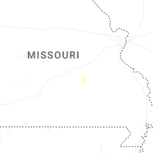
Missouri
| Local Time | Report Details |
|---|---|
| 4:58 AM CDT | Quarter sized hail reported near Salem, MO, 2.1 miles NW of Salem, MO |
Connect with Interactive Hail Maps