

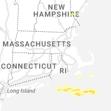
Hail Map for Sunday, August 13, 2023

Number of Impacted Households on 8/13/2023
0
Impacted by 1" or Larger Hail
0
Impacted by 1.75" or Larger Hail
0
Impacted by 2.5" or Larger Hail
Square Miles of Populated Area Impacted on 8/13/2023
0
Impacted by 1" or Larger Hail
0
Impacted by 1.75" or Larger Hail
0
Impacted by 2.5" or Larger Hail


Cities Most Affected by Hail Storms of 8/13/2023
| Hail Size | Demographics of Zip Codes Affected | ||||||
|---|---|---|---|---|---|---|---|
| City | Count | Average | Largest | Pop Density | House Value | Income | Age |
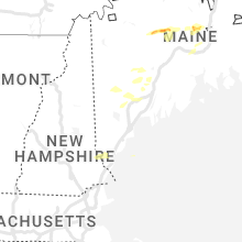
| Harmony, ME | 4 | 1.88 | 2.00 | 6 | $62k | $24.1k | 49.8 |
| Bingham, ME | 1 | 1.75 | 1.75 | 3 | $59k | $27.0k | 46.8 |
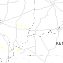
| Arnett, OK | 1 | 1.75 | 1.75 | 1 | $30k | $28.2k | 45.5 |
| Somersworth, NH | 1 | 1.75 | 1.75 | 1251 | $105k | $43.2k | 37.9 |
Hail and Wind Damage Spotted on 8/13/2023
Filter by Report Type:Hail ReportsWind Reports
States Impacted
Missouri, Oklahoma, New Hampshire, Maine, Tennessee, Alabama, Massachusetts, New Mexico, Texas, Kansas, CaliforniaMissouri
| Local Time | Report Details |
|---|---|
| 8:55 AM CDT | Power line reported down in brayme in caldwell county MO, 53.7 miles NE of Kansas City, MO |
| 9:01 AM CDT | Power line was downed in town. another business reported a power outage. time estimated by rada in carroll county MO, 60.8 miles ENE of Kansas City, MO |
| 7:02 PM CDT | Personal weather station recorded 65 mph wind gus in platte county MO, 10.3 miles NNW of Kansas City, MO |
| 7:06 PM CDT | Several tree limbs down some up to 8 in. in diameter. reported via social media. time estimated via rada in platte county MO, 7.8 miles NNW of Kansas City, MO |
| 7:14 PM CDT | Report from mping: 1-inch tree limbs broke in platte county MO, 8.1 miles N of Kansas City, MO |
| 8:51 PM CDT | Quarter sized hail reported near Neosho, MO, 68.7 miles WSW of Springfield, MO, quarter sized hail reported west of neosho along highway 86 in newton county. |
| 9:15 PM CDT | Awos station khfj monett awo in barry county MO, 45.5 miles WSW of Springfield, MO |
| 9:20 PM CDT | Quarter sized hail reported near Monett, MO, 39.9 miles WSW of Springfield, MO, report from mping: quarter (1.00 in.). |
| 10:30 PM CDT | Report from mping: 3-inch tree limbs broken; power poles broke in stone county MO, 32.5 miles S of Springfield, MO |
| 10:30 PM CDT | Tree down near 6th/church intersection - size approx. 18-24 in diamete in jasper county MO, 46.7 miles WSW of Springfield, MO |
| 11:01 PM CDT | Report from mping: 1-inch tree limbs broken; shingles blown of in taney county MO, 37.8 miles SSE of Springfield, MO |
| 11:12 PM CDT | Four to five inch tree limbs down. time based on radar estimat in camden county MO, 55.4 miles NNE of Springfield, MO |
| 11:30 PM CDT | Report of damage to a roof from thunderstorm winds. time estimated via rada in laclede county MO, 52.5 miles NE of Springfield, MO |
| 11:35 PM CDT | Awos station kozs camdenton awo in camden county MO, 62.3 miles NNE of Springfield, MO |
Oklahoma
| Local Time | Report Details |
|---|---|
| 10:50 AM CDT | At least a dozen buildings damaged from thunderstorm winds. trees are also reported on cars and several power poles have been damage in kingfisher county OK, 48.9 miles NNW of Oklahoma City, OK |
| 6:27 PM CDT | Golf Ball sized hail reported near Arnett, OK, 31.5 miles SW of Woodward, OK |
| 6:27 PM CDT | Time estimated from rada in ellis county OK, 31.5 miles SW of Woodward, OK |
| 8:06 PM CDT | Quarter sized hail reported near Laverne, OK, 20.1 miles NNW of Woodward, OK |
| 8:53 PM CDT | Asos station kcsm clinto in washita county OK, 75.5 miles S of Woodward, OK |
| 9:44 PM CDT | 3-inch tree limbs broke in ottawa county OK, 68.7 miles SE of Chanute, KS |
| 9:45 PM CDT | Storm damage reported in caddo county OK, 54.1 miles W of Oklahoma City, OK |
| 9:49 PM CDT | Storm damage reported in caddo county OK, 54.1 miles W of Oklahoma City, OK |
| 10:50 PM CDT | Pole knocked over and leaning against power pol in logan county OK, 33.3 miles N of Oklahoma City, OK |
| 10:50 PM CDT | Power outage and tree damag in kingfisher county OK, 48.9 miles NNW of Oklahoma City, OK |
| 11:20 PM CDT | Storm damage reported in logan county OK, 43.5 miles N of Oklahoma City, OK |
| 11:27 PM CDT | Storm damage reported in garfield county OK, 76.3 miles NNW of Oklahoma City, OK |
| 11:28 PM CDT | Storm damage reported in logan county OK, 35.7 miles NNE of Oklahoma City, OK |
| 11:30 PM CDT | Storm damage reported in logan county OK, 44.2 miles N of Oklahoma City, OK |
| 11:35 PM CDT | Mesonet station oilt oilto in creek county OK, 29.5 miles WSW of Tulsa, OK |
| 11:38 PM CDT | Storm damage reported in payne county OK, 45 miles NNE of Oklahoma City, OK |
| 11:40 PM CDT | Storm damage reported in payne county OK, 43.5 miles NNE of Oklahoma City, OK |
| 11:45 PM CDT | Storm damage reported in payne county OK, 43.5 miles NNE of Oklahoma City, OK |
| 11:50 PM CDT | Storm damage reported in payne county OK, 45 miles NE of Oklahoma City, OK |
| 12:01 AM CDT | Storm damage reported in tulsa county OK, 7.9 miles WSW of Tulsa, OK |
| 12:09 AM CDT | Power line dow in tulsa county OK, 3.7 miles SSE of Tulsa, OK |
| 12:20 AM CDT | Storm damage reported in rogers county OK, 13.2 miles NE of Tulsa, OK |
| 12:20 AM CDT | Large tree blocking the road. many large trees down in the are in rogers county OK, 14.5 miles NE of Tulsa, OK |
| 12:20 AM CDT | Asos station ktul tuls in tulsa county OK, 7.2 miles ENE of Tulsa, OK |
| 12:20 AM CDT | Several power poles dow in tulsa county OK, 13.3 miles NE of Tulsa, OK |
| 12:20 AM CDT | Several power poles dow in tulsa county OK, 13.3 miles NE of Tulsa, OK |
| 12:20 AM CDT | Hangar damaged at gundys airport. considerable tree damage and power lines down in the vicinity. time estimated from rada in rogers county OK, 14.5 miles NE of Tulsa, OK |
| 12:23 AM CDT | Storm damage reported in rogers county OK, 13.1 miles ENE of Tulsa, OK |
| 12:30 AM CDT | Numerous large tree limbs down with power outages. winds estimated 60 to 70 mp in osage county OK, 28.9 miles NW of Tulsa, OK |
| 12:35 AM CDT | Mesonet station wyno wynon in osage county OK, 32 miles NW of Tulsa, OK |
| 12:45 AM CDT | Storm damage reported in mayes county OK, 36.6 miles E of Tulsa, OK |
| 1:08 AM CDT | Large branches dow in cherokee county OK, 50.1 miles ESE of Tulsa, OK |
New Hampshire
| Local Time | Report Details |
|---|---|
| 1:44 PM EDT | Half Dollar sized hail reported near Barrington, NH, 48.6 miles SW of Portland, ME, reported by weather spotter. delayed report: 1.25 inch hail reported. time estimated by radar. |
| 1:47 PM EDT | Spotter reported 60 year old pine tree blown over near nh 125... and a business sign was blown over. time estimated by rada in strafford county NH, 46.9 miles SW of Portland, ME |
| 1:50 PM EDT | Ping Pong Ball sized hail reported near Rochester, NH, 45.6 miles SW of Portland, ME, reported by amateur radio. time estimated by radar. |
| 2:00 PM EDT | Quarter sized hail reported near Somersworth, NH, 43.5 miles SW of Portland, ME, corrects previous hail report from 2 nnw dover. reported by weather spotter. |
| 2:00 PM EDT | Golf Ball sized hail reported near Somersworth, NH, 41.6 miles SW of Portland, ME, reported by weather spotter. |
| 2:10 PM EDT | Quarter sized hail reported near Somersworth, NH, 43.5 miles SW of Portland, ME, reported by weather spotter. |
| 3:53 PM EDT | Reported by amateur radio. tree down on us-3 just south of colebroo in coos county NH, 84.9 miles ENE of Burlington, VT |
| 4:02 PM EDT | Quarter sized hail reported near Dover, NH, 45.1 miles SW of Portland, ME, reported by amateur radio. time estimated by radar. |
| 4:34 PM EDT | Reported by weather spotter. a few trees down near riverlea farm. time estimated by rada in rockingham county NH, 56.7 miles SW of Portland, ME |
Maine
| Local Time | Report Details |
|---|---|
| 1:54 PM EDT | Powerlines down on agamanticus road. time estimated by rada in york county ME, 39.5 miles SW of Portland, ME |
| 2:26 PM EDT | Golf Ball sized hail reported near Bingham, ME, 55.9 miles WNW of Bangor, ME, social media photos and videos of golf ball size hail in bingham. time estimated by radar. |
| 2:28 PM EDT | Half Dollar sized hail reported near Bingham, ME, 56.4 miles WNW of Bangor, ME, half dollar size hail reported. time estimated by radar. |
| 2:30 PM EDT | Dispatch reported a tree down on us 202... and blocking one lane. time estimated by rada in kennebec county ME, 43.7 miles NNE of Portland, ME |
| 2:30 PM EDT | Quarter sized hail reported near North Monmouth, ME, 43.7 miles NNE of Portland, ME, time estimated by radar. |
| 3:09 PM EDT | Golf Ball sized hail reported near Harmony, ME, 46.6 miles WNW of Bangor, ME |
| 3:10 PM EDT | Hen Egg sized hail reported near Harmony, ME, 43.9 miles WNW of Bangor, ME, corrects previous hail report from wellington. |
| 3:13 PM EDT | Multiple trees down... including a large tree down on a roof causing damage to a roof and solar panels. tree limbs down on lines causing a power outag in piscataquis county ME, 44.5 miles WNW of Bangor, ME |
| 3:14 PM EDT | Golf Ball sized hail reported near Harmony, ME, 44.5 miles WNW of Bangor, ME |
| 3:34 PM EDT | Quarter sized hail reported near Jay, ME, 62.3 miles N of Portland, ME, corrects the time of previous reports of hail 3 se wilton. delayed report. time estimated by radar. |
| 3:42 PM EDT | Half Dollar sized hail reported near Fairfield, ME, 45.7 miles WSW of Bangor, ME, time estimated by radar. hail from photo on social media. |
| 3:44 PM EDT | Tree down. time estimated by rada in kennebec county ME, 62.1 miles WSW of Bangor, ME |
| 3:45 PM EDT | Hen Egg sized hail reported near Harmony, ME, 43.9 miles WNW of Bangor, ME |
| 4:14 PM EDT | Quarter sized hail reported near Norway, ME, 40.6 miles NNW of Portland, ME, social media photo of quarter size hail. time estimated by radar. |
| 4:16 PM EDT | 2 trees down. one on wires. time estimated by rada in androscoggin county ME, 51.3 miles N of Portland, ME |
| 4:20 PM EDT | Tree down on road. time estimated by rada in androscoggin county ME, 52.1 miles N of Portland, ME |
| 4:23 PM EDT | Ping Pong Ball sized hail reported near Charleston, ME, 23.9 miles NNW of Bangor, ME, photo via social media of ping pong ball sized hail in charleston. time estimated by radar. |
| 4:31 PM EDT | Photos via social media show numerous trees down on powerlines. at least 20 trees are down or on powerlines between route 11a split and bradford general store. power re in penobscot county ME, 20.3 miles NNW of Bangor, ME |
| 4:34 PM EDT | Quarter sized hail reported near Jay, ME, 62.3 miles N of Portland, ME, corrects previous hail report from 3 se wilton. delayed report. time estimated by radar. |
| 5:28 PM EDT | Delayed report: tree down on north street... road closed at time of report. time estimated by rada in androscoggin county ME, 32.6 miles NNW of Portland, ME |
| 5:32 PM EDT | Delayed report: tree down on phelan street. reported by nws employee. time estimated by rada in androscoggin county ME, 32.7 miles NNE of Portland, ME |
| 5:34 PM EDT | Delayed report: several trees and wires down on and near garfield road in minot. time estimated by rada in androscoggin county ME, 31.2 miles N of Portland, ME |
| 5:34 PM EDT | Quarter sized hail reported near Jay, ME, 62.3 miles N of Portland, ME, delayed report. time estimated by radar. |
Tennessee
| Local Time | Report Details |
|---|---|
| 1:03 PM CDT | Multiple trees down in cedar grove along highway 70 at he intersection of hwy 70/hwy 104 reported impassible multiple trees down across the county-multiple units dispat in carroll county TN, 21.9 miles S of Mc Kenzie, TN |
| 1:15 PM CDT | Part of a roof blew off of a large barn... large oak tree fell on a small bar in carroll county TN, 10.4 miles SSE of Mc Kenzie, TN |
| 1:35 PM CDT | Multiple reports of trees down blocking roads and powerlines down across benton c in benton county TN, 25 miles E of Mc Kenzie, TN |
| 2:09 PM CDT | Report of large tree down blocking highway 120 between big rock and bumpus mill in stewart county TN, 50.2 miles NE of Mc Kenzie, TN |
| 2:10 PM CDT | Corrects previous flash flood report from erin. scattered trees and power lines down across the county... mainly in southeast portions between hwy 13 and hwy 231 near t in houston county TN, 47.6 miles ENE of Mc Kenzie, TN |
| 2:44 PM CDT | Tspotter report of 3 large oak trees down at i-40 and highway 9 in williamson county TN, 24.4 miles WSW of Nashville, TN |
| 2:45 PM CDT | Facebook report of large tree branches down in clarksvill in montgomery county TN, 41.8 miles NW of Nashville, TN |
| 3:01 PM CDT | Tspotter photo of a tree down on hwy 70s near the lakes apartments in bellevu in davidson county TN, 9.5 miles SW of Nashville, TN |
| 3:06 PM CDT | Tspotter photo of a tree down blocking south berrrys chapel rd in hillsbor in williamson county TN, 14.4 miles SSW of Nashville, TN |
| 3:10 PM CDT | Tspotter photo of a tree down on a house in frankli in williamson county TN, 16.8 miles SSW of Nashville, TN |
| 3:16 PM CDT | Large oak tree down blocking robin rd in oak hil in davidson county TN, 4 miles S of Nashville, TN |
| 3:17 PM CDT | Tspotter photo of a tree down in 12 sout in davidson county TN, 3.4 miles S of Nashville, TN |
| 3:20 PM CDT | Tspotter photo of tree down behind southern hills medical cente in davidson county TN, 6.9 miles SSE of Nashville, TN |
| 3:21 PM CDT | Tspotter photo of a large tree down blocking abbay driv in davidson county TN, 6.4 miles SSE of Nashville, TN |
| 3:22 PM CDT | Tspotter photo of a tree down on power line in east nashvill in davidson county TN, 1 miles E of Nashville, TN |
| 3:24 PM CDT | Tree down on carport in glenclif in davidson county TN, 10.5 miles E of Nashville, TN |
| 3:28 PM CDT | Tspotter photo of a tree down at asheford crossing in antioc in davidson county TN, 12.5 miles SE of Nashville, TN |
| 3:40 PM CDT | Tspotter photo of a tree down on swinging bridge rd in old hickor in davidson county TN, 9.8 miles NE of Nashville, TN |
| 3:40 PM CDT | Nes reports 9259 customers without powe in davidson county TN, 0.2 miles NNW of Nashville, TN |
| 3:48 PM CDT | Large tree limb down blocking rucker ln at confederate r in rutherford county TN, 28.4 miles SE of Nashville, TN |
| 4:45 PM CDT | Trained spotter reports large branches and a few weak trees were blown down in southwest sections of the count in de kalb county TN, 53.1 miles ESE of Nashville, TN |
Alabama
| Local Time | Report Details |
|---|---|
| 1:27 PM CDT | Tree down on power lines on lyle ave. winds estimated to be sub-sever in jefferson county AL, 15.3 miles E of Birmingham, AL |
| 3:18 PM CDT | Multiple trees down around ashville. some trees on power lines... and one tree on a car in greenspor in st. clair county AL, 38.7 miles NE of Birmingham, AL |
| 3:30 PM CDT | Tree down near natchez trace between county road 85 and county road 10 near cloverdale. time estimated from rada in lauderdale county AL, 16.4 miles NW of Florence, AL |
| 3:52 PM CDT | Report of a tree down near the 300 block of chickasaw dr in cheroke in colbert county AL, 17.1 miles WSW of Florence, AL |
| 3:55 PM CDT | Tree down near river rd and ford rd northeast of muscle shoals. time estimated by rada in colbert county AL, 4.3 miles E of Florence, AL |
| 4:03 PM CDT | Report of a tree down near the 2000 block of new high school st. in leighto in colbert county AL, 11.7 miles SE of Florence, AL |
| 4:14 PM CDT | Report of a tree down near the 12000 block of highway 20 west of town creek. time estimated by rada in colbert county AL, 15.3 miles ESE of Florence, AL |
| 4:16 PM CDT | A few trees and a power line down in the deatsville and titus areas. time estimated via rada in elmore county AL, 53 miles W of Auburn, AL |
| 4:21 PM CDT | Report from social media of a large tree down on a car port with a car underneath. time estimated by rada in lawrence county AL, 17.2 miles ESE of Florence, AL |
| 4:45 PM CDT | Report of a tree down causing full road blockage. power lines are also dow in morgan county AL, 36.1 miles ESE of Florence, AL |
| 4:48 PM CDT | Tree down on county road 1319 and county road 1419. time estimated from rada in cullman county AL, 48.2 miles N of Birmingham, AL |
| 4:51 PM CDT | Report of a tree down blocking the road on finley dr nw at the railroad. time estimated by rada in morgan county AL, 41.2 miles ESE of Florence, AL |
| 4:51 PM CDT | Report of trees and powerlines down at beltline rd and spring ave in decatur. time estimated from rada in morgan county AL, 41.9 miles ESE of Florence, AL |
| 4:56 PM CDT | Tree in the road at mitchell pines trail. time estimated by rada in morgan county AL, 45.2 miles ESE of Florence, AL |
| 4:56 PM CDT | Tree down in the road at county road 1545 near county road 4205. time estimated by rada in cullman county AL, 50.4 miles N of Birmingham, AL |
| 4:56 PM CDT | Tree down in the road at connor st se at hwy 31. time estimated by rada in morgan county AL, 44.6 miles ESE of Florence, AL |
| 5:07 PM CDT | Report of a tree down on natural bridge rd completely blocking the road. time estimated from rada in morgan county AL, 50.1 miles ESE of Florence, AL |
| 5:10 PM CDT | Report of a tree down on county road 138 west of skyline. time estimated by rada in jackson county AL, 50.3 miles WSW of Chattanooga, TN |
| 5:48 PM CDT | Report from social media of a downed tree near county road 126 and highway 75 north. time estimated from rada in dekalb county AL, 37.2 miles SW of Chattanooga, TN |
| 5:55 PM CDT | A couple trees down on county highway 26 and fat dunn rd. winds estimated to be sub-sever in blount county AL, 37.4 miles NNE of Birmingham, AL |
| 5:56 PM CDT | Several trees down in the warrior/smoke rise area of blount county. winds estimated to be sub-sever in blount county AL, 24.1 miles N of Birmingham, AL |
Massachusetts
| Local Time | Report Details |
|---|---|
| 2:50 PM EDT | On nantucket... although the worst part of the storm passed just offshore to the north... on jetties beach... tables were overturned and umbrellas broken at a restauran in nantucket county MA, 77 miles ESE of Providence, RI |
| 4:15 PM EDT | Tree down in vicinity of burt st in norton. relayed by amateur radi in bristol county MA, 18.1 miles NE of Providence, RI |
| 4:20 PM EDT | In south easton... a large pine tree was snapped near its base... two smaller trees were downed... and power lines were downed at the intersection of olde farm road and in bristol county MA, 20.2 miles NE of Providence, RI |
| 4:20 PM EDT | Large tree branch downed on powerlines near prospect st in easton. relayed by amateur radi in bristol county MA, 20.6 miles NE of Providence, RI |
| 4:45 PM EDT | Powerline wires downed in vicinity of broadway in raynham. relayed by amateur radi in bristol county MA, 20.3 miles ENE of Providence, RI |
| 4:48 PM EDT | Tree down on howard st in south easton. relayed by amateur radi in bristol county MA, 20.2 miles NE of Providence, RI |
| 4:55 PM EDT | Tree downed partially blocking part of vernon st in middleborough. relayed by amateur radi in plymouth county MA, 22.8 miles ENE of Providence, RI |
New Mexico
| Local Time | Report Details |
|---|---|
| 2:35 PM MDT | Awos station ksxu santa rosa airpor in guadalupe county NM, 54.4 miles WSW of Tucumcari, NM |
| 4:24 PM MDT | Asos station ktcc tucumcari muni airpor in quay county NM, 7.1 miles E of Tucumcari, NM |
Texas
| Local Time | Report Details |
|---|---|
| 3:56 PM CDT | Quarter sized hail reported near Stratford, TX, 79.2 miles N of Amarillo, TX, video received via social media of hail falling in stratford with leaves being stripped from trees. mostly pea sized hail with some quarter sized mixed in. |
| 5:16 PM CDT | Quarter sized hail reported near Wheeler, TX, 69.7 miles N of Childress, TX, report from mping: quarter (1.00 in.) hail along hwy 152. |
| 5:28 PM CDT | Ping Pong Ball sized hail reported near Perryton, TX, 71.5 miles WSW of Woodward, OK |
| 8:32 PM CDT | Peak wind gust of 73 mph measured at 8:32 pm... followed by 67 mph and 58 mph gusts... then dropped below severe levels at 8:35 p in moore county TX, 43.2 miles N of Amarillo, TX |
| 9:08 PM CDT | Peak wind gust of 64 mph measured at 9:08 pm... followed by 61 mph and 59 mph gusts... then dropped below severe levels at 9:11 p in sherman county TX, 64.4 miles N of Amarillo, TX |
Kansas
| Local Time | Report Details |
|---|---|
| 5:13 PM CDT | 6 inch tree limb down. time estimated rada in morris county KS, 44.8 miles SSW of Manhattan, KS |
| 5:52 PM CDT | Storm damage reported in chase county KS, 51.7 miles S of Manhattan, KS |
| 6:43 PM CDT | Tree and minor building damage from outflow wind in greenwood county KS, 44.7 miles NW of Chanute, KS |
| 7:01 PM CDT | Large 120 year old tree uprooted... electric pole snapped. time estimated from rada in coffey county KS, 40.4 miles NW of Chanute, KS |
| 7:10 PM CDT | Personal weather statio in coffey county KS, 36.3 miles NNW of Chanute, KS |
| 7:17 PM CDT | Estimated at least 70 mph wind gusts. time estimated from rada in coffey county KS, 30.1 miles NNW of Chanute, KS |
| 7:20 PM CDT | Personal weather statio in coffey county KS, 39.1 miles NNW of Chanute, KS |
| 7:21 PM CDT | Delayed report. multiple 6 inch tree limbs or greater down throughout the town. power lines down and hanging on some homes. sheriff officer estimates 70 mph wind in coffey county KS, 32.8 miles NW of Chanute, KS |
| 8:02 PM CDT | Storm damage reported in neosho county KS, 2.8 miles WSW of Chanute, KS |
| 10:15 PM CDT | Estimated 50 to 60 mph wind in sumner county KS, 43.2 miles S of Wichita, KS |
| 10:42 PM CDT | Delayed report. also had pea size hai in cowley county KS, 45.6 miles SSE of Wichita, KS |
| 10:49 PM CDT | Adding additional information from previous report from arkansas city. sporadic tree limbs and power lines down across tow in cowley county KS, 45.6 miles SSE of Wichita, KS |
California
| Local Time | Report Details |
|---|---|
| 3:56 PM PDT | Needles airport asos reported a peak wind gust of 59 mp in san bernardino county CA, 25.7 miles NW of Lake Havasu City, AZ |
Connect with Interactive Hail Maps