

Hail Map for Wednesday, August 17, 2011

Number of Impacted Households on 8/17/2011
0
Impacted by 1" or Larger Hail
0
Impacted by 1.75" or Larger Hail
0
Impacted by 2.5" or Larger Hail
Square Miles of Populated Area Impacted on 8/17/2011
0
Impacted by 1" or Larger Hail
0
Impacted by 1.75" or Larger Hail
0
Impacted by 2.5" or Larger Hail


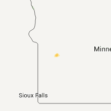


Cities Most Affected by Hail Storms of 8/17/2011
| Hail Size | Demographics of Zip Codes Affected | ||||||
|---|---|---|---|---|---|---|---|
| City | Count | Average | Largest | Pop Density | House Value | Income | Age |
| Belvidere, SD | 2 | 2.63 | 2.75 | 0 | $16k | $22.5k | 46.9 |
| Mullen, NE | 2 | 2.25 | 2.75 | 0 | $41k | $28.7k | 49.6 |
| Winner, SD | 2 | 1.75 | 1.75 | 4 | $55k | $29.0k | 45.4 |
| White River, SD | 1 | 2.75 | 2.75 | 0 | $28k | $24.4k | 35.2 |
| Nenzel, NE | 1 | 2.50 | 2.50 | 0 | $28k | $46.3k | 38.0 |
| Midland, SD | 1 | 2.00 | 2.00 | 0 | $28k | $28.3k | 49.0 |
| Mission, SD | 1 | 1.75 | 1.75 | 1 | $37k | $22.7k | 24.5 |
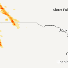
Hail and Wind Damage Spotted on 8/17/2011
Filter by Report Type:Hail ReportsWind Reports
South Dakota
| Local Time | Report Details |
|---|---|
| 4:45 PM MDT | Hen Egg sized hail reported near Midland, SD, 48.7 miles WSW of Pierre, SD |
| 6:02 PM CDT | Golf Ball sized hail reported near Mission, SD, 25.5 miles N of Valentine, NE |
| 6:15 PM CDT | Quarter sized hail reported near White River, SD, 48.3 miles NNW of Valentine, NE |
| 5:25 PM MDT | Tennis Ball sized hail reported near Belvidere, SD, 50.3 miles SW of Pierre, SD |
| 5:37 PM MDT | Baseball sized hail reported near Belvidere, SD, 50.8 miles SW of Pierre, SD, hail causing significant damage to vehicles on interstate 90. |
| 6:55 PM CDT | Baseball sized hail reported near White River, SD, 51.5 miles SW of Pierre, SD, significant damage to roof and windows of house and vehicles |
| 7:12 PM CDT | Quarter sized hail reported near Wood, SD, 37.2 miles N of Valentine, NE |
| 6:15 PM MDT | Quarter sized hail reported near Midland, SD, 44.1 miles WSW of Pierre, SD |
| 7:30 PM CDT | Half Dollar sized hail reported near White River, SD, 49 miles N of Valentine, NE, still hailing at this time |
| 8:12 PM CDT | Quarter sized hail reported near Wood, SD, 37.2 miles N of Valentine, NE |
| 8:15 PM CDT | Quarter sized hail reported near Winner, SD, 29.5 miles NE of Valentine, NE |
| 8:35 PM CDT | Golf Ball sized hail reported near Winner, SD, 29.1 miles NNE of Valentine, NE |
| 8:40 PM CDT | Quarter sized hail reported near Mission, SD, 26.7 miles NNE of Valentine, NE |
| 8:43 PM CDT | Golf Ball sized hail reported near Winner, SD, 33.4 miles NE of Valentine, NE |
| 9:00 PM CDT | Quarter sized hail reported near Winner, SD, 36.2 miles NE of Valentine, NE |
| 9:05 PM CDT | Half Dollar sized hail reported near Winner, SD, 25.6 miles NE of Valentine, NE |
| 2:05 AM UTC | Storm damage reported in tripp county SD, 25.6 miles NE of Valentine, NE |
| 9:22 PM CDT | Quarter sized hail reported near Winner, SD, 20 miles ENE of Valentine, NE |
| 12:30 AM CDT | Quarter sized hail reported near Springfield, SD, 40.8 miles NE of Oneill, NE, also gusty thunderstorm winds from 40 to 45 miles an hour. |
Nebraska
| Local Time | Report Details |
|---|---|
| 5:00 PM MDT | Tennis Ball sized hail reported near Nenzel, NE, 45.7 miles WSW of Valentine, NE |
| 5:21 PM MDT | Half Dollar sized hail reported near Whitman, NE, 59.7 miles WSW of Valentine, NE |
| 6:39 PM MDT | Golf Ball sized hail reported near Mullen, NE, 64.9 miles SSW of Valentine, NE |
| 6:45 PM MDT | Baseball sized hail reported near Mullen, NE, 58.2 miles SW of Valentine, NE |
| 7:25 PM MDT | Quarter sized hail reported near Mullen, NE, 44.7 miles NNW of North Platte, NE |
| 7:35 PM MDT | Quarter sized hail reported near Mullen, NE, 44.7 miles NNW of North Platte, NE |
Texas
| Local Time | Report Details |
|---|---|
| 11:32 PM UTC | 60 mph wind gust reported near montwood and lee trevino streets in east el paso in el paso county TX, 1.5 miles NNE of El Paso, TX |
Kansas
| Local Time | Report Details |
|---|---|
| 11:52 PM UTC | Viola fire department reports at least 60 mile per hour wind in sedgwick county KS, 22 miles SW of Wichita, KS |
| 11:52 PM UTC | Trained spotter estimates 50 to 60 mph wind in sedgwick county KS, 15.4 miles SSW of Wichita, KS |
| 11:55 PM UTC | Clearwater fire department reports at least 60 mph wind in sedgwick county KS, 15.2 miles SW of Wichita, KS |
| 11:55 PM UTC | Storm damage reported in sedgwick county KS, 15.2 miles SW of Wichita, KS |
| 11:58 PM UTC | Viola fire department estimates 65 to 75 mph winds and visibilities reduced to an eighth of a mil in sedgwick county KS, 22 miles SW of Wichita, KS |
| 12:07 AM UTC | Trained spotter estimates 70 mph winds with pea sized hai in sumner county KS, 18.7 miles SSW of Wichita, KS |
| 12:14 AM UTC | Trained spotter estimates at least 70 mph winds and heavy rain with greatly reduced visibilit in sedgwick county KS, 15.4 miles SSW of Wichita, KS |
| 12:16 AM UTC | Wind gusts of at least 70 mph winds having been affecting clearwater for about 15 minutes now. a trained spotter reported a large mature tree uproote in sedgwick county KS, 15.2 miles SW of Wichita, KS |
| 12:36 AM UTC | Trained spotter estimates winds of 70 to 75 mp in sedgwick county KS, 12.3 miles SSE of Wichita, KS |
| 12:37 AM UTC | Storm damage reported in sedgwick county KS, 10.3 miles SSE of Wichita, KS |
| 12:51 AM UTC | Trained spotter estimates 55 to 60 mph wind in butler county KS, 13.9 miles SE of Wichita, KS |
| 12:55 AM UTC | Delayed report that rec center roof was peeled off causing an inch of standing water with the subsequent rai in butler county KS, 13.9 miles SE of Wichita, KS |
| 12:55 AM UTC | Numerous trees and tree limbs were downed on the eastern and southern sides of rose hill...one of which was up to 12 inches in diameter. several fences were blown over in butler county KS, 13.9 miles SE of Wichita, KS |
| 12:55 AM UTC | Tree fell on a residence in rose hill...damaging the homes siding and windows...along with damaging a ca in butler county KS, 13.9 miles SE of Wichita, KS |
| 12:55 AM UTC | Delayed report. two barn roofs were blown off 1 to 2 miles east of rose hil in butler county KS, 15.2 miles ESE of Wichita, KS |
| 1:00 AM UTC | Trained spotter estimates 70 mph winds and had nickel sized hai in butler county KS, 16.1 miles SE of Wichita, KS |
| 1:45 AM UTC | Trained spotter estimates winds up to 60 mp in butler county KS, 31.2 miles ESE of Wichita, KS |
| 1:58 AM UTC | Trained spotter estimates 60 to 65 mph winds and pea sized hai in butler county KS, 37.5 miles ESE of Wichita, KS |
Maryland
| Local Time | Report Details |
|---|---|
| 4:04 AM UTC | Large limbs blown down by tremendous thunderstorm win in baltimore county MD, 27 miles N of Baltimore, MD |
North Dakota
| Local Time | Report Details |
|---|---|
| 1:10 AM CDT | Quarter sized hail reported near Warwick, ND, 28.2 miles S of Devils Lake, ND, heard the hail hitting the side of the house and it woke them up...it sounded big...estimated them to be around the size of quarters. |
Kentucky
| Local Time | Report Details |
|---|---|
| 8:50 AM UTC | One tree down on ky 728 in hart county KY, 45 miles SSW of Louisville, KY |
| 9:31 AM UTC | Three trees down in hart county KY, 57.4 miles S of Louisville, KY |
| 11:14 AM UTC | Emergency management reported several trees downed along state highway 184 in harrison county KY, 50.7 miles NNW of Irvine, KY |
Missouri
| Local Time | Report Details |
|---|---|
| 10:05 AM UTC | Downed tree reported blocking both lanes of highway u three miles east of butterfiel in barry county MO, 43.6 miles SW of Springfield, MO |
Connect with Interactive Hail Maps