

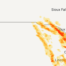
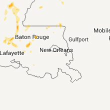
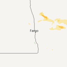
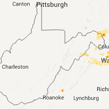
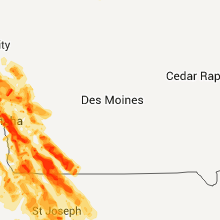
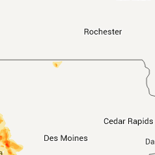
Hail Map for Thursday, August 18, 2011

Number of Impacted Households on 8/18/2011
0
Impacted by 1" or Larger Hail
0
Impacted by 1.75" or Larger Hail
0
Impacted by 2.5" or Larger Hail
Square Miles of Populated Area Impacted on 8/18/2011
0
Impacted by 1" or Larger Hail
0
Impacted by 1.75" or Larger Hail
0
Impacted by 2.5" or Larger Hail


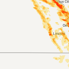


Cities Most Affected by Hail Storms of 8/18/2011
| Hail Size | Demographics of Zip Codes Affected | ||||||
|---|---|---|---|---|---|---|---|
| City | Count | Average | Largest | Pop Density | House Value | Income | Age |
| Omaha, NE | 6 | 2.58 | 4.25 | 5244 | $120k | $36.7k | 31.1 |
| Council Bluffs, IA | 4 | 2.44 | 2.75 | 747 | $79k | $36.6k | 36.3 |
| Bloomfield, NE | 2 | 4.25 | 4.25 | 6 | $36k | $28.1k | 49.6 |
| Allen, NE | 3 | 2.33 | 2.75 | 6 | $55k | $37.2k | 41.0 |
| Ewing, NE | 3 | 2.17 | 2.50 | 2 | $34k | $30.5k | 44.4 |
| Martin, SD | 3 | 2.00 | 2.50 | 1 | $41k | $27.3k | 31.6 |
| Homer, NE | 2 | 2.75 | 3.00 | 4 | $86k | $43.1k | 39.0 |
| Gravity, IA | 2 | 2.25 | 2.75 | 5 | $23k | $29.5k | 47.6 |
| Havre De Grace, MD | 2 | 2.00 | 2.25 | 620 | $138k | $45.5k | 43.3 |
| Saint Helena, NE | 2 | 1.88 | 2.00 | 7 | $67k | $30.8k | 45.3 |
| Manassas, VA | 2 | 1.75 | 1.75 | 1930 | $130k | $53.6k | 30.4 |
| Silver Spring, MD | 2 | 1.75 | 1.75 | 4115 | $199k | $60.4k | 38.0 |
| Tarkio, MO | 2 | 1.75 | 1.75 | 17 | $49k | $30.0k | 46.1 |
| Ponca, NE | 2 | 1.75 | 1.75 | 7 | $73k | $40.0k | 44.9 |
| Maskell, NE | 1 | 2.75 | 2.75 | 400 | $0k | $0.0k | 40.5 |
| Page, NE | 1 | 2.75 | 2.75 | 2 | $40k | $30.6k | 49.2 |
| Stanton, IA | 1 | 2.75 | 2.75 | 9 | $63k | $37.1k | 48.2 |
| Allen, SD | 1 | 2.75 | 2.75 | 0 | $24k | $20.9k | 20.7 |
| Kyle, SD | 1 | 2.75 | 2.75 | 0 | $27k | $23.9k | 24.1 |
| Herman, NE | 1 | 2.50 | 2.50 | 8 | $85k | $40.1k | 42.1 |
| Fort Calhoun, NE | 1 | 2.50 | 2.50 | 58 | $125k | $55.8k | 45.3 |
| Blair, NE | 1 | 2.50 | 2.50 | 91 | $119k | $47.0k | 38.7 |
| Oregon, OH | 1 | 2.00 | 2.00 | 526 | $118k | $45.8k | 42.4 |
| Toledo, OH | 1 | 2.00 | 2.00 | 3555 | $114k | $38.4k | 30.8 |
| Nodaway, IA | 1 | 1.75 | 1.75 | 6 | $24k | $33.8k | 45.5 |
| Cohasset, MN | 1 | 1.75 | 1.75 | 41 | $99k | $45.9k | 45.6 |
| Bel Air, MD | 1 | 1.75 | 1.75 | 945 | $158k | $65.7k | 40.1 |
| Randolph, IA | 1 | 1.75 | 1.75 | 4 | $44k | $45.2k | 49.4 |
| Newcastle, NE | 1 | 1.75 | 1.75 | 3 | $38k | $29.1k | 42.7 |
| Farragut, IA | 1 | 1.75 | 1.75 | 7 | $59k | $35.6k | 49.0 |
| Lesterville, SD | 1 | 1.75 | 1.75 | 4 | $33k | $36.9k | 44.3 |
| Albion, IL | 1 | 1.75 | 1.75 | 34 | $54k | $32.8k | 42.2 |
| Utica, NE | 1 | 1.75 | 1.75 | 11 | $77k | $41.7k | 41.9 |
| Shelby, IA | 1 | 1.75 | 1.75 | 11 | $77k | $37.6k | 42.9 |
| Springfield, SD | 1 | 1.75 | 1.75 | 7 | $61k | $32.9k | 38.8 |
| Conception Junction, MO | 1 | 1.75 | 1.75 | 12 | $46k | $31.5k | 36.4 |
| Greenwood, NE | 1 | 1.75 | 1.75 | 15 | $86k | $46.0k | 41.8 |
| Gayville, SD | 1 | 1.75 | 1.75 | 5 | $56k | $38.8k | 35.7 |
| Danbury, IA | 1 | 1.75 | 1.75 | 5 | $52k | $34.0k | 43.1 |
| Orchard, NE | 1 | 1.75 | 1.75 | 3 | $25k | $23.8k | 48.0 |
| Alvo, NE | 1 | 1.75 | 1.75 | 15 | $71k | $46.0k | 42.3 |
| Waterbury, NE | 1 | 1.75 | 1.75 | 8 | $42k | $33.3k | 41.8 |
| Gettysburg, SD | 1 | 1.75 | 1.75 | 3 | $45k | $31.2k | 49.2 |
| Mantua, OH | 1 | 1.75 | 1.75 | 175 | $139k | $47.5k | 42.3 |
| Chantilly, VA | 1 | 1.75 | 1.75 | 1123 | $245k | $85.9k | 33.1 |
| Natural Bridge, VA | 1 | 1.75 | 1.75 | 27 | $108k | $33.6k | 48.8 |
| Mcintosh, MN | 1 | 1.75 | 1.75 | 9 | $50k | $33.4k | 46.1 |
| Goehner, NE | 1 | 1.75 | 1.75 | 0 | $65k | $42.1k | 41.3 |
| Yankton, SD | 1 | 1.75 | 1.75 | 159 | $82k | $35.4k | 41.1 |
| Oneill, NE | 1 | 1.75 | 1.75 | 9 | $72k | $31.6k | 44.5 |
Hail and Wind Damage Spotted on 8/18/2011
Filter by Report Type:Hail ReportsWind Reports
States Impacted
Tennessee, Missouri, South Dakota, Kansas, Nebraska, Virginia, Mississippi, North Carolina, Pennsylvania, Iowa, Illinois, Texas, New York, Kentucky, Maryland, Louisiana, Indiana, North Dakota, Ohio, Delaware, Arizona, New Jersey, West Virginia, MinnesotaTennessee
| Local Time | Report Details |
|---|---|
| 12:31 PM UTC | Quarter sized hail reported near Memphis, TN, 4.1 miles ESE of Memphis, TN, quarter size hail reported in the midtown memphis area. |
| 8:40 PM UTC | Playhouse blown into road and destroyed. shingles blown off outbuilding. crops blown dow in robertson county TN, 29.1 miles NNW of Nashville, TN |
| 8:40 PM UTC | A tree was blown down along highway 16 in robertson county TN, 30.3 miles N of Nashville, TN |
| 11:45 PM UTC | Storm damage reported in maury county TN, 46.6 miles SSW of Nashville, TN |
| 11:45 PM UTC | One inch hail also reporte in maury county TN, 46.6 miles SSW of Nashville, TN |
| 11:45 PM UTC | Quarter sized hail reported near Columbia, TN, 46.6 miles SSW of Nashville, TN |
| 12:15 AM UTC | Trees down outside of cit in maury county TN, 50.1 miles SSW of Nashville, TN |
| 2:35 AM UTC | Dispatch reported one inch hail and several trees down near alco in blount county TN, 12.2 miles SSW of Knoxville, TN |
| 2:40 AM UTC | Dispatch reported a few trees down near the university of tennessee medical center near knoxvill in knox county TN, 2.8 miles WSW of Knoxville, TN |
| 3:05 AM UTC | Dispatch reported a telephone pole down across wye drive and trees down on walt price road near seviervill in sevier county TN, 16.9 miles ESE of Knoxville, TN |
Missouri
| Local Time | Report Details |
|---|---|
| 1:45 PM UTC | Tree reported down across highway e. time of event estimate in howell county MO, 79.2 miles SSW of Salem, MO |
| 12:05 AM UTC | Numerous trees down in nodaway county MO, 70.4 miles SE of Omaha, NE |
| 12:13 AM UTC | Also reported several large limbs down in worth county MO, 86.4 miles SE of Omaha, NE |
| 12:16 AM UTC | Tree limbs down in nodaway county MO, 80.3 miles SE of Omaha, NE |
| 12:27 AM UTC | Zero visibility reported with the wind in nodaway county MO, 84.8 miles SE of Omaha, NE |
| 12:30 AM UTC | Thunderstorm wind gusts estimated up to 60 mp in nodaway county MO, 84.8 miles SE of Omaha, NE |
| 12:30 AM UTC | Windows blown out of north and west side of house along with quarter sized hai in nodaway county MO, 84.8 miles SE of Omaha, NE |
| 12:35 AM UTC | Half Dollar sized hail reported near Pickering, MO, 80.3 miles SE of Omaha, NE |
| 12:40 AM UTC | Power lines reported down on highway 136. thunderstorm wind gusts were estimated up to 70 mp in nodaway county MO, 78.5 miles N of Kansas City, MO |
| 12:40 AM UTC | Quarter sized hail reported near Clyde, MO, 80.6 miles N of Kansas City, MO, hail covered the ground and stripped most of the leaves off trees in town. power lines were down and power was out. |
| 12:41 AM UTC | Golf Ball sized hail reported near Conception Junction, MO, 80.4 miles N of Kansas City, MO |
| 12:41 AM UTC | Thunderstorm wind gusts estimated up to 70 mp in nodaway county MO, 80.4 miles N of Kansas City, MO |
| 12:48 AM UTC | Wind possibly gusting as high as 90 mph along 136 at the nodaway-gentry county line in gentry county MO, 77.1 miles N of Kansas City, MO |
| 12:53 AM UTC | Quarter sized hail reported near Stanberry, MO, 81.9 miles N of Kansas City, MO |
| 12:54 AM UTC | Barn destroyed in gentry county MO, 77.1 miles N of Kansas City, MO |
| 12:59 AM UTC | Storm damage reported in gentry county MO, 77.1 miles N of Kansas City, MO |
| 1:12 AM UTC | Power poles snapped off in gentry county MO, 72.1 miles NNE of Kansas City, MO |
| 1:18 AM UTC | 2nd story window blown out of a house in daviess county MO, 63.9 miles NNE of Kansas City, MO |
| 1:21 AM UTC | Power poles snapped off in daviess county MO, 75.9 miles NNE of Kansas City, MO |
| 1:31 AM UTC | *** 2 inj *** gas station awning blown down. injuries in a car underneath the awnin in daviess county MO, 58 miles NNE of Kansas City, MO |
| 1:36 AM UTC | Roof damage and 40 foot tower blown over in daviess county MO, 58 miles NNE of Kansas City, MO |
| 1:52 AM UTC | Quarter sized hail reported near Holton, MO, 60 miles SSE of Omaha, NE |
| 1:54 AM UTC | Golf Ball sized hail reported near Tarkio, MO, 63.8 miles SSE of Omaha, NE |
| 1:58 AM UTC | Golf Ball sized hail reported near Tarkio, MO, 63.8 miles SSE of Omaha, NE |
| 2:03 AM UTC | Power lines and trees reported down. thunderstorm wind gusts estimated up to 60 mp in atchison county MO, 63.8 miles SSE of Omaha, NE |
| 2:03 AM UTC | Quarter sized hail reported near Fairfax, MO, 69.8 miles SSE of Omaha, NE |
| 2:04 AM UTC | Quarter sized hail reported near Tarkio, MO, 63.8 miles SSE of Omaha, NE |
| 2:12 AM UTC | Trees down in atchison county MO, 71.1 miles SSE of Omaha, NE |
| 2:34 AM UTC | North facing windows of benedictine sister convent blow in nodaway county MO, 80.6 miles N of Kansas City, MO |
| 2:40 AM UTC | Storm damage reported in holt county MO, 68.4 miles NNW of Kansas City, MO |
| 3:04 AM UTC | Two trees down in gentry county MO, 77.1 miles N of Kansas City, MO |
| 3:14 AM UTC | Missouri highway patrol tower blown down in buchanan county MO, 50.1 miles NNW of Kansas City, MO |
| 3:22 AM UTC | Storm damage reported in buchanan county MO, 48.8 miles NNW of Kansas City, MO |
| 10:23 PM CDT | Quarter sized hail reported near St Joseph, MO, 47.5 miles NNW of Kansas City, MO |
| 10:25 PM CDT | Quarter sized hail reported near St Joseph, MO, 48.2 miles NNW of Kansas City, MO |
| 3:31 AM UTC | Thunderstorm wind gusts were estimated up to 70 mp in buchanan county MO, 47.9 miles NNW of Kansas City, MO |
| 3:47 AM UTC | Thunderstorm wind gusts estimated up to 60 mp in clinton county MO, 47.6 miles NNE of Kansas City, MO |
| 3:50 AM UTC | Quarter sized hail reported near Dearborn, MO, 30.5 miles NNW of Kansas City, MO |
| 3:51 AM UTC | Semi-tractor trailer truck jack-knifed in andrew county MO, 62.5 miles NNW of Kansas City, MO |
| 3:54 AM UTC | Storm damage reported in clinton county MO, 39.7 miles N of Kansas City, MO |
| 4:01 AM UTC | Half Dollar sized hail reported near Edgerton, MO, 25.6 miles N of Kansas City, MO |
| 4:03 AM UTC | Blew gas grill 30 feet across deck in platte county MO, 9.3 miles NNW of Kansas City, MO |
| 4:07 AM UTC | Ping Pong Ball sized hail reported near Liberty, MO, 14.5 miles NE of Kansas City, MO |
| 4:12 AM UTC | Storm damage reported in clay county MO, 6.9 miles NNE of Kansas City, MO |
| 4:12 AM UTC | Estimated 70 mph in platte county MO, 24.1 miles N of Kansas City, MO |
| 4:12 AM UTC | Storm damage reported in platte county MO, 9 miles NNW of Kansas City, MO |
| 4:14 AM UTC | Numerous in clay county MO, 1.5 miles NW of Kansas City, MO |
| 4:18 AM UTC | Storm damage reported in clinton county MO, 25.3 miles N of Kansas City, MO |
| 4:20 AM UTC | Storm damage reported in caldwell county MO, 53.9 miles NE of Kansas City, MO |
| 4:25 AM UTC | Storm damage reported in jackson county MO, 8.8 miles E of Kansas City, MO |
| 11:25 PM CDT | Quarter sized hail reported near Glenaire, MO, 10.8 miles NE of Kansas City, MO |
| 4:31 AM UTC | Estimated 60-65 mph...also quarter size hail in clay county MO, 7.5 miles N of Kansas City, MO |
| 4:31 AM UTC | A few trees down in warrensburg in johnson county MO, 51.7 miles ESE of Kansas City, MO |
| 4:45 AM UTC | Storm damage reported in jackson county MO, 6.4 miles S of Kansas City, MO |
| 4:48 AM UTC | Storm damage reported in caldwell county MO, 53.7 miles NE of Kansas City, MO |
| 5:00 AM UTC | Thunderstorm wind gusts were estimated up to 60 mph. 2 to 3 inch tree limbs were snapped of in ray county MO, 35.1 miles ENE of Kansas City, MO |
| 5:08 AM UTC | Storm damage reported in lafayette county MO, 38.7 miles E of Kansas City, MO |
| 5:15 AM UTC | 18-20 inch tree blown down in johnson county MO, 46.4 miles ESE of Kansas City, MO |
| 5:33 AM UTC | 18-20 inch diameter tree in johnson county MO, 51.7 miles ESE of Kansas City, MO |
| 5:35 AM UTC | Storm damage reported in johnson county MO, 47.4 miles ESE of Kansas City, MO |
| 5:45 AM UTC | Pickup truck blown over on highway 50 in pettis county MO, 61.1 miles WSW of Columbia, MO |
| 5:45 AM UTC | Pickup truck blown over on highway 50 in pettis county MO, 60.9 miles WSW of Columbia, MO |
| 5:57 AM UTC | Storm damage reported in johnson county MO, 61.3 miles ESE of Kansas City, MO |
| 5:57 AM UTC | Storm damage reported in pettis county MO, 53.2 miles WSW of Columbia, MO |
| 5:58 AM UTC | Numerous tents and power lines blown down at state fair ground in mercer county MO, 73.4 miles S of Des Moines, IA |
| 5:58 AM UTC | Numerous tents and power lines blown down at state fair ground in pettis county MO, 52.4 miles WSW of Columbia, MO |
| 6:10 AM UTC | Estimated by ambulance crew. relayed to county law enforcemen in benton county MO, 55.5 miles WSW of Columbia, MO |
| 6:15 AM UTC | Storm damage reported in pettis county MO, 56.5 miles WSW of Columbia, MO |
| 6:20 AM UTC | Powerline down....time estd in bates county MO, 48.5 miles S of Kansas City, MO |
| 6:38 AM UTC | 3-4 inch diameter tree limbs down...time estd in bates county MO, 59.7 miles SSE of Kansas City, MO |
| 6:55 AM UTC | Report from volunteer weather observe in morgan county MO, 51.8 miles SSW of Columbia, MO |
| 7:00 AM UTC | Tree down blocking road on hwy w. reported from miller county 91 in miller county MO, 50.6 miles SSW of Columbia, MO |
| 7:10 AM UTC | Report from miller county 91 in miller county MO, 50.3 miles S of Columbia, MO |
| 7:50 AM UTC | Small tree blown down on main street. tree has since been remove in osage county MO, 42.1 miles SE of Columbia, MO |
South Dakota
| Local Time | Report Details |
|---|---|
| 4:40 PM UTC | Strong thunderstorm winds downed large tree branches near mart in charles mix county SD, 37.9 miles NNE of Oneill, NE |
| 5:30 PM UTC | Quarter sized hail reported near Springfield, SD, 40.8 miles NE of Oneill, NE, also gusty thunderstorm winds from 40 to 45 miles an hour. |
| 5:35 PM UTC | Golf Ball sized hail reported near Springfield, SD, 40.8 miles NE of Oneill, NE |
| 7:12 PM UTC | Quarter sized hail reported near Springfield, SD, 40.8 miles NE of Oneill, NE, also gusty thunderstorm winds from 40 to 45 miles an hour. |
| 7:20 PM UTC | Quarter sized hail reported near Scotland, SD, 56.8 miles WSW of Sioux Falls, SD |
| 7:30 PM UTC | Golf Ball sized hail reported near Lesterville, SD, 53.1 miles SW of Sioux Falls, SD |
| 8:09 PM UTC | Half Dollar sized hail reported near Yankton, SD, 52.3 miles SW of Sioux Falls, SD, 1.5 inches of rain in 20 minutes. |
| 8:15 PM UTC | Quarter sized hail reported near Yankton, SD, 56.1 miles SW of Sioux Falls, SD |
| 8:15 PM UTC | Storm damage reported in yankton county SD, 56.1 miles SW of Sioux Falls, SD |
| 8:20 PM UTC | Golf Ball sized hail reported near Yankton, SD, 56.1 miles SW of Sioux Falls, SD, hail broke out windows at wnax radio. |
| 8:43 PM UTC | Quarter sized hail reported near Gayville, SD, 55.6 miles SSW of Sioux Falls, SD, lots of hail covering the ground |
| 9:11 PM UTC | Quarter sized hail reported near McLaughlin, SD, 60.5 miles S of Bismarck, ND, quarter to nickel hail. |
| 9:45 PM UTC | Ping Pong Ball sized hail reported near Scotland, SD, 58.6 miles WSW of Sioux Falls, SD |
| 9:48 PM UTC | Quarter sized hail reported near McLaughlin, SD, 73 miles SSW of Bismarck, ND |
| 10:11 PM UTC | Quarter sized hail reported near McLaughlin, SD, 77 miles S of Bismarck, ND, at least quarter sized hail. hail drifting on front porch. |
| 10:25 PM UTC | Storm damage reported in yankton county SD, 56.1 miles SW of Sioux Falls, SD |
| 10:29 PM UTC | Quarter sized hail reported near Mission Hill, SD, 51.3 miles SSW of Sioux Falls, SD |
| 10:29 PM UTC | Quarter sized hail reported near Yankton, SD, 56.1 miles SW of Sioux Falls, SD |
| 10:35 PM UTC | Baseball sized hail reported near Kyle, SD, 64.5 miles SE of Rapid City, SD, hail lasted form 5 minutes. mostly golf ball size hail. |
| 10:48 PM UTC | Golf Ball sized hail reported near Gayville, SD, 55.6 miles SSW of Sioux Falls, SD |
| 11:05 PM UTC | Quarter sized hail reported near Mobridge, SD, 85 miles N of Pierre, SD, quarter hail reported along highway 1804 at walworth campbell coutny line |
| 11:10 PM UTC | Baseball sized hail reported near Allen, SD, 74.7 miles WNW of Valentine, NE |
| 11:22 PM UTC | Golf Ball sized hail reported near Martin, SD, 73.8 miles WNW of Valentine, NE |
| 11:24 PM UTC | Tennis Ball sized hail reported near Martin, SD, 67 miles WNW of Valentine, NE, golfball to tennis ball size hail. |
| 11:26 PM UTC | Ping Pong Ball sized hail reported near Martin, SD, 63.8 miles WNW of Valentine, NE |
| 11:26 PM UTC | Golf Ball sized hail reported near Martin, SD, 63.1 miles WNW of Valentine, NE, reported by sheriff. |
| 11:30 PM UTC | Quarter sized hail reported near Glenham, SD, 78.3 miles N of Pierre, SD |
| 11:55 PM UTC | Ping Pong Ball sized hail reported near , , 61.4 miles W of Valentine, NE |
| 12:00 AM UTC | Quarter sized hail reported near Avon, SD, 45.3 miles NE of Oneill, NE |
| 12:05 AM UTC | Golf Ball sized hail reported near Gettysburg, SD, 57.4 miles NNE of Pierre, SD |
| 12:06 AM UTC | Quarter sized hail reported near Avon, SD, 42.8 miles NE of Oneill, NE |
Kansas
| Local Time | Report Details |
|---|---|
| 4:41 PM UTC | Quarter sized hail reported near Lawrence, KS, 38.8 miles WSW of Kansas City, MO |
| 11:42 PM UTC | Quarter sized hail reported near Wellington, KS, 44 miles S of Wichita, KS, law enforcement reports quarter sized hail east of the turnpike on us highway 166. |
| 2:49 AM UTC | Spotter estimated 55-65 mph wind in brown county KS, 75.2 miles NW of Kansas City, MO |
| 3:03 AM UTC | Aprs mesonet site...measured 66 mph wind gust in brown county KS, 63.7 miles NW of Kansas City, MO |
| 3:15 AM UTC | Law enforcement estimates winds of 50 to 60 mp in brown county KS, 66.3 miles NW of Kansas City, MO |
| 3:23 AM UTC | Storm damage reported in doniphan county KS, 49.4 miles NNW of Kansas City, MO |
| 3:45 AM UTC | Tree down on car in holton on hwy 16 in jackson county KS, 48.4 miles ENE of Manhattan, KS |
| 3:55 AM UTC | Small building destroyed and power lines down in the town of valley falls in jefferson county KS, 49.8 miles WNW of Kansas City, MO |
| 3:55 AM UTC | Tree blown across road...several 3 inch brances down in jackson county KS, 51.4 miles E of Manhattan, KS |
| 4:02 AM UTC | 60 mph winds and 2.09 inches of rain in jefferson county KS, 49.1 miles W of Kansas City, MO |
| 4:02 AM UTC | Storm damage reported in shawnee county KS, 51.1 miles E of Manhattan, KS |
| 4:05 AM UTC | Storm damage reported in shawnee county KS, 51.1 miles E of Manhattan, KS |
| 4:06 AM UTC | Storm damage reported in shawnee county KS, 38.1 miles E of Manhattan, KS |
| 4:06 AM UTC | Thunderstorm wind gusts estimated up to 65 mph. tree limbs reported dow in leavenworth county KS, 25.7 miles W of Kansas City, MO |
| 4:06 AM UTC | Widespread tree damage in oakland area in northeast topeka. numerous branches greater than 8 inches in diameter broken off...with some trees uprooted. one tree landed o in shawnee county KS, 50.1 miles E of Manhattan, KS |
| 4:08 AM UTC | Mobile home lost 3/4 of the roof on holy cross r in pottawatomie county KS, 28.4 miles ENE of Manhattan, KS |
| 4:08 AM UTC | Trees down and most of the town without powe in pottawatomie county KS, 26.4 miles E of Manhattan, KS |
| 4:08 AM UTC | Reports of roof damage to homes. also widespread reports of trees and powerlines down across the count in shawnee county KS, 53.5 miles E of Manhattan, KS |
| 4:10 AM UTC | Storm damage reported in shawnee county KS, 50.3 miles ESE of Manhattan, KS |
| 4:13 AM UTC | Estimated 60 mph near washburn university in shawnee county KS, 48.1 miles ESE of Manhattan, KS |
| 4:13 AM UTC | Power lines down at 7th and iowa in lawrence in douglas county KS, 37.7 miles WSW of Kansas City, MO |
| 4:14 AM UTC | Estimated 60 mph winds with blown transformers around tow in douglas county KS, 37.7 miles WSW of Kansas City, MO |
| 4:15 AM UTC | Raws mesonet site...time estimated in jackson county KS, 41.1 miles ENE of Manhattan, KS |
| 4:15 AM UTC | Half of roof blown off house. many trees blown dow in shawnee county KS, 53.5 miles E of Manhattan, KS |
| 4:15 AM UTC | Shed blown over in shawnee county KS, 49.4 miles E of Manhattan, KS |
| 4:15 AM UTC | Many trees down along second stree from croco road to tecumseh in shawnee county KS, 52.4 miles E of Manhattan, KS |
| 4:15 AM UTC | Semi-trailer truck blown over on interstate 7 in wabaunsee county KS, 29.7 miles ESE of Manhattan, KS |
| 4:18 AM UTC | 7 inch diameter limb broken from strong winds in shawnee county KS, 34 miles E of Manhattan, KS |
| 4:23 AM UTC | Ixd asos measured thunderstorm wind gust at 59 mp in johnson county KS, 19.1 miles SW of Kansas City, MO |
| 4:25 AM UTC | Storm damage reported in shawnee county KS, 50.3 miles ESE of Manhattan, KS |
| 4:25 AM UTC | Two large semi-trailers blown over. time estimate in shawnee county KS, 53.5 miles W of Kansas City, MO |
| 4:32 AM UTC | Thunderstorm wind gusts estimated up to 60 mp in johnson county KS, 19.1 miles SW of Kansas City, MO |
| 4:33 AM UTC | Storm damage reported in leavenworth county KS, 18.8 miles W of Kansas City, MO |
| 4:33 AM UTC | 5 inch tree limbs down with estimated winds of 60-70 mp in douglas county KS, 41.8 miles WSW of Kansas City, MO |
| 4:33 AM UTC | 5 inch tree limbs with estimated gusts of 60-70 mp in douglas county KS, 41.8 miles WSW of Kansas City, MO |
| 4:34 AM UTC | Ixd asos measured thunderstorm wind gust at 68 mp in johnson county KS, 19.1 miles SW of Kansas City, MO |
| 4:38 AM UTC | At 580 am wibw studio in shawnee county KS, 43.5 miles ESE of Manhattan, KS |
| 4:39 AM UTC | Tree blown down. time estimate in pottawatomie county KS, 13.6 miles E of Manhattan, KS |
| 4:39 AM UTC | Part of roof of house blown off. time estimate in pottawatomie county KS, 27.9 miles ENE of Manhattan, KS |
| 4:40 AM UTC | At menninger hill. also pea size hai in shawnee county KS, 43.5 miles ESE of Manhattan, KS |
| 4:41 AM UTC | Quarter sized hail reported near Lawrence, KS, 38.8 miles WSW of Kansas City, MO |
| 4:43 AM UTC | Storm damage reported in johnson county KS, 23.5 miles WSW of Kansas City, MO |
| 4:44 AM UTC | Storm damage reported in johnson county KS, 24.7 miles SSW of Kansas City, MO |
| 4:45 AM UTC | At wolf creek power plant in coffey county KS, 39.5 miles NNW of Chanute, KS |
| 4:45 AM UTC | Damage to roof with estimated winds of 60-65 mp in osage county KS, 56.9 miles ESE of Manhattan, KS |
| 4:49 AM UTC | Storm damage reported in johnson county KS, 18.4 miles SSW of Kansas City, MO |
| 4:49 AM UTC | 3 inch limbs down and street sign blown over at 10th and i-7 in shawnee county KS, 49.3 miles E of Manhattan, KS |
| 4:50 AM UTC | Reports of 4 inch tree limbs down with half inch sized hai in shawnee county KS, 49 miles ESE of Manhattan, KS |
| 4:57 AM UTC | 3 to 4 inch tree limbs dow in osage county KS, 48.9 miles SE of Manhattan, KS |
| 5:02 AM UTC | Trees and powerlines reported down across the city of ottaw in franklin county KS, 49.8 miles SW of Kansas City, MO |
| 5:05 AM UTC | 4-5 inch tree limbs downed in linn county KS, 37.1 miles NE of Chanute, KS |
| 5:37 AM UTC | 4-5 inch tree limbs downed in miami county KS, 33 miles S of Kansas City, MO |
| 5:38 AM UTC | Storm damage reported in anderson county KS, 42.8 miles NNE of Chanute, KS |
| 5:45 AM UTC | At wolf creek power plant in coffey county KS, 39.5 miles NNW of Chanute, KS |
| 6:05 AM UTC | 4-5 inch tree limbs downed in linn county KS, 37.1 miles NE of Chanute, KS |
| 8:35 AM UTC | Power poles blown down in kingman county KS, 59.7 miles WSW of Wichita, KS |
Nebraska
| Local Time | Report Details |
|---|---|
| 5:45 PM UTC | Quarter sized hail reported near Niobrara, NE, 37.4 miles ENE of Oneill, NE, quarter size hail...and lots of it. |
| 1:07 PM CDT | Grapefruit sized hail reported near Bloomfield, NE, 53.5 miles ENE of Oneill, NE, hail up to softball size broke out windshield in windrower. |
| 1:10 PM CDT | Grapefruit sized hail reported near Bloomfield, NE, 57.8 miles ENE of Oneill, NE, hail up to softball size |
| 6:13 PM UTC | 50 to 60 mph in bloomfiel in knox county NE, 51.9 miles ENE of Oneill, NE |
| 8:30 PM UTC | Golf Ball sized hail reported near St Helena, NE, 56.3 miles SSW of Sioux Falls, SD, wind estimated 60mph. |
| 8:58 PM UTC | Golf Ball sized hail reported near Obert, NE, 60.9 miles SSW of Sioux Falls, SD, all windows on the west side of house were broken...winds estimated at 60 mph |
| 9:08 PM UTC | Baseball sized hail reported near Maskell, NE, 62.8 miles S of Sioux Falls, SD, hail through roof of home |
| 9:23 PM UTC | Half Dollar sized hail reported near Anoka, NE, 35.2 miles NNW of Oneill, NE |
| 9:25 PM UTC | Ping Pong Ball sized hail reported near Pierce, NE, 58.4 miles E of Oneill, NE |
| 9:28 PM UTC | Ping Pong Ball sized hail reported near Newcastle, NE, 62.2 miles S of Sioux Falls, SD |
| 9:28 PM UTC | Golf Ball sized hail reported near Ponca, NE, 67.7 miles S of Sioux Falls, SD |
| 9:31 PM UTC | Quarter sized hail reported near Herman, NE, 31.1 miles NNW of Omaha, NE |
| 9:31 PM UTC | Tennis Ball sized hail reported near Herman, NE, 31.8 miles NNW of Omaha, NE |
| 9:35 PM UTC | Golf Ball sized hail reported near Ponca, NE, 69.4 miles S of Sioux Falls, SD |
| 9:42 PM UTC | Tennis Ball sized hail reported near Allen, NE, 75 miles S of Sioux Falls, SD |
| 9:43 PM UTC | Quarter sized hail reported near Inman, NE, 11 miles SE of Oneill, NE, hail falling at the time of the report. |
| 9:43 PM UTC | Golf Ball sized hail reported near Waterbury, NE, 74.9 miles S of Sioux Falls, SD, strong winds associated with this storm. the wind and hail knocked many windows out of buildings and power was out. |
| 9:51 PM UTC | Tennis Ball sized hail reported near Blair, NE, 21.9 miles NNW of Omaha, NE, hail between golf ball and tea cup size also 50 to 60 mph winds. |
| 10:01 PM UTC | Hen Egg sized hail reported near Ewing, NE, 19.6 miles SE of Oneill, NE |
| 5:01 PM CDT | Tennis Ball sized hail reported near Fort Calhoun, NE, 16.2 miles NNW of Omaha, NE, winds estimated at 70 mph. |
| 10:09 PM UTC | Hen Egg sized hail reported near Ewing, NE, 21.7 miles SE of Oneill, NE |
| 5:10 PM CDT | Golf Ball sized hail reported near Omaha, NE, 3.6 miles W of Omaha, NE, up to golfball size hail near 40th street and north post road. |
| 5:12 PM CDT | Baseball sized hail reported near Omaha, NE, 3.6 miles W of Omaha, NE, up to softball size hail at interstate 680 and 48th street |
| 10:13 PM UTC | Ping Pong Ball sized hail reported near Oneill, NE, 22.1 miles NNE of Oneill, NE |
| 10:13 PM UTC | Tennis Ball sized hail reported near Ewing, NE, 20.4 miles SE of Oneill, NE, golf ball to tennis ball size hail along highway 45b. |
| 5:16 PM CDT | Tennis Ball sized hail reported near Homer, NE, 69.6 miles WSW of Storm Lake, IA |
| 5:18 PM CDT | Golf Ball sized hail reported near Omaha, NE, 3.9 miles WNW of Omaha, NE |
| 5:20 PM CDT | Tea Cup sized hail reported near Homer, NE, 69.6 miles WSW of Storm Lake, IA |
| 5:22 PM CDT | Storm damage reported in douglas county NE, 3.6 miles W of Omaha, NE |
| 5:24 PM CDT | Tea Cup sized hail reported near Omaha, NE, 3.6 miles W of Omaha, NE, at least one broken window in florence area. |
| 5:25 PM CDT | Hen Egg sized hail reported near Omaha, NE, 3.6 miles W of Omaha, NE, hail up to 2 inch diamter in koma observation |
| 5:25 PM CDT | Grapefruit sized hail reported near Omaha, NE, 3.6 miles W of Omaha, NE, *** 1 inj *** hail up to softball size at eppley airfield. relayed by news media. pilot hit by hailstone. |
| 5:30 PM CDT | Quarter sized hail reported near Omaha, NE, 3.6 miles W of Omaha, NE, up to one inch hail on interstate 480 bridge downtown omaha. |
| 10:30 PM UTC | Baseball sized hail reported near Martinsburg, NE, 71.6 miles S of Sioux Falls, SD |
| 10:30 PM UTC | Tree dow in dixon county NE, 71.5 miles S of Sioux Falls, SD |
| 10:30 PM UTC | Tree down on bar in dixon county NE, 71.5 miles S of Sioux Falls, SD |
| 10:33 PM UTC | Golf Ball sized hail reported near Allen, NE, 74.3 miles S of Sioux Falls, SD, *** 1 inj *** windows broken out of car. semi tipped over due to hail and fog with driver taken to hospital for minor injuries. |
| 10:43 PM UTC | Hen Egg sized hail reported near St Helena, NE, 57.1 miles SSW of Sioux Falls, SD |
| 10:45 PM UTC | Golf Ball sized hail reported near Oneill, NE, 14.1 miles NE of Oneill, NE |
| 10:52 PM UTC | Quarter sized hail reported near Allen, NE, 70.8 miles S of Sioux Falls, SD |
| 11:06 PM UTC | Baseball sized hail reported near Page, NE, 13.2 miles E of Oneill, NE |
| 11:20 PM UTC | Golf Ball sized hail reported near Orchard, NE, 20.9 miles E of Oneill, NE |
| 11:44 PM UTC | Storm damage reported in burt county NE, 38.7 miles NNW of Omaha, NE |
| 11:45 PM UTC | Quarter sized hail reported near Oakdale, NE, 43.9 miles SE of Oneill, NE, lasted 15 minutes. |
| 11:55 PM UTC | Ping Pong Ball sized hail reported near Merriman, NE, 60.8 miles W of Valentine, NE |
| 12:22 AM UTC | Quarter sized hail reported near Wahoo, NE, 35.5 miles W of Omaha, NE, mostly pea sized with some nickel and quarter sized. |
| 7:28 PM CDT | Near 163rd and for in douglas county NE, 3.6 miles W of Omaha, NE |
| 7:30 PM CDT | Thunderstorm wind gust at eppley airfield in douglas county NE, 3.6 miles W of Omaha, NE |
| 12:40 AM UTC | Winds estimated up to 60 mph by react spotter in sarpy county NE, 7 miles S of Omaha, NE |
| 7:40 PM CDT | Winds estimated up to 65 mph near interstate 680 at irvingto in douglas county NE, 3.6 miles W of Omaha, NE |
| 12:40 AM UTC | Estimated 80 mph wind near 163rd and for in douglas county NE, 13.7 miles WNW of Omaha, NE |
| 12:49 AM UTC | Cars blown onto road shoulders in cass county NE, 22.3 miles S of Omaha, NE |
| 12:52 AM UTC | Ping Pong Ball sized hail reported near Newman Grove, NE, 64 miles NNE of Grand Island, NE |
| 1:00 AM UTC | Storm damage reported in cass county NE, 33.3 miles SW of Omaha, NE |
| 8:00 PM CDT | Trees down in gallagher park near 52nd and mapl in douglas county NE, 3.6 miles W of Omaha, NE |
| 1:03 AM UTC | 3 inch tree limbs dow in cass county NE, 33.3 miles SW of Omaha, NE |
| 1:05 AM UTC | Golf Ball sized hail reported near Greenwood, NE, 33.3 miles SW of Omaha, NE |
| 1:10 AM UTC | Winds estimated up to 60 mph in platte county NE, 58.2 miles NE of Grand Island, NE |
| 1:11 AM UTC | Golf Ball sized hail reported near Alvo, NE, 35.7 miles SW of Omaha, NE |
| 1:20 AM UTC | Quarter sized hail reported near Elmwood, NE, 34.3 miles SSW of Omaha, NE |
| 1:30 AM UTC | Quarter sized hail reported near Genoa, NE, 41.8 miles NE of Grand Island, NE, strong winds also record on highway 22 between genoa and fullerton |
| 1:38 AM UTC | Numerous 5 inch diameter branches down in polk county NE, 53.6 miles ENE of Grand Island, NE |
| 2:30 AM UTC | Tree down in the town of aubur in nemaha county NE, 60.3 miles S of Omaha, NE |
| 2:31 AM UTC | Golf Ball sized hail reported near Utica, NE, 54.6 miles E of Grand Island, NE, hail up to golfball size |
| 2:32 AM UTC | Quarter sized hail reported near Goehner, NE, 59 miles E of Grand Island, NE |
| 2:34 AM UTC | Ping Pong Ball sized hail reported near Milford, NE, 63.3 miles E of Grand Island, NE |
| 2:36 AM UTC | Golf Ball sized hail reported near Goehner, NE, 59 miles E of Grand Island, NE, hail up to golfball size |
| 2:40 AM UTC | Quarter sized hail reported near Lincoln, NE, 49.6 miles SW of Omaha, NE, nickel to quarter size hail northwest side of lincoln |
| 2:44 AM UTC | Quarter sized hail reported near Lincoln, NE, 57.7 miles WSW of Omaha, NE |
| 2:49 AM UTC | Quarter sized hail reported near Dorchester, NE, 67.2 miles ESE of Grand Island, NE, hail up to one inch diameter. lasted 3 minutes |
| 2:58 AM UTC | Two trees blown down and some tree limbs blown dow in richardson county NE, 80.1 miles NE of Manhattan, KS |
| 3:08 AM UTC | Quarter sized hail reported near Wilber, NE, 75.9 miles SW of Omaha, NE, hailed a couple of times through around twenty two after the hour. |
| 3:12 AM UTC | Ping Pong Ball sized hail reported near Wilber, NE, 76.1 miles SW of Omaha, NE |
| 4:14 AM UTC | Quarter sized hail reported near Norfolk, NE, 60.1 miles ESE of Oneill, NE |
Virginia
| Local Time | Report Details |
|---|---|
| 6:20 PM UTC | A tree was blown down along interstate highway 81 near the town of drape in pulaski county VA, 50.5 miles WSW of Roanoke, VA |
| 6:25 PM UTC | Tree down on lee highway in the draper mountain area in pulaski county VA, 50.2 miles WSW of Roanoke, VA |
| 6:40 PM UTC | Quarter sized hail reported near Roanoke, VA, 2.1 miles NW of Roanoke, VA |
| 8:02 PM UTC | Few trees down in max meadows. fire dept dispatche in wythe county VA, 59.2 miles WSW of Roanoke, VA |
| 8:25 PM UTC | Quarter sized hail reported near Bent Mountain, VA, 14.3 miles SW of Roanoke, VA |
| 8:40 PM UTC | Quarter sized hail reported near Austinville, VA, 59.8 miles WSW of Roanoke, VA, quarter size hail was observed on lead mine road just west of interstate 77. |
| 8:46 PM UTC | Quarter sized hail reported near Huddleston, VA, 31.4 miles E of Roanoke, VA, quarter size hail along johnson mountain road. |
| 8:56 PM UTC | Dispatch reported one inch hail in coebur in wise county VA, 28.3 miles NNW of Bristol, TN |
| 9:24 PM UTC | Quarter sized hail reported near Fairfax, VA, 46.7 miles SW of Baltimore, MD |
| 9:50 PM UTC | Golf Ball sized hail reported near Natural Bridge, VA, 33.1 miles NE of Roanoke, VA, hail ranging from dime to golfball size from 520 pm to 550 pm |
| 9:55 PM UTC | Quarter sized hail reported near , , 47 miles WSW of Baltimore, MD |
| 6:00 PM EDT | 2 inch diameter limbs snapped off of softwood trees in fairfax county VA, 46.9 miles WSW of Baltimore, MD |
| 10:07 PM UTC | Quarter sized hail reported near Sterling, VA, 47.6 miles WSW of Baltimore, MD |
| 10:13 PM UTC | Quarter sized hail reported near Lexington, VA, 41 miles NE of Roanoke, VA, quarter size hail south of the city of lexington |
| 7:10 PM EDT | Quarter sized hail reported near Gainesville, VA, 61.2 miles WSW of Baltimore, MD |
| 7:26 PM EDT | Ping Pong Ball sized hail reported near Catharpin, VA, 59.4 miles WSW of Baltimore, MD, hail ranged from one-half inch to the size of ping pong balls |
| 7:30 PM EDT | Golf Ball sized hail reported near Manassas, VA, 58.4 miles WSW of Baltimore, MD, hail was oblate |
| 11:33 PM UTC | Quarter sized hail reported near Bentonville, VA, 85.9 miles E of Elkins, WV |
| 7:40 PM EDT | Golf Ball sized hail reported near Manassas, VA, 58.9 miles WSW of Baltimore, MD |
| 11:54 PM UTC | Tree down near intersection of fravel road and spring hollow road in shenandoah county VA, 70.9 miles E of Elkins, WV |
| 8:00 PM EDT | Golf Ball sized hail reported near Chantilly, VA, 54.8 miles WSW of Baltimore, MD |
| 1:20 AM UTC | Quarter sized hail reported near Ashburn, VA, 51.8 miles WSW of Baltimore, MD |
| 2:32 AM UTC | Trees down on rock mills rd in rappahannock county VA, 84.1 miles NNW of Richmond, VA |
| 2:34 AM UTC | Trees down on richmond rd in rappahannock county VA, 86.9 miles NNW of Richmond, VA |
| 2:54 AM UTC | Quarter sized hail reported near Rixeyville, VA, 78.8 miles NNW of Richmond, VA |
| 2:56 AM UTC | Large tree limbs broken in thunderstorm wind in culpeper county VA, 78.8 miles NNW of Richmond, VA |
Mississippi
| Local Time | Report Details |
|---|---|
| 6:21 PM UTC | Power lines down in the city in madison county MS, 11.2 miles NNE of Jackson, MS |
| 6:25 PM UTC | Fence blown down...power line down and numerous large limbs blown down in madison county MS, 8.9 miles NNE of Jackson, MS |
| 6:27 PM UTC | Measured at the reservoir tower in madison county MS, 10 miles NE of Jackson, MS |
| 6:33 PM UTC | 5 trees down across roads...1 tree down on the roof of a house. another house was damaged from the wind and a power line was dow in madison county MS, 11.2 miles NNE of Jackson, MS |
| 6:33 PM UTC | Large tree limbs downed along spillway road and two large trees downed at highland bluff elementary schoo in rankin county MS, 9.1 miles ENE of Jackson, MS |
| 6:33 PM UTC | Large tree limbs downed along spillway road east of the hidden hills subdivision and two large trees downed at highland block elementary schoo in rankin county MS, 9.1 miles ENE of Jackson, MS |
| 6:40 PM UTC | Estimated at the ross barnett reservoir tower. a power pole was broken...power poles were leaning and a nearby tree was snappe in madison county MS, 10 miles NE of Jackson, MS |
| 6:40 PM UTC | Measured at the ross barnett reservoir tower. some damage reported at the tower in madison county MS, 10 miles NE of Jackson, MS |
| 6:46 PM UTC | Reported at spillway road and northshore parkway in rankin county MS, 9.9 miles NE of Jackson, MS |
| 6:50 PM UTC | Measured at brandon eoc in rankin county MS, 10.6 miles E of Jackson, MS |
| 7:05 PM UTC | Measured at brandon eoc in rankin county MS, 10.6 miles E of Jackson, MS |
| 7:05 PM UTC | Estimated 60 to 70 mph winds in rankin county MS, 10.6 miles E of Jackson, MS |
| 7:05 PM UTC | Tree down and shingles off apartment roofs in rankin county MS, 10.6 miles E of Jackson, MS |
| 7:30 PM UTC | Tree down in the city in copiah county MS, 23.7 miles SSW of Jackson, MS |
| 7:45 PM UTC | Trees down across hwy 13...poplar springs road...and hwy 540 in simpson county MS, 29.6 miles SE of Jackson, MS |
| 8:15 PM UTC | A very large tree fell on a shed and a 4 wheeler in copiah county MS, 43 miles SW of Jackson, MS |
| 8:49 PM UTC | A few trees down along lily rose rd in jefferson davis county MS, 55.5 miles SSE of Jackson, MS |
| 8:53 PM UTC | A few trees were down along williamsburg rd in jefferson davis county MS, 60.8 miles SSE of Jackson, MS |
| 9:25 PM UTC | Trees down around kokom in marion county MS, 76.4 miles S of Jackson, MS |
| 9:27 PM UTC | Power line down on a house along williams cutoff in marion county MS, 71.9 miles SSE of Jackson, MS |
| 9:32 PM UTC | Thunderstorm wind gust downed a tree near the intersection of highways 583 and 33 in walthall county MS, 77.8 miles S of Jackson, MS |
North Carolina
| Local Time | Report Details |
|---|---|
| 6:57 PM UTC | Quarter sized hail reported near Lowgap, NC, 72.7 miles SW of Roanoke, VA, quarter size hail from 242 pm to 257 pm |
| 8:15 PM UTC | Quarter sized hail reported near Purlear, NC, 54.1 miles ESE of Bristol, TN, quarter hail at 1042 buck mountain rd |
| 8:21 PM UTC | Tree down in wilkes county NC, 69.4 miles N of Charlotte, NC |
| 8:42 PM UTC | Two trees down. one on route 268 east and the other on peacock stree in wilkes county NC, 68.6 miles N of Charlotte, NC |
| 8:45 PM UTC | A spotter reported that several large limbs were blown dow in wilkes county NC, 71.4 miles N of Charlotte, NC |
| 9:30 PM UTC | Quarter sized hail reported near Taylorsville, NC, 51.8 miles NNW of Charlotte, NC |
| 9:30 PM UTC | 20 trees down. hiddenite f.d. repor in alexander county NC, 51.8 miles NNW of Charlotte, NC |
| 9:30 PM UTC | Trees down all over the county. many reports of large hail...not sure on the actual siz in alexander county NC, 51.8 miles NNW of Charlotte, NC |
| 9:30 PM UTC | Four mobile homes blown off their foundations on taylorsville manufactoring roa in alexander county NC, 51.4 miles NNW of Charlotte, NC |
| 10:12 PM UTC | Large maple limbs dow in catawba county NC, 41.7 miles NNW of Charlotte, NC |
| 10:17 PM UTC | Tree across sulpher springs rd in catawba county NC, 45.8 miles NNW of Charlotte, NC |
| 10:19 PM UTC | Power line snapped 17th st nw in catawba county NC, 46.6 miles NW of Charlotte, NC |
| 10:21 PM UTC | Large oak tree blocking old catawba rd and another tree fell on a vehicl in catawba county NC, 37.2 miles NNW of Charlotte, NC |
| 10:28 PM UTC | Trees blocking road near highway 70/oxford school r in catawba county NC, 36.9 miles NNW of Charlotte, NC |
Pennsylvania
| Local Time | Report Details |
|---|---|
| 7:04 PM UTC | Quarter sized hail reported near Damascus, PA, 36.6 miles NE of Scranton, PA, hail covered the ground 4 inchs deep |
| 6:40 PM EDT | Quarter sized hail reported near Newtown, PA, 59.4 miles WSW of Brooklyn, NY |
| 7:00 PM EDT | Tree limbs dow in chester county PA, 54.5 miles NE of Baltimore, MD |
| 7:00 PM EDT | Half Dollar sized hail reported near New Garden, PA, 56.1 miles NE of Baltimore, MD |
| 7:40 PM EDT | Quarter sized hail reported near Upper Chichester, PA, 72.7 miles ENE of Baltimore, MD |
| 12:02 AM UTC | Storm damage reported in philadelphia county PA, 83.3 miles ENE of Baltimore, MD |
| 12:05 AM UTC | Trees dow in montgomery county PA, 82.4 miles WSW of Brooklyn, NY |
| 12:20 AM UTC | Trees dow in montgomery county PA, 75.9 miles WSW of Brooklyn, NY |
| 8:20 PM EDT | Trees dow in montgomery county PA, 74.4 miles WSW of Brooklyn, NY |
| 8:25 PM EDT | Trees dow in montgomery county PA, 71.5 miles WSW of Brooklyn, NY |
| 8:25 PM EDT | Quarter sized hail reported near Upper Dublin, PA, 73.9 miles WSW of Brooklyn, NY |
| 2:00 AM UTC | Quarter sized hail reported near Gettysburg, PA, 49.8 miles NW of Baltimore, MD, reported at the 911 center |
Iowa
| Local Time | Report Details |
|---|---|
| 7:16 PM UTC | Storm damage reported in monona county IA, 44.6 miles SW of Storm Lake, IA |
| 7:23 PM UTC | Golf Ball sized hail reported near Danbury, IA, 38.7 miles SW of Storm Lake, IA |
| 9:00 PM UTC | 65 mph wind one mile north and one mile west harlan. also farm damaged about 5 miles northwest of harlan where grain bins and outbuildings were destroyed. a one thousan in shelby county IA, 41.6 miles NE of Omaha, NE |
| 9:12 PM UTC | Golf Ball sized hail reported near Tennant, IA, 35 miles NE of Omaha, NE |
| 9:40 PM UTC | Quarter sized hail reported near Hancock, IA, 31.5 miles ENE of Omaha, NE, hail lasted 10 minutes. |
| 9:49 PM UTC | Quarter sized hail reported near Modale, IA, 24 miles NNW of Omaha, NE |
| 5:26 PM CDT | Golf Ball sized hail reported near Council Bluffs, IA, 4.4 miles ESE of Omaha, NE |
| 5:28 PM CDT | Baseball sized hail reported near Council Bluffs, IA, 4.4 miles ESE of Omaha, NE, winds estimated at 60 mph |
| 5:32 PM CDT | Baseball sized hail reported near Council Bluffs, IA, 5.4 miles ESE of Omaha, NE |
| 5:37 PM CDT | Tennis Ball sized hail reported near Council Bluffs, IA, 4.4 miles ESE of Omaha, NE, hail up to tennis ball size at lake manawa exit. time estimated between 530 pm and 545 pm. |
| 10:54 PM UTC | Half Dollar sized hail reported near Onawa, IA, 53.7 miles N of Omaha, NE |
| 10:55 PM UTC | Storm damage reported in montgomery county IA, 41.4 miles ESE of Omaha, NE |
| 11:03 PM UTC | Quarter sized hail reported near Villisca, IA, 53.5 miles ESE of Omaha, NE, winds estimated at 70 mph. |
| 11:03 PM UTC | Quarter sized hail reported near Stanton, IA, 49.8 miles ESE of Omaha, NE, wind estimated at 70 mph. |
| 11:03 PM UTC | Baseball sized hail reported near Stanton, IA, 49.8 miles ESE of Omaha, NE |
| 11:15 PM UTC | Golf Ball sized hail reported near Nodaway, IA, 58.6 miles ESE of Omaha, NE |
| 11:34 PM UTC | Estimated 60 mph winds and penny sized hail in taylor county IA, 68.7 miles ESE of Omaha, NE |
| 11:39 PM UTC | Baseball sized hail reported near Gravity, IA, 71.6 miles ESE of Omaha, NE, golf ball to baseball sized hail |
| 11:40 PM UTC | Golf Ball sized hail reported near Gravity, IA, 71.6 miles ESE of Omaha, NE |
| 11:40 PM UTC | The roof was ripped off of a gas station at hw 2 and 148 and blown 100 yards. many trees 2 to 3 feet in diameter uprooted or snapped off at their base...some lying on v in taylor county IA, 75.7 miles ESE of Omaha, NE |
| 11:40 PM UTC | Tree limbs up to 12 inches in diameter and power lines down along a line from bedford to gravity. extensive tree damage along hw 2 around bedford and a roof blown off o in taylor county IA, 75.7 miles ESE of Omaha, NE |
| 11:44 PM UTC | Quarter sized hail reported near Woodbine, IA, 35.2 miles NNE of Omaha, NE, hail up to quarter size |
| 11:55 PM UTC | Quarter sized hail reported near Conway, IA, 77.5 miles ESE of Omaha, NE, hail covering the ground |
| 11:57 PM UTC | Quarter sized hail reported near Harlan, IA, 42 miles NE of Omaha, NE |
| 11:59 PM UTC | Quarter sized hail reported near Bedford, IA, 75.7 miles ESE of Omaha, NE |
| 12:00 AM UTC | 15 inch diameter trees down...numerous north facing windows broken in town. power lines down. winds estimated 70 mph plus also one inch hail. north side of braddyvill in page county IA, 66.1 miles SE of Omaha, NE |
| 12:00 AM UTC | Trees and power lines down. winds estimated 70 mph plus also one inch hail. north side of braddyville in page county IA, 66.1 miles SE of Omaha, NE |
| 12:06 AM UTC | Quarter sized hail reported near Blockton, IA, 81.6 miles SW of Des Moines, IA |
| 12:33 AM UTC | Quarter sized hail reported near Underwood, IA, 16.2 miles ENE of Omaha, NE |
| 12:53 AM UTC | Quarter sized hail reported near Glenwood, IA, 17.9 miles SE of Omaha, NE, pea to quarter size. |
| 1:13 AM UTC | Golf Ball sized hail reported near Randolph, IA, 33.5 miles SE of Omaha, NE |
| 8:33 PM CDT | Quarter sized hail reported near Farragut, IA, 44.4 miles SSE of Omaha, NE |
| 8:33 PM CDT | Golf Ball sized hail reported near Farragut, IA, 44.4 miles SSE of Omaha, NE, delayed report. |
| 1:55 AM UTC | Storm damage reported in page county IA, 59.2 miles SE of Omaha, NE |
| 2:16 AM UTC | Tree limbs down outside the fire station. winds estimated at 60 mp in taylor county IA, 65.6 miles ESE of Omaha, NE |
Illinois
| Local Time | Report Details |
|---|---|
| 7:45 PM UTC | Storm damage reported in pope county IL, 47.5 miles E of Cape Girardeau, MO |
| 8:55 PM UTC | Golf Ball sized hail reported near Albion, IL, 40.8 miles NW of Evansville, IN, between west salem and bone gap |
| 9:04 PM UTC | Wind measured at aso in jackson county IL, 33.9 miles NNE of Cape Girardeau, MO |
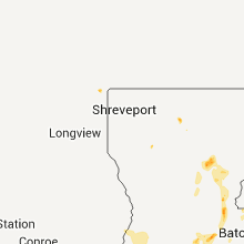
Texas
| Local Time | Report Details |
|---|---|
| 7:45 PM UTC | A home in karnack had significant roof damag in harrison county TX, 27.7 miles WNW of Shreveport, LA |
| 10:08 PM UTC | Quarter sized hail reported near Dickinson, TX, 46.5 miles WSW of Baltimore, MD |
New York
| Local Time | Report Details |
|---|---|
| 7:55 PM UTC | Tree down across road in niagara county NY, 27.6 miles NE of Buffalo, NY |
| 7:33 PM EDT | Power lines down near high school in richmond county NY, 5.9 miles SW of Brooklyn, NY |
| 12:08 AM UTC | Downed power lines in cedarhurst on the rockaway turnpik in nassau county NY, 14.3 miles ESE of Brooklyn, NY |
| 8:24 PM EDT | One tree down in rockville centre. time estimated by rada in nassau county NY, 18.5 miles E of Brooklyn, NY |
| 8:33 PM EDT | Power lines down on dutch broadwa in nassau county NY, 14.7 miles E of Brooklyn, NY |
| 8:35 PM EDT | Wires down on raymond plac in nassau county NY, 14.7 miles ESE of Brooklyn, NY |
| 8:39 PM EDT | Downed power lines on rockaway avenu in nassau county NY, 18.9 miles ESE of Brooklyn, NY |
| 8:46 PM EDT | Wires down on north wantagh avenue in nassau county NY, 25.3 miles E of Brooklyn, NY |
| 1:23 AM UTC | Power lines down on broadway avenue in suffolk county NY, 40.5 miles E of Brooklyn, NY |
| 1:42 AM UTC | Power lines down on lincoln avenue in suffolk county NY, 47.4 miles E of Brooklyn, NY |
| 1:45 AM UTC | Quarter sized hail reported near Patchogue, NY, 51.2 miles E of Brooklyn, NY, quarter size hail in patchogue |
| 1:46 AM UTC | Power lines down on mulford stree in suffolk county NY, 51.3 miles E of Brooklyn, NY |
| 1:47 AM UTC | Large tree limbs down on cedar avenue in suffolk county NY, 51.2 miles E of Brooklyn, NY |
Kentucky
| Local Time | Report Details |
|---|---|
| 8:00 PM UTC | Time estimated. roof blown off of barn near intersection of highland road and cty hwy 848. reported via law enforcemen in todd county KY, 39.8 miles NNW of Nashville, TN |
| 8:02 PM UTC | Trees down and some damage to a bar in logan county KY, 42.3 miles NNW of Nashville, TN |
| 8:02 PM UTC | Update to previous report from olmstead. some vehicle damage and minor damage to homes in the area. some trees on road in logan county KY, 42.3 miles NNW of Nashville, TN |
| 8:15 PM UTC | Time estimated. numerous trees down near the community of allensvill in todd county KY, 40.6 miles NNW of Nashville, TN |
| 8:55 PM UTC | Golf Ball sized hail reported near Eighty Eight, KY, 39.8 miles NW of Evansville, IN, between west salem and bone gap |
| 10:46 PM UTC | Quarter sized hail reported near Bonnieville, KY, 40.9 miles S of Louisville, KY |
| 12:00 AM UTC | Dispatch relayed report of trees blocking roadway in henry county KY, 48.2 miles NE of Louisville, KY |
| 12:03 AM UTC | Power line dow in marion county KY, 38.5 miles SE of Louisville, KY |
Maryland
| Local Time | Report Details |
|---|---|
| 8:16 PM UTC | Tree down partially blocking oak manor driv in anne arundel county MD, 10.4 miles S of Baltimore, MD |
| 8:27 PM UTC | Tree down partially blocking oak manor driv in anne arundel county MD, 10.4 miles S of Baltimore, MD |
| 8:46 PM UTC | Quarter sized hail reported near Fort Meade, MD, 13.4 miles SSW of Baltimore, MD, quarter size hail in fort meade... md |
| 9:08 PM UTC | Estimated wind gusts of 60 mph in anne arundel county MD, 13.4 miles SSW of Baltimore, MD |
| 9:15 PM UTC | Tree 1 to 1.5 feet in diameter blown down by thunderstorm wind gus in anne arundel county MD, 13.4 miles SSW of Baltimore, MD |
| 5:26 PM EDT | Tree down blocking roadway near patterson mill road and route 92 in harford county MD, 21.3 miles NE of Baltimore, MD |
| 9:26 PM UTC | Quarter sized hail reported near Mt Airy, MD, 28.9 miles WNW of Baltimore, MD, hail ranged from penny to quarter size |
| 9:34 PM UTC | Quarter sized hail reported near Bel Air, MD, 23.9 miles NE of Baltimore, MD, at md-543 and redfield road |
| 5:34 PM EDT | Golf Ball sized hail reported near Bel Air, MD, 22 miles NE of Baltimore, MD, some hail up to golf ball size |
| 5:36 PM EDT | Tree down at md-543 and calvary road in harford county MD, 23.7 miles NE of Baltimore, MD |
| 9:40 PM UTC | Tree was blown down onto garage crushing the roof...a car in the garage was damaged when the tree fell. also...multiple 150 year old trees blown dow in anne arundel county MD, 18.8 miles SSW of Baltimore, MD |
| 9:40 PM UTC | Quarter sized hail reported near Aberdeen, MD, 24.9 miles NE of Baltimore, MD |
| 9:43 PM UTC | Tree dow in harford county MD, 21.8 miles NNE of Baltimore, MD |
| 9:47 PM UTC | Wires dow in harford county MD, 23.2 miles NNE of Baltimore, MD |
| 5:48 PM EDT | Hen Egg sized hail reported near Havre de Grace, MD, 30 miles NE of Baltimore, MD |
| 6:00 PM EDT | Golf Ball sized hail reported near Havre de Grace, MD, 33 miles NE of Baltimore, MD, golf ball hail at steppingstone museum. |
| 10:01 PM UTC | Quarter sized hail reported near Havre de Grace, MD, 32.1 miles NE of Baltimore, MD, hail ranged from pea to quarter size |
| 10:05 PM UTC | Quarter sized hail reported near Port Deposit, MD, 33.8 miles NE of Baltimore, MD |
| 10:10 PM UTC | Quarter sized hail reported near Perryville, MD, 34.7 miles NE of Baltimore, MD |
| 10:12 PM UTC | Quarter sized hail reported near Reisterstown, MD, 18.9 miles NNW of Baltimore, MD |
| 6:15 PM EDT | Quarter sized hail reported near Kensington, MD, 29.7 miles SW of Baltimore, MD, quarter size hail was oblong in shape and deposited on the ground in white patches near intersection of viers mill rd and university blvd. |
| 6:15 PM EDT | Half Dollar sized hail reported near Kensington, MD, 29.7 miles SW of Baltimore, MD |
| 6:19 PM EDT | Quarter sized hail reported near Silver Spring, MD, 29.8 miles SW of Baltimore, MD, quarter size hail at intersection of connecticut ave and viers mill road. |
| 10:20 PM UTC | Tree 1 to 1.5 feet in diameter blown down by thunderstorm wind gus in anne arundel county MD, 13.4 miles SSW of Baltimore, MD |
| 6:20 PM EDT | Ping Pong Ball sized hail reported near Silver Spring, MD, 29.3 miles SW of Baltimore, MD, hail resulted in dense hail fog. |
| 10:24 PM UTC | Quarter sized hail reported near Silver Spring, MD, 28.6 miles WSW of Baltimore, MD |
| 6:33 PM EDT | Golf Ball sized hail reported near Silver Spring, MD, 24.2 miles SW of Baltimore, MD |
| 6:35 PM EDT | Golf Ball sized hail reported near Silver Spring, MD, 23.8 miles SW of Baltimore, MD |
| 10:38 PM UTC | Quarter sized hail reported near Silver Spring, MD, 23.3 miles SW of Baltimore, MD |
| 10:45 PM UTC | Quarter sized hail reported near Beltsville, MD, 23.5 miles SW of Baltimore, MD |
| 6:47 PM EDT | Ping Pong Ball sized hail reported near Laurel, MD, 18.8 miles SW of Baltimore, MD |
| 10:52 PM UTC | Quarter sized hail reported near Laurel, MD, 17 miles SW of Baltimore, MD |
| 11:00 PM UTC | Quarter sized hail reported near Glen Burnie, MD, 10.1 miles SSE of Baltimore, MD |
| 11:07 PM UTC | Quarter sized hail reported near Severn, MD, 12.8 miles SSW of Baltimore, MD |
| 11:09 PM UTC | Quarter sized hail reported near Severn, MD, 12 miles SSW of Baltimore, MD |
| 11:20 PM UTC | Quarter sized hail reported near Glen Burnie, MD, 8.3 miles S of Baltimore, MD |
| 1:48 AM UTC | Quarter sized hail reported near Clear Spring, MD, 75.6 miles WNW of Baltimore, MD, also trees and large limbs down near clear spring high school. |
| 2:15 AM UTC | Multiple reports of trees down in eastern parts of washington count in washington county MD, 62.8 miles WNW of Baltimore, MD |
| 2:44 AM UTC | Several sycamore trees snapped off in thunderstorm wind in washington county MD, 60.6 miles WNW of Baltimore, MD |
| 2:45 AM UTC | Quarter sized hail reported near Boonsboro, MD, 60.6 miles WNW of Baltimore, MD |
| 4:04 AM UTC | Large limbs blown down by tremendous thunderstorm win in baltimore county MD, 27 miles N of Baltimore, MD |
Louisiana
| Local Time | Report Details |
|---|---|
| 8:35 PM UTC | Numerous trees and powerlines were downed from a downburst which occurred in the martin area along hwy 507 and 786. trees and powerlines were also downed 2 miles north in red river county LA, 42.1 miles SE of Shreveport, LA |
| 8:50 PM UTC | Several trees were snapped and uprooted in the spring ridge are in caddo county LA, 17.9 miles SW of Shreveport, LA |
| 9:15 PM UTC | Tree limbs and power lines down in lincoln county LA, 45.6 miles WSW of Bastrop, LA |
| 9:25 PM UTC | Several trees and power lines are dow in sabine county LA, 50.7 miles S of Shreveport, LA |
| 10:53 PM UTC | Several trees down in the summerville are in la salle county LA, 69.5 miles S of Bastrop, LA |
| 1:21 AM UTC | Tree down on two vehicles and power lines down on house at dunbar st. in opelousas in st. landry county LA, 21 miles N of Lafayette, LA |
| 1:25 AM UTC | Quarter sized hail reported near Opelousas, LA, 22.6 miles NNW of Lafayette, LA, public reports quarter size hail tree branches blown down and blown transformers |
| 1:54 AM UTC | Lafayette asos measured a wind gust of 72 mph in lafayette county LA, 0.8 miles W of Lafayette, LA |
| 2:00 AM UTC | Public estimates wind gust of 75 mph. power outages also reported on thruwa in lafayette county LA, 0.8 miles W of Lafayette, LA |
| 2:02 AM UTC | Public estimates wind gust of 60-75 mph. report also indicated that a pine cone flew through and broke a house windo in lafayette county LA, 0.8 miles W of Lafayette, LA |
| 3:40 AM UTC | Tree fell on house at 2809 creole st. in lake charle in calcasieu county LA, 33.1 miles ENE of Beaumont, TX |
Indiana
| Local Time | Report Details |
|---|---|
| 9:14 PM UTC | Quarter sized hail reported near Elnora, IN, 62.6 miles NNE of Evansville, IN, quarter size hail fell for approximately five minutes 1.5 ssw of the north daviess high school. late report...time approximated from radar. |
| 11:55 PM UTC | Trees dow in perry county IN, 47.3 miles ENE of Evansville, IN |
North Dakota
| Local Time | Report Details |
|---|---|
| 9:45 PM UTC | Quarter sized hail reported near Fort Yates, ND, 58.5 miles S of Bismarck, ND, late report from public through emergency management. |
Ohio
| Local Time | Report Details |
|---|---|
| 10:20 PM UTC | Half Dollar sized hail reported near Toledo, OH, 88.7 miles ENE of Fort Wayne, IN, trained spotters reported half dollar size hail in the toledo area. |
| 10:22 PM UTC | Quarter sized hail reported near Toledo, OH, 88.7 miles ENE of Fort Wayne, IN, numerous reports of quarter size hail. |
| 10:22 PM UTC | Ping Pong Ball sized hail reported near Toledo, OH, 88.7 miles ENE of Fort Wayne, IN, trained spotters reported ping pong ball size hail lasting several minutes in the toledo area. |
| 10:26 PM UTC | Hen Egg sized hail reported near Toledo, OH, 88.7 miles ENE of Fort Wayne, IN, trained spotters reported 2.00in hail lasting several minutes. |
| 11:07 PM UTC | Quarter sized hail reported near Toledo, OH, 89.3 miles ENE of Fort Wayne, IN, trained spotters reported quarter size hail. |
| 11:20 PM UTC | Quarter sized hail reported near Toledo, OH, 88.7 miles ENE of Fort Wayne, IN, public reported quarter size hail. |
| 11:30 PM UTC | A few large tree limbs dow in lucas county OH, 89.3 miles ENE of Fort Wayne, IN |
| 11:52 PM UTC | Quarter sized hail reported near Oregon, OH, 90.3 miles W of Cleveland, OH, trained spotters reported quarter size hail. |
| 11:55 PM UTC | Ping Pong Ball sized hail reported near Oregon, OH, 90.3 miles W of Cleveland, OH, trained spotter reported half dollar to ping pong ball size hail. |
| 12:02 AM UTC | Hen Egg sized hail reported near Oregon, OH, 90.3 miles W of Cleveland, OH, trained spotter reported ping pong ball to hen egg size hail lasting several minutes. |
| 12:03 AM UTC | Quarter sized hail reported near Northwood, OH, 91.9 miles ENE of Fort Wayne, IN, trained spotter reported quarter size hail. |
| 8:00 AM UTC | Quarter sized hail reported near Macedonia, OH, 16.7 miles SE of Cleveland, OH |
| 8:00 AM UTC | Quarter sized hail reported near Northfield, OH, 14.1 miles SE of Cleveland, OH |
| 8:07 AM UTC | Quarter sized hail reported near Aurora, OH, 22.6 miles SE of Cleveland, OH |
| 8:35 AM UTC | Quarter sized hail reported near Mantua, OH, 28.9 miles ESE of Cleveland, OH |
| 8:35 AM UTC | Quarter sized hail reported near Novelty, OH, 18.2 miles E of Cleveland, OH |
| 8:50 AM UTC | Golf Ball sized hail reported near Mantua, OH, 28.9 miles ESE of Cleveland, OH |
| 10:00 AM UTC | Quarter sized hail reported near Windham, OH, 38.4 miles ESE of Cleveland, OH |
| 10:20 AM UTC | Quarter sized hail reported near Newton Falls, OH, 43.3 miles ESE of Cleveland, OH |
Delaware
| Local Time | Report Details |
|---|---|
| 11:00 PM UTC | Tree limbs dow in new castle county DE, 59.6 miles NE of Baltimore, MD |
| 7:40 PM EDT | Quarter sized hail reported near Claymont, DE, 70.7 miles ENE of Baltimore, MD |
| 7:45 PM EDT | Quarter sized hail reported near Claymont, DE, 70.7 miles ENE of Baltimore, MD |
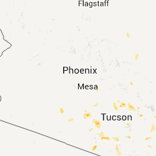
Arizona
| Local Time | Report Details |
|---|---|
| 11:30 PM UTC | 11 power poles down in pima county AZ, 57.3 miles WSW of Tucson, AZ |
| 11:50 PM UTC | 60 mph. winds. 1 ft. diameter trees blown down. roof blown off of house. 1/4 in. hai in pinal county AZ, 36.3 miles ESE of Phoenix, AZ |
| 11:54 PM UTC | Approximately 30 power poles blown down in the johnson ranch area along hunt highway near judd roa in pinal county AZ, 38.7 miles ESE of Phoenix, AZ |
| 11:59 PM UTC | Power lines down at bella vista and gantzel...at least one power line fell on a school bu in pinal county AZ, 35 miles ESE of Phoenix, AZ |
| 1:30 AM UTC | Reported at zuni hills elementary school in maricopa county AZ, 19.8 miles NW of Phoenix, AZ |
| 1:30 AM UTC | Reported at zuni hills elementary school in maricopa county AZ, 20.7 miles NW of Phoenix, AZ |
New Jersey
| Local Time | Report Details |
|---|---|
| 8:10 PM EDT | Quarter sized hail reported near Westville, NJ, 82.7 miles SW of Brooklyn, NY |
| 8:20 PM EDT | Trees and wires dow in burlington county NJ, 73.6 miles SW of Brooklyn, NY |
| 8:25 PM EDT | Trees and wires dow in burlington county NJ, 70.7 miles SW of Brooklyn, NY |
| 9:50 PM EDT | Trees dow in morris county NJ, 36.5 miles W of Brooklyn, NY |
| 10:00 PM EDT | Trees dow in morris county NJ, 31.3 miles WNW of Brooklyn, NY |
| 10:20 PM EDT | Trees dow in cumberland county NJ, 74.5 miles E of Baltimore, MD |
| 2:34 AM UTC | Tree down blocking ringwood road at stiles cour in passaic county NJ, 26.4 miles NW of Brooklyn, NY |
| 2:38 AM UTC | Tree down into a house on legion street in passaic county NJ, 26.4 miles NW of Brooklyn, NY |
| 2:40 AM UTC | Power lines down on butler stree in passaic county NJ, 26.4 miles NW of Brooklyn, NY |
| 2:54 AM UTC | Multiple trees down across the city in bergen county NJ, 26 miles NNW of Brooklyn, NY |
West Virginia
| Local Time | Report Details |
|---|---|
| 12:31 AM UTC | Quarter sized hail reported near Falling Waters, WV, 69.7 miles WNW of Baltimore, MD |
| 2:05 AM UTC | Quarter sized hail reported near Falling Waters, WV, 73.1 miles WNW of Baltimore, MD |
| 2:20 AM UTC | Quarter sized hail reported near Falling Waters, WV, 69.7 miles WNW of Baltimore, MD |
Minnesota
| Local Time | Report Details |
|---|---|
| 5:25 AM UTC | Quarter sized hail reported near Red Lake Falls, MN, 69.9 miles SSW of Roseau, MN, mainly dime to nickel hail with a few quarter sized. hail lasted through 1228 am cdt. |
| 5:45 AM UTC | Quarter sized hail reported near Mentor, MN, 61.1 miles WNW of Bemidji, MN |
| 5:55 AM UTC | Quarter sized hail reported near , , 53.8 miles WNW of Bemidji, MN, lots of nickel and quarter hail. |
| 6:05 AM UTC | Golf Ball sized hail reported near McIntosh, MN, 48.3 miles WNW of Bemidji, MN |
| 6:20 AM UTC | Quarter sized hail reported near Ponsford, MN, 31.9 miles SW of Bemidji, MN, hail still in gutters at sunrise |
| 6:25 AM UTC | Quarter sized hail reported near Fosston, MN, 38.8 miles W of Bemidji, MN |
| 6:40 AM UTC | Quarter sized hail reported near Bemidji, MN, 8.9 miles NW of Bemidji, MN, lots of quarter sized hail along hwy 89. |
| 6:40 AM UTC | Quarter sized hail reported near Bemidji, MN, 7.9 miles NW of Bemidji, MN, lots of quarter sized hail along hwy 89. |
| 7:00 AM UTC | Very strong winds and ping pong ball sized hai in beltrami county MN, 0.9 miles ESE of Bemidji, MN |
| 7:00 AM UTC | Ping Pong Ball sized hail reported near Bemidji, MN, 0.9 miles ESE of Bemidji, MN |
| 7:04 AM UTC | Large trees blown down along south side of lake bemidj in beltrami county MN, 2.8 miles SE of Bemidji, MN |
| 7:09 AM UTC | Via amateur radio... some siding blown off of the pamida store south of lake bemidj in beltrami county MN, 2.7 miles SSE of Bemidji, MN |
| 7:20 AM UTC | Numerous trees blown down and power poles snapped along roosevelt road and around northern cass lak in beltrami county MN, 18.7 miles E of Bemidji, MN |
| 7:25 AM UTC | Eastward extension of wind damage path from beltrami county along roosevelt r in cass county MN, 16.7 miles ESE of Bemidji, MN |
| 7:25 AM UTC | Quarter sized hail reported near Remer, MN, 53.8 miles ESE of Bemidji, MN |
| 7:28 AM UTC | Reports of power poles snapped and power lines down in the nymor area of southeast bemidj in beltrami county MN, 3.6 miles SE of Bemidji, MN |
| 8:02 AM UTC | Golf Ball sized hail reported near Cohasset, MN, 57 miles ESE of Bemidji, MN |
Connect with Interactive Hail Maps