

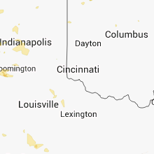
Hail Map for Tuesday, August 19, 2014

Number of Impacted Households on 8/19/2014
0
Impacted by 1" or Larger Hail
0
Impacted by 1.75" or Larger Hail
0
Impacted by 2.5" or Larger Hail
Square Miles of Populated Area Impacted on 8/19/2014
0
Impacted by 1" or Larger Hail
0
Impacted by 1.75" or Larger Hail
0
Impacted by 2.5" or Larger Hail


Cities Most Affected by Hail Storms of 8/19/2014
| Hail Size | Demographics of Zip Codes Affected | ||||||
|---|---|---|---|---|---|---|---|
| City | Count | Average | Largest | Pop Density | House Value | Income | Age |
| Fredericktown, MO | 3 | 1.75 | 1.75 | 30 | $56k | $26.0k | 40.7 |
| Millersville, MO | 1 | 2.75 | 2.75 | 24 | $88k | $34.9k | 43.4 |
| De Soto, IA | 1 | 1.75 | 1.75 | 120 | $88k | $48.9k | 34.7 |
Hail and Wind Damage Spotted on 8/19/2014
Filter by Report Type:Hail ReportsWind Reports
States Impacted
Georgia, Missouri, Indiana, South Carolina, Florida, Alabama, Michigan, Nevada, Arizona, Kentucky, Ohio, Arkansas, Texas, Washington, IowaGeorgia
| Local Time | Report Details |
|---|---|
| 11:44 AM EDT | Tree down on college avenue in tattnall county GA, 58.9 miles NE of Douglas, GA |
| 12:42 PM EDT | Large tree down on john wells roa in liberty county GA, 40 miles WSW of Savannah, GA |
| 12:45 PM EDT | Large limb knocked down which is blocking the entrance to a business and is on a power lin in liberty county GA, 33.9 miles WSW of Savannah, GA |
| 12:45 PM EDT | Tree fell on power lines at the 1500 block of georgia highway 57 in front of smiley elementary schoo in long county GA, 45.8 miles SW of Savannah, GA |
| 1:05 PM EDT | Tree down across a power line at the intersection of limrick road and north coastal highwa in liberty county GA, 25.9 miles SW of Savannah, GA |
| 1:13 PM EDT | Large tree down on a home on parkview road. no one was home at the tim in chatham county GA, 8.9 miles WSW of Savannah, GA |
| 1:16 PM EDT | Tree down on powerline at the intersection of godsells street and mildred stree in chatham county GA, 3.9 miles SSW of Savannah, GA |
| 1:20 PM EDT | Tree down on bona bella avenue in between skidaway road and jan stree in chatham county GA, 4.9 miles S of Savannah, GA |
| 1:22 PM EDT | Tree fell on house on georgia avenu in chatham county GA, 2.8 miles SE of Savannah, GA |
| 1:32 PM EDT | Tree fell on power line at brickhaven roa in chatham county GA, 8.6 miles SE of Savannah, GA |
| 1:32 PM EDT | Tree down at baytree rd and norman drive in lowndes county GA, 53.1 miles SSW of Douglas, GA |
| 2:35 PM EDT | Large tree down on ga-151 north of morga in calhoun county GA, 81.8 miles NNW of Tallahassee, FL |
| 3:10 PM EDT | Powerlines down on the 1800 block of schley avenu in dougherty county GA, 79.5 miles W of Douglas, GA |
| 3:25 PM EDT | Tree down on ga-112 blocking one lane of traffic. time estimated by rada in mitchell county GA, 68.2 miles NNE of Tallahassee, FL |
| 3:45 PM EDT | Charlton county 911/dispatch reports a tree downed near the intersection of orange and lincoln streets in the town of homeland. time of damage based on radar dat in charlton county GA, 42.4 miles NNW of Jacksonville, FL |
| 4:01 PM EDT | Power pole reported down in omega. time estimated by rada in tift county GA, 45.8 miles WSW of Douglas, GA |
| 4:45 PM EDT | Several trees down south of nashville. time estimated by rada in berrien county GA, 33.6 miles SW of Douglas, GA |
Missouri
| Local Time | Report Details |
|---|---|
| 12:11 PM CDT | Golf Ball sized hail reported near Fredericktown, MO, 45.2 miles WNW of Cape Girardeau, MO, fredericktown police department reports golf ball size hail in fredericktown. |
| 12:13 PM CDT | Golf Ball sized hail reported near Fredericktown, MO, 44.9 miles WNW of Cape Girardeau, MO |
| 12:14 PM CDT | Golf Ball sized hail reported near Fredericktown, MO, 45.2 miles WNW of Cape Girardeau, MO |
| 2:45 PM CDT | Baseball sized hail reported near Millersville, MO, 21.7 miles WNW of Cape Girardeau, MO, baseball size hail reported in the community. near the intersection of hwys b and m. |
Indiana
| Local Time | Report Details |
|---|---|
| 12:45 PM CDT | Measured gust to 58 mph at gary airpor in lake county IN, 24.8 miles SE of Chicago, IL |
| 3:05 PM EDT | Trees and powerlines down near cleveland road in st. joseph county IN, 72.8 miles E of Chicago, IL |
| 3:26 PM EDT | There were 3 telephone poles snapped over railroad tracks...time estimated by radar in kosciusko county IN, 44.4 miles WNW of Fort Wayne, IN |
| 3:59 PM EDT | Trees down on e 175 n in lagrange county IN, 42.9 miles NNW of Fort Wayne, IN |
| 4:01 PM EDT | Sycamore tree snapped halfway up in noble county IN, 34.4 miles NNW of Fort Wayne, IN |
| 4:24 PM EDT | Large tree down on waymire road in steuben county IN, 35.1 miles N of Fort Wayne, IN |
| 4:24 PM EDT | Large tree down on waymire road in steuben county IN, 35.1 miles N of Fort Wayne, IN |
| 8:56 PM EDT | One tree down blocking 1000w just north of 250n in huntington county IN, 32 miles WSW of Fort Wayne, IN |
| 9:00 PM EDT | 2 trees down in this vicinity in huntington county IN, 28.7 miles WSW of Fort Wayne, IN |
| 10:18 PM EDT | Storm damage reported in tipton county IN, 35.9 miles N of Indianapolis, IN |
| 10:30 PM EDT | 4 inch diameter live tree limb broken off at east and buchanan streets. time estimated based on rada in hendricks county IN, 13.6 miles WSW of Indianapolis, IN |
| 10:35 PM EDT | Large portion of pear tree broken of in hendricks county IN, 11.7 miles W of Indianapolis, IN |
South Carolina
| Local Time | Report Details |
|---|---|
| 1:50 PM EDT | Warning point reported tree down at the intersection of may river road and old miller roa in beaufort county SC, 13.6 miles NE of Savannah, GA |
| 2:02 PM EDT | Tree down at the 30 block of gumtree roa in beaufort county SC, 22.7 miles ENE of Savannah, GA |
| 2:13 PM EDT | Two trees down on interstate 95 at milemarker 26 and 3 in jasper county SC, 36.5 miles NNE of Savannah, GA |
Florida
| Local Time | Report Details |
|---|---|
| 2:02 PM EDT | One tree down on us highway 221. time estimated by rada in madison county FL, 39.3 miles E of Tallahassee, FL |
| 2:12 PM EDT | One tree down on state highway 146. time estimated by rada in madison county FL, 45.5 miles ENE of Tallahassee, FL |
| 4:10 PM EDT | Nassau county 911/dispatch reports a powerline blown down onto a tree...which caused the tree to catch on fire. time of damage based on radar dat in nassau county FL, 15 miles NW of Jacksonville, FL |
Alabama
| Local Time | Report Details |
|---|---|
| 1:10 PM CDT | Powerline down on county road 57 in henry county AL, 74.3 miles SSE of Auburn, AL |
| 2:00 PM CDT | Tree down across the road on september road near the lovetown area in houston county AL, 73 miles NW of Tallahassee, FL |
Michigan
| Local Time | Report Details |
|---|---|
| 2:35 PM EDT | Gust measured on the south haven ligh in lmz844 county MI, 50.2 miles SW of Grand Rapids, MI |
| 2:38 PM EDT | Widespread trees down in south haven. several other reports of trees down from the western half of van buren count in van buren county MI, 49.6 miles SW of Grand Rapids, MI |
| 2:49 PM EDT | Trees down near grand junction. report relayed by wwmt. time estimated from rada in van buren county MI, 45.9 miles SSW of Grand Rapids, MI |
| 2:51 PM EDT | Storm damage reported in lmz043 county MI, 59.2 miles ENE of Chicago, IL |
| 2:55 PM EDT | Several trees down near 380 and 665 and along 4 in van buren county MI, 45 miles SSW of Grand Rapids, MI |
| 3:41 PM EDT | Large tree down and blocking road at dill and bridge in dewit in clinton county MI, 46.4 miles WSW of Flint, MI |
| 4:09 PM EDT | Large limbs damaged on grand river half a mile west of reed. time estimated from rada in shiawassee county MI, 22.3 miles SW of Flint, MI |
| 4:11 PM EDT | Large tree downe in st. joseph county MI, 52.7 miles NNW of Fort Wayne, IN |
| 4:15 PM EDT | Large tree downe in st. joseph county MI, 52.7 miles NNW of Fort Wayne, IN |
| 4:35 PM EDT | Power lines down in branch county MI, 50.3 miles N of Fort Wayne, IN |
| 5:00 PM EDT | 4 trees and wires down in far northern portion of county in hillsdale county MI, 73.9 miles NNE of Fort Wayne, IN |
| 5:20 PM EDT | Trees down blocking road onsted hwy and lakevie in lenawee county MI, 71.1 miles SSW of Flint, MI |
| 5:25 PM EDT | Trees down across road onsted road and m5 in lenawee county MI, 71.8 miles SSW of Flint, MI |
| 5:30 PM EDT | Trees down at wisner and moore in lenawee county MI, 76.2 miles SSW of Flint, MI |
| 5:33 PM EDT | Trees down - wires and pole down at bent oak and shepherd r in lenawee county MI, 74.1 miles SSW of Flint, MI |
| 5:54 PM EDT | Large tree limbs downed in monroe county MI, 72.6 miles S of Flint, MI |
| 6:07 PM EDT | 6 inch diameter tree limbs downed... wires downed... shingles blown off roof at ecorse and monore roads in wayne county MI, 56.4 miles SSE of Flint, MI |
| 6:10 PM EDT | 1-2 foot diameter tree blocking road at goddard and reeck roads in wayne county MI, 58.9 miles SSE of Flint, MI |
| 6:12 PM EDT | Moderate sized trees and wires downed. shingles off roof at ecorse and pelham roa in wayne county MI, 56.8 miles SSE of Flint, MI |
| 6:14 PM EDT | Large trees downed across road in wayne county MI, 58.5 miles SSE of Flint, MI |
| 6:37 PM EDT | Tree blown down onto rattle run road. fire department has removed the tre in st. clair county MI, 52.8 miles E of Flint, MI |
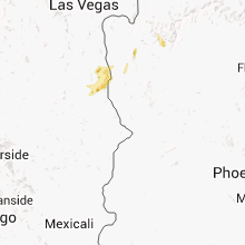
Nevada
| Local Time | Report Details |
|---|---|
| 1:00 PM PDT | Cal-nev-ari business reports several downed trees due to wind in cal-nev-ari. time estimated based on rada in clark county NV, 60.4 miles SSE of Las Vegas, NV |
Arizona
| Local Time | Report Details |
|---|---|
| 2:15 PM MST | Kifp reported a gust to 68 mp in mohave county AZ, 48.8 miles NNW of Lake Havasu City, AZ |
| 2:30 PM MST | Public reported that winds blew a tree onto a mobile home near the intersection of lakeside ave and glen st. photo sent in via faceboo in mohave county AZ, 46.3 miles NNW of Lake Havasu City, AZ |
| 6:27 PM MST | A newspaper reporter in bullhead city stated that several trees had been blown down in bullhead city along with some minor roof damage. it was also stated that 2 large in mohave county AZ, 48.3 miles NNW of Lake Havasu City, AZ |
Kentucky
| Local Time | Report Details |
|---|---|
| 4:40 PM CDT | Mesaured at paducah aso in mccracken county KY, 52.4 miles ESE of Cape Girardeau, MO |
Ohio
| Local Time | Report Details |
|---|---|
| 6:00 PM EDT | Cr 3 and cr e intersection closed due to downed power line in fulton county OH, 68 miles ENE of Fort Wayne, IN |
| 8:30 PM EDT | Trees down in west park area. numerous power outages...23500 customers in cuyahoga count in cuyahoga county OH, 7.6 miles WSW of Cleveland, OH |
| 1:25 AM EDT | Tree reported down on a house in greenhills. time estimated from rada in hamilton county OH, 11.3 miles N of Cincinnati, OH |
| 1:25 AM EDT | Tree reported down. time estimated from rada in hamilton county OH, 12.9 miles N of Cincinnati, OH |
| 1:46 AM EDT | Tree down on wires. near cliff road and brower road. time estimated from rada in hamilton county OH, 13.5 miles WNW of Cincinnati, OH |
Arkansas
| Local Time | Report Details |
|---|---|
| 5:30 PM CDT | Power lines and one large oak tree down. time estimated by rada in sebastian county AR, 23.9 miles SE of Fort Smith, AR |
Texas
| Local Time | Report Details |
|---|---|
| 5:55 PM CDT | Isolated roof and tree damage in and around the osr area to the northwest through north of the north zulch are in madison county TX, 79.7 miles WSW of Lufkin, TX |
Washington
| Local Time | Report Details |
|---|---|
| 5:55 PM PDT | Quarter sized hail reported near Davenport, WA, 34.9 miles W of Spokane, WA |
Iowa
| Local Time | Report Details |
|---|---|
| 3:23 AM CDT | Half Dollar sized hail reported near Sergeant Bluff, IA, 61.6 miles WSW of Storm Lake, IA, amost no rain while hail was falling...started raining after the hail ended. |
| 4:15 AM CDT | Golf Ball sized hail reported near De Soto, IA, 20.9 miles WSW of Des Moines, IA, golf ball sized hail via kcwi/great day viewer |
| 4:20 AM CDT | Half Dollar sized hail reported near De Soto, IA, 20.9 miles WSW of Des Moines, IA |
| 4:52 AM CDT | Quarter sized hail reported near Des Moines, IA, 4.7 miles SSW of Des Moines, IA, from airport weather observer |
Connect with Interactive Hail Maps