

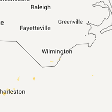
Hail Map for Monday, August 22, 2011

Number of Impacted Households on 8/22/2011
0
Impacted by 1" or Larger Hail
0
Impacted by 1.75" or Larger Hail
0
Impacted by 2.5" or Larger Hail
Square Miles of Populated Area Impacted on 8/22/2011
0
Impacted by 1" or Larger Hail
0
Impacted by 1.75" or Larger Hail
0
Impacted by 2.5" or Larger Hail
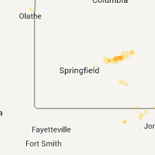


Cities Most Affected by Hail Storms of 8/22/2011
| Hail Size | Demographics of Zip Codes Affected | ||||||
|---|---|---|---|---|---|---|---|
| City | Count | Average | Largest | Pop Density | House Value | Income | Age |
| Charleston, SC | 1 | 1.75 | 1.75 | 2132 | $92k | $32.1k | 29.1 |
| Sheldon, IA | 1 | 1.75 | 1.75 | 55 | $79k | $35.9k | 39.7 |
| Winfred, SD | 1 | 1.75 | 1.75 | 2 | $61k | $39.6k | 33.2 |
Hail and Wind Damage Spotted on 8/22/2011
Filter by Report Type:Hail ReportsWind Reports
States Impacted
Missouri, Georgia, South Carolina, Louisiana, Florida, North Carolina, Alabama, North Dakota, South Dakota, Montana, Minnesota, IowaMissouri
| Local Time | Report Details |
|---|---|
| 12:45 PM UTC | Storm damage reported in clinton county MO, 32.2 miles NNE of Kansas City, MO |
Georgia
| Local Time | Report Details |
|---|---|
| 6:37 PM UTC | One tree down along rocky ford road. time estimated by rada in screven county GA, 54.2 miles SSE of Augusta, GA |
| 6:55 PM UTC | Central dispatch passed along a report of 6 to 7 trees down on northside drive near quincey batten loo in coffee county GA, 0.3 miles N of Douglas, GA |
| 7:25 PM UTC | Trees down in pearson reported by convenience store clerk with power outages as well. hail reported but size unknown. time estimated by rada in atkinson county GA, 14.2 miles S of Douglas, GA |
| 7:46 PM UTC | Winds estimated up to 60 mph with trees down near highway 203 and empire road. dime size hail also reporte in wayne county GA, 47.9 miles E of Douglas, GA |
| 8:03 PM UTC | Power line down and a metal roof blown onto highway 80 east just outside of brookle in bulloch county GA, 39.2 miles WNW of Savannah, GA |
| 8:19 PM UTC | A power pole reported down in waynesvill in brantley county GA, 62.4 miles N of Jacksonville, FL |
| 8:20 PM UTC | Wayne county emergency manager reported 5 trees down and a glass door blown out at ga hwy 203 and odum screven r in wayne county GA, 49.1 miles E of Douglas, GA |
| 9:15 PM UTC | Emergency management reported trees and power lines down in tarbor in camden county GA, 47.6 miles N of Jacksonville, FL |
| 9:25 PM UTC | Numerous trees down near the intersection of metcalf road and horn cemetary roa in thomas county GA, 26.4 miles NE of Tallahassee, FL |
| 9:48 PM UTC | Power poles leaning over and a pick up truck almost blown off highway 8 in chatham county GA, 11.2 miles ESE of Savannah, GA |
| 10:06 PM UTC | Power poles leaning over and a pick up truck almost blown off highway 8 in chatham county GA, 11.2 miles ESE of Savannah, GA |
| 10:48 PM UTC | Large limb blocking portions of highway 5 in long county GA, 47.9 miles WSW of Savannah, GA |
| 11:37 PM UTC | The bulloch county warning point reported 6 trees down in the portal georgia are in bulloch county GA, 56.5 miles NW of Savannah, GA |
South Carolina
| Local Time | Report Details |
|---|---|
| 6:55 PM UTC | Tree down on millpond roa in hampton county SC, 53 miles N of Savannah, GA |
| 7:50 PM UTC | One tree down along station 9 1 2 street. also reported dime size hai in charleston county SC, 31.1 miles SSE of Charleston, SC |
| 8:05 PM UTC | One tree down on powerline along the intersection of combahee road and hendersonville highwa in colleton county SC, 50.2 miles NNE of Savannah, GA |
| 9:09 PM UTC | Highway patrol reported a tree in the roadway at snake swamp road and highway 30 in orangeburg county SC, 56.5 miles E of Augusta, GA |
| 9:30 PM UTC | Public reported several large limbs down along old buckhead roa in bamberg county SC, 49.1 miles W of Charleston, SC |
| 9:42 PM UTC | Trees down at intersection of berea rd and buckhead rd. time estimated based on rada in colleton county SC, 48.1 miles W of Charleston, SC |
| 11:55 PM UTC | 1 small tree snapped and one large limb dow in berkeley county SC, 12.8 miles SSW of Charleston, SC |
| 7:55 PM EDT | Golf Ball sized hail reported near Charleston, SC, 15.3 miles SSW of Charleston, SC, golf ball hail on tricom st and highway 78. |
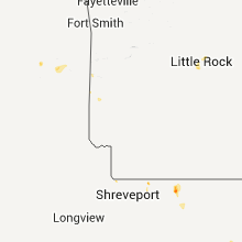
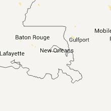
Louisiana
| Local Time | Report Details |
|---|---|
| 8:15 PM UTC | Tree down on hwy 84 southwest of winnfiel in winn county LA, 75.1 miles SE of Shreveport, LA |
| 8:15 PM UTC | Tree down on hwy 84 southwest of winnfiel in winn county LA, 68.5 miles SE of Shreveport, LA |
| 9:30 PM UTC | Trees down on farmerville hwy in rusto in lincoln county LA, 45.6 miles WSW of Bastrop, LA |
| 9:35 PM UTC | Trees down on hwy 15 in lincoln county LA, 46.9 miles W of Bastrop, LA |
| 10:00 PM UTC | Trees down on hwy 2 in bernic in union county LA, 43.5 miles W of Bastrop, LA |
Florida
| Local Time | Report Details |
|---|---|
| 9:15 PM UTC | Trees down at the intersection of pleasant ridge and bob sikes road. time estimated by rada in walton county FL, 26 miles NNE of Miramar Beach, FL |
| 9:15 PM UTC | Trees down at the intersection of sherwood road and us hwy 331. time estimated by rada in walton county FL, 25.4 miles NE of Miramar Beach, FL |
| 10:20 PM UTC | 1 tree down near the intersection of hwy 14 south and county road 25 in madison county FL, 51.4 miles E of Tallahassee, FL |
| 10:50 PM UTC | Tree reported down on pate road wes in duval county FL, 11.2 miles NNE of Jacksonville, FL |
| 10:52 PM UTC | Trees down on dunns creek road and caney lan in duval county FL, 9.1 miles NNE of Jacksonville, FL |
North Carolina
| Local Time | Report Details |
|---|---|
| 9:30 PM UTC | Tree blown down onto a mobile home on sycamore road in brunswick county NC, 13.8 miles SSW of Wilmington, NC |
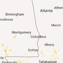
Alabama
| Local Time | Report Details |
|---|---|
| 10:01 PM UTC | Couple large trees down...powerlines down...damage to underpinning of a couple mobile homes...and trampoline blown into side of mobile home in and near the amazing grac in dallas county AL, 32.8 miles NNE of Camden, AL |
| 10:16 PM UTC | Greenville kprn-asos measured a 59 mph wind gus in butler county AL, 41.8 miles ESE of Camden, AL |
| 10:39 PM UTC | Butler county 911 reported several trees and powerlines dow in butler county AL, 40.4 miles ESE of Camden, AL |
| 12:30 AM UTC | Trees down near alm in clarke county AL, 45.6 miles SW of Camden, AL |
| 12:30 AM UTC | Trees and power lines down along county road 44 near tallahatta springs.also several power poles down on county road 4 in clarke county AL, 30.5 miles W of Camden, AL |
North Dakota
| Local Time | Report Details |
|---|---|
| 8:20 PM CDT | Ping Pong Ball sized hail reported near Wing, ND, 40.8 miles NE of Bismarck, ND, hail lasted about 5 minutes. not much wind. |
| 8:23 PM CDT | Quarter sized hail reported near Bismarck, ND, 5.4 miles SE of Bismarck, ND, dime to quarter sized hail...lasted for approx. 5 minutes... |
| 9:20 PM CDT | Quarter sized hail reported near Tuttle, ND, 45 miles ENE of Bismarck, ND, largest sized hail was quarters...heavy rain... lasted approx 5 mins... |
| 2:42 AM UTC | Heavy rain and winds up 60 mph estimated. in stutsman county ND, 68.6 miles E of Bismarck, ND |
| 10:34 PM CDT | Quarter sized hail reported near Medina, ND, 70.3 miles E of Bismarck, ND, hail was slightly larger than quarters...was still occuring at the time of the call... |
| 4:28 AM UTC | Also 1 inch diameter hail that lasted 5 minutes. time estimated by radar. delayed repor in lamoure county ND, 63.9 miles N of Aberdeen, SD |
| 4:55 AM UTC | Measured peak wind of 54 knots at the cooperstown airpor in griggs county ND, 59.2 miles SE of Devils Lake, ND |
South Dakota
| Local Time | Report Details |
|---|---|
| 9:49 PM CDT | Quarter sized hail reported near Howard, SD, 53.3 miles NW of Sioux Falls, SD |
| 10:52 PM CDT | Quarter sized hail reported near Winfred, SD, 43 miles NW of Sioux Falls, SD |
| 10:55 PM CDT | Golf Ball sized hail reported near Winfred, SD, 42.6 miles NW of Sioux Falls, SD |
| 11:24 PM CDT | Quarter sized hail reported near Madison, SD, 31.5 miles NW of Sioux Falls, SD, also 40 mph wind gusts. |
| 11:59 PM CDT | Quarter sized hail reported near Dell Rapids, SD, 19 miles N of Sioux Falls, SD |
Montana
| Local Time | Report Details |
|---|---|
| 4:20 AM UTC | 6-8 inch branch b in yellowstone county MT, 15 miles WSW of Billings, MT |
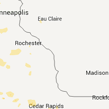
Minnesota
| Local Time | Report Details |
|---|---|
| 12:09 AM CDT | Quarter sized hail reported near Luverne, MN, 27.1 miles ENE of Sioux Falls, SD |
| 5:10 AM UTC | Storm damage reported in rock county MN, 27.1 miles ENE of Sioux Falls, SD |
| 7:41 AM UTC | Storm damage reported in douglas county MN, 70.6 miles N of Montevideo, MN |
| 8:24 AM UTC | Power outage reported by prior lake police. unknown caus in scott county MN, 19 miles SSW of Minneapolis, MN |
| 3:30 AM CDT | Quarter sized hail reported near Hayfield, MN, 54.9 miles NNE of Mason City, IA |
| 9:00 AM UTC | A couple of trees blown down in winona county MN, 41.8 miles WNW of La Crosse, WI |
| 9:05 AM UTC | A couple of trees blown down in winona county MN, 41.8 miles WNW of La Crosse, WI |
| 9:25 AM UTC | Stoplight knocked over hen cr 5 and hen cr 6 in hennepin county MN, 12.5 miles WSW of Minneapolis, MN |
| 9:45 AM UTC | Large tree limbs dow in mcleod county MN, 54.6 miles W of Minneapolis, MN |
| 9:59 AM UTC | Buffalo airport awos 0959 in wright county MN, 32.7 miles WNW of Minneapolis, MN |
| 10:15 AM UTC | Trees down on power lines.power ou in wright county MN, 31.4 miles NW of Minneapolis, MN |
| 10:45 AM UTC | 2 inch branch down and damaged gutte in hennepin county MN, 10.6 miles SSW of Minneapolis, MN |
Iowa
| Local Time | Report Details |
|---|---|
| 12:10 AM CDT | Quarter sized hail reported near Rock Rapids, IA, 29.3 miles ESE of Sioux Falls, SD |
| 12:10 AM CDT | Ping Pong Ball sized hail reported near Hull, IA, 39.3 miles SE of Sioux Falls, SD |
| 5:10 AM UTC | Tree damage with numerous branches down. a few branches down on home in lyon county IA, 29.3 miles ESE of Sioux Falls, SD |
| 12:30 AM CDT | Ping Pong Ball sized hail reported near Boyden, IA, 44.3 miles ESE of Sioux Falls, SD |
| 12:35 AM CDT | Golf Ball sized hail reported near Sheldon, IA, 49 miles NW of Storm Lake, IA |
| 12:58 AM CDT | Quarter sized hail reported near Ashton, IA, 50.1 miles ESE of Sioux Falls, SD, also estimated 60 mph winds with 3 inch branches down. |
| 6:06 AM UTC | Trees and power lines down in tow in o'brien county IA, 43.5 miles NNW of Storm Lake, IA |
| 6:30 AM UTC | Two grain bins destroye in o'brien county IA, 30.9 miles NNW of Storm Lake, IA |
| 7:14 AM UTC | Patio furniture blown around and branches down in yard. time estimated from rada in palo alto county IA, 41.5 miles NE of Storm Lake, IA |
| 7:14 AM UTC | Numerous trees uprooted in town. minor flooding also note in palo alto county IA, 41.5 miles NE of Storm Lake, IA |
| 7:35 AM UTC | Storm damage reported in kossuth county IA, 50.5 miles NE of Storm Lake, IA |
| 7:37 AM UTC | Power lines down in town. time estimated from rada in kossuth county IA, 52.3 miles W of Mason City, IA |
| 7:40 AM UTC | Storm damage reported in kossuth county IA, 54.3 miles W of Mason City, IA |
| 7:40 AM UTC | Considerable tree damage in town. many roads impassable. time estimated from rada in kossuth county IA, 52.3 miles W of Mason City, IA |
| 3:20 AM CDT | Quarter sized hail reported near Fort Dodge, IA, 51.8 miles E of Storm Lake, IA |
| 8:36 AM UTC | Extensive tree damage throughout the town of webster city. multiple tree limbs down about a foot in diameter. time estimated by rada in hamilton county IA, 56.9 miles SSW of Mason City, IA |
| 9:30 AM UTC | A couple of powerlines blown down in fayette county IA, 64.9 miles ESE of Mason City, IA |
| 9:35 AM UTC | Large tree blown down in fayette county IA, 65.2 miles SSW of La Crosse, WI |
| 5:52 AM CDT | Quarter sized hail reported near Webster City, IA, 58.5 miles NNW of Des Moines, IA |
| 5:57 AM CDT | Quarter sized hail reported near Webster City, IA, 57.3 miles SSW of Mason City, IA |
| 11:52 AM UTC | Tree down partially blocking road near the intersection of willow and main stree in worth county IA, 19.7 miles NW of Mason City, IA |
| 11:58 AM UTC | A few 4 to 6 diameter limbs down. extensive corn and bean crop damag in worth county IA, 18.9 miles N of Mason City, IA |
Connect with Interactive Hail Maps