

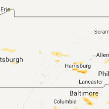
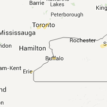
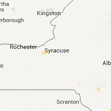
Hail Map for Sunday, August 21, 2011

Number of Impacted Households on 8/21/2011
0
Impacted by 1" or Larger Hail
0
Impacted by 1.75" or Larger Hail
0
Impacted by 2.5" or Larger Hail
Square Miles of Populated Area Impacted on 8/21/2011
0
Impacted by 1" or Larger Hail
0
Impacted by 1.75" or Larger Hail
0
Impacted by 2.5" or Larger Hail


Cities Most Affected by Hail Storms of 8/21/2011
| Hail Size | Demographics of Zip Codes Affected | ||||||
|---|---|---|---|---|---|---|---|
| City | Count | Average | Largest | Pop Density | House Value | Income | Age |
| Greenbush, MI | 2 | 1.88 | 2.00 | 145 | $107k | $32.3k | 60.0 |
| Fremont, NE | 2 | 1.75 | 1.75 | 246 | $90k | $38.3k | 39.5 |
| Glenwood, IA | 2 | 1.75 | 1.75 | 87 | $106k | $45.5k | 39.8 |
| Bellevue, NE | 1 | 3.00 | 3.00 | 1325 | $98k | $44.5k | 35.9 |
| Wallingford, VT | 1 | 1.75 | 1.75 | 21 | $94k | $40.5k | 47.1 |
| Omaha, NE | 1 | 1.75 | 1.75 | 5214 | $130k | $36.8k | 30.7 |
| Barton City, MI | 1 | 1.75 | 1.75 | 5 | $57k | $26.5k | 58.7 |
| Upperville, VA | 1 | 1.75 | 1.75 | 12 | $123k | $43.1k | 48.1 |
| Rock Port, MO | 1 | 1.75 | 1.75 | 16 | $59k | $30.9k | 46.2 |
| Lincoln, MI | 1 | 1.75 | 1.75 | 23 | $78k | $29.6k | 53.1 |
Hail and Wind Damage Spotted on 8/21/2011
Filter by Report Type:Hail ReportsWind Reports
States Impacted
Maryland, Nebraska, Delaware, Virginia, New York, New Jersey, Michigan, Ohio, Connecticut, Vermont, Pennsylvania, New Hampshire, Maine, North Carolina, District of Columbia, Mississippi, Georgia, Alabama, Louisiana, Indiana, Oklahoma, Arkansas, Kentucky, West Virginia, New Mexico, Montana, Massachusetts, South Carolina, Arizona, Minnesota, Iowa, MissouriMaryland
| Local Time | Report Details |
|---|---|
| 12:42 PM UTC | Several trees down in kent county MD, 29.4 miles E of Baltimore, MD |
| 1:14 PM EDT | Quarter sized hail reported near Dundalk, MD, 5.2 miles ESE of Baltimore, MD, quarter-size hail was observed on admiral blvd |
| 1:26 PM EDT | Quarter sized hail reported near Dundalk, MD, 5 miles ESE of Baltimore, MD |
| 5:30 PM UTC | Storm damage reported in baltimore county MD, 6 miles ESE of Baltimore, MD |
| 1:30 PM EDT | Half Dollar sized hail reported near Dundalk, MD, 6 miles ESE of Baltimore, MD |
| 5:32 PM UTC | Large tree branches blocking ranch ln near trappe rd in baltimore county MD, 6 miles ESE of Baltimore, MD |
| 1:40 PM EDT | Quarter sized hail reported near Dundalk, MD, 6 miles ESE of Baltimore, MD |
| 2:00 PM EDT | Quarter sized hail reported near Dundalk, MD, 8.3 miles ESE of Baltimore, MD |
| 6:20 PM UTC | Tree uprooted by thunderstorm wind gus in baltimore county MD, 10.7 miles ESE of Baltimore, MD |
| 2:41 PM EDT | Quarter sized hail reported near , , 47.6 miles S of Baltimore, MD |
| 2:41 PM EDT | Quarter sized hail reported near Pasadena, MD, 12.8 miles SE of Baltimore, MD |
| 7:32 PM UTC | Tree branches on house on kidmore ln in prince georges county MD, 27 miles SSW of Baltimore, MD |
| 8:45 PM UTC | Storm damage reported in calvert county MD, 46.9 miles S of Baltimore, MD |
| 8:55 PM UTC | Storm damage reported in calvert county MD, 46.9 miles S of Baltimore, MD |
| 9:07 PM UTC | Storm damage reported in calvert county MD, 47.2 miles S of Baltimore, MD |
| 9:07 PM UTC | Small limbs 1-2 inches in diameter blown down by thunderstorm gust in calvert county MD, 47.3 miles S of Baltimore, MD |
| 5:07 PM EDT | Quarter sized hail reported near Huntingtown, MD, 47.2 miles S of Baltimore, MD, hail was penny to quarter size |
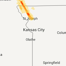
Nebraska
| Local Time | Report Details |
|---|---|
| 2:29 PM UTC | Estimated 50 to 60 mph winds in arcadia in valley county NE, 53.5 miles NW of Grand Island, NE |
| 10:10 PM MDT | Quarter sized hail reported near Arthur, NE, 54.1 miles NW of North Platte, NE, delayed report |
| 11:10 PM CDT | Quarter sized hail reported near Valentine, NE, 3.2 miles N of Valentine, NE |
| 10:20 PM MDT | Quarter sized hail reported near Arthur, NE, 50.3 miles NW of North Platte, NE |
| 4:20 AM UTC | Public reported large elm tree blown down 8 e of arthur last nigh in arthur county NE, 50.3 miles NW of North Platte, NE |
| 1:10 AM CDT | Half Dollar sized hail reported near Bloomfield, NE, 45.6 miles ENE of Oneill, NE |
| 1:45 AM CDT | Quarter sized hail reported near West Point, NE, 59.5 miles NW of Omaha, NE |
| 2:45 AM CDT | Quarter sized hail reported near Omaha, NE, 3.6 miles W of Omaha, NE, 32nd and charles |
| 7:45 AM UTC | One half inch hail...possibly up to one inch...and 1.65 inches of rain. late repor in cuming county NE, 58.5 miles NW of Omaha, NE |
| 3:45 AM CDT | Golf Ball sized hail reported near Omaha, NE, 3.6 miles W of Omaha, NE, near 50th and center |
| 3:45 AM CDT | Tea Cup sized hail reported near Bellevue, NE, 7 miles S of Omaha, NE, numerous reports of 2 to 3 inch hail with some windshields broken out |
| 4:00 AM CDT | Golf Ball sized hail reported near Fremont, NE, 31.1 miles WNW of Omaha, NE |
| 4:03 AM CDT | Golf Ball sized hail reported near Fremont, NE, 31.1 miles WNW of Omaha, NE |
Delaware
| Local Time | Report Details |
|---|---|
| 2:40 PM UTC | Trained spotter estimated winds to 60 mph near the dover speedwa in kent county DE, 59.2 miles E of Baltimore, MD |
| 2:40 PM UTC | Tree limbs dow in kent county DE, 59.2 miles E of Baltimore, MD |
| 2:40 PM UTC | Trees and tree limbs dow in kent county DE, 59.2 miles E of Baltimore, MD |
| 2:50 PM UTC | A 77 mph thunderstorm wind gust was measured at the dover af in kent county DE, 58.7 miles NNW of Ocean City, MD |
| 2:50 PM UTC | Wind damage reported at the dover afb but details are unknown at this tim in kent county DE, 58.7 miles NNW of Ocean City, MD |
| 11:30 PM UTC | Wires down in sussex county DE, 29.6 miles NW of Ocean City, MD |
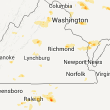
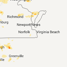
Virginia
| Local Time | Report Details |
|---|---|
| 12:06 PM EDT | Quarter sized hail reported near Mc Dowell, VA, 47.8 miles SSE of Elkins, WV, leaves were shredded by hail |
| 5:15 PM UTC | 3 to 4 in limbs down in city of roanoke county VA, 2.2 miles NNW of Roanoke, VA |
| 5:20 PM UTC | Large tree broken in loudoun county VA, 67 miles WSW of Baltimore, MD |
| 1:21 PM EDT | Quarter sized hail reported near Upperville, VA, 69.8 miles WSW of Baltimore, MD |
| 1:21 PM EDT | Golf Ball sized hail reported near Upperville, VA, 69.8 miles WSW of Baltimore, MD |
| 5:28 PM UTC | 4 large trees blown down from thunderstorm win in loudoun county VA, 69.3 miles WSW of Baltimore, MD |
| 5:28 PM UTC | Large limbs blown off in tremendous thunderstorm wind. time estimated from radar in loudoun county VA, 69.8 miles WSW of Baltimore, MD |
| 5:40 PM UTC | Some small branches were broken from trees by thunderstorm wind in fauquier county VA, 80.6 miles WSW of Baltimore, MD |
| 1:40 PM EDT | Quarter sized hail reported near Marshall, VA, 80.6 miles WSW of Baltimore, MD, some small branches were broken from trees by thunderstorm wind |
| 5:45 PM UTC | Large branch down in city of bedford county VA, 23 miles E of Roanoke, VA |
| 6:00 PM UTC | Several trees down in bedford county VA, 10 miles ESE of Roanoke, VA |
| 6:12 PM UTC | Trees down on mussel swamp rd in essex county VA, 48.9 miles ENE of Richmond, VA |
| 6:15 PM UTC | Several trees down in fauquier count in fauquier county VA, 75.2 miles WSW of Baltimore, MD |
| 6:18 PM UTC | Tree down in henry county VA, 39.4 miles SSE of Roanoke, VA |
| 6:20 PM UTC | Tree down in campbell county VA, 45.6 miles E of Roanoke, VA |
| 6:29 PM UTC | Tree down in pittsylvania county VA, 45.4 miles SSE of Roanoke, VA |
| 6:35 PM UTC | Thunderstorm winds blew a large roof off a hay barn at locust level farm. damage was estimated to be ove in halifax county VA, 54.6 miles ESE of Roanoke, VA |
| 6:45 PM UTC | Many trees down along hwy 60 - from 4 mi w of co border to mt rush hwy in buckingham county VA, 60.9 miles W of Richmond, VA |
| 6:52 PM UTC | Large trees down near intersection of rolling rd and blue slate ln in albemarle county VA, 53.9 miles NW of Richmond, VA |
| 6:53 PM UTC | Trees and wires down on buck island rd in albemarle county VA, 52.1 miles NW of Richmond, VA |
| 6:54 PM UTC | A few large branches torn off in thunderstorm wind in albemarle county VA, 51.7 miles NW of Richmond, VA |
| 7:00 PM UTC | Numerous trees down blocking roads in the lake monticello are in fluvanna county VA, 47.4 miles NW of Richmond, VA |
| 7:00 PM UTC | Several trees down in buckingham county VA, 50 miles W of Richmond, VA |
| 7:05 PM UTC | Tree down in halifax county VA, 66.5 miles NNW of Raleigh, NC |
| 7:06 PM UTC | Tree down in pittsylvania county VA, 52.8 miles SSE of Roanoke, VA |
| 7:10 PM UTC | Tree down in halifax county VA, 64.5 miles NNW of Raleigh, NC |
| 7:13 PM UTC | Tree down in halifax county VA, 66 miles N of Raleigh, NC |
| 7:20 PM UTC | Tree down in halifax county VA, 60.9 miles SE of Roanoke, VA |
| 7:25 PM UTC | Tree down in halifax county VA, 64 miles SE of Roanoke, VA |
| 7:32 PM UTC | Tree down on route 60 near the courthous in cumberland county VA, 32.3 miles W of Richmond, VA |
| 7:50 PM UTC | Numerous trees down across southeast prince edward county in the meherrin are in prince edward county VA, 48.5 miles SW of Richmond, VA |
| 7:55 PM UTC | Trees down in the green bay are in prince edward county VA, 44.5 miles SW of Richmond, VA |
| 6:00 PM EDT | Quarter sized hail reported near Saxis, VA, 44.5 miles SW of Ocean City, MD |
New York
| Local Time | Report Details |
|---|---|
| 4:25 PM UTC | Limbs down in village of hamburg in erie county NY, 11.7 miles SSE of Buffalo, NY |
| 4:25 PM UTC | Several large tents with metal frames blown over at erie county fair in erie county NY, 11.7 miles SSE of Buffalo, NY |
| 4:30 PM UTC | Southbound lanes of the saw mill river parkway blocked due to fallen trees. time estimated by rada in westchester county NY, 34.4 miles NNE of Brooklyn, NY |
| 4:35 PM UTC | Trees and wires down on rte 2 and 2 trees down burning on wires on pine r in columbia county NY, 47.3 miles SSE of Schenectady, NY |
| 4:40 PM UTC | Multiple trees down... caller indicated very strong winds with the t in erie county NY, 16.3 miles SE of Buffalo, NY |
| 4:45 PM UTC | Trees and wires dow in ulster county NY, 67.8 miles S of Schenectady, NY |
| 4:45 PM UTC | Trees and power lines down 283 beaver dam road in albany county NY, 20.8 miles SSE of Schenectady, NY |
| 4:54 PM UTC | Tree down on wires. power outage in albany county NY, 11.6 miles ESE of Schenectady, NY |
| 5:05 PM UTC | Trees and wires down. power outage in albany county NY, 13 miles ESE of Schenectady, NY |
| 5:06 PM UTC | Tree down on frisbee street blocking roa in columbia county NY, 37.4 miles SE of Schenectady, NY |
| 5:10 PM UTC | Various trees down around town. time estimated by rada in putnam county NY, 52.5 miles NNE of Brooklyn, NY |
| 5:15 PM UTC | Tree dow in saratoga county NY, 13.4 miles E of Schenectady, NY |
| 5:40 PM UTC | Trees down in dutchess county NY, 75.6 miles SSE of Schenectady, NY |
| 5:40 PM UTC | Multiple trees down on metro north tracks in the vicinity of pleasantville. train service is suspende in westchester county NY, 32.8 miles NNE of Brooklyn, NY |
| 5:40 PM UTC | 2 trees down in washington county NY, 34.8 miles ENE of Schenectady, NY |
| 5:48 PM UTC | Multiple trees down on metro north tracks in the vicinity of pleasantville. train service is suspended. time estimated by rada in westchester county NY, 32.8 miles NNE of Brooklyn, NY |
| 6:00 PM UTC | One tree down in mahopac. large branches and limbs down and sheryl lane and russ roa in putnam county NY, 48.5 miles NNE of Brooklyn, NY |
| 7:15 PM UTC | Multiple homes with roofs ripped of in wayne county NY, 31 miles W of Syracuse, NY |
| 7:30 PM UTC | Multiple trees and wires dow in cayuga county NY, 23.2 miles WNW of Syracuse, NY |
| 7:30 PM UTC | Barn severly damaged... possible tornad in cayuga county NY, 20.9 miles WNW of Syracuse, NY |
| 7:30 PM UTC | Multiple trees and wires dow in cayuga county NY, 20.9 miles WNW of Syracuse, NY |
| 7:30 PM UTC | Barn... ripped off the foundation and severely damaged... possible tornad in wayne county NY, 31 miles W of Syracuse, NY |
| 7:30 PM UTC | Multiple homes with roofs ripped of in wayne county NY, 31 miles W of Syracuse, NY |
| 7:30 PM UTC | Multiple trees and wires dow in wayne county NY, 31 miles W of Syracuse, NY |
| 3:30 PM EDT | Half Dollar sized hail reported near Meridian, NY, 21.3 miles WNW of Syracuse, NY, multiple reports of hail in the town of meridian. |
| 7:40 PM UTC | Multiple trees and wires dow in cayuga county NY, 23.2 miles WNW of Syracuse, NY |
| 7:45 PM UTC | Multiple trees down and wires... bush hill r in cayuga county NY, 24.4 miles W of Syracuse, NY |
| 7:50 PM UTC | Multiple tree branches down...some large. also tree branches down in lysande in onondaga county NY, 17.4 miles WNW of Syracuse, NY |
| 7:50 PM UTC | Pole and branches down on plainville road between sprague and gates roads in onondaga county NY, 16.8 miles WNW of Syracuse, NY |
| 3:55 PM EDT | Quarter sized hail reported near Syracuse, NY, 3.5 miles N of Syracuse, NY, old report from sunday. received from newschannel 9 facebook page. report time verified by radar. |
| 3:58 PM EDT | Quarter sized hail reported near Weedsport, NY, 20.9 miles W of Syracuse, NY |
| 8:20 PM UTC | Multiple trees down across yorktown heights. hunter brook and baptist church road closed due to several trees dow in westchester county NY, 41.3 miles NNE of Brooklyn, NY |
| 8:35 PM UTC | Trees down across tracks at rosedale lirr station. delays reporte in queens county NY, 13.3 miles E of Brooklyn, NY |
| 8:39 PM UTC | Trees down across railroad lines at laurelton station. delays reporte in queens county NY, 12.7 miles E of Brooklyn, NY |
| 8:45 PM UTC | Trees down in somers reported by state police in westchester county NY, 46.7 miles NNE of Brooklyn, NY |
| 8:52 PM UTC | Tree down on a house at 1st street and marcellus road. fire dept respondin in nassau county NY, 18.8 miles ENE of Brooklyn, NY |
| 9:05 PM UTC | State police reporting trees down in north sale in westchester county NY, 49.2 miles NNE of Brooklyn, NY |
| 9:15 PM UTC | Trees and wires down and awning ripped off building at 1424 state route 9 queen in warren county NY, 40.4 miles NNE of Schenectady, NY |
| 9:15 PM UTC | Trees down and awning ripped off buildin in warren county NY, 40.4 miles NNE of Schenectady, NY |
| 9:50 PM UTC | Trees down in fort an in washington county NY, 47.7 miles NNE of Schenectady, NY |
| 10:00 PM UTC | Numerous trees down. trees on house in washington county NY, 53.7 miles NE of Schenectady, NY |
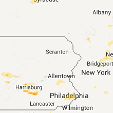
| 6:45 PM EDT | Quarter sized hail reported near Walton, NY, 59.2 miles NNE of Scranton, PA |
New Jersey
| Local Time | Report Details |
|---|---|
| 4:45 PM UTC | Large tree branches broken in morris county NJ, 24.2 miles WNW of Brooklyn, NY |
| 5:18 PM UTC | Large 5-6 inch diameter tree limb down at godwin avenue and joshua lan in bergen county NJ, 23.2 miles NNW of Brooklyn, NY |
| 5:19 PM UTC | Large 4-5 inch diameter tree limb down blocking bell and burke street in bergen county NJ, 22 miles NNW of Brooklyn, NY |
| 7:15 PM UTC | Poles and wires down in mansfield in burlington county NJ, 56.3 miles SW of Brooklyn, NY |
| 7:35 PM UTC | Trees down in cream ridge in monmouth county NJ, 47.8 miles SW of Brooklyn, NY |
| 7:35 PM UTC | Tree limbs down on wires in upper freehold in monmouth county NJ, 47 miles SW of Brooklyn, NY |
| 7:48 PM UTC | Several trees... telephone poles... and wires down along burlington path road in monmouth county NJ, 47.8 miles SW of Brooklyn, NY |
| 10:52 PM UTC | Large tree down on sloatsburg road near ringwood manor. roadway close in passaic county NJ, 32.3 miles NNW of Brooklyn, NY |
Michigan
| Local Time | Report Details |
|---|---|
| 1:21 PM EDT | Golf Ball sized hail reported near Barton City, MI, 27.4 miles SSW of Alpena, MI |
| 1:30 PM EDT | Quarter sized hail reported near Mikado, MI, 36.2 miles S of Alpena, MI, mostly pea size but max is 1 inch. |
| 1:30 PM EDT | Golf Ball sized hail reported near Lincoln, MI, 27.7 miles S of Alpena, MI |
| 1:40 PM EDT | Golf Ball sized hail reported near Greenbush, MI, 34.3 miles S of Alpena, MI, time estimated from radar |
| 1:45 PM EDT | Hen Egg sized hail reported near Greenbush, MI, 36.5 miles S of Alpena, MI, spotter traveled to alcona iosco county line and found max hail of 1 to 2 inches on us route 23. |
Ohio
| Local Time | Report Details |
|---|---|
| 5:26 PM UTC | Via social media. large tree limbs down. car crushe in montgomery county OH, 47 miles NNE of Cincinnati, OH |
| 8:45 PM UTC | Tree blown over and blocking state route 160 just outside of vinton heading towards ewingto in gallia county OH, 57.7 miles NW of Charleston, WV |
| 8:45 PM UTC | Tree down on state route 325 just outside of vinton in gallia county OH, 57.7 miles NW of Charleston, WV |
| 8:55 PM UTC | Damage to multiple trees...one tree split...large branches broken on others. estimated wind gust around 60mp in gallia county OH, 53.8 miles NW of Charleston, WV |
| 9:05 PM UTC | 70 foot tall tree blown down into powerlines and blocking bulaville pike...power is out in that area in gallia county OH, 47.7 miles NW of Charleston, WV |
Connecticut
| Local Time | Report Details |
|---|---|
| 5:40 PM UTC | Multiple trees dow in litchfield county CT, 68.7 miles SSE of Schenectady, NY |
| 5:45 PM UTC | Trees dow in litchfield county CT, 75.7 miles NNE of Brooklyn, NY |
| 6:00 PM UTC | Wires dow in litchfield county CT, 68.3 miles SE of Schenectady, NY |
| 6:25 PM UTC | Near intersection of rte 183 and hillandale blvd trees down on fire on wires causing power outage in litchfield county CT, 79.5 miles SSE of Schenectady, NY |
| 6:26 PM UTC | One tree down on side of road on route 39. time estimated by rada in fairfield county CT, 66.4 miles NNE of Brooklyn, NY |
| 7:52 PM UTC | Large tree down on house on pliny street in hartford county CT, 65.6 miles W of Providence, RI |
| 4:22 PM EDT | Quarter sized hail reported near Redding, CT, 52.7 miles NE of Brooklyn, NY |
| 4:48 PM EDT | Half Dollar sized hail reported near Danbury, CT, 55.9 miles NNE of Brooklyn, NY, ct state police reports interstate 84 is closed in danbury due to large hail damaging cars. |
| 5:30 PM EDT | Half Dollar sized hail reported near Danbury, CT, 55.9 miles NNE of Brooklyn, NY, ct state police reports interstate 84 is closed in danbury due to large hail damaging cars. |
| 9:33 PM UTC | Wires down on benson drive in fairfield county CT, 55.9 miles NNE of Brooklyn, NY |
| 10:08 PM UTC | Trees and wires down on 172 near flag swamp road. time estimated by rada in new haven county CT, 68.2 miles NE of Brooklyn, NY |
Vermont
| Local Time | Report Details |
|---|---|
| 1:42 PM EDT | Quarter sized hail reported near Bethel, VT, 53.2 miles SSE of Burlington, VT, quarter size hail in bethel center |
| 5:42 PM UTC | Trees down causing power outages in randolph area in orange county VT, 46.4 miles SE of Burlington, VT |
| 1:54 PM EDT | Quarter sized hail reported near Greensboro, VT, 45.7 miles E of Burlington, VT, quarter size hail along rte 16 |
| 5:55 PM UTC | Two seperate trees down. one on rt 9e and the other austin hill road. time estimate in bennington county VT, 38.4 miles E of Schenectady, NY |
| 2:05 PM EDT | Quarter sized hail reported near Morgan, VT, 66.4 miles ENE of Burlington, VT |
| 6:10 PM UTC | Trees dow in windham county VT, 67.7 miles E of Schenectady, NY |
| 8:16 PM UTC | Trees and wires down in chester in windsor county VT, 75.1 miles ENE of Schenectady, NY |
| 6:00 PM EDT | Quarter sized hail reported near Underhill, VT, 16.1 miles ENE of Burlington, VT, quarter size hail |
| 10:05 PM UTC | Trees down in west pawlet in rutland county VT, 53.5 miles NE of Schenectady, NY |
| 10:06 PM UTC | Trees down in west pawlet in rutland county VT, 53.5 miles NE of Schenectady, NY |
| 10:10 PM UTC | Trees down... no power in addison county VT, 38.7 miles SSE of Burlington, VT |
| 6:12 PM EDT | Quarter sized hail reported near Cambridge, VT, 20.1 miles NE of Burlington, VT, quarter size hail at a bed and breakfast in fletcher |
| 10:15 PM UTC | Numerous trees down from west pawlet to danby with reports of damage per vt state police in rutland county VT, 60.4 miles NE of Schenectady, NY |
| 10:35 PM UTC | Trees down in orange county VT, 42.8 miles SE of Burlington, VT |
| 6:50 PM EDT | Golf Ball sized hail reported near Wallingford, VT, 63.4 miles NE of Schenectady, NY, golfball size hail reported per vt state police |
Pennsylvania
| Local Time | Report Details |
|---|---|
| 5:45 PM UTC | Wires down in lower gwynedd in montgomery county PA, 75.9 miles WSW of Brooklyn, NY |
| 5:45 PM UTC | Wires down in upper gwynedd in montgomery county PA, 74.4 miles WSW of Brooklyn, NY |
| 6:05 PM UTC | Trees and wires down from state college to linden hall and boalsburg. trees on some house in centre county PA, 0.3 miles S of State College, PA |
| 2:07 PM EDT | Half Dollar sized hail reported near Slippery Rock, PA, 36.1 miles N of Pittsburgh, PA |
| 2:20 PM EDT | Quarter sized hail reported near Slippery Rock, PA, 39.5 miles N of Pittsburgh, PA, event occurred between 217 pm 08 21 2011 and 232 pm 08 21 2011 |
| 2:22 PM EDT | Quarter sized hail reported near Butler, PA, 32.7 miles N of Pittsburgh, PA, event occurred between 207 pm 08/21/2011 and 222 pm 08/21/2011 |
| 2:22 PM EDT | Half Dollar sized hail reported near Butler, PA, 32.7 miles N of Pittsburgh, PA, event occurred between 207 pm 08/21/2011 and 222 pm 08/21/2011 |
| 2:26 PM EDT | Quarter sized hail reported near Butler, PA, 32.7 miles N of Pittsburgh, PA, event occurred between 211 pm 08/21/2011 and 226 pm 08/21/2011 |
| 2:32 PM EDT | Quarter sized hail reported near Slippery Rock, PA, 43.6 miles N of Pittsburgh, PA, event occurred between 217 pm 08 21 2011 and 232 pm 08 21 2011 |
| 2:35 PM EDT | Quarter sized hail reported near Chicora, PA, 37.8 miles NNE of Pittsburgh, PA |
| 6:45 PM UTC | Trees and wires down in northeast philadelphia in philadelphia county PA, 68.4 miles SW of Brooklyn, NY |
| 6:52 PM UTC | Trees and wires down in feasterville in bucks county PA, 65.9 miles SW of Brooklyn, NY |
| 2:55 PM EDT | Wires down in bensalem in bucks county PA, 64.2 miles SW of Brooklyn, NY |
| 3:30 PM EDT | Half Dollar sized hail reported near Newport, PA, 50.5 miles ESE of State College, PA, hail varying in size from dime to half dollar at bucks valley |
| 3:40 PM EDT | Quarter sized hail reported near Enola, PA, 59.6 miles SE of State College, PA |
| 7:56 PM UTC | Trees down. several small buildings on farm damage in dauphin county PA, 62.1 miles N of Baltimore, MD |
| 8:28 PM UTC | Trees down on main st... route 819... and steele road in westmoreland county PA, 25.2 miles E of Pittsburgh, PA |
| 4:30 PM EDT | Storm damage reported in lancaster county PA, 57.9 miles N of Baltimore, MD |
| 4:30 PM EDT | Quarter sized hail reported near Elizabethtown, PA, 57.9 miles N of Baltimore, MD |
| 9:10 PM UTC | Trees down in lehigh county PA, 57.4 miles S of Scranton, PA |
| 9:13 PM UTC | Numerous trees down... some on houses... extending from allentown to whitehall twp in lehigh county PA, 57.4 miles S of Scranton, PA |
| 9:13 PM UTC | Numerous trees down near whitehall high school....also trees and wires down between south whitehall twp and whitehall twp in lehigh county PA, 52.4 miles S of Scranton, PA |
New Hampshire
| Local Time | Report Details |
|---|---|
| 6:21 PM UTC | Large limbs down blocking washington and mechanic streets in downtown keene in cheshire county NH, 83.8 miles E of Schenectady, NY |
| 6:28 PM UTC | Trees and wires down on south village road in cheshire county NH, 76.5 miles E of Schenectady, NY |
| 6:29 PM UTC | Tree down across road on route 12a near fire station in cheshire county NH, 83.3 miles ENE of Schenectady, NY |
| 6:35 PM UTC | Multiple trees down in charlestown reported by local police in sullivan county NH, 82.5 miles ENE of Schenectady, NY |
| 6:35 PM UTC | Trees and wires down on kingsbury road. large limbs down on county roa in cheshire county NH, 78.8 miles ENE of Schenectady, NY |
| 6:37 PM UTC | Trees down on wires on route 12a. trees and wires down blocking high stree in cheshire county NH, 83 miles ENE of Schenectady, NY |
| 6:39 PM UTC | Tree and wires down in sullivan county NH, 82.9 miles ENE of Schenectady, NY |
| 6:43 PM UTC | Tree down on house...several more trees and wires down in town in sullivan county NH, 88.2 miles ENE of Schenectady, NY |
| 6:46 PM UTC | Numerous reports throughout downtown keene of multiple large tree limbs down obstructing sidewalks and roads. one tree struck by lightning and another tree down across in cheshire county NH, 83.8 miles E of Schenectady, NY |
| 6:50 PM UTC | Trees and wires down on grand view road and lempster road. couple other locations also with trees dow in sullivan county NH, 92.5 miles ENE of Schenectady, NY |
| 6:54 PM UTC | Multiple trees down suspected microburst no hail in sullivan county NH, 87.1 miles SSE of Burlington, VT |
| 7:28 PM UTC | Trees down on wires in alexandria in grafton county NH, 77 miles W of Portland, ME |
| 7:32 PM UTC | 2 trees down on wires in bristol and a tree down on a house in grafton county NH, 74.5 miles W of Portland, ME |
| 7:35 PM UTC | Trees and wires down on stimson lake road in grafton county NH, 78.5 miles W of Portland, ME |
| 7:40 PM UTC | Trees and wires down on rocky shore road in grafton county NH, 74.5 miles W of Portland, ME |
| 7:40 PM UTC | Trees blocking road between i93 and plymouth in grafton county NH, 72.1 miles W of Portland, ME |
| 7:40 PM UTC | Tree across buffalo rd and wires down in grafton county NH, 78.5 miles W of Portland, ME |
| 7:40 PM UTC | Tree fell across rt 25 and took down wires in grafton county NH, 78.5 miles W of Portland, ME |
| 8:00 PM UTC | Tree fell on wires and is on fire on 828 bean road in carroll county NH, 57.6 miles W of Portland, ME |
| 8:05 PM UTC | Trees on wires at groves near israel road in carroll county NH, 58.4 miles W of Portland, ME |
| 8:10 PM UTC | Trees and wires down in bridgewater in carroll county NH, 49.3 miles W of Portland, ME |
| 8:30 PM UTC | Trees and wires down in center conway in carroll county NH, 48.5 miles WNW of Portland, ME |
| 11:35 PM UTC | Trees down rt 12a near freeman r in sullivan county NH, 78 miles SSE of Burlington, VT |
| 12:20 AM UTC | Large limbs and trees down abbott rd and sugarhill r in grafton county NH, 83.8 miles SE of Burlington, VT |
| 12:30 AM UTC | Multiple trees down all along ball park rd to route 4. trees on houses and cars. could be possible tornado and nws survey will be done tomorro in grafton county NH, 82.7 miles SE of Burlington, VT |
Maine
| Local Time | Report Details |
|---|---|
| 7:00 PM UTC | Trees and branches down on rt201 between jackman and border crossing in somerset county ME, 98.8 miles NW of Bangor, ME |
| 8:50 PM UTC | Tree on house on oak st in york county ME, 33.4 miles WSW of Portland, ME |
| 5:11 PM EDT | Quarter sized hail reported near Washburn, ME, 3.1 miles SW of Caribou, ME |
| 9:12 PM UTC | Tree down on brown road in buxton in york county ME, 13.3 miles W of Portland, ME |
| 5:15 PM EDT | Quarter sized hail reported near Caribou, ME, 2.1 miles N of Caribou, ME |
| 9:23 PM UTC | Tree across mcguire road in androscoggin county ME, 28.5 miles NNW of Portland, ME |
| 9:30 PM UTC | Multiple large branches in excess 10 inches in diameter down near harlow hill in oxford county ME, 64.1 miles N of Portland, ME |
| 9:35 PM UTC | Large tree across corner of route 2 and mitchell in oxford county ME, 63.9 miles NNW of Portland, ME |
| 7:20 PM EDT | Quarter sized hail reported near Caribou, ME, 0.1 miles NE of Caribou, ME |
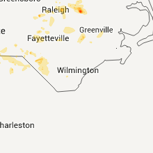
North Carolina
| Local Time | Report Details |
|---|---|
| 7:01 PM UTC | Large bushes blown down and blocking southbound lane of us 1 in richmond county NC, 63.2 miles ESE of Charlotte, NC |
| 3:06 PM EDT | Quarter sized hail reported near Rockingham, NC, 64.1 miles ESE of Charlotte, NC, 1 inch diameter hail |
| 7:40 PM UTC | Tree down on pilot mountai in surry county NC, 70.6 miles SSW of Roanoke, VA |
| 7:46 PM UTC | Tree limbs down on farm life ave in craven county NC, 87.1 miles NNE of Wilmington, NC |
| 7:57 PM UTC | Power line and several limbs down in forsyth county NC, 74.9 miles NNE of Charlotte, NC |
| 7:57 PM UTC | Power lines were blocking the northbound lane of doral drive. limb was up to 2 feet in diameter... possibly part of a tre in forsyth county NC, 74.9 miles NNE of Charlotte, NC |
| 8:07 PM UTC | Tree down in richmond county NC, 63.2 miles ESE of Charlotte, NC |
| 8:07 PM UTC | Tree down in richmond county NC, 57 miles E of Charlotte, NC |
| 8:15 PM UTC | Tree down near south main st in scotland county NC, 83.9 miles SSW of Raleigh, NC |
| 8:19 PM UTC | One pine tree was reported down north of laurinbur in scotland county NC, 80.1 miles ESE of Charlotte, NC |
| 8:30 PM UTC | 3 trees down - nc38...us220...nc331 - in and around rockingham in richmond county NC, 64.1 miles ESE of Charlotte, NC |
| 8:45 PM UTC | Trees down at alex benton rd. and goldsboro hw in sampson county NC, 40.3 miles SSE of Raleigh, NC |
| 8:50 PM UTC | Tree blown down on south pinkston street and alexander avenue. time estimate in vance county NC, 39.5 miles NNE of Raleigh, NC |
| 8:50 PM UTC | Tree blown down on chevis. time estimate in vance county NC, 31 miles NNE of Raleigh, NC |
| 8:54 PM UTC | Several trees were reported down near the intersection of west ridgeway street and brehon stree in warren county NC, 50.2 miles NNE of Raleigh, NC |
| 8:55 PM UTC | Several trees were reported down near baltimore road and parktown roa in warren county NC, 50 miles NNE of Raleigh, NC |
| 9:06 PM UTC | 1 foot diameter oak tree snapped in half. many large limbs from additional trees also blown dow in robeson county NC, 67.4 miles WNW of Wilmington, NC |
| 9:13 PM UTC | Couple of trees down along highway 4 in northampton county NC, 68.6 miles S of Richmond, VA |
| 9:14 PM UTC | Power lines down near exit 22 blocking portions of i-9 in robeson county NC, 67.7 miles WNW of Wilmington, NC |
| 9:23 PM UTC | Tree down on popes crossing road. time estimated based off rada in robeson county NC, 65 miles WNW of Wilmington, NC |
| 9:28 PM UTC | One tree blown down along mark edwards roa in wayne county NC, 51.3 miles ESE of Raleigh, NC |
| 9:30 PM UTC | Trees blown dow in halifax county NC, 70.3 miles NE of Raleigh, NC |
| 9:36 PM UTC | Tree blown dow in halifax county NC, 73.3 miles NE of Raleigh, NC |
| 9:50 PM UTC | Tree blown down. fire department respondin in franklin county NC, 32.2 miles NE of Raleigh, NC |
| 5:55 PM EDT | Quarter sized hail reported near Nebo, NC, 60.9 miles SSE of Bristol, TN, a period of dime to quarter sized hail fell at mountain harbour marina. also had very strong wind...perhaps enough to bring down limbs or a few trees...but could not se |
| 9:57 PM UTC | Several reports of trees blown down in the castalia area. possible structural damag in nash county NC, 37.3 miles ENE of Raleigh, NC |
| 10:08 PM UTC | Tree down on pine bush roa in lenoir county NC, 62.4 miles SE of Raleigh, NC |
| 10:14 PM UTC | Large tree down along rough and ready road. time estimated based off rada in columbus county NC, 57.6 miles W of Wilmington, NC |
| 10:37 PM UTC | Large pine limbs down across prison camp road. time estimated based off rada in columbus county NC, 45.5 miles W of Wilmington, NC |
| 10:41 PM UTC | Large tree down across hilburn road. time estimated based off rada in columbus county NC, 47.8 miles W of Wilmington, NC |
| 6:41 PM EDT | Half Dollar sized hail reported near Rocky Mount, NC, 44.6 miles E of Raleigh, NC |
| 6:44 PM EDT | Half Dollar sized hail reported near Rocky Mount, NC, 45.5 miles E of Raleigh, NC |
| 6:45 PM EDT | Quarter sized hail reported near Rocky Mount, NC, 43.3 miles ENE of Raleigh, NC |
| 10:45 PM UTC | Two pine trees blown dow in nash county NC, 43.3 miles ENE of Raleigh, NC |
| 6:50 PM EDT | Quarter sized hail reported near Rocky Mount, NC, 44.6 miles E of Raleigh, NC |
| 6:50 PM EDT | Half Dollar sized hail reported near Rocky Mount, NC, 44.2 miles ENE of Raleigh, NC |
| 6:55 PM EDT | Quarter sized hail reported near Rocky Mount, NC, 44.6 miles E of Raleigh, NC |
| 11:00 PM UTC | Power lines and poles blown down on halifax road and west mount drive in nash county NC, 44.5 miles ENE of Raleigh, NC |
| 11:03 PM UTC | Large limbs blown down in nash county NC, 44.6 miles E of Raleigh, NC |
| 7:05 PM EDT | Half Dollar sized hail reported near Rocky Mount, NC, 48.1 miles E of Raleigh, NC |
| 11:30 PM UTC | One tree blown down in chatham county NC, 32.6 miles W of Raleigh, NC |
| 11:30 PM UTC | Tree blown down along highway 87 in chatham county NC, 33 miles W of Raleigh, NC |
| 12:07 AM UTC | Tree down in yard in wake county NC, 13.4 miles NE of Raleigh, NC |
| 12:21 AM UTC | One tree blown down on mitchell mill road in wake county NC, 16.1 miles ENE of Raleigh, NC |
| 12:26 AM UTC | 10 -12 trees down in east rocky mt in edgecombe county NC, 49 miles ENE of Raleigh, NC |
| 8:28 PM EDT | Quarter sized hail reported near Sanford, NC, 36.9 miles SW of Raleigh, NC |
| 12:40 AM UTC | Large limbs blown down in richmond county NC, 62.1 miles E of Charlotte, NC |
| 1:00 AM UTC | Several small to large tree limbs down. small hai in cleveland county NC, 39.8 miles W of Charlotte, NC |
| 1:32 AM UTC | Trees and powerlines down in the stallings and indian trail are in union county NC, 12.9 miles SE of Charlotte, NC |
| 2:15 AM UTC | Tree down hwy 205. another on ansonville r in union county NC, 27.2 miles ESE of Charlotte, NC |
| 2:18 AM UTC | Tree down on ansonville r in union county NC, 32.4 miles ESE of Charlotte, NC |
| 2:42 AM UTC | Trees down at bearskin rd. and the av in sampson county NC, 52 miles SSE of Raleigh, NC |
| 2:47 AM UTC | Trees down at lucas rd. and myrtle r in sampson county NC, 56.6 miles S of Raleigh, NC |
| 3:04 AM UTC | Trees down at parkersburg rd. and old mintz hw in sampson county NC, 51.5 miles NNW of Wilmington, NC |
| 3:46 AM UTC | Power line blown down on dark branch roa in duplin county NC, 51.4 miles N of Wilmington, NC |
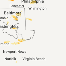
District of Columbia
| Local Time | Report Details |
|---|---|
| 7:10 PM UTC | Tree down in friendship heights are in district of columb county DC, 34 miles SW of Baltimore, MD |
| 7:12 PM UTC | Tree down on utah avenue northwest. blocking the roa in district of columb county DC, 32.8 miles SW of Baltimore, MD |
Mississippi
| Local Time | Report Details |
|---|---|
| 7:30 PM UTC | Couple trees and a power line down in bay springs in jasper county MS, 57.2 miles ESE of Jackson, MS |
| 8:35 PM UTC | Tree down blocking a railroad track in collins in covington county MS, 58.2 miles SE of Jackson, MS |
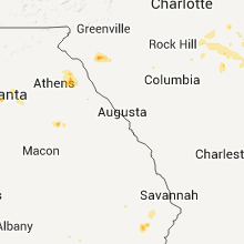
Georgia
| Local Time | Report Details |
|---|---|
| 8:05 PM UTC | The county dispatch center reported about 15 reports of trees blown down across the douglas area. the time of the report was based on radar imager in coffee county GA, 0.3 miles N of Douglas, GA |
| 10:29 PM UTC | Douglas county 911 relayed a report of a tree down in ese of fairplay. operator also relayed that they had reports of small penny sized hai in douglas county GA, 27.6 miles WSW of Atlanta, GA |
| 10:57 PM UTC | Several 4 to 5 inch tree limbs down on highway 119. time is estimated based on rada in liberty county GA, 38.1 miles SW of Savannah, GA |
| 11:59 PM UTC | 2 trees down across the roadwa in gwinnett county GA, 18.7 miles NE of Atlanta, GA |
| 12:40 AM UTC | Trees down along highway 172 mainly on the hart county side of the border. this reported by the elbert county communications cente in hart county GA, 47 miles SSW of Greenville, SC |
| 1:15 AM UTC | Meriwether county emergency management reported around a dozen downed trees in the rocky mount area along with some downed powerlines and dime sized hai in meriwether county GA, 43 miles SSW of Atlanta, GA |
| 1:40 AM UTC | Trees down in many parts of elbert county mainly the western and northern parts. indentified this location south of bowman due to highest velocities on radar at this ti in elbert county GA, 53 miles SSW of Greenville, SC |
| 2:30 AM UTC | Trees down in many parts of hart county. trees down in the hartwell area around 1030 pm. trees down just a few minutes earlier toward the reed creek area. trees likely in hart county GA, 38.1 miles SSW of Greenville, SC |
Alabama
| Local Time | Report Details |
|---|---|
| 8:05 PM UTC | Numerous trees down along several county roads in the southern part of the county...including in chilton county AL, 55.6 miles SSE of Birmingham, AL |
| 8:37 PM UTC | Several trees reported down along pinedale rd and the surrounding area. hail of at least nickel size was also reporte in chilton county AL, 47 miles SSE of Birmingham, AL |
| 8:43 PM UTC | Several trees reported down along pinedale rd and the surrounding area. hail of at least nickel size was also reported. corrected for tim in chilton county AL, 47 miles SSE of Birmingham, AL |
Louisiana
| Local Time | Report Details |
|---|---|
| 8:30 PM UTC | Couples trees down along hamburg road as well as crossett road up near the ashley county lin in morehouse county LA, 15.4 miles NE of Bastrop, LA |
Indiana
| Local Time | Report Details |
|---|---|
| 8:37 PM UTC | Roof blown off business and a few trees dow in ripley county IN, 40.6 miles WNW of Cincinnati, OH |
Oklahoma
| Local Time | Report Details |
|---|---|
| 8:50 PM UTC | Storm damage reported in washita county OK, 73.2 miles SSE of Woodward, OK |
| 8:55 PM UTC | Storm damage reported in washita county OK, 73.2 miles SSE of Woodward, OK |
Arkansas
| Local Time | Report Details |
|---|---|
| 9:05 PM UTC | Couple trees down east of meridian along highways 133 and 425 in ashley county AR, 17.3 miles N of Bastrop, LA |
Kentucky
| Local Time | Report Details |
|---|---|
| 9:27 PM UTC | Tree and power lines down on elwood ave. also a tree down on petersburg rd in h in boone county KY, 13 miles WSW of Cincinnati, OH |
| 1:30 AM UTC | Multiple trees down in the city of jackso in breathitt county KY, 34 miles ESE of Irvine, KY |
| 2:25 AM UTC | Several large limbs were blown down by a thunderstorm wind gust. the time of the event is estimated from radar imager in knott county KY, 63.1 miles ESE of Irvine, KY |
| 2:50 AM UTC | Several trees blown down...one landing on a vacant traile in rockcastle county KY, 20.8 miles SW of Irvine, KY |
West Virginia
| Local Time | Report Details |
|---|---|
| 10:45 PM UTC | ...correction for time and location...tree down near mile marker 99 of i-64 in charleston in kanawha county WV, 0.5 miles E of Charleston, WV |
| 10:51 PM UTC | Tree down on legg fork road...road is completely blocked in kanawha county WV, 10.3 miles N of Charleston, WV |
| 10:58 PM UTC | 4 to 5 trees down along lakeview dr. time estimated from rada in putnam county WV, 23.1 miles NW of Charleston, WV |
| 11:03 PM UTC | Tree down near mile marker 99 of i-64 in charleston in kanawha county WV, 3.9 miles W of Charleston, WV |
New Mexico
| Local Time | Report Details |
|---|---|
| 4:50 PM MDT | Quarter sized hail reported near Mountainair, NM, 37.4 miles SSE of Albuquerque, NM |
| 11:55 PM UTC | Ksrr awo in lincoln county NM, 59 miles W of Roswell, NM |
Montana
| Local Time | Report Details |
|---|---|
| 10:52 PM UTC | Storm damage reported in sweet grass county MT, 50.6 miles WNW of Billings, MT |
| 11:45 PM UTC | Storm damage reported in musselshell county MT, 37 miles NNW of Billings, MT |
| 12:00 AM UTC | Strong dust storms with this wind in yellowstone county MT, 21 miles WNW of Billings, MT |
| 12:30 AM UTC | Tin roof pulled off of shed type garage and was blown 30 yards. two wooden support posts were pulled out of the ground. winds estimated near 50 mp in beaverhead county MT, 45.5 miles ESE of Salmon, ID |
Massachusetts
| Local Time | Report Details |
|---|---|
| 11:50 PM UTC | Multiple trees down on route 116...road closed in hampshire county MA, 55.8 miles ESE of Schenectady, NY |
| 11:58 PM UTC | Multiple trees down on route 116...road closed in hampshire county MA, 55.8 miles ESE of Schenectady, NY |
| 11:58 PM UTC | Tree down on wires on route 116 in hampshire county MA, 55.8 miles ESE of Schenectady, NY |
South Carolina
| Local Time | Report Details |
|---|---|
| 12:40 AM UTC | Large branches down in belton as reported by publi in anderson county SC, 22.2 miles SSE of Greenville, SC |
| 9:05 PM EDT | Quarter sized hail reported near Pageland, SC, 40.2 miles SE of Charlotte, NC, mike yabo |
| 1:25 AM UTC | Sheriff dispatch reported a tree down on zoar road near highway in chesterfield county SC, 55.7 miles SE of Charlotte, NC |
| 1:32 AM UTC | Large tree down across sc highway 9. time estimated based off rada in marlboro county SC, 77.2 miles ESE of Charlotte, NC |
| 1:42 AM UTC | Sheriff dispatch reported trees down in chera in chesterfield county SC, 64.2 miles SE of Charlotte, NC |
| 1:45 AM UTC | Tree down on gravel pit road. time estimated based off rada in marlboro county SC, 81.2 miles SE of Charlotte, NC |
| 2:24 AM UTC | Sheriff dispatch reported trees down near mcbe in chesterfield county SC, 61.4 miles SSE of Charlotte, NC |
Arizona
| Local Time | Report Details |
|---|---|
| 1:30 AM UTC | Power poles downed at central highway and davis road. time based on radar in cochise county AZ, 18.9 miles NNW of Douglas, AZ |
Minnesota
| Local Time | Report Details |
|---|---|
| 5:10 AM UTC | Storm damage reported in rock county MN, 27.1 miles ENE of Sioux Falls, SD |
Iowa
| Local Time | Report Details |
|---|---|
| 12:10 AM CDT | Ping Pong Ball sized hail reported near Hull, IA, 39.3 miles SE of Sioux Falls, SD |
| 12:30 AM CDT | Ping Pong Ball sized hail reported near Boyden, IA, 44.3 miles ESE of Sioux Falls, SD |
| 2:45 AM CDT | Golf Ball sized hail reported near Glenwood, IA, 17.7 miles SE of Omaha, NE, quarter to golfball sized hail. |
| 4:15 AM CDT | Golf Ball sized hail reported near Glenwood, IA, 24.5 miles SE of Omaha, NE |
| 9:50 AM UTC | 3-4 inch limbs dow in fremont county IA, 41 miles SE of Omaha, NE |
Missouri
| Local Time | Report Details |
|---|---|
| 6:27 AM CDT | Golf Ball sized hail reported near Rock Port, MO, 61.4 miles SSE of Omaha, NE |
Connect with Interactive Hail Maps