

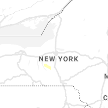
Hail Map for Tuesday, August 25, 2020

Number of Impacted Households on 8/25/2020
0
Impacted by 1" or Larger Hail
0
Impacted by 1.75" or Larger Hail
0
Impacted by 2.5" or Larger Hail
Square Miles of Populated Area Impacted on 8/25/2020
0
Impacted by 1" or Larger Hail
0
Impacted by 1.75" or Larger Hail
0
Impacted by 2.5" or Larger Hail


Cities Most Affected by Hail Storms of 8/25/2020
| Hail Size | Demographics of Zip Codes Affected | ||||||
|---|---|---|---|---|---|---|---|
| City | Count | Average | Largest | Pop Density | House Value | Income | Age |
Hail and Wind Damage Spotted on 8/25/2020
Filter by Report Type:Hail ReportsWind Reports
States Impacted
Pennsylvania, Wisconsin, Virginia, New York, Ohio, Maine, New Hampshire, West Virginia, Indiana, Vermont, New Jersey, Maryland, Idaho, Connecticut, Massachusetts, Kentucky, Rhode Island, Montana, District of Columbia, Wyoming, MichiganPennsylvania
| Local Time | Report Details |
|---|---|
| 8:17 AM EDT | Trees down at 125 ashbaugh r in westmoreland county PA, 21.8 miles ESE of Pittsburgh, PA |
| 8:25 AM EDT | Tree reported down along route 119 near country farms garden cente in westmoreland county PA, 25.7 miles ESE of Pittsburgh, PA |
| 8:40 AM EDT | Power lines reported dow in westmoreland county PA, 37.2 miles ESE of Pittsburgh, PA |
| 8:40 AM EDT | Corrects previous tstm wnd dmg report from 4 w acosta. multiple trees down at maggie rd and keysertown r in somerset county PA, 51.6 miles ESE of Pittsburgh, PA |
| 9:15 AM EDT | Trees down at 125 ashbaugh r in westmoreland county PA, 21.8 miles ESE of Pittsburgh, PA |
| 1:33 PM EDT | Trees and wires down in washington township in butler county PA, 43.3 miles NNE of Pittsburgh, PA |
| 1:40 PM EDT | Trees and wires down; power out near fairview are in butler county PA, 41.7 miles NNE of Pittsburgh, PA |
| 1:47 PM EDT | Quarter sized hail reported near Chicora, PA, 37.8 miles NNE of Pittsburgh, PA |
| 1:50 PM EDT | Armstrong 911 reports trees down all across northern armstrong count in armstrong county PA, 39 miles NNE of Pittsburgh, PA |
| 1:55 PM EDT | Large trees down and split in half... and laying on power lines in cowansville pa in armstrong county PA, 37.8 miles NE of Pittsburgh, PA |
| 2:01 PM EDT | Trees and power lines reported down in worthington pa in armstrong county PA, 33.8 miles NE of Pittsburgh, PA |
| 2:47 PM EDT | Half Dollar sized hail reported near Saltsburg, PA, 33.1 miles ENE of Pittsburgh, PA |
| 2:52 PM EDT | Estimated near 10 trees down at residence with additional trees down in the neighborhood. metal also ripped off shed roofin in indiana county PA, 40.1 miles E of Pittsburgh, PA |
| 3:03 PM EDT | Tree reported down off deep hollow rd in westmoreland county PA, 36.3 miles E of Pittsburgh, PA |
| 3:05 PM EDT | Power line down on the 800 block of pittsburgh st in westmoreland county PA, 34.6 miles E of Pittsburgh, PA |
| 3:05 PM EDT | Tree down on 200 block of garrigan hill rd in westmoreland county PA, 35.3 miles E of Pittsburgh, PA |
| 3:15 PM EDT | Multiple trees down in fairfield township in westmoreland county PA, 45.9 miles E of Pittsburgh, PA |
| 3:16 PM EDT | Trees down on power lines in derry township by route 981 and shortcut rd in westmoreland county PA, 31 miles E of Pittsburgh, PA |
| 3:18 PM EDT | Several trees and power lines reported down in and around hopewell township in beaver county PA, 17.8 miles NW of Pittsburgh, PA |
| 3:30 PM EDT | Tree down on wire in cambria county PA, 59.7 miles ESE of Pittsburgh, PA |
| 3:30 PM EDT | Wires dow in somerset county PA, 54.4 miles ESE of Pittsburgh, PA |
| 3:35 PM EDT | Tree down blocking both lanes of roadwa in somerset county PA, 58.4 miles ESE of Pittsburgh, PA |
| 3:35 PM EDT | Tree on wires near intersection of view ave and forest lan in somerset county PA, 53.1 miles ESE of Pittsburgh, PA |
| 3:38 PM EDT | Tree reported down near intersection of wilpen rd and ramsey rd in westmoreland county PA, 44 miles ESE of Pittsburgh, PA |
| 3:45 PM EDT | Tree down across roadwa in somerset county PA, 60.3 miles ESE of Pittsburgh, PA |
| 4:00 PM EDT | Tree down at allegheny rd and geller r in bedford county PA, 74.1 miles ESE of Pittsburgh, PA |
| 4:15 PM EDT | Trees and power lines down in cook township off linn run r in westmoreland county PA, 44.9 miles ESE of Pittsburgh, PA |
| 4:29 PM EDT | Several trees reported down in mount pleasant township in westmoreland county PA, 31.3 miles SE of Pittsburgh, PA |
| 5:08 PM EDT | Tree down on 200 block of porter ave in rostraver township in westmoreland county PA, 24.1 miles SSE of Pittsburgh, PA |
Wisconsin
| Local Time | Report Details |
|---|---|
| 7:25 AM CDT | Quarter sized hail reported near Oxford, WI, 51.1 miles NNW of Madison, WI, reported from meteorologist 5 miles west of oxford wi. |
| 1:49 PM CDT | Half Dollar sized hail reported near Berlin, WI, 61.2 miles SW of Green Bay, WI, near county road v and state road 49. |
Virginia
| Local Time | Report Details |
|---|---|
| 11:16 AM EDT | Tree reported down on the 4000 block of shepherds mill roa in clarke county VA, 70.6 miles W of Baltimore, MD |
| 11:30 AM EDT | Tree reported down on the 9400 block of lord fairfax highwa in clarke county VA, 77.4 miles W of Baltimore, MD |
| 11:30 AM EDT | Tree reported down on river road near saw mill hill roa in clarke county VA, 71 miles W of Baltimore, MD |
| 11:47 AM EDT | Powerlines down near the intersection of route 50 and mount carmel road in clarke county VA, 75.8 miles WSW of Baltimore, MD |
| 12:22 PM EDT | Tree down on airmont road near yatton roa in loudoun county VA, 63.4 miles W of Baltimore, MD |
| 5:36 PM EDT | Tree down in 1400 block of north sleepy creek roa in frederick county VA, 87.5 miles ENE of Elkins, WV |
| 6:14 PM EDT | Tree damage in clarke county VA, 79 miles W of Baltimore, MD |
| 6:25 PM EDT | Tree down near intersection of chapel road and hites road. tree down on veterans road in frederick county VA, 84.1 miles E of Elkins, WV |
| 6:28 PM EDT | Tree down near the intersection of va-733 mountville road and va-734 snickersville turnpik in loudoun county VA, 62 miles WSW of Baltimore, MD |
| 6:34 PM EDT | Tree down near the intersection of va-734 snickersville turnpike and va-650 oatlands roa in loudoun county VA, 60.1 miles WSW of Baltimore, MD |
| 6:35 PM EDT | Numerous trees down across the southern portion of clarke county including the cities of berryville and white post in clarke county VA, 78.4 miles W of Baltimore, MD |
| 6:37 PM EDT | Trees down on us-50 lee jackson memorial highway just west of us-15 james monroe highwa in loudoun county VA, 59.1 miles WSW of Baltimore, MD |
| 6:44 PM EDT | Downed tree on mountain rd in prince william county VA, 62.6 miles WSW of Baltimore, MD |
| 6:52 PM EDT | Tree down on leeds manor roa in fauquier county VA, 80.2 miles WSW of Baltimore, MD |
| 6:54 PM EDT | Multiple reports of trees and wires down across southern portions of warren count in warren county VA, 87.4 miles E of Elkins, WV |
| 7:04 PM EDT | Multiple reports of trees and wires down in washingto in rappahannock county VA, 87.7 miles NNW of Richmond, VA |
| 7:05 PM EDT | Multiple reports of trees and wires down near warrento in fauquier county VA, 75.2 miles WSW of Baltimore, MD |
| 7:11 PM EDT | Multiple reports of trees and wires down in amissvill in rappahannock county VA, 82.7 miles NNW of Richmond, VA |
| 7:12 PM EDT | Multiple reports of trees and wires down in woodvill in rappahannock county VA, 81.6 miles NNW of Richmond, VA |
| 7:20 PM EDT | Multiple reports of trees and wires down throughout culpeper count in culpeper county VA, 76.2 miles NNW of Richmond, VA |
| 7:20 PM EDT | Trees down near the intersection of blair road and pinetree terrac in fairfax county VA, 41.7 miles SW of Baltimore, MD |
| 7:24 PM EDT | Multiple reports of trees and wires down near bealeto in fauquier county VA, 73.8 miles N of Richmond, VA |
| 7:41 PM EDT | Downed tree near mt olive rd and poplar rd in stafford county VA, 63.5 miles N of Richmond, VA |
| 7:45 PM EDT | Downed tree on i-95 near mm 150 in city of manassas county VA, 60.3 miles SW of Baltimore, MD |
| 7:45 PM EDT | Downed tree on i-95 near mm 150 in prince william county VA, 64.5 miles SW of Baltimore, MD |
| 7:45 PM EDT | Downed tree near neabsco rd and macedonia d in prince william county VA, 59.2 miles SW of Baltimore, MD |
| 7:51 PM EDT | Downed tree on i-95 near mm 141 in stafford county VA, 65.1 miles N of Richmond, VA |
| 8:03 PM EDT | Downed tree on white oak rd in stafford county VA, 57.3 miles NNE of Richmond, VA |
| 8:18 PM EDT | Tree down on power-line along midland trail near the marathon gas station in callagha in alleghany county VA, 37.8 miles N of Roanoke, VA |
New York
| Local Time | Report Details |
|---|---|
| 1:23 PM EDT | Trees and wires down along cobb stree in tompkins county NY, 35.1 miles SSW of Syracuse, NY |
| 1:39 PM EDT | Wires down at ferguson and south street in tompkins county NY, 40.1 miles S of Syracuse, NY |
| 2:10 PM EDT | Quarter sized hail reported near Oneonta, NY, 63.4 miles WSW of Schenectady, NY |
| 2:13 PM EDT | Tree on the powerlines across dunham hill road in broome county NY, 55.8 miles S of Syracuse, NY |
| 2:16 PM EDT | Tree down across road at caldwell hills road and treiber riad in broome county NY, 52.6 miles S of Syracuse, NY |
| 2:59 PM EDT | Trees and wires reported down on route 6 in bovina in delaware county NY, 55.1 miles SW of Schenectady, NY |
| 3:15 PM EDT | Tree and wires down along park av in saratoga county NY, 14.1 miles ENE of Schenectady, NY |
| 4:50 PM EDT | Tree down on wires in chelse in dutchess county NY, 59.2 miles N of Brooklyn, NY |
| 4:55 PM EDT | Wires down on fishkill r in dutchess county NY, 56.5 miles N of Brooklyn, NY |
| 6:12 PM EDT | Large tree branch down on hoe ave in the longwood section of the bron in bronx county NY, 12.6 miles NNE of Brooklyn, NY |
| 6:30 PM EDT | Tree on house at 82-36 beverly roa in queens county NY, 10.6 miles E of Brooklyn, NY |
| 7:07 PM EDT | Great gull island...elevation 53 fee in suffolk county NY, 56.6 miles SW of Providence, RI |
Ohio
| Local Time | Report Details |
|---|---|
| 1:55 PM EDT | Quarter sized hail reported near Fairborn, OH, 50.1 miles W of Columbus, OH |
| 2:28 PM EDT | Trees and power lines down in west lafeytte in coshocton county OH, 69.7 miles ENE of Columbus, OH |
| 2:50 PM EDT | Quarter sized hail reported near Flushing, OH, 60.5 miles WSW of Pittsburgh, PA |
| 2:53 PM EDT | Roof blown off barn on zimmerman road. time estimated from radar dat in greene county OH, 44.2 miles SW of Columbus, OH |
| 3:07 PM EDT | Several trees down in and around warsaw village with power lines also down from trees laying on the in coshocton county OH, 59.2 miles ENE of Columbus, OH |
| 3:17 PM EDT | Pole down at ohio 72 and black road. time estimated from radar dat in clinton county OH, 48.6 miles SW of Columbus, OH |
| 3:17 PM EDT | Semi trailer blown over on us-22 near reed road. time estimated from rada in clinton county OH, 49.9 miles SW of Columbus, OH |
| 3:30 PM EDT | Muskingum ema reports damage across much of the county including trees and powerlines down around intersection of norfield rd and state route 9 in muskingum county OH, 57 miles E of Columbus, OH |
| 3:45 PM EDT | Numerous trees down in the town of somerse in perry county OH, 38.8 miles ESE of Columbus, OH |
| 3:52 PM EDT | One 10-12 inch tree limb downed. time estimated from rada in clinton county OH, 42.7 miles NE of Cincinnati, OH |
| 4:00 PM EDT | Half Dollar sized hail reported near Wilmington, OH, 42.7 miles NE of Cincinnati, OH |
| 4:00 PM EDT | Tree down on house and lines. time estimated from radar dat in clinton county OH, 42.3 miles NE of Cincinnati, OH |
| 4:01 PM EDT | Large limb blown down. time estimated from radar dat in clinton county OH, 43.6 miles NE of Cincinnati, OH |
| 4:02 PM EDT | Multiple reports of trees down across county. most reports were from the logan are in hocking county OH, 43.3 miles SE of Columbus, OH |
| 4:02 PM EDT | Three mature trees downed near county line and hempstead roa in franklin county OH, 13 miles NNE of Columbus, OH |
| 4:02 PM EDT | Tree down in road. time estimated from radar dat in clinton county OH, 43.7 miles ENE of Cincinnati, OH |
| 4:02 PM EDT | Tree down on car. time estimated from radar dat in clinton county OH, 42.8 miles NE of Cincinnati, OH |
| 4:06 PM EDT | Several large branches down... blocking road. time estimated from rada in morgan county OH, 59.4 miles ESE of Columbus, OH |
| 4:28 PM EDT | Three trees and many branches down. time estimated from radar dat in franklin county OH, 12.1 miles ENE of Columbus, OH |
| 4:30 PM EDT | Numerous trees dow in perry county OH, 46.6 miles ESE of Columbus, OH |
| 4:34 PM EDT | Two trees... several large limbs blown down. time estimated from radar dat in fairfield county OH, 14.1 miles ESE of Columbus, OH |
| 4:37 PM EDT | Several trees down in far southwest portion of athens township... some blocking roads. time esitmated from caller information and rada in athens county OH, 65.5 miles SE of Columbus, OH |
| 4:41 PM EDT | Several trees down... some blocking roads. time estiamted from call center time and rada in athens county OH, 66.5 miles SE of Columbus, OH |
| 4:45 PM EDT | Numerous trees down around tow in perry county OH, 36.6 miles E of Columbus, OH |
| 4:50 PM EDT | Measured on home weather statio in butler county OH, 17.9 miles NNE of Cincinnati, OH |
| 5:07 PM EDT | Trees dow in meigs county OH, 53 miles NNW of Charleston, WV |
| 5:15 PM EDT | Multiple trees dow in athens county OH, 60.6 miles N of Charleston, WV |
| 5:24 PM EDT | One 20 inch diameter tree snapped. another 8 inch diameter tree limb downed. time estimated from rada in clermont county OH, 17.9 miles ENE of Cincinnati, OH |
| 5:35 PM EDT | Spotter relayed report from a judge of several trees down. time and location vectored from spotter information and rada in perry county OH, 33.3 miles E of Columbus, OH |
Maine
| Local Time | Report Details |
|---|---|
| 2:30 PM EDT | Trees and wires down in norway and waterford. time estimated from rada in oxford county ME, 41.4 miles NNW of Portland, ME |
| 2:40 PM EDT | Trees and wires down hinckley rd clinto in kennebec county ME, 40.9 miles WSW of Bangor, ME |
| 2:48 PM EDT | Trees across power lines on old kents hill rd and thunder castle rd. time estimated by rada in kennebec county ME, 52.3 miles NNE of Portland, ME |
| 2:50 PM EDT | Trees down in backyard off of route 17. time estimated from rada in kennebec county ME, 53.3 miles NNE of Portland, ME |
| 3:00 PM EDT | Multiple trees down along rt 13 in kennebec county ME, 55.5 miles NNE of Portland, ME |
| 3:05 PM EDT | Tree and wires down reported on prescott r in kennebec county ME, 52.5 miles NNE of Portland, ME |
| 3:05 PM EDT | Trees down on rt 11 blocking one lan in androscoggin county ME, 30.6 miles NNW of Portland, ME |
| 3:15 PM EDT | Corrects source of previous tstm wnd dmg report from jackson. report of a tree down in jackson. time estimated from rada in waldo county ME, 21.3 miles SW of Bangor, ME |
| 3:15 PM EDT | Corrects source of previous tstm wnd dmg report from jackson. report of a tree down in jackson. time estimated from rada in waldo county ME, 21.3 miles SW of Bangor, ME |
| 3:20 PM EDT | Tree on power line on main roa in penobscot county ME, 11.5 miles NE of Bangor, ME |
| 3:20 PM EDT | Umo pd reports 2 trees down on campus blocking roads. numerous power outages in the are in penobscot county ME, 8.4 miles NE of Bangor, ME |
| 3:20 PM EDT | Photo via social media of large tree dow in penobscot county ME, 11.2 miles NNE of Bangor, ME |
| 3:23 PM EDT | Tree down not blocking roadwa in penobscot county ME, 0.8 miles NE of Bangor, ME |
| 3:25 PM EDT | Report of a tree down in monroe. time estimated from rada in waldo county ME, 17.5 miles SW of Bangor, ME |
| 3:25 PM EDT | Tree down on vehicle reported on brunswick ave. delayed report. time estimated from rada in kennebec county ME, 43.5 miles NNE of Portland, ME |
| 3:45 PM EDT | Tree down on wires on west appleton rd. time estimated from rada in knox county ME, 40.5 miles SW of Bangor, ME |
| 3:59 PM EDT | Several trees & power lines down in tow in hancock county ME, 18.6 miles ESE of Bangor, ME |
| 4:00 PM EDT | Corrects source of previous tstm wnd dmg report from nobleboro. tree down and blocking roadway on center st. time estimated from rada in lincoln county ME, 48.1 miles NE of Portland, ME |
| 4:10 PM EDT | Corrects time of previous tstm wnd dmg report from waterboro. reports of downed trees blocking roadways in the waterboro area. time estimated from rada in york county ME, 24.7 miles WSW of Portland, ME |
| 4:12 PM EDT | Tree down and blocking roadway. reported at 396 beach hill rd... jefferson... m in lincoln county ME, 54 miles SW of Bangor, ME |
| 4:15 PM EDT | Trees down on sr 3 in lincoln county ME, 44.3 miles ENE of Portland, ME |
| 4:16 PM EDT | Several trees & power lines down in ellsworth. power it out in many location in hancock county ME, 25 miles SE of Bangor, ME |
| 4:20 PM EDT | Corrects source of previous tstm wnd dmg report from 1 ene thomaston. tree down and blocking roadway on old county rd. time estimated from rada in knox county ME, 53 miles SSW of Bangor, ME |
| 4:20 PM EDT | Corrects source of previous tstm wnd dmg report from 1 ene thomaston. tree down and blocking roadway on old county rd. time estimated from rada in knox county ME, 53 miles SSW of Bangor, ME |
| 4:30 PM EDT | Trees and branches down all over town. power ou in knox county ME, 54.9 miles SSW of Bangor, ME |
| 4:33 PM EDT | Trees down on dutch elm golf course. reported via twitter. time estimated from rada in york county ME, 19.8 miles SW of Portland, ME |
| 4:40 PM EDT | Corrects time of previous report. telephone poll snapped on seagrass lan in york county ME, 13.5 miles SSW of Portland, ME |
| 6:08 PM EDT | Telephone poll snapped on seagrass lan in york county ME, 13.5 miles SSW of Portland, ME |
New Hampshire
| Local Time | Report Details |
|---|---|
| 3:10 PM EDT | Tree down on mayhew turnpike. wires down on hemlock brook rd. also reports of multiple trees on wires in the bridgewater area from facebook. time estimated from rada in grafton county NH, 74.4 miles W of Portland, ME |
| 3:15 PM EDT | Multiple reports of trees on wires. also reported via facebook. time estimated from rada in grafton county NH, 74.5 miles W of Portland, ME |
| 4:20 PM EDT | Trees down on chemical ln. delayed report. time estimated from rada in merrimack county NH, 83.3 miles WSW of Portland, ME |
| 4:40 PM EDT | Multiple trees on wires in the area. delayed report. time estimated from rada in rockingham county NH, 59.9 miles SW of Portland, ME |
West Virginia
| Local Time | Report Details |
|---|---|
| 3:35 PM EDT | Several trees reported down in moundsville wv... along with non-specific roof damage in marshall county WV, 53.1 miles SW of Pittsburgh, PA |
| 4:01 PM EDT | Multiple trees and power lines reported down across the count in wetzel county WV, 70.5 miles SW of Pittsburgh, PA |
| 4:07 PM EDT | Trees and powerlines reported down in monongalia county WV, 55.2 miles SSW of Pittsburgh, PA |
| 4:22 PM EDT | Marion 911 reports several large trees down and trees down on power lines through the county... including the town of fairvie in marion county WV, 50.8 miles NNW of Elkins, WV |
| 4:25 PM EDT | Marion 911 reports several large trees down and trees down on power lines through the county... including the town of grant tow in marion county WV, 47.4 miles NNW of Elkins, WV |
| 4:29 PM EDT | Marion 911 reports several large trees down and trees down on power lines through the county... including the town of rivesvill in marion county WV, 44.3 miles NNW of Elkins, WV |
| 4:40 PM EDT | Tree down near the intersection of canal parkway and industrial blvd in allegany county MD, 75.9 miles NE of Elkins, WV |
| 4:56 PM EDT | Tree down near the intersection of powerhouse road and cacapon road in morgan county WV, 84.5 miles SSW of State College, PA |
| 5:00 PM EDT | Few trees down... blocking roads. time estiamted from rada in taylor county WV, 28.4 miles NNW of Elkins, WV |
| 5:08 PM EDT | Tree down and wires down on the 2000 block of young blood road in morgan county WV, 89 miles SSW of State College, PA |
| 5:11 PM EDT | Numerous trees and power lines dow in ritchie county WV, 65.6 miles NNE of Charleston, WV |
| 5:15 PM EDT | Numerous trees down in nestorville and elsewhere in barbour county. time for nestorville estimated from rada in barbour county WV, 18 miles N of Elkins, WV |
| 5:16 PM EDT | Quarter sized hail reported near Rowlesburg, WV, 28.2 miles NNE of Elkins, WV |
| 5:26 PM EDT | *** 1 inj *** numerous trees down across the county with power outages. a women had a head injury from a downed tree and several roads were blocked due to tree in harrison county WV, 36.2 miles WNW of Elkins, WV |
| 5:28 PM EDT | At least 2 trees down along roadway in the town of meadowbroo in harrison county WV, 38.9 miles NW of Elkins, WV |
| 5:28 PM EDT | Tree down on the 13000 block of fort asby road in mineral county WV, 64.6 miles NE of Elkins, WV |
| 5:31 PM EDT | Powerline pole down on the 7000 block of sonnybrook lane in mineral county WV, 59.4 miles NE of Elkins, WV |
| 5:32 PM EDT | Tree down on henry dobbin highway near east portal road in grant county WV, 29.4 miles NE of Elkins, WV |
| 5:36 PM EDT | Multiple reports of trees and wires down in romne in hampshire county WV, 65.3 miles ENE of Elkins, WV |
| 5:40 PM EDT | Trees down around the town of lucil in wirt county WV, 42.9 miles NNE of Charleston, WV |
| 5:43 PM EDT | A tree was blown down onto us-50 northwestern pike near trojan wa in hampshire county WV, 67.6 miles ENE of Elkins, WV |
| 5:48 PM EDT | Tree down and wires down on the 1500 block of river road in morgan county WV, 79.1 miles S of State College, PA |
| 5:55 PM EDT | Multiple reports of trees and wires down across southeastern hampshire county in hampshire county WV, 69.4 miles ENE of Elkins, WV |
| 6:10 PM EDT | Trees down in mason county WV, 49.8 miles NNW of Charleston, WV |
| 6:16 PM EDT | Several trees down over tucker ridge rd. buffalo wv in putnam county WV, 27.3 miles NW of Charleston, WV |
| 6:30 PM EDT | Several trees down and an outbuilding damged/lost. time estimated from caller and rada in putnam county WV, 18.1 miles NNW of Charleston, WV |
| 6:30 PM EDT | Emergency services director from wallback called in a strong storm producing 60kt gusts which immediately dropped down to 20k in clay county WV, 31.2 miles ENE of Charleston, WV |
| 6:35 PM EDT | Tree down blocking ivydale road and another down blocking ivydale ridge road. time estimated from caller information and rada in clay county WV, 31.3 miles ENE of Charleston, WV |
| 6:35 PM EDT | Tree down blocking ivydale road and another down blocking ivydale ridge road. time estimated from caller information and rada in clay county WV, 36.3 miles ENE of Charleston, WV |
| 6:35 PM EDT | Several trees down and power out in the beverly hills neighborhood. time estimated from caller and rada in cabell county WV, 43.1 miles W of Charleston, WV |
| 6:36 PM EDT | Two trees down on elk river road. time corroborated via rada in kanawha county WV, 10.7 miles ENE of Charleston, WV |
| 6:41 PM EDT | A few trees and large tree limbs down in cabell county WV, 43.1 miles W of Charleston, WV |
| 6:45 PM EDT | Several reports of a single tree down in various locations in and around clay... including a tree with power lines down at 819 dog run road and and a tree down between in clay county WV, 31.3 miles ENE of Charleston, WV |
| 7:16 PM EDT | Tree dow in kanawha county WV, 13.3 miles SE of Charleston, WV |
| 7:23 PM EDT | Numerous small trees down and one large tree down completely blocking off boonesborough r in fayette county WV, 27.3 miles SE of Charleston, WV |
| 7:25 PM EDT | Tree down. time estimated from rada in kanawha county WV, 16.6 miles SE of Charleston, WV |
| 7:25 PM EDT | Tree dow in kanawha county WV, 17.6 miles SE of Charleston, WV |
| 7:26 PM EDT | A couple trees down along scarbro r in fayette county WV, 38 miles SE of Charleston, WV |
| 7:33 PM EDT | Tree down across simms mountain road near rt. 20 heading toward lilly par in greenbrier county WV, 53.7 miles ESE of Charleston, WV |
| 7:34 PM EDT | Tree down at the intersection of kieffer rd. and deitz r in greenbrier county WV, 59.6 miles NW of Roanoke, VA |
| 7:38 PM EDT | Tree and power-line down in the vicinity of us 219 at spring creek station roa in greenbrier county WV, 54.6 miles NNW of Roanoke, VA |
| 8:35 PM EDT | Trees down in glen rogers roa in wyoming county WV, 45.1 miles SSE of Charleston, WV |
| 8:57 PM EDT | Trees down in koppersto in wyoming county WV, 41.6 miles S of Charleston, WV |
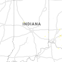
Indiana
| Local Time | Report Details |
|---|---|
| 4:02 PM EDT | Multiple reports of trees down across county. most reports were from the logan are in dearborn county IN, 22.9 miles WNW of Cincinnati, OH |
| 4:49 PM EDT | Tree down on old sr-101 near franklin-union county line. time estimated from radar dat in union county IN, 38.2 miles NW of Cincinnati, OH |
| 5:08 PM EDT | Large tree down over road. time estimated from radar dat in franklin county IN, 39.3 miles NW of Cincinnati, OH |
Vermont
| Local Time | Report Details |
|---|---|
| 4:25 PM EDT | Tree down on interstate 91 northboun in windsor county VT, 85.7 miles ENE of Schenectady, NY |
New Jersey
| Local Time | Report Details |
|---|---|
| 4:55 PM EDT | High point monumen in sussex county NJ, 52.4 miles E of Scranton, PA |
| 5:17 PM EDT | Multiple trees down in the upper greenwood lake area near lake shore dr. and riverside rd. time estimated by rada in passaic county NJ, 39.7 miles NNW of Brooklyn, NY |
| 5:45 PM EDT | Large (8-10 inch) tree limb down across road at winters stree in bergen county NJ, 26.7 miles NNW of Brooklyn, NY |
| 6:09 PM EDT | At weisch lane... tree down on utility pole in bergen county NJ, 23.2 miles NNW of Brooklyn, NY |
| 6:09 PM EDT | At weisch lane... tree down on utility pole in bergen county NJ, 23.2 miles NNW of Brooklyn, NY |
| 6:09 PM EDT | At weisch lane... tree down on utility pole in bergen county NJ, 23.2 miles NNW of Brooklyn, NY |
| 6:15 PM EDT | Tree on house along knollwood roa in bergen county NJ, 24.7 miles NNW of Brooklyn, NY |
| 6:15 PM EDT | Live power lines down on ground on west englewood road in bergen county NJ, 13.7 miles N of Brooklyn, NY |
| 6:25 PM EDT | Branches and wires down. time estimated from rada in cumberland county NJ, 70.7 miles E of Baltimore, MD |
| 6:54 PM EDT | Quarter sized hail reported near Newport, NJ, 66.7 miles N of Ocean City, MD, dime to quarter size hail stones. |
| 7:00 PM EDT | Nj mesonet gus in cumberland county NJ, 62.6 miles N of Ocean City, MD |
| 7:05 PM EDT | Njweathernet site nj67; gust followed a previous 65 mph gus in cumberland county NJ, 62.6 miles N of Ocean City, MD |
Maryland
| Local Time | Report Details |
|---|---|
| 4:56 PM EDT | Tree down on the 10000 block of mount savage road in allegany county MD, 77.4 miles NE of Elkins, WV |
| 6:04 PM EDT | Tree and wires down at north east rd. and nazarene camp rd. time estimated from rada in cecil county MD, 42 miles ENE of Baltimore, MD |
| 6:05 PM EDT | Multiple reports of wires and trees down around north east. time estimated from rada in cecil county MD, 41.7 miles ENE of Baltimore, MD |
| 6:10 PM EDT | Storm damage reported in cecil county MD, 43.1 miles ENE of Baltimore, MD |
| 6:13 PM EDT | 80 ft walnut tree uprooted in elkmore. also had pea-sized hail. time estimated from rada in cecil county MD, 44.3 miles ENE of Baltimore, MD |
| 7:43 PM EDT | Tree fell on a house located on pritchard ln in prince georges county MD, 30.9 miles SSW of Baltimore, MD |
| 8:25 PM EDT | Storm damage reported in anz540 county MD, 35.2 miles SE of Baltimore, MD |
| 8:25 PM EDT | Storm damage reported in queen anne's county MD, 33.7 miles SE of Baltimore, MD |
| 9:14 PM EDT | Report of a tree blown down in denton. time estimated from rada in caroline county MD, 50.2 miles ESE of Baltimore, MD |
| 9:30 PM EDT | Tree down. time estimated from radar dat in wicomico county MD, 35.7 miles W of Ocean City, MD |
| 9:55 PM EDT | Tree down near the intersection of route 13 and stewart neck road. time estimated from radar dat in somerset county MD, 34.9 miles WSW of Ocean City, MD |
Idaho
| Local Time | Report Details |
|---|---|
| 3:09 PM MDT | Usfs raws system - cotton ridge in cassia county ID, 31.7 miles SSE of Twin Falls, ID |
| 3:22 PM MDT | Power outage from passing thunderstorm in cassia county ID, 69.1 miles ESE of Twin Falls, ID |
| 3:45 PM MDT | Itd yale observation system in cassia county ID, 47 miles E of Twin Falls, ID |
| 4:30 PM MDT | Itd tomcat observation system in butte county ID, 72.4 miles NE of Twin Falls, ID |
| 4:48 PM MDT | Tree down. time estimated based on radar and nearby wind gust report in bannock county ID, 49.3 miles SSW of Idaho Falls, ID |
| 4:54 PM MDT | Raws potter butte in blaine county ID, 71.5 miles NE of Twin Falls, ID |
| 5:00 PM MDT | Inl arl frd - coxs well in butte county ID, 64.2 miles W of Idaho Falls, ID |
| 5:00 PM MDT | Itd topaz observation in bannock county ID, 60.2 miles S of Idaho Falls, ID |
| 5:00 PM MDT | 4 large stadium light poles snapped off at their bases and down damaging a chain link fence at butte county high school. wires also down. report from county em confirme in butte county ID, 63.9 miles W of Idaho Falls, ID |
| 5:00 PM MDT | Butte county emergency manager reports numerous tree limbs down across the moore and arco areas... along with reports of power outages in rural portions of butte county in butte county ID, 66.6 miles WNW of Idaho Falls, ID |
| 5:10 PM MDT | Inl arl frd - dean man canyon in butte county ID, 49 miles WNW of Idaho Falls, ID |
| 5:23 PM MDT | Numerous power outages including pocatello... chubbuck... mccammon... lava hot springs... virginia... springfield in bannock county ID, 47.5 miles SSW of Idaho Falls, ID |
| 5:25 PM MDT | Inl arl frd observation in butte county ID, 45.6 miles W of Idaho Falls, ID |
| 5:30 PM MDT | Itd inl puzzle - central facilities in butte county ID, 49.4 miles W of Idaho Falls, ID |
| 5:40 PM MDT | Inl arl frd - sand dunes in butte county ID, 43.8 miles WNW of Idaho Falls, ID |
| 5:45 PM MDT | Itd - telegraph hill in bonneville county ID, 0.2 miles SE of Idaho Falls, ID |
| 5:45 PM MDT | Inl arl frd - spec manufacturing lof in butte county ID, 47.9 miles NW of Idaho Falls, ID |
Connecticut
| Local Time | Report Details |
|---|---|
| 5:51 PM EDT | Large tree down near a home in westport... ct. time estimated by rada in fairfield county CT, 45.2 miles NE of Brooklyn, NY |
| 5:59 PM EDT | Wires down on prospect street in tolland county CT, 46 miles W of Providence, RI |
| 6:01 PM EDT | Tree and wires down on basetts bridge road in tolland county CT, 43.3 miles W of Providence, RI |
| 6:08 PM EDT | Trees down and transformer fire on brooklyn turnpike in windham county CT, 33.1 miles W of Providence, RI |
| 6:15 PM EDT | Tree down on a house on franklin street in windham county CT, 24.2 miles W of Providence, RI |
Massachusetts
| Local Time | Report Details |
|---|---|
| 6:04 PM EDT | Multiple trees and wires down on green hill road in franklin county MA, 74.2 miles E of Schenectady, NY |
| 6:05 PM EDT | Tree down on old state road in franklin county MA, 73.8 miles NW of Providence, RI |
Kentucky
| Local Time | Report Details |
|---|---|
| 6:23 PM EDT | Storm damage reported in boone county KY, 9.2 miles WSW of Cincinnati, OH |
Rhode Island
| Local Time | Report Details |
|---|---|
| 6:45 PM EDT | Tree down on south road in washington county RI, 22.3 miles SW of Providence, RI |
| 6:57 PM EDT | Tree and wires down on yawgoo valley road road in washington county RI, 22.3 miles SW of Providence, RI |
Montana
| Local Time | Report Details |
|---|---|
| 5:31 PM MDT | Storm damage reported in beaverhead county MT, 66 miles E of Salmon, ID |
| 7:15 PM MDT | Storm damage reported in wheatland county MT, 58 miles NW of Billings, MT |
| 8:45 PM MDT | Storm damage reported in yellowstone county MT, 2.8 miles NW of Billings, MT |
| 9:32 PM MDT | Asos station kjdn jorda in garfield county MT, 61.5 miles SSW of Glasgow, MT |
District of Columbia
| Local Time | Report Details |
|---|---|
| 7:32 PM EDT | Tree down near the intersection of 27th street northeast and vista street northeas in district of columb county DC, 31.5 miles SW of Baltimore, MD |
Wyoming
| Local Time | Report Details |
|---|---|
| 6:52 PM MDT | Mesonet station krec atlantic city 10 ne (wydot in fremont county WY, 30.3 miles SSW of Riverton, WY |
| 7:18 PM MDT | Awos station kjac jackson hole airpor in teton county WY, 66.4 miles E of Idaho Falls, ID |
Michigan
| Local Time | Report Details |
|---|---|
| 4:20 AM EDT | Mesonet station 45024 5 w ludingto in lmz868 county MI, 72.6 miles SW of Traverse City, MI |
Connect with Interactive Hail Maps