

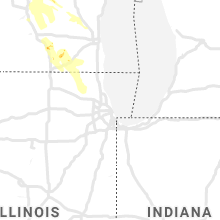
Hail Map for Monday, August 24, 2020

Number of Impacted Households on 8/24/2020
0
Impacted by 1" or Larger Hail
0
Impacted by 1.75" or Larger Hail
0
Impacted by 2.5" or Larger Hail
Square Miles of Populated Area Impacted on 8/24/2020
0
Impacted by 1" or Larger Hail
0
Impacted by 1.75" or Larger Hail
0
Impacted by 2.5" or Larger Hail


Cities Most Affected by Hail Storms of 8/24/2020
| Hail Size | Demographics of Zip Codes Affected | ||||||
|---|---|---|---|---|---|---|---|
| City | Count | Average | Largest | Pop Density | House Value | Income | Age |
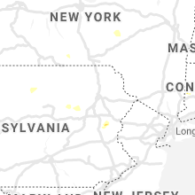
| Middletown, CT | 1 | 1.75 | 1.75 | 1076 | $140k | $47.2k | 37.0 |
Hail and Wind Damage Spotted on 8/24/2020
Filter by Report Type:Hail ReportsWind Reports
States Impacted
Florida, Georgia, Wisconsin, Maine, Virginia, South Carolina, Connecticut, Massachusetts, Pennsylvania, Vermont, Michigan, New Hampshire, New York, Ohio, IllinoisFlorida
| Local Time | Report Details |
|---|---|
| 10:45 AM EDT | A severe thunderstorm wind gust of 65mph / 56 knots was recorded by the wxflow mesonet site xtky turkey poin in miami-dade county FL, 21.7 miles SSW of Miami, FL |
| 1:27 PM EDT | Mesonet station xtrp tarpon p in lee county FL, 30.4 miles NNW of Naples, FL |
| 2:10 PM EDT | Earth networks site mmmch at nicklaus children hospital recorded a 60 mph wind gust associated with a quick-moving thunderstor in miami-dade county FL, 3.4 miles WNW of Miami, FL |
| 5:26 PM EDT | County emergency management reported trees and powerlines down throughout the areas of inverness... henrnando... and beverly hills. time estimate in citrus county FL, 67.5 miles WNW of Orlando, FL |
| 6:15 PM EDT | Trees reported down near county road 152 between jennings and jaspe in hamilton county FL, 67 miles S of Douglas, GA |
| 6:17 PM EDT | A tree was reported down northwest part of live oa in suwannee county FL, 77.1 miles E of Tallahassee, FL |
| 6:50 PM EDT | Power outages due to fallen trees and limb in madison county FL, 52.6 miles E of Tallahassee, FL |
| 6:55 PM EDT | Power outages due to fallen trees and limb in madison county FL, 55.6 miles E of Tallahassee, FL |
| 7:15 PM EDT | Trees reported down near county road 152 between jennings and jasper. time of event based on rada in hamilton county FL, 67 miles S of Douglas, GA |
Georgia
| Local Time | Report Details |
|---|---|
| 12:03 PM EDT | Report of wind damage with photos showing portions of a buildings siding and roofing lifted up and onto the street in downtown baxle in appling county GA, 34.3 miles ENE of Douglas, GA |
| 7:15 PM EDT | Tree down on power line reported via social medi in lowndes county GA, 52.8 miles SSW of Douglas, GA |
| 7:25 PM EDT | Tree down blocking part of troupeville roa in brooks county GA, 52 miles ENE of Tallahassee, FL |
| 7:34 PM EDT | Several trees down in the northern end of lowndes county via the ema lowndes facebook pag in lowndes county GA, 47 miles SW of Douglas, GA |
Wisconsin
| Local Time | Report Details |
|---|---|
| 11:59 AM CDT | Relayed from social media. time estimated from rada in dane county WI, 12 miles NE of Madison, WI |
| 9:17 PM CDT | Quarter sized hail reported near Nekoosa, WI, 77.5 miles ENE of La Crosse, WI, report from mping. time estimated by radar. |
| 11:06 PM CDT | Corrects previous tstm wnd dmg report from 2 sw doylestown. corrects previous non-tstm wnd dmg report from 2 sw doylestown. columbia co. dispatch has reports of multipl in columbia county WI, 25.5 miles NNE of Madison, WI |
| 11:15 PM CDT | Quarter sized hail reported near Augusta, WI, 59.2 miles N of La Crosse, WI, picture via facebook. |
| 11:20 PM CDT | Relayed from social medi in dane county WI, 12.5 miles N of Madison, WI |
| 11:43 PM CDT | Ping Pong Ball sized hail reported near Westfield, WI, 56.6 miles N of Madison, WI, ping pong ball size hail reported. time estimated from radar. |
| 11:50 PM CDT | Quarter sized hail reported near Eau Claire, WI, 66.8 miles N of La Crosse, WI |
| 11:51 PM CDT | Dane co. dispatch has a report of a tree down in windsor. time estimated from rada in dane county WI, 10.4 miles NNE of Madison, WI |
| 11:53 PM CDT | Quarter sized hail reported near Eau Claire, WI, 68.5 miles N of La Crosse, WI, picture on twitter. |
| 12:20 AM CDT | Quarter sized hail reported near Packwaukee, WI, 48.2 miles N of Madison, WI, report of 1 inch hail in packwaukee. |
| 12:25 AM CDT | Half Dollar sized hail reported near Nekoosa, WI, 75.6 miles ENE of La Crosse, WI |
| 12:45 AM CDT | Report of a large tree down on a house in edgerton. time estimated from rada in rock county WI, 22.7 miles SE of Madison, WI |
| 2:45 AM CDT | Several trees down in the are in walworth county WI, 41.9 miles ESE of Madison, WI |
| 2:50 AM CDT | Quarter sized hail reported near Elkhorn, WI, 50.8 miles ESE of Madison, WI, reported at elkhorn - about 5 to 10 minutes of quarter sized hail. |
| 2:55 AM CDT | Report of a tree down in the street and estimated winds estimated to 55 mp in walworth county WI, 36.5 miles ESE of Madison, WI |
| 2:57 AM CDT | Quarter sized hail reported near Stratford, WI, 69.5 miles SSW of Rhinelander, WI, relayed by law enforcement. |
Maine
| Local Time | Report Details |
|---|---|
| 1:27 PM EDT | Trees dow in somerset county ME, 54.6 miles W of Bangor, ME |
| 2:00 PM EDT | Quarter sized hail reported near Jay, ME, 58.1 miles N of Portland, ME |
| 2:08 PM EDT | Tree down on wires across rt. 17 with smoke. time estimated by rada in kennebec county ME, 55.7 miles N of Portland, ME |
| 2:12 PM EDT | Ping Pong Ball sized hail reported near Livermore Falls, ME, 56.9 miles N of Portland, ME, hail nearly to walnut size. estimated winds 60 mph. at least some crop damage. still assessing. |
| 2:12 PM EDT | Trees and wires dow in somerset county ME, 50.5 miles W of Bangor, ME |
| 2:20 PM EDT | Quarter sized hail reported near Kents Hill, ME, 56.2 miles N of Portland, ME |
| 4:00 PM EDT | Quarter sized hail reported near Whitefield, ME, 50.3 miles NE of Portland, ME |
| 4:00 PM EDT | Tree down across the road. reported at peak mountain road sebago me. time estimated by rada in cumberland county ME, 27 miles NW of Portland, ME |
| 4:06 PM EDT | Swath of trees down near peaked mountain road. likely microburst which was seen on wgme tower cam vide in cumberland county ME, 27 miles NW of Portland, ME |
| 4:45 PM EDT | Quarter sized hail reported near Poland, ME, 26.5 miles NNW of Portland, ME |
| 4:55 PM EDT | Trees on wire in cumberland county ME, 12.9 miles NW of Portland, ME |
| 5:17 PM EDT | Quarter sized hail reported near Falmouth, ME, 7.8 miles NW of Portland, ME |
| 5:23 PM EDT | Quarter sized hail reported near Falmouth, ME, 5.8 miles NNW of Portland, ME, mostly penny size hail... but a few quarter size stones fell. |
Virginia
| Local Time | Report Details |
|---|---|
| 1:43 PM EDT | Road closed near the intersection of old keene mill road and hillside road due to downed powerline in fairfax county VA, 48.9 miles SW of Baltimore, MD |
| 1:45 PM EDT | Tree down near the intersection of paul spring road and rebecca drive. time estimated from rada in fairfax county VA, 44.2 miles SW of Baltimore, MD |
| 4:53 PM EDT | Numerous reports of trees and powerlines down in the vicinity of the city of fredericksburg in city of fredericks county VA, 55.6 miles N of Richmond, VA |
| 4:55 PM EDT | Tree down on the 900 block of dahlgren road in king george county VA, 58.8 miles NNE of Richmond, VA |
| 5:01 PM EDT | Tree down near the intersection of tignor lane and anderson street in spotsylvania county VA, 53.6 miles N of Richmond, VA |
| 5:06 PM EDT | Tree down on the 300 block of landsdowne road in city of fredericks county VA, 53.9 miles N of Richmond, VA |
| 5:06 PM EDT | Trees and powerlines down on the 3500 block of mine road in spotsylvania county VA, 52.5 miles NNE of Richmond, VA |
| 5:52 PM EDT | Trees down blocking a portion of jefferson davis highway in massaponax in spotsylvania county VA, 50.8 miles N of Richmond, VA |
| 6:40 PM EDT | Tree down on power line resulting in multiple power outages. time estimated from radar dat in westmoreland county VA, 61.2 miles NE of Richmond, VA |
| 6:58 PM EDT | Trees down blocking smith station rd at jefferson davis highway in spotsylvania county VA, 50 miles N of Richmond, VA |
| 6:59 PM EDT | 9 houses damaged with 1 roof collapsed in the lees park neighborhood. specifically... the 5000 block of holley oak lane. 1 unfinished structure had associated debris im in spotsylvania county VA, 49.2 miles N of Richmond, VA |
| 7:30 PM EDT | Downed trees on sweeney circl in bedford county VA, 38 miles E of Roanoke, VA |
| 7:31 PM EDT | Power lines dow in campbell county VA, 37.9 miles E of Roanoke, VA |
| 7:33 PM EDT | Power lines downed at intersection of enterprise drive and laxton roa in campbell county VA, 39 miles E of Roanoke, VA |
| 7:33 PM EDT | Trees and power lines dow in campbell county VA, 38.4 miles E of Roanoke, VA |
| 7:38 PM EDT | A tree down on power-line along the 1155 block of rainbow forest driv in campbell county VA, 38.4 miles E of Roanoke, VA |
| 7:41 PM EDT | Power-lines reported down along the 120 block of ventura driv in campbell county VA, 38.9 miles E of Roanoke, VA |
| 7:45 PM EDT | Multiple large trees down all along sweeney circle due to strong winds associated with a thunderstorm. storm debris scattered along roadways e.g leaves... twigs... bran in bedford county VA, 38 miles E of Roanoke, VA |
| 7:46 PM EDT | Power-lines down along the 172 block of mount sterling driv in campbell county VA, 40.4 miles E of Roanoke, VA |
South Carolina
| Local Time | Report Details |
|---|---|
| 1:45 PM EDT | Tree down at hwy 321 and hwy 278 as per sc highway patrol. time estimated by rada in allendale county SC, 55.6 miles SE of Augusta, GA |
| 4:55 PM EDT | Tree down on hwy 402 at hwy 52. relayed from the medi in berkeley county SC, 3 miles ENE of Charleston, SC |
| 5:25 PM EDT | Tree down on hwy 17 near hwy 6 in colleton county SC, 39.2 miles SW of Charleston, SC |
Connecticut
| Local Time | Report Details |
|---|---|
| 1:47 PM EDT | Quarter sized hail reported near East Hampton, CT, 58.9 miles WSW of Providence, RI, nickel to quarter sized hail reported. |
| 3:08 PM EDT | Quarter sized hail reported near Middletown, CT, 65.6 miles WSW of Providence, RI |
| 3:08 PM EDT | Golf Ball sized hail reported near Middletown, CT, 65.6 miles WSW of Providence, RI, half dollar to golf ball sized hail reported. |
Massachusetts
| Local Time | Report Details |
|---|---|
| 2:00 PM EDT | Large tree falling on wires on oak stree in bristol county MA, 7.3 miles E of Providence, RI |
| 2:35 PM EDT | Utility pole snapped with a tree down on the wires on tremont s in bristol county MA, 7.3 miles E of Providence, RI |
| 2:50 PM EDT | Tree down on main st. (route 63 in franklin county MA, 76.7 miles E of Schenectady, NY |
| 3:05 PM EDT | Multiple trees down on west roa in franklin county MA, 76.7 miles E of Schenectady, NY |
| 3:10 PM EDT | Tree down on river roa in franklin county MA, 76.7 miles E of Schenectady, NY |
Pennsylvania
| Local Time | Report Details |
|---|---|
| 2:30 PM EDT | Tree down on 18500 block of highway 8 in lycoming county PA, 56.6 miles W of Scranton, PA |
| 4:03 PM EDT | Trees across road in luzerne county PA, 33.6 miles WSW of Scranton, PA |
| 4:10 PM EDT | Wires down and pulled from house in luzerne county PA, 25.8 miles SW of Scranton, PA |
| 4:13 PM EDT | Multiple trees blocking road in luzerne county PA, 15.8 miles SW of Scranton, PA |
| 4:13 PM EDT | Wires down... numerous poles knocked down... numerous trees dow in luzerne county PA, 17.1 miles SW of Scranton, PA |
| 4:50 PM EDT | Trees and wires down on stoney ridge rd. time estimated from rada in carbon county PA, 41 miles S of Scranton, PA |
| 4:55 PM EDT | At least one fire department call for a downed tree in eldred twp. time estimated from rada in monroe county PA, 40 miles SSE of Scranton, PA |
| 5:35 PM EDT | Two large trees down near the intersection of s oaks rd and e walker rd. time estimated from rada in northampton county PA, 45 miles SSE of Scranton, PA |
Vermont
| Local Time | Report Details |
|---|---|
| 2:40 PM EDT | Several trees down on donaldson r in grand isle county VT, 15.4 miles NNW of Burlington, VT |
| 3:24 PM EDT | Trees down at 17/jerusalem road in addison county VT, 23.8 miles SSE of Burlington, VT |
| 3:24 PM EDT | Quarter sized hail reported near Bristol, VT, 24.1 miles SSE of Burlington, VT, cracked car windshield |
| 5:11 PM EDT | Multiple trees down along state route 30 and blissville r in rutland county VT, 61.9 miles S of Burlington, VT |
Michigan
| Local Time | Report Details |
|---|---|
| 2:47 PM EDT | Storm damage reported in washtenaw county MI, 53.3 miles S of Flint, MI |
New Hampshire
| Local Time | Report Details |
|---|---|
| 2:50 PM EDT | Trees down at burt hill r in cheshire county NH, 78.5 miles E of Schenectady, NY |
| 3:40 PM EDT | Trees dow in hillsborough county NH, 79.5 miles WSW of Portland, ME |
| 4:00 PM EDT | Trees dow in hillsborough county NH, 67.5 miles N of Providence, RI |
| 4:00 PM EDT | Quarter sized hail reported near Hudson, NH, 67.4 miles N of Providence, RI |
| 4:04 PM EDT | Half Dollar sized hail reported near Auburn, NH, 72.8 miles SW of Portland, ME |
| 4:10 PM EDT | Half Dollar sized hail reported near Derry, NH, 73.1 miles N of Providence, RI |
| 4:18 PM EDT | Quarter sized hail reported near Derry, NH, 72.3 miles N of Providence, RI |
New York
| Local Time | Report Details |
|---|---|
| 3:00 PM EDT | Trees and wires down on day hollow road. time estimated from rada in tioga county NY, 55 miles NNW of Scranton, PA |
| 3:00 PM EDT | Trees and wires down on marshland road. time estimated from rada in tioga county NY, 54.7 miles NNW of Scranton, PA |
| 3:22 PM EDT | Wires down near 201 stage roa in broome county NY, 51.1 miles NNW of Scranton, PA |
| 5:00 PM EDT | Trees downed on skenesborough drive in front off skenesborough ems building in washington county NY, 57.8 miles NNE of Schenectady, NY |
| 5:03 PM EDT | Numerous snapped and downed trees near skenesborough drive in whitehall. house nearby has roof damag in washington county NY, 57.8 miles NNE of Schenectady, NY |
| 8:50 PM EDT | Trees down along river road to the albany city lin in albany county NY, 16.5 miles SSE of Schenectady, NY |
| 2:41 AM EDT | Tree down on ridge rd blocking road in orleans county NY, 43 miles NE of Buffalo, NY |
Ohio
| Local Time | Report Details |
|---|---|
| 5:05 PM EDT | Large tree limb and power pole downed across roadway. time estimated from rada in huron county OH, 44.1 miles WSW of Cleveland, OH |
Illinois
| Local Time | Report Details |
|---|---|
| 3:36 AM CDT | A couple downed large trees between woodstock and bull valley. distance estimated based on social media report. time estimated using rada in mchenry county IL, 49.6 miles NW of Chicago, IL |
Connect with Interactive Hail Maps