

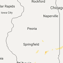
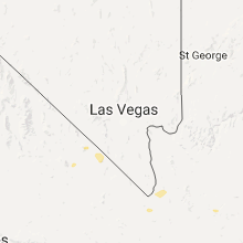
Hail Map for Friday, August 26, 2016

Number of Impacted Households on 8/26/2016
0
Impacted by 1" or Larger Hail
0
Impacted by 1.75" or Larger Hail
0
Impacted by 2.5" or Larger Hail
Square Miles of Populated Area Impacted on 8/26/2016
0
Impacted by 1" or Larger Hail
0
Impacted by 1.75" or Larger Hail
0
Impacted by 2.5" or Larger Hail


Cities Most Affected by Hail Storms of 8/26/2016
| Hail Size | Demographics of Zip Codes Affected | ||||||
|---|---|---|---|---|---|---|---|
| City | Count | Average | Largest | Pop Density | House Value | Income | Age |
| Piedmont, OK | 2 | 1.75 | 1.75 | 123 | $108k | $53.8k | 36.5 |
| Herndon, KS | 1 | 1.75 | 1.75 | 1 | $22k | $25.2k | 53.3 |
| Yoder, WY | 1 | 1.75 | 1.75 | 1 | $66k | $30.4k | 49.6 |
Hail and Wind Damage Spotted on 8/26/2016
Filter by Report Type:Hail ReportsWind Reports
States Impacted
Indiana, Alabama, Illinois, Missouri, Wyoming, Tennessee, South Dakota, Ohio, Nevada, Oklahoma, Kansas, California, ArizonaIndiana
| Local Time | Report Details |
|---|---|
| 8:30 AM EDT | Multiple trees dow in marion county IN, 7.8 miles NNE of Indianapolis, IN |
| 8:30 AM EDT | Tree blew down into a home near 57th and meridian. corrected locatio in marion county IN, 0.9 miles N of Indianapolis, IN |
| 8:30 AM EDT | Tree blew down into a home near 57th and meridian. corrected locatio in marion county IN, 0.9 miles N of Indianapolis, IN |
| 8:35 AM EDT | Quarter sized hail reported near Carmel, IN, 14.2 miles N of Indianapolis, IN, multiple trees and power lines down along shelbourne rd. large hail reported as well. time estimated. |
| 8:35 AM EDT | Multiple trees and power lines down along shelbourne rd. large hail reported as well. time estimate in hamilton county IN, 14.2 miles N of Indianapolis, IN |
| 8:45 AM EDT | Hail reported near 32nd and shadeland in marion county IN, 0.9 miles N of Indianapolis, IN |
| 8:50 AM EDT | Multiple trees damaged... large tree limbs down and at least one tree snappe in marion county IN, 6.6 miles NNE of Indianapolis, IN |
Alabama
| Local Time | Report Details |
|---|---|
| 2:40 PM CDT | Lawrence county ema reports power lines down on court st in moulto in lawrence county AL, 31.1 miles SE of Florence, AL |
| 2:40 PM CDT | Lawrence county ema reported a couple trees down in the oakville district near speak in lawrence county AL, 38 miles SE of Florence, AL |
| 3:04 PM CDT | Ema reports trees down near the lagrange community in colbert county AL, 14.2 miles SSE of Florence, AL |
| 3:04 PM CDT | Trees reported down near the lagrange community in colbert county AL, 13.8 miles SSE of Florence, AL |
| 3:29 PM CDT | Ema reports tree down on power lines near leighton in colbert county AL, 8.6 miles SE of Florence, AL |
| 3:40 PM CDT | Building collapse at a lumber yard near littleville in colbert county AL, 14.5 miles S of Florence, AL |
| 3:40 PM CDT | Colbert county ema reports trees down in littleville. time estimated by radar in colbert county AL, 10.4 miles S of Florence, AL |
| 3:50 PM CDT | Ema reported a power pole down near sheffield in colbert county AL, 2.8 miles S of Florence, AL |
| 3:58 PM CDT | Ema reports a couple trees down near cherokee in colbert county AL, 12.9 miles W of Florence, AL |
| 5:26 PM CDT | Tree down on a house. time estimated from rada in madison county AL, 70.2 miles WSW of Chattanooga, TN |
| 5:30 PM CDT | Tree down on power lines on madison ave. time estimated from rada in madison county AL, 71.7 miles WSW of Chattanooga, TN |
| 5:35 PM CDT | Tree down across one lane of brownsboro rd. time estimated from rada in madison county AL, 67.9 miles WSW of Chattanooga, TN |
| 5:58 PM CDT | Tree down and power lines down on white st. time estimated from rada in madison county AL, 62.5 miles E of Florence, AL |
| 6:05 PM CDT | Tree down and power lines down on biscayne st. time estimated from rada in madison county AL, 60.4 miles E of Florence, AL |
| 6:05 PM CDT | Power lines and poles downed. time estimated from rada in madison county AL, 60.2 miles E of Florence, AL |
| 6:05 PM CDT | Tree down at the corner of blue spring rd and mastin lake rd. time estimated from rada in madison county AL, 61.2 miles E of Florence, AL |
| 6:05 PM CDT | Large tree limb down at the corner of greenacres dr. and holmes ave. limb is down on power lines and partly blocking greenacres dr. time estimated from rada in madison county AL, 59.7 miles E of Florence, AL |
Illinois
| Local Time | Report Details |
|---|---|
| 2:45 PM CDT | Multiple tree branches and limbs downed. some limbs with 2-3 inch diameters. time estimated by rada in edgar county IL, 38.2 miles ENE of Mattoon, IL |
| 2:48 PM CDT | Quarter sized hail reported near Paris, IL, 40.5 miles ENE of Mattoon, IL |
| 2:50 PM CDT | Tree limbs blown onto 6 houses. 9 locations with power lines down. most damage on the east side of town. time estimate in edgar county IL, 38.9 miles ENE of Mattoon, IL |
| 3:54 PM CDT | Quarter sized hail reported near Sullivan, IL, 9.4 miles WNW of Mattoon, IL |
| 4:50 PM CDT | Tree blown onto power lines on harrison s in coles county IL, 10.5 miles E of Mattoon, IL |
| 6:10 PM CDT | Tree down on route 10 and west street. tree down on lynn stree in de witt county IL, 48.3 miles NNW of Mattoon, IL |
Missouri
| Local Time | Report Details |
|---|---|
| 4:22 PM CDT | Severe thunderstorm wind gusts caused power line damage northeast of houston. 15 customers lost powe in texas county MO, 29.3 miles SW of Salem, MO |
| 6:56 PM CDT | Storm damage reported in clinton county MO, 24.6 miles N of Kansas City, MO |
| 7:15 PM CDT | Storm damage reported in clinton county MO, 32.2 miles NNE of Kansas City, MO |
| 7:41 PM CDT | Inflow winds at i35 and route 11 in clinton county MO, 35.1 miles NNE of Kansas City, MO |
| 8:12 PM CDT | Eight to ten inch diameter tree across the roa in clinton county MO, 33.7 miles NNE of Kansas City, MO |
Wyoming
| Local Time | Report Details |
|---|---|
| 3:39 PM MDT | Golf Ball sized hail reported near Yoder, WY, 31.7 miles W of Scottsbluff, NE |
Tennessee
| Local Time | Report Details |
|---|---|
| 4:57 PM CDT | One tree down in the two hundred block of bear creek roa in wayne county TN, 24.5 miles N of Florence, AL |
| 5:00 PM CDT | One large tree down. reportand picture relayed by nws nashvill in hardin county TN, 38.7 miles NNW of Florence, AL |
| 5:42 PM CDT | One tree dow in maury county TN, 48.5 miles SSW of Nashville, TN |
| 5:45 PM CDT | One tree down at a residence in hampshire in maury county TN, 47.8 miles SW of Nashville, TN |
| 5:48 PM CDT | One tree dow in maury county TN, 40.7 miles SSW of Nashville, TN |
| 6:24 PM CDT | One tree reported down on highway 412 eas in perry county TN, 50.9 miles SE of Mc Kenzie, TN |
| 6:24 PM CDT | Report of a tree down on highway 48 sout in hickman county TN, 53.5 miles SW of Nashville, TN |
| 6:24 PM CDT | Report of a tree down on highway 100 wes in hickman county TN, 56 miles SE of Mc Kenzie, TN |
| 6:56 PM CDT | Uncomfirmed report of a possible microburst. pictures of trees down on kedron road across from the kings creek golf course. reports of 50-60 pound plantern urns being m in maury county TN, 32.4 miles SSW of Nashville, TN |
| 7:30 PM CDT | Several trees down and damage to outbuildings at the flea market near ethridg in lawrence county TN, 43.1 miles NNE of Florence, AL |
| 8:12 PM CDT | Report of a tree down in the hampshire pike are in maury county TN, 43.5 miles SSW of Nashville, TN |
| 8:12 PM CDT | Report of a tree down in the willaimsport pike are in maury county TN, 41.7 miles SSW of Nashville, TN |
| 8:24 PM CDT | A couple of trees reported down in the santa fe are in maury county TN, 36.1 miles SSW of Nashville, TN |
South Dakota
| Local Time | Report Details |
|---|---|
| 4:10 PM MDT | Quarter sized hail reported near Spearfish, SD, 49.5 miles NW of Rapid City, SD |
| 4:14 PM MDT | Quarter sized hail reported near Spearfish, SD, 46.3 miles NW of Rapid City, SD |
| 4:25 PM MDT | Storm damage reported in lawrence county SD, 40.1 miles NW of Rapid City, SD |
| 7:48 PM MDT | Half Dollar sized hail reported near Hermosa, SD, 28.6 miles SE of Rapid City, SD, damage to leaves and flowers. |
Ohio
| Local Time | Report Details |
|---|---|
| 7:20 PM EDT | A few trees downed in ross townshi in butler county OH, 18.3 miles NNW of Cincinnati, OH |
| 8:30 PM EDT | A few trees down in germantow in montgomery county OH, 36.8 miles N of Cincinnati, OH |
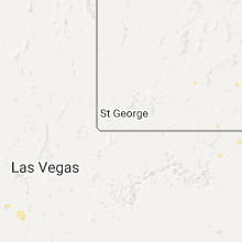
Nevada
| Local Time | Report Details |
|---|---|
| 4:47 PM PDT | Mesonet station currant creek raws /ccrn2 in nye county NV, 43.4 miles SW of Ely, NV |
Oklahoma
| Local Time | Report Details |
|---|---|
| 7:40 PM CDT | Ping Pong Ball sized hail reported near Piedmont, OK, 17.4 miles NW of Oklahoma City, OK, reported by piedmont pd |
| 7:43 PM CDT | Golf Ball sized hail reported near Piedmont, OK, 17 miles NW of Oklahoma City, OK |
| 7:49 PM CDT | Golf Ball sized hail reported near Piedmont, OK, 15.8 miles NW of Oklahoma City, OK |
Kansas
| Local Time | Report Details |
|---|---|
| 7:54 PM CDT | Golf Ball sized hail reported near Herndon, KS, 37.9 miles NNE of Colby, KS, windows broken from wind driven hail. |
California
| Local Time | Report Details |
|---|---|
| 9:44 PM PDT | Asos station needles airport /eed in san bernardino county CA, 25.7 miles NW of Lake Havasu City, AZ |
Arizona
| Local Time | Report Details |
|---|---|
| 10:35 PM MST | Awos station bullhead city airport /ifp in mohave county AZ, 44.7 miles N of Lake Havasu City, AZ |
Connect with Interactive Hail Maps