

Hail Map for Tuesday, August 27, 2019

Number of Impacted Households on 8/27/2019
0
Impacted by 1" or Larger Hail
0
Impacted by 1.75" or Larger Hail
0
Impacted by 2.5" or Larger Hail
Square Miles of Populated Area Impacted on 8/27/2019
0
Impacted by 1" or Larger Hail
0
Impacted by 1.75" or Larger Hail
0
Impacted by 2.5" or Larger Hail


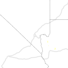


Cities Most Affected by Hail Storms of 8/27/2019
| Hail Size | Demographics of Zip Codes Affected | ||||||
|---|---|---|---|---|---|---|---|
| City | Count | Average | Largest | Pop Density | House Value | Income | Age |
| El Paso, TX | 3 | 1.75 | 1.75 | 1347 | $74k | $34.8k | 33.1 |
Hail and Wind Damage Spotted on 8/27/2019
Filter by Report Type:Hail ReportsWind Reports
Texas
| Local Time | Report Details |
|---|---|
| 1:54 PM CDT | Quarter sized hail reported near Shamrock, TX, 60.6 miles NNW of Childress, TX |
| 5:35 PM MDT | Quarter sized hail reported near Fort Hancock, TX, 48.7 miles SE of El Paso, TX |
| 7:25 PM CDT | Quarter sized hail reported near Monahans, TX, 37.1 miles WSW of Odessa, TX |
| 7:10 PM MDT | Quarter sized hail reported near El Paso, TX, 9.6 miles NNW of El Paso, TX, cocorahs observer reported 1.0 inch hail with car damage. |
| 7:10 PM MDT | Golf Ball sized hail reported near El Paso, TX, 5.7 miles NNW of El Paso, TX |
| 7:23 PM MDT | Golf Ball sized hail reported near El Paso, TX, 12.6 miles N of El Paso, TX, hail falling at southwest university park. |
| 7:23 PM MDT | Golf Ball sized hail reported near El Paso, TX, 0.2 miles WNW of El Paso, TX, hail falling at southwest university park. |
| 8:30 PM CDT | Powerlines down in barsto in ward county TX, 65.6 miles WSW of Odessa, TX |
| 8:35 PM CDT | Power lines are down at 3rd street and peach stree in reeves county TX, 72.9 miles WSW of Odessa, TX |
| 8:40 PM CDT | Quarter sized hail reported near Barstow, TX, 65.6 miles WSW of Odessa, TX |
| 8:50 PM CDT | Storm damage reported in reeves county TX, 71.6 miles N of Alpine, TX |
Michigan
| Local Time | Report Details |
|---|---|
| 3:00 PM EDT | Power lines down in ishpeming off west superior street. delayed repor in marquette county MI, 12.4 miles WSW of Marquette, MI |
| 3:05 PM EDT | Trees on power lines along cooper lake road in ishpeming twp. delayed repor in marquette county MI, 14.3 miles W of Marquette, MI |
| 3:05 PM EDT | Several trees downed along deer lake road...south of south camp road in ishpeming tw in marquette county MI, 13.2 miles W of Marquette, MI |
| 3:05 PM EDT | Wluctv6 reports a large diameter maple tree was snapped along east peck street in the city of negaunee. delayed repor in marquette county MI, 9.9 miles WSW of Marquette, MI |
| 3:05 PM EDT | Trees down on power lines south of the dead river basin along deer lake road. delayed repor in marquette county MI, 14.9 miles WNW of Marquette, MI |
| 3:13 PM EDT | Nws employee observed large 18 inch diameter hardwood tree snapped on m-35 just to the south of the nws forecast office in negaunee twp. delayed repor in marquette county MI, 6.1 miles W of Marquette, MI |
| 3:15 PM EDT | Large white pine tree broke along heritage drive in negaunee twp. delayed repor in marquette county MI, 8.1 miles WSW of Marquette, MI |
| 3:25 PM EDT | Downed power lines near the berry events center on the campus of northern michigan university. delayed repor in marquette county MI, 1.5 miles NE of Marquette, MI |
| 3:25 PM EDT | Trees on power lines with smoke observed along wright street in marquette twp. delayed repor in marquette county MI, 2 miles WNW of Marquette, MI |
| 3:25 PM EDT | Downed power lines in the city of marquette near the intersection of south mcclellan and west washington street. delayed repor in marquette county MI, 0.4 miles NW of Marquette, MI |
| 3:25 PM EDT | Trees blocking half of marquette county road 492 near grove street. delayed repor in marquette county MI, 2 miles WSW of Marquette, MI |
| 3:25 PM EDT | Power line downed along the intersection of east hewitt and high streets in the city of marquette. delayed repor in marquette county MI, 1.2 miles ENE of Marquette, MI |
| 3:25 PM EDT | Downed trees on power lines along east michigan street in the city of marquette. delayed repor in marquette county MI, 1.6 miles E of Marquette, MI |
| 3:25 PM EDT | Tree on power line along marquette county road 510 just to the south of the dead river in the city of marquette. delayed repor in marquette county MI, 1.7 miles N of Marquette, MI |
| 3:25 PM EDT | Photo received via social media of a tree uprooted. delayed report. time estimated by rada in marquette county MI, 1.8 miles NNE of Marquette, MI |
| 3:26 PM EDT | Corrects previous tstm wnd dmg report from 5 nnw ishpeming. multiple trees reported down via dispatch scanner. county road commission may be assisting with response. ti in marquette county MI, 13.2 miles W of Marquette, MI |
| 3:30 PM EDT | Trees reported down via police scanner in marquette county MI, 4.5 miles WSW of Marquette, MI |
| 3:33 PM EDT | Estimated 60mph wind gust in marquett in marquette county MI, 2 miles WNW of Marquette, MI |
| 3:35 PM EDT | Multiple trees reported down via dispatch scanner. county road commission may be assisting with respons in marquette county MI, 13.2 miles W of Marquette, MI |
| 3:38 PM EDT | Trees reported blocking the road. report from police scanne in marquette county MI, 1.8 miles WSW of Marquette, MI |
| 3:39 PM EDT | Large diameter jackpine tree greater than 12 inch diameter took down power lines on east ski hill road in little lake. large aspen tree also downed the vicinity. delaye in marquette county MI, 18.2 miles SSE of Marquette, MI |
| 3:45 PM EDT | Delayed report. received pictures of an approximately 12 inch diameter tree down in gwin in marquette county MI, 18.4 miles S of Marquette, MI |
| 5:50 PM EDT | 60 knot wind gust measured on commercial vessel... along with waterspouts observe in lsz321 county MI, 32 miles NW of Sault Sainte Marie, MI |
| 5:58 PM EDT | Relayed via apx and the sault ste. marie coast guard. waterspouts also sighte in lsz251 county MI, 37.1 miles NW of Sault Sainte Marie, MI |
| 7:10 PM EDT | Trees down at lakeshore drive near wilcox lane. relayed by media. time estimated from rada in chippewa county MI, 15.7 miles W of Sault Sainte Marie, MI |
| 9:00 PM EDT | Corrects previous tstm wnd gst report from 28 ese keweenaw point. mesonet station stdm4 27 ese keweenaw point. time is approximat in lsz266 county MI, 44.8 miles NNE of Marquette, MI |
Alabama
| Local Time | Report Details |
|---|---|
| 4:40 PM CDT | Trees were blown down on johnson drive and thed brassfield roa in jefferson county AL, 18.4 miles NW of Birmingham, AL |
| 4:42 PM CDT | A few trees were blown down near highway 78 and jasper roa in jefferson county AL, 18.4 miles NW of Birmingham, AL |
| 4:50 PM CDT | Numerous trees and power lines were blown down on empire road... on hill road... and on drummond cut-off roa in walker county AL, 23 miles NNW of Birmingham, AL |
| 5:10 PM CDT | Trees down along flatwoods roa in tuscaloosa county AL, 50.3 miles WSW of Birmingham, AL |
| 5:12 PM CDT | Trees down along union chapel roa in tuscaloosa county AL, 46.8 miles WSW of Birmingham, AL |
| 5:12 PM CDT | Trees and power lines blown down on beaver trai in blount county AL, 24.2 miles N of Birmingham, AL |
| 5:13 PM CDT | A large tree was blown down at meadowlark lane and lee s in blount county AL, 40.4 miles NNE of Birmingham, AL |
| 5:15 PM CDT | A few trees were blown dow in blount county AL, 40.3 miles NNE of Birmingham, AL |
| 5:15 PM CDT | Trees were blown down along highway 7 in blount county AL, 34.8 miles NNE of Birmingham, AL |
| 5:17 PM CDT | A tree was blown down in front of bryant denny stadiu in tuscaloosa county AL, 47.8 miles WSW of Birmingham, AL |
| 5:17 PM CDT | Trees down along kicker roa in tuscaloosa county AL, 46.4 miles WSW of Birmingham, AL |
| 5:20 PM CDT | Trees were blown down in blount county AL, 31.1 miles NNE of Birmingham, AL |
| 5:24 PM CDT | Several trees were blown down in and around oneont in blount county AL, 35.5 miles NNE of Birmingham, AL |
| 5:24 PM CDT | A large tree fell on a vehicle in tuscaloos in tuscaloosa county AL, 48.6 miles WSW of Birmingham, AL |
| 5:36 PM CDT | Several trees were blown down and blocking morton roa in blount county AL, 36.5 miles NE of Birmingham, AL |
| 5:40 PM CDT | Trees down partially blocking exit 86 on i-20/5 in tuscaloosa county AL, 36.3 miles SW of Birmingham, AL |
| 5:42 PM CDT | Numerous trees were blown down all along the blount st clair county lin in blount county AL, 38.4 miles NE of Birmingham, AL |
| 5:45 PM CDT | Numerous trees were blown down across northern st clair count in st. clair county AL, 40.4 miles NE of Birmingham, AL |
| 5:54 PM CDT | Power lines were blown down on highway 411 and a fire was starte in st. clair county AL, 39.1 miles NE of Birmingham, AL |
| 6:24 PM CDT | Trees were blown down and into the roadway along mudd stree in calhoun county AL, 46 miles ENE of Birmingham, AL |
| 7:00 PM CDT | Tree down on easterwood d in calhoun county AL, 58 miles E of Birmingham, AL |
| 7:18 PM CDT | Trees and power lines down on tanglewood d in calhoun county AL, 55.2 miles E of Birmingham, AL |
New Mexico
| Local Time | Report Details |
|---|---|
| 4:35 PM MDT | Quarter sized hail reported near Rio Rancho, NM, 11.1 miles NNW of Albuquerque, NM, golf course and cabazon |
Connect with Interactive Hail Maps