

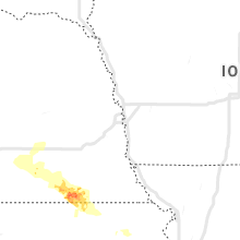
Hail Map for Monday, August 26, 2019

Number of Impacted Households on 8/26/2019
0
Impacted by 1" or Larger Hail
0
Impacted by 1.75" or Larger Hail
0
Impacted by 2.5" or Larger Hail
Square Miles of Populated Area Impacted on 8/26/2019
0
Impacted by 1" or Larger Hail
0
Impacted by 1.75" or Larger Hail
0
Impacted by 2.5" or Larger Hail


Cities Most Affected by Hail Storms of 8/26/2019
| Hail Size | Demographics of Zip Codes Affected | ||||||
|---|---|---|---|---|---|---|---|
| City | Count | Average | Largest | Pop Density | House Value | Income | Age |
| Minco, OK | 1 | 3.00 | 3.00 | 12 | $53k | $32.5k | 40.8 |
| Diller, NE | 1 | 1.75 | 1.75 | 5 | $39k | $37.2k | 44.9 |
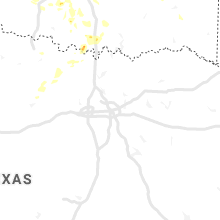
Hail and Wind Damage Spotted on 8/26/2019
Filter by Report Type:Hail ReportsWind Reports
Nebraska
| Local Time | Report Details |
|---|---|
| 7:00 AM CDT | Dime sized hail also fallin in clay county NE, 26.2 miles SSE of Grand Island, NE |
| 7:10 AM CDT | Delayed report from this morning of several tree branches down... some to at least 6 inch diameter. photos posted to social medi in york county NE, 40.8 miles ESE of Grand Island, NE |
| 8:20 AM CDT | Quarter sized hail reported near Fairbury, NE, 69.7 miles NNW of Manhattan, KS |
| 8:28 AM CDT | Ping Pong Ball sized hail reported near Diller, NE, 65.7 miles NNW of Manhattan, KS |
| 8:31 AM CDT | Golf Ball sized hail reported near Diller, NE, 67.3 miles NNW of Manhattan, KS |
| 8:38 AM CDT | Quarter sized hail reported near Diller, NE, 62.7 miles NNW of Manhattan, KS |
Kansas
| Local Time | Report Details |
|---|---|
| 11:07 AM CDT | Partial collapse of large warehouse building in olath in johnson county KS, 23.1 miles SW of Kansas City, MO |
| 11:08 AM CDT | Kixd asos reported a 76 mph wind gus in johnson county KS, 25.2 miles SW of Kansas City, MO |
| 11:10 AM CDT | Storm damage reported in johnson county KS, 20 miles SW of Kansas City, MO |
| 7:48 PM CDT | Quarter sized hail reported near Scammon, KS, 44.9 miles SE of Chanute, KS, just north of columbus; relayed to law enforcement. |
| 8:17 PM CDT | Half Dollar sized hail reported near Columbus, KS, 52.3 miles SE of Chanute, KS, relayed to law enforcement; east of columbus. |
| 8:30 PM CDT | Reported south of columbus; speed estimate in cherokee county KS, 51.7 miles SE of Chanute, KS |
Missouri
| Local Time | Report Details |
|---|---|
| 1:48 PM CDT | 4 to 5 inch branches down e of jerico spring in cedar county MO, 48.6 miles NW of Springfield, MO |
| 1:57 PM CDT | Wind gust estimated at 60 mph at mutten creek recreation area along stockton lak in dade county MO, 35.3 miles NW of Springfield, MO |
| 2:15 PM CDT | Several trees uprooted in west waynesville in old farm estate in pulaski county MO, 38.8 miles WNW of Salem, MO |
| 2:18 PM CDT | Picture of a tree downed onto a driveway east of greenfield. time estimated from rada in dade county MO, 31.6 miles WNW of Springfield, MO |
| 2:20 PM CDT | Downed trees and damage to a roof in st. robert. numerous power outages. time estimated from rada in pulaski county MO, 35.7 miles WNW of Salem, MO |
| 2:25 PM CDT | Large limb down in back yar in pulaski county MO, 46.3 miles WNW of Salem, MO |
| 2:25 PM CDT | Multiple trees down and leaning power lines. the back of an outbuilding was also blown out. damage is laying in the same direction. time estimated from rada in dade county MO, 24.8 miles WNW of Springfield, MO |
| 2:29 PM CDT | 1 inch tree limbs broken; shingles blown of in pulaski county MO, 32.8 miles WNW of Salem, MO |
| 2:30 PM CDT | Trees were down blocking highway 133 between swedeborg and richland in northern pulaski county... m in pulaski county MO, 49.7 miles WNW of Salem, MO |
| 2:34 PM CDT | Tree on residence in rolla on faulkner. no injuries reported. trees also down in area of phelps health hospital in rolla. time based on rada in phelps county MO, 25.1 miles NNW of Salem, MO |
| 2:38 PM CDT | 5 miles north of halltown ne lawrence county wind speed estimated 60 miles per hour. 1 to 2 inch branches dow in lawrence county MO, 19.1 miles WNW of Springfield, MO |
| 2:45 PM CDT | Tree down miller mo around 2:45 p in lawrence county MO, 30.3 miles W of Springfield, MO |
| 2:52 PM CDT | Pictures of multiple trees downed off of high street and elliot ave in northern auror in lawrence county MO, 28.9 miles WSW of Springfield, MO |
| 2:55 PM CDT | Quarter sized hail reported near Billings, MO, 17.2 miles SW of Springfield, MO, also limbs blown down. |
| 2:56 PM CDT | Numerous trees broken... uprooted and snapped in half off of highway 96 near the interstate 44 exit in halltown. time estimated from rada in lawrence county MO, 20.4 miles W of Springfield, MO |
| 3:00 PM CDT | Tree down and roof damag in lawrence county MO, 18.8 miles W of Springfield, MO |
| 3:00 PM CDT | Delayed report of several trees uprooted northwest of billings. time estimated from rada in greene county MO, 17.3 miles WSW of Springfield, MO |
| 3:20 PM CDT | Just lost a limb out of a post oak tree in my front yard. probably 3 to 4 inches in width. rain is sideway in stone county MO, 17.9 miles SSW of Springfield, MO |
| 3:30 PM CDT | Numerous large trees downed and business building damaged. time estimated from rada in stone county MO, 32 miles S of Springfield, MO |
| 3:40 PM CDT | Heavy damage to several metal outbuildings near highway 160. time estimated from rada in christian county MO, 26.3 miles S of Springfield, MO |
| 3:43 PM CDT | Multiple trees and 2 powerlines downed off of reno springs road. time estimated from rada in stone county MO, 27.5 miles S of Springfield, MO |
| 3:45 PM CDT | A power line and multiple trees down on keystone road near highway 160. time estimated from rada in stone county MO, 30.4 miles S of Springfield, MO |
| 3:50 PM CDT | Public report relayed by media partner of a tree into a home near branson off highway 160 and highway 24 in taney county MO, 32.3 miles S of Springfield, MO |
| 4:18 PM CDT | Tree dow in madison county MO, 45.5 miles WNW of Cape Girardeau, MO |
| 5:39 PM CDT | Quarter sized hail reported near Poplar Bluff, MO, 67.9 miles WSW of Cape Girardeau, MO |
| 5:43 PM CDT | Tree down on cr450 and power line down on cr 46 in butler county MO, 68.3 miles SW of Cape Girardeau, MO |
| 5:51 PM CDT | Tree down on a ca in butler county MO, 63.9 miles SW of Cape Girardeau, MO |
| 10:34 PM CDT | Report relayed to em by both law and fire. 60 mph recorded in both noel and lanaga in mcdonald county MO, 76.7 miles WSW of Springfield, MO |
| 11:32 PM CDT | Severe thunderstorm wind gusts downed a tree across highway 5 between mansfield and hartvill in wright county MO, 40.6 miles E of Springfield, MO |
| 11:56 PM CDT | Radio station in cabool measured 72 mph. there are also trees damaged in tow in texas county MO, 47.3 miles SW of Salem, MO |
| 12:51 AM CDT | Severe thunderstorm wind gusts downed trees along highway 101 near the ozark and howell county lin in ozark county MO, 77.1 miles SE of Springfield, MO |
| 1:00 AM CDT | Severe thunderstorm wind gusts caused tree damage in west plain in howell county MO, 64.9 miles SSW of Salem, MO |
Arkansas
| Local Time | Report Details |
|---|---|
| 4:43 PM CDT | Trees were blown down onto power lines on dubuque roa in boone county AR, 61.9 miles S of Springfield, MO |
| 4:47 PM CDT | Trees were blown down onto power line in boone county AR, 64.2 miles S of Springfield, MO |
| 5:01 PM CDT | A tree limb was blown down onto a power line... causing outage in boone county AR, 67.5 miles S of Springfield, MO |
| 5:10 PM CDT | Quarter sized hail reported near Harrison, AR, 67.5 miles S of Springfield, MO |
| 10:54 PM CDT | Several trees down on roads in gravette. fire department is busy trying to remove them. time is estimated from rada in benton county AR, 71.4 miles N of Fort Smith, AR |
| 10:56 PM CDT | A tree fell on top of a carport squishing one car and damaging another. another tree was uprooted and fell on a storage shed. report was relayed by broadcast media with in benton county AR, 71.4 miles N of Fort Smith, AR |
| 11:00 PM CDT | Video on social media shows at least one large tree uprooted along with several bracnhes downed. time estimated from rada in benton county AR, 72.9 miles N of Fort Smith, AR |
| 11:01 PM CDT | Several reports relayed by broadcast media of tree and property damage across centerton and the surrounding area. time is estimated by rada in benton county AR, 67.7 miles N of Fort Smith, AR |
| 11:02 PM CDT | Large tree branches blocking wellington rd. in bella vista... ar from strong wind in benton county AR, 72.9 miles N of Fort Smith, AR |
| 11:04 PM CDT | Asos at xna measured gust to 66mph in benton county AR, 62 miles N of Fort Smith, AR |
| 11:09 PM CDT | 1 inch tree limbs broken and shingles blown off via mping in benton county AR, 68 miles NNE of Fort Smith, AR |
| 11:14 PM CDT | Large tree branch down near nw 13th st. the media also relayed a report of several trees down according to the mayor of bentonville within the city of bentonville. time in benton county AR, 70.1 miles N of Fort Smith, AR |
| 11:16 PM CDT | Tree limbs down in springdale. time is estimated from rada in washington county AR, 56.6 miles NNE of Fort Smith, AR |
| 11:35 PM CDT | Tree down in the middle of the road to the east of s 40th st in springdal in washington county AR, 57.1 miles NNE of Fort Smith, AR |
| 1:12 AM CDT | Trees and power lines down on hwy 395n in northern fulton count in fulton county AR, 80.5 miles S of Salem, MO |
| 1:26 AM CDT | Storm spotter estimates a wind gust to 60mp in sebastian county AR, 15.6 miles SE of Fort Smith, AR |
| 2:21 AM CDT | Storm chaser measured 59 mph wind gust in walnut ridg in lawrence county AR, 81.6 miles NW of Memphis, TN |
South Dakota
| Local Time | Report Details |
|---|---|
| 4:24 PM MDT | Storm damage reported in harding county SD, 106 miles N of Rapid City, SD |
Minnesota
| Local Time | Report Details |
|---|---|
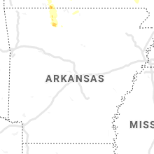
| 6:23 PM CDT | Quarter sized hail reported near Vernon Center, MN, 73.8 miles NW of Mason City, IA, mostly dimes to nickels with a few quarters. |
Oklahoma
| Local Time | Report Details |
|---|---|
| 8:35 PM CDT | Quarter sized hail reported near Pawhuska, OK, 40.7 miles NNW of Tulsa, OK, picture from social media shows quarter size hail. |
| 8:37 PM CDT | Broadcast media estimates a 62mph wind gust 2 miles se of pawhusk in osage county OK, 38.8 miles NNW of Tulsa, OK |
| 8:55 PM CDT | Wind gust measured to 70mph along highway 11 se of pawhusk in osage county OK, 37.9 miles NNW of Tulsa, OK |
| 9:00 PM CDT | Asos report in logan county OK, 28.7 miles NNE of Oklahoma City, OK |
| 9:00 PM CDT | Asos report in oklahoma county OK, 7.8 miles WNW of Oklahoma City, OK |
| 9:00 PM CDT | Asos report- corrected wind speed in logan county OK, 28.7 miles NNE of Oklahoma City, OK |
| 9:20 PM CDT | Asos measurement in canadian county OK, 13.9 miles NW of Oklahoma City, OK |
| 9:43 PM CDT | Asos report in oklahoma county OK, 0.6 miles ESE of Oklahoma City, OK |
| 9:53 PM CDT | Spotter report... estimate in cleveland county OK, 16.4 miles SSE of Oklahoma City, OK |
| 9:55 PM CDT | Ham radio report in cleveland county OK, 14 miles SSE of Oklahoma City, OK |
| 9:59 PM CDT | Trees reported down around independence and 40t in oklahoma county OK, 3.8 miles NW of Oklahoma City, OK |
| 10:00 PM CDT | Mesonet wind report in oklahoma county OK, 3.4 miles E of Oklahoma City, OK |
| 10:04 PM CDT | Asos measurement in oklahoma county OK, 8.2 miles ESE of Oklahoma City, OK |
| 10:05 PM CDT | 70 mph at tinker afb aso in oklahoma county OK, 8.5 miles ESE of Oklahoma City, OK |
| 10:05 PM CDT | Several reports of damage in the area of grove and wyandotte including number 10 bridge near elk river which is closed due to power lines down. time is estimated from r in delaware county OK, 74.7 miles ENE of Tulsa, OK |
| 10:15 PM CDT | Measured 58mph wind gust at pryor mesonet sit in mayes county OK, 39.2 miles ENE of Tulsa, OK |
| 10:16 PM CDT | Asos measurement in oklahoma county OK, 8.2 miles ESE of Oklahoma City, OK |
| 10:18 PM CDT | Half Dollar sized hail reported near Norman, OK, 15.7 miles SSE of Oklahoma City, OK, spotternetwork report |
| 10:18 PM CDT | Half Dollar sized hail reported near Oklahoma City, OK, 8.7 miles WSW of Oklahoma City, OK, spotternetwork report - corrected location |
| 10:19 PM CDT | Spotter reports trees dow in cleveland county OK, 17.5 miles SSE of Oklahoma City, OK |
| 10:20 PM CDT | Multiple trees down at lindsay and candlewood road in cleveland county OK, 19.1 miles SSE of Oklahoma City, OK |
| 10:20 PM CDT | Mesonet measurement in pottawatomie county OK, 35.1 miles ESE of Oklahoma City, OK |
| 10:21 PM CDT | 3 power poles down across highway 28 between 426/427 in mayes county OK, 38.7 miles ENE of Tulsa, OK |
| 10:21 PM CDT | Ping Pong Ball sized hail reported near Oklahoma City, OK, 7.2 miles SSW of Oklahoma City, OK, spotter call... 1.5 inch hail at 89th and portland |
| 10:23 PM CDT | Multiple trees down north and west of adai in mayes county OK, 44.9 miles ENE of Tulsa, OK |
| 10:25 PM CDT | Multiple power lines reported around norman - 900 barkley... 3000 ne 96th... 1000 montgomery... 600 e. vicksburg... 1800 yorktown... 500 sinclair. grass fires also repo in cleveland county OK, 19.1 miles SSE of Oklahoma City, OK |
| 10:28 PM CDT | Asos report in oklahoma county OK, 6.7 miles SW of Oklahoma City, OK |
| 10:33 PM CDT | Ping Pong Ball sized hail reported near Minco, OK, 32.9 miles WSW of Oklahoma City, OK, mping report |
| 10:40 PM CDT | Tea Cup sized hail reported near Minco, OK, 31.1 miles WSW of Oklahoma City, OK, twitter picture with measurement |
| 10:56 PM CDT | Trampoline pole as a projectile through house. twitter picture in logan county OK, 17.8 miles N of Oklahoma City, OK |
| 11:08 PM CDT | Large tree branches down in grove. report is came in via picture on social media. time is estimated from rada in delaware county OK, 74.7 miles ENE of Tulsa, OK |
| 11:08 PM CDT | Large tree branches down in grove via a picture on social medi in delaware county OK, 74.7 miles ENE of Tulsa, OK |
| 11:08 PM CDT | Front of dollar tree collaps in oklahoma county OK, 4.8 miles ESE of Oklahoma City, OK |
| 11:08 PM CDT | Church roof collapse in oklahoma county OK, 4.5 miles ESE of Oklahoma City, OK |
| 11:16 PM CDT | Quarter sized hail reported near Collinsville, OK, 16.8 miles NNE of Tulsa, OK, mostly quarter size hail fell for 2 minutes. |
| 11:25 PM CDT | Ping Pong Ball sized hail reported near Amber, OK, 25.6 miles SW of Oklahoma City, OK, report on nwschat... relayed by ham radio. |
| 11:29 PM CDT | Ping Pong Ball sized hail reported near Collinsville, OK, 16.8 miles NNE of Tulsa, OK, hail started at 1 inch... increased to 1.5 inches briefly and then reduced to 1.25 inches. time is estimated from radar |
| 12:15 AM CDT | Quarter sized hail reported near Calumet, OK, 34.9 miles WNW of Oklahoma City, OK |
| 1:15 AM CDT | Tree uprooted and fell onto a roof of a hous in le flore county OK, 2.6 miles SSW of Fort Smith, AR |
| 1:17 AM CDT | Storm spotter estimated winds of 60 to 65mph between vian and sallisa in sequoyah county OK, 30.2 miles WNW of Fort Smith, AR |
| 1:47 AM CDT | Several limbs down with 95 percent of the town without power. time is estimated from rada in le flore county OK, 24.8 miles WSW of Fort Smith, AR |
| 1:47 AM CDT | Tree fell on a hous in le flore county OK, 20.4 miles SW of Fort Smith, AR |
| 2:00 AM CDT | Tree fell onto a vehicle in wister. time is estimated from rada in le flore county OK, 33.2 miles SSW of Fort Smith, AR |
| 2:30 AM CDT | Trees down on pine creek road. time estimated by rada in johnston county OK, 37.5 miles WSW of Atoka, OK |
| 2:30 AM CDT | Trees down in tishomingo... between 6th and 7th street and highway 377 is blocke in johnston county OK, 33.2 miles WSW of Atoka, OK |
| 3:55 AM CDT | Trees down in marietta... north of pine street and south of driftwood. also one power line dow in love county OK, 65 miles WSW of Atoka, OK |
| 4:26 AM CDT | Quarter sized hail reported near Anadarko, OK, 50.6 miles SW of Oklahoma City, OK, via spotter network. |
Connect with Interactive Hail Maps