

Hail Map for Sunday, August 28, 2011

Number of Impacted Households on 8/28/2011
0
Impacted by 1" or Larger Hail
0
Impacted by 1.75" or Larger Hail
0
Impacted by 2.5" or Larger Hail
Square Miles of Populated Area Impacted on 8/28/2011
0
Impacted by 1" or Larger Hail
0
Impacted by 1.75" or Larger Hail
0
Impacted by 2.5" or Larger Hail


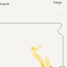


Cities Most Affected by Hail Storms of 8/28/2011
| Hail Size | Demographics of Zip Codes Affected | ||||||
|---|---|---|---|---|---|---|---|
| City | Count | Average | Largest | Pop Density | House Value | Income | Age |
| Freeman, SD | 2 | 2.50 | 3.00 | 5 | $52k | $31.0k | 47.7 |
Hail and Wind Damage Spotted on 8/28/2011
Filter by Report Type:Hail ReportsWind Reports
States Impacted
South Dakota, New York, New Hampshire, Iowa, Nebraska, Florida, Kansas, California, Texas, Oklahoma, Idaho, Utah, Oregon, WashingtonSouth Dakota
| Local Time | Report Details |
|---|---|
| 7:00 AM CDT | Quarter sized hail reported near Bridgewater, SD, 38.6 miles W of Sioux Falls, SD, continuation of quarter size hail. |
| 7:06 AM CDT | Quarter sized hail reported near Tulare, SD, 53.3 miles SSW of Aberdeen, SD, quarter size hail |
| 12:27 PM UTC | Storm damage reported in beadle county SD, 76.6 miles S of Aberdeen, SD |
| 7:31 AM CDT | Hen Egg sized hail reported near Freeman, SD, 37.6 miles WSW of Sioux Falls, SD |
| 1:05 PM UTC | Tree branches down in sanborn county SD, 63.3 miles WNW of Sioux Falls, SD |
| 8:08 AM CDT | Quarter sized hail reported near Avon, SD, 49.6 miles NE of Oneill, NE |
| 8:15 AM CDT | Tea Cup sized hail reported near Freeman, SD, 43.4 miles WSW of Sioux Falls, SD |
| 1:15 PM UTC | Tree limbs down in hanson county SD, 53.5 miles WNW of Sioux Falls, SD |
| 8:25 AM CDT | Half Dollar sized hail reported near Tyndall, SD, 50.6 miles NE of Oneill, NE |
| 8:45 AM CDT | Quarter sized hail reported near Parkston, SD, 55.2 miles W of Sioux Falls, SD |
New York
| Local Time | Report Details |
|---|---|
| 1:30 PM UTC | Microburst. numerous trees dow in warren county NY, 38.1 miles NNE of Schenectady, NY |
New Hampshire
| Local Time | Report Details |
|---|---|
| 2:50 PM UTC | Pond rd closed trees down in rockingham county NH, 67 miles SW of Portland, ME |
| 3:21 PM UTC | Depot rd closed... trees on wires in rockingham county NH, 55 miles SW of Portland, ME |
Iowa
| Local Time | Report Details |
|---|---|
| 3:21 PM UTC | Tree down on powerlin in woodbury county IA, 62 miles W of Storm Lake, IA |
| 3:26 PM UTC | Tree down on powerlin in woodbury county IA, 61.9 miles W of Storm Lake, IA |
| 3:28 PM UTC | Tree down on powerlin in woodbury county IA, 62 miles W of Storm Lake, IA |
| 5:00 PM UTC | Car possibly blown off interstate 68 in pottawattamie county IA, 16.7 miles NNE of Omaha, NE |
Nebraska
| Local Time | Report Details |
|---|---|
| 4:10 PM UTC | Large tree branches blown dow in thurston county NE, 71.8 miles NNW of Omaha, NE |
| 4:30 PM UTC | Small tree limbs blown dow in burt county NE, 48.5 miles NW of Omaha, NE |
| 12:20 PM CDT | Quarter sized hail reported near Ansley, NE, 67.3 miles WNW of Grand Island, NE |
| 2:45 PM CDT | Half Dollar sized hail reported near Funk, NE, 55.4 miles WSW of Grand Island, NE, hail to around half dollar size. hailed for 10 minutes starting at 245 pm. |
Florida
| Local Time | Report Details |
|---|---|
| 5:50 PM UTC | Usaf 54 ft tower number 1007 measured at 50 kt/58 mph wind gus in amz552 county FL, 36.9 miles E of Orlando, FL |
| 6:10 PM UTC | Usaf 54 ft wind tower number 311 measured a 55 kt/63 mph wind gus in brevard county FL, 45 miles E of Orlando, FL |
Kansas
| Local Time | Report Details |
|---|---|
| 8:22 PM UTC | Measured at the colby airport in thomas county KS, 0.6 miles SSW of Colby, KS |
| 8:25 PM UTC | Measured at colby airport in thomas county KS, 0.6 miles SSW of Colby, KS |
| 8:30 PM UTC | Storm damage reported in thomas county KS, 1.9 miles E of Colby, KS |
| 8:30 PM UTC | Numerous power poles and power lines down across town. several trees uprooted with numerous tree limbs broken at 8th and franklin. shingles were blown off courthouse ro in thomas county KS, 0.6 miles SSW of Colby, KS |
| 8:30 PM UTC | Trees uprooted in colb in thomas county KS, 0.6 miles SSW of Colby, KS |
| 3:38 PM CDT | Quarter sized hail reported near Gem, KS, 8.1 miles ENE of Colby, KS |
| 8:42 PM UTC | Nickel size hail also falling at report in thomas county KS, 8.1 miles ENE of Colby, KS |
| 4:22 PM CDT | Quarter sized hail reported near Monument, KS, 20.6 miles S of Colby, KS |
| 9:23 PM UTC | Power pole snapped one half of a mile of south of monument. grain bin also blown down. time estimated in logan county KS, 20.6 miles S of Colby, KS |
California
| Local Time | Report Details |
|---|---|
| 9:29 PM UTC | California highway patrol reported a wire down and sparking on morningside road at sunset roa in san bernardino county CA, 5.6 miles ENE of Yucca Valley, CA |
| 9:30 PM UTC | Fire department reported a roof and a porch off of a mobile home. the event time is an estimate off of rada in san bernardino county CA, 6.1 miles E of Yucca Valley, CA |
| 9:40 PM UTC | California highway patrol reported a tree down blocking the northbound lanes of sunset and oleander in joshua tree. a report of a shed in the roadway with metal debris in san bernardino county CA, 5.6 miles ENE of Yucca Valley, CA |
| 9:45 PM UTC | Thunderstorm winds stripped roofs and siding of aluminum sheds...blew of sections of the joshua tree library roof...blew over a landmark 36 foot wide billboard sign...t in san bernardino county CA, 6.1 miles E of Yucca Valley, CA |
| 9:52 PM UTC | Campo asos recorded a wind gust of 61 mph at 252 p in san diego county CA, 41 miles E of San Diego, CA |
| 9:52 PM UTC | Campo asos in san diego county CA, 41 miles E of San Diego, CA |
| 9:55 PM UTC | 5 power poles snapped on buckman springs road near highway 9 in san diego county CA, 40.4 miles E of San Diego, CA |
| 9:59 PM UTC | Several large tree branches fell onto property. power was lost soon afte in san diego county CA, 41 miles E of San Diego, CA |
| 9:59 PM UTC | Several large tree branches fell onto propert in san diego county CA, 41 miles E of San Diego, CA |
| 10:00 PM UTC | Sdge cmcsd in san diego county CA, 38.8 miles E of San Diego, CA |
| 10:11 PM UTC | California highway patrol reported a wire down on highway 6 in san bernardino county CA, 6 miles E of Yucca Valley, CA |
Texas
| Local Time | Report Details |
|---|---|
| 11:00 PM UTC | 3 inch limbs blown down. trampolines blown around. estimated 60 mph wind in sherman county TX, 80 miles N of Amarillo, TX |
| 11:01 PM UTC | Storm damage reported in sherman county TX, 79.2 miles N of Amarillo, TX |
Oklahoma
| Local Time | Report Details |
|---|---|
| 12:20 AM UTC | Storm damage reported in washita county OK, 73.2 miles SSE of Woodward, OK |
Idaho
| Local Time | Report Details |
|---|---|
| 12:29 AM UTC | Accumulated 0.30 inch of rainfall during past hour resulting from thunderstorm activit in caribou county ID, 70.9 miles SSE of Idaho Falls, ID |
| 12:29 AM UTC | Accumulated 0.30 inch of rainfall from passing thunderstor in caribou county ID, 70.9 miles SSE of Idaho Falls, ID |
| 12:31 AM UTC | Over 4000 idaho power customers mainly in canyon county without power starting around 530 pm. nampa...part of west meridian and part of caldwell. about 30 lightning str in canyon county ID, 18.5 miles W of Boise, ID |
| 1:30 AM UTC | Delayed report of wind damage in the eagle point subdivision approximately 4 miles east of lewiston. a section of a roof from a pole outbuilding was torn off. roughly t in nez perce county ID, 49.7 miles NW of Grangeville, ID |
| 1:30 AM UTC | Delayed report of wind damage to building. time estimated. klew t in nez perce county ID, 49.7 miles NW of Grangeville, ID |
| 5:16 AM UTC | Approximately 20 power poles snapped between the setters substation and us hwy 95. power lost to approximately 600 kootenai electric cooperative customer in kootenai county ID, 24.4 miles SE of Spokane, WA |
Utah
| Local Time | Report Details |
|---|---|
| 12:55 AM UTC | Wendover port of entry - 4227 ft in tooele county UT, 93.4 miles E of Elko, NV |
| 1:00 AM UTC | Wendover peak - 5087 ft in tooele county UT, 91.9 miles E of Elko, NV |
Oregon
| Local Time | Report Details |
|---|---|
| 1:35 AM UTC | Blowing dust visibility down to 200ft briefly. wind gust 63 mph. around 635 p in gilliam county OR, 82.1 miles NNE of Bend, OR |
Washington
| Local Time | Report Details |
|---|---|
| 5:16 AM UTC | Approximately 20 power poles snapped between the setters substation and us hwy 95. power lost to approximately 600 kootenai electric cooperative customer in spokane county WA, 19.3 miles SE of Spokane, WA |
Connect with Interactive Hail Maps