

Hail Map for Monday, August 29, 2011

Number of Impacted Households on 8/29/2011
0
Impacted by 1" or Larger Hail
0
Impacted by 1.75" or Larger Hail
0
Impacted by 2.5" or Larger Hail
Square Miles of Populated Area Impacted on 8/29/2011
0
Impacted by 1" or Larger Hail
0
Impacted by 1.75" or Larger Hail
0
Impacted by 2.5" or Larger Hail


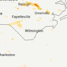


Cities Most Affected by Hail Storms of 8/29/2011
| Hail Size | Demographics of Zip Codes Affected | ||||||
|---|---|---|---|---|---|---|---|
| City | Count | Average | Largest | Pop Density | House Value | Income | Age |
| Greenville, NC | 1 | 1.75 | 1.75 | 841 | $122k | $35.2k | 25.0 |
| Rocky Mount, NC | 1 | 1.75 | 1.75 | 294 | $67k | $28.1k | 38.1 |
| Springer, NM | 1 | 1.75 | 1.75 | 0 | $52k | $29.3k | 45.3 |
Hail and Wind Damage Spotted on 8/29/2011
Filter by Report Type:Hail ReportsWind Reports
States Impacted
Nebraska, Montana, Florida, South Carolina, North Carolina, Colorado, South Dakota, New Mexico, WyomingNebraska
| Local Time | Report Details |
|---|---|
| 7:21 PM UTC | Storm damage reported in cheyenne county NE, 62 miles SE of Scottsbluff, NE |
| 9:45 PM UTC | 4 to 5 inch diameter branches broken off trees. also reported marble sized hail with the stor in sioux county NE, 78.7 miles N of Scottsbluff, NE |
| 3:55 PM MDT | Quarter sized hail reported near Harrison, NE, 72.4 miles N of Scottsbluff, NE, quarter sized hail was accompanied by strong wind gusts approaching 60 mph. |
| 11:03 PM UTC | Small branches dow in dawes county NE, 72.2 miles NNE of Scottsbluff, NE |
Montana
| Local Time | Report Details |
|---|---|
| 7:41 PM UTC | Storm damage reported in stillwater county MT, 30.9 miles WSW of Billings, MT |
| 8:15 PM UTC | Storm damage reported in yellowstone county MT, 15 miles WSW of Billings, MT |
| 8:30 PM UTC | Heavy rain and strong wind in yellowstone county MT, 3.2 miles E of Billings, MT |
| 9:30 PM UTC | Barbeque blown across a deck - estimated 60 mph wind gust in big horn county MT, 37.9 miles SE of Billings, MT |
| 9:45 PM UTC | Roof damage in musselshell county MT, 50.6 miles NNE of Billings, MT |
Florida
| Local Time | Report Details |
|---|---|
| 7:55 PM UTC | A couple of trees down along highway 90 west of greenvill in madison county FL, 35.3 miles E of Tallahassee, FL |
| 7:55 PM UTC | Eight to ten trees down along highway 90 west of greenville. road completely blocke in madison county FL, 35.3 miles E of Tallahassee, FL |
South Carolina
| Local Time | Report Details |
|---|---|
| 8:10 PM UTC | Two trees down along stringfellow roa in chester county SC, 38.5 miles SSW of Charlotte, NC |
| 4:20 PM EDT | Quarter sized hail reported near Chester, SC, 38.5 miles SSW of Charlotte, NC, dime to quarter sized hail fell for a short time on langley drive. strong wind with the storm but not enough to blow down any limbs. |
| 8:55 PM UTC | Trees down along mountain gap roa in chester county SC, 39.4 miles S of Charlotte, NC |
| 9:00 PM UTC | Tree down on johnsonville hwy near mcclam road. time of event estimated by rada in florence county SC, 47.7 miles NNE of Charleston, SC |
| 9:24 PM UTC | Tree down on thomas lane near old river road. time of event estimated by rada in florence county SC, 59.8 miles NNE of Charleston, SC |
| 9:24 PM UTC | Tree down near intersection of old river road and mcwhite circle. time of event estimated by rada in florence county SC, 59.2 miles NNE of Charleston, SC |
| 9:35 PM UTC | Public reported large limbs down and lots of limb debris in the roadway on copperhead road near calhoun roa in calhoun county SC, 58.5 miles NW of Charleston, SC |
| 9:35 PM UTC | Sheriff dispatch reported trees and powerlines down on copperhead road near old bellville roa in calhoun county SC, 58.5 miles NW of Charleston, SC |
| 9:45 PM UTC | Highway patrol reported a tree down along hwy 178 two miles north of the town of nort in orangeburg county SC, 50 miles ENE of Augusta, GA |
| 10:10 PM UTC | Highway patrol reported power lines down at the intersection of cedarcrest road and two notch roa in lexington county SC, 55.1 miles NE of Augusta, GA |
| 10:24 PM UTC | Highway patrol reported trees down in the arrowwood road and bush river road are in richland county SC, 63.1 miles NE of Augusta, GA |
| 10:28 PM UTC | Sheriff dispatch reported trees down near the town of nort in orangeburg county SC, 50.6 miles E of Augusta, GA |
| 10:41 PM UTC | Highway patrol reported a tree down at the intersection of hwy 6 and farming creek roa in richland county SC, 61.1 miles NE of Augusta, GA |
| 11:39 PM UTC | Sheriff dispatch reported a couple large limbs down and trees down in camde in kershaw county SC, 67.6 miles S of Charlotte, NC |
| 2:23 AM UTC | Highway department reported trees down along state park road near aiken state natural are in aiken county SC, 28.4 miles E of Augusta, GA |
North Carolina
| Local Time | Report Details |
|---|---|
| 4:26 PM EDT | Quarter sized hail reported near Raleigh, NC, 7.9 miles NNW of Raleigh, NC, 1 inch hail at ray road |
| 4:32 PM EDT | Quarter sized hail reported near Raleigh, NC, 7.9 miles N of Raleigh, NC, 1 inch hail measured at six forks road and strickland road |
| 4:33 PM EDT | Quarter sized hail reported near Cary, NC, 8.5 miles WSW of Raleigh, NC, dime to quarter size hail for several minutes. 68 |
| 8:33 PM UTC | Powerlines down along jack currie rd between grassy island rd and hwy 10 in richmond county NC, 47.3 miles E of Charlotte, NC |
| 8:35 PM UTC | Couple of trees down on highway 109 near grassy island road in richmond county NC, 47.9 miles E of Charlotte, NC |
| 4:35 PM EDT | Quarter sized hail reported near Raleigh, NC, 8.6 miles N of Raleigh, NC, 1 inch hail measured at six forks road and lead mine road |
| 4:35 PM EDT | Half Dollar sized hail reported near Raleigh, NC, 8.2 miles NNW of Raleigh, NC |
| 4:45 PM EDT | Quarter sized hail reported near Raleigh, NC, 8.8 miles NNE of Raleigh, NC, nickel to quarter size hail reported and resulted in damage to landscape plants. |
| 8:46 PM UTC | Trees down in franklin county NC, 25.1 miles ENE of Raleigh, NC |
| 8:48 PM UTC | One tree down near the intersection of gus mcghee road and pearces road in franklin county NC, 23.5 miles ENE of Raleigh, NC |
| 4:48 PM EDT | Quarter sized hail reported near Raleigh, NC, 8.9 miles NNE of Raleigh, NC, reported on durant rd |
| 4:50 PM EDT | Half Dollar sized hail reported near Stem, NC, 31.7 miles N of Raleigh, NC, half dollar size hail measured at north ridge drive |
| 8:58 PM UTC | Tree down on town creek indian mound r in montgomery county NC, 51.4 miles E of Charlotte, NC |
| 5:00 PM EDT | Half Dollar sized hail reported near Louisburg, NC, 25.1 miles NE of Raleigh, NC, trained spotter reports quarter to half-dollar size hail |
| 5:10 PM EDT | Quarter sized hail reported near Graham, NC, 46.2 miles WNW of Raleigh, NC, quarter size hail at forence and todd streets |
| 9:15 PM UTC | Tree down on house in alamance county NC, 48 miles WNW of Raleigh, NC |
| 9:15 PM UTC | Multiple trees down in alamance county NC, 47 miles WNW of Raleigh, NC |
| 9:15 PM UTC | Two trees blown down that blocked turner road in alamance county NC, 41.3 miles WNW of Raleigh, NC |
| 9:26 PM UTC | Multiple trees down in alamance county NC, 46.5 miles WNW of Raleigh, NC |
| 9:30 PM UTC | One tree down across culbreth road near berea in granville county NC, 36.5 miles N of Raleigh, NC |
| 9:30 PM UTC | Tree down in franklin county NC, 28.1 miles ENE of Raleigh, NC |
| 10:10 PM UTC | Tree down at the 1500 block of us 64 wes in chatham county NC, 31.6 miles W of Raleigh, NC |
| 6:13 PM EDT | Quarter sized hail reported near Rocky Mount, NC, 45.2 miles ENE of Raleigh, NC |
| 10:18 PM UTC | Tree on a car on moncure pittsboro r in chatham county NC, 30.8 miles W of Raleigh, NC |
| 6:35 PM EDT | Half Dollar sized hail reported near Rocky Mount, NC, 47.4 miles ENE of Raleigh, NC |
| 6:35 PM EDT | Golf Ball sized hail reported near Rocky Mount, NC, 52.8 miles E of Raleigh, NC |
| 10:40 PM UTC | Tree and power lines down at pea ridge rd and cape fear d in chatham county NC, 24.7 miles WSW of Raleigh, NC |
| 10:41 PM UTC | Powerlines down at pea ridge rd and woodhaven d in chatham county NC, 23.7 miles WSW of Raleigh, NC |
| 6:43 PM EDT | Quarter sized hail reported near Macclesfield, NC, 52.4 miles E of Raleigh, NC |
| 6:43 PM EDT | Quarter sized hail reported near Pinetops, NC, 54.2 miles E of Raleigh, NC, quarter size hail measured at intersection of hwy 43 and jenkins farm road |
| 10:52 PM UTC | Trees down in chatham county NC, 25.3 miles WSW of Raleigh, NC |
| 11:05 PM UTC | Thunderstorm wind caused damage to house in the sharp point community in pitt county NC, 61.5 miles E of Raleigh, NC |
| 11:10 PM UTC | Tree down on powerline at creedmore and lynn in wake county NC, 6.8 miles NNE of Raleigh, NC |
| 11:20 PM UTC | Tree down on powerline at new hope and buffalo r in wake county NC, 5.1 miles NE of Raleigh, NC |
| 11:20 PM UTC | Tree down on powerline at creedmore and lynn in wake county NC, 6.8 miles NNE of Raleigh, NC |
| 7:43 PM EDT | Golf Ball sized hail reported near Greenville, NC, 72.7 miles E of Raleigh, NC, golf size hail near hwy 33 and hwy 264 |
| 1:00 AM UTC | One tree down on camden road near the county line in hoke county NC, 61.4 miles SSW of Raleigh, NC |
| 1:00 AM UTC | One tree down near intersection of black bridge road and home stretch drive in cumberland county NC, 60.7 miles SSW of Raleigh, NC |
| 1:02 AM UTC | One tree down near the intersection of st. pauls road and pate road in hoke county NC, 65.2 miles SSW of Raleigh, NC |
| 1:15 AM UTC | One tree blown down near vander on judson church roa in cumberland county NC, 54.4 miles S of Raleigh, NC |
| 1:20 AM UTC | Tree down at the intersection of west david and parnell stree in robeson county NC, 64.5 miles SSW of Raleigh, NC |
| 1:38 AM UTC | One tree down and several large tree limbs down on green street and raiston stree in wilson county NC, 40.8 miles E of Raleigh, NC |
| 1:50 AM UTC | Tree down on hwy 7 in robeson county NC, 66.1 miles WNW of Wilmington, NC |
| 3:05 AM UTC | Tree down on mercer mill roa in bladen county NC, 45.4 miles NW of Wilmington, NC |
Colorado
| Local Time | Report Details |
|---|---|
| 3:17 PM MDT | Quarter sized hail reported near Ovid, CO, 59.3 miles NNE of Yuma, CO |
| 5:16 PM MDT | Half Dollar sized hail reported near Deer Trail, CO, 58.9 miles WSW of Yuma, CO |
| 5:17 PM MDT | Quarter sized hail reported near Deer Trail, CO, 59.8 miles WSW of Yuma, CO |
| 6:37 PM MDT | Quarter sized hail reported near Genoa, CO, 64 miles SW of Yuma, CO |
South Dakota
| Local Time | Report Details |
|---|---|
| 3:27 PM MDT | Half Dollar sized hail reported near Edgemont, SD, 80.5 miles N of Scottsbluff, NE |
New Mexico
| Local Time | Report Details |
|---|---|
| 9:53 PM UTC | Kabq aso in bernalillo county NM, 3.5 miles SSE of Albuquerque, NM |
| 4:30 PM MDT | Golf Ball sized hail reported near Springer, NM, 54.9 miles E of Taos, NM |
| 12:26 AM UTC | Kcao aso in union county NM, 94.3 miles NNE of Tucumcari, NM |
| 12:30 AM UTC | Roof blown off a house...numerous fences blow down in union county NM, 93 miles NNE of Tucumcari, NM |
Wyoming
| Local Time | Report Details |
|---|---|
| 12:09 AM UTC | Grass and oats flattened in campbell county WY, 36.2 miles NW of Gillette, WY |
| 6:15 PM MDT | Quarter sized hail reported near Gillette, WY, 33.4 miles NNW of Gillette, WY |
| 6:30 PM MDT | Half Dollar sized hail reported near Gillette, WY, 18.8 miles NNW of Gillette, WY |
| 12:55 AM UTC | Storm damage reported in campbell county WY, 4.9 miles NNW of Gillette, WY |
Connect with Interactive Hail Maps