

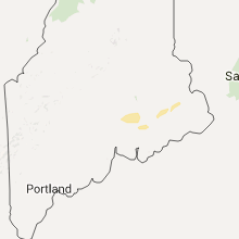
Hail Map for Wednesday, August 5, 2015

Number of Impacted Households on 8/5/2015
0
Impacted by 1" or Larger Hail
0
Impacted by 1.75" or Larger Hail
0
Impacted by 2.5" or Larger Hail
Square Miles of Populated Area Impacted on 8/5/2015
0
Impacted by 1" or Larger Hail
0
Impacted by 1.75" or Larger Hail
0
Impacted by 2.5" or Larger Hail


Cities Most Affected by Hail Storms of 8/5/2015
| Hail Size | Demographics of Zip Codes Affected | ||||||
|---|---|---|---|---|---|---|---|
| City | Count | Average | Largest | Pop Density | House Value | Income | Age |
Hail and Wind Damage Spotted on 8/5/2015
Filter by Report Type:Hail ReportsWind Reports
States Impacted
Arkansas, Tennessee, South Carolina, North Carolina, Kentucky, Idaho, Maine, Virginia, Texas, Mississippi, South Dakota, Wyoming, Utah, Colorado, Montana, OklahomaArkansas
| Local Time | Report Details |
|---|---|
| 11:00 AM CDT | Large tree uprooted on cherry hill drive just outside of fayetteville. relayed by broadcast media via social media. time estimated via radar and data from the kfyv obse in washington county AR, 49.1 miles NNE of Fort Smith, AR |
| 1:30 PM CDT | A tree fell onto a hous in izard county AR, 95.6 miles N of Little Rock, AR |
| 1:39 PM CDT | Large tree was reported across road in petit jean state par in conway county AR, 46.8 miles NW of Little Rock, AR |
| 1:55 PM CDT | Numerous trees down in oppel in conway county AR, 37.6 miles NW of Little Rock, AR |
| 2:08 PM CDT | Trees and power lines down across the city of conwa in faulkner county AR, 25.6 miles NNW of Little Rock, AR |
| 2:30 PM CDT | Trees down on fortson roa in faulkner county AR, 19.2 miles NNE of Little Rock, AR |
| 2:55 PM CDT | A large tree fell on a house and a roof was partially taken off of a apartment comple in white county AR, 45.8 miles NE of Little Rock, AR |
| 3:55 PM CDT | Reports of several trees down in the marked tree are in poinsett county AR, 33.6 miles NW of Memphis, TN |
| 10:10 PM CDT | Trees and power lines down at highway 7 and bakers creek roa in pope county AR, 62.9 miles NW of Little Rock, AR |
| 11:03 PM CDT | Some structural damage was reported...as well as trees and power lines blown dow in woodruff county AR, 65.1 miles NE of Little Rock, AR |
| 11:10 PM CDT | Tree down on house and caused fire. minor damage to house due to tree initiall in perry county AR, 38.3 miles WNW of Little Rock, AR |
Tennessee
| Local Time | Report Details |
|---|---|
| 1:40 PM CDT | Trees were blown down in spring hill in maury county TN, 30.5 miles SSW of Nashville, TN |
| 4:03 PM CDT | Trees down in alexandria. event time radar estimate in de kalb county TN, 42.3 miles E of Nashville, TN |
| 4:20 PM CDT | Trees were reportedly blown down on cookeville highway in de kalb county TN, 59 miles E of Nashville, TN |
| 4:37 PM CDT | Trees down near brunswick and jack bond road in shelby county TN, 23.8 miles ENE of Memphis, TN |
| 4:40 PM CDT | Several large trees down and telephone poles snapped in half near old memphis road. reports of trees on a few houses in covingto in tipton county TN, 36.7 miles NE of Memphis, TN |
| 4:42 PM CDT | Trees down near walnut grove roa in shelby county TN, 15.2 miles ESE of Memphis, TN |
| 4:45 PM CDT | Trees down and power out around colliervill in shelby county TN, 21.8 miles ESE of Memphis, TN |
| 4:45 PM CDT | Large tree down at belle meade blocking roadwa in shelby county TN, 4.1 miles ESE of Memphis, TN |
| 4:45 PM CDT | Large tree dow in shelby county TN, 9 miles S of Memphis, TN |
| 5:50 PM EDT | Lots of trees down and one railroad arm blown down. wjhl measured wind gust of 56 mp in washington county TN, 19.9 miles SSW of Bristol, TN |
| 4:50 PM CDT | Fences damaged at briarcrest high school via photo submitted on twitte in shelby county TN, 15.2 miles E of Memphis, TN |
| 4:55 PM CDT | Large tree down near white station and gwynn in shelby county TN, 4.1 miles ESE of Memphis, TN |
| 5:00 PM CDT | Trained spotter estimated wind gusting to 70-75 mp in fayette county TN, 35 miles E of Memphis, TN |
| 5:00 PM CDT | Power lines down near crestview at bartlett roa in shelby county TN, 12.8 miles ENE of Memphis, TN |
| 6:05 PM EDT | Several trees and power lines down in and around elizabethton. large tree limbs down on cedar grove road als in carter county TN, 17.4 miles S of Bristol, TN |
| 5:35 PM CDT | 61 mph gust measured at mckellar-sipes airpor in madison county TN, 38.8 miles SSW of Mc Kenzie, TN |
| 5:50 PM CDT | Several trees down around jackso in madison county TN, 38.8 miles SSW of Mc Kenzie, TN |
| 5:55 PM CDT | Trained spotter measured 72 knot gust west of humboldt with several trees dow in crockett county TN, 33.6 miles SW of Mc Kenzie, TN |
South Carolina
| Local Time | Report Details |
|---|---|
| 2:55 PM EDT | 2 retired nws employees and media sources report a tree blown along holland road between bethel road and highway 14. other large limbs down along adams mill road at the in greenville county SC, 20.2 miles E of Greenville, SC |
| 3:07 PM EDT | Storm damage reported in florence county SC, 70.5 miles NNE of Charleston, SC |
| 3:30 PM EDT | Report of trees and powerlines down at and near florence regional airpor in florence county SC, 71.1 miles NNE of Charleston, SC |
| 3:30 PM EDT | Emergency manager reports trees and powerlines down along e palmetto st... minor damage to small sheds and windows blown out at florence regional airport terminal. time in florence county SC, 71.2 miles NNE of Charleston, SC |
| 3:50 PM EDT | Highway patrol and news media report numerous trees down in richland county including tree on car sumter and wheat in richland county SC, 64.8 miles ENE of Augusta, GA |
| 3:50 PM EDT | Twitter report of large tree down with house damage gladden st and millwood avenue in richland county SC, 66.7 miles ENE of Augusta, GA |
| 3:59 PM EDT | Several trees down in quinb in florence county SC, 73.1 miles NNE of Charleston, SC |
| 4:25 PM EDT | Report of a few trees down on pamplico hwy interrupting traffic. time estimated by rada in florence county SC, 68.1 miles NNE of Charleston, SC |
| 6:16 PM EDT | Sheriff office reported trees down near ruby in chesterfield county SC, 50.8 miles SE of Charlotte, NC |
| 7:08 PM EDT | Highway patrol reports trees down in this area...along holly springs road north of lyma in spartanburg county SC, 27.5 miles ENE of Greenville, SC |
| 7:10 PM EDT | A tree in roadway near intersection of highway 176 and bloomwood height in spartanburg county SC, 32.9 miles ENE of Greenville, SC |
| 7:10 PM EDT | Numerous trees down in inman as caller mentioned ridge street and foster street. caller unable to leave the area due to trees blocking the road in spartanburg county SC, 32.7 miles ENE of Greenville, SC |
| 8:00 PM EDT | Power lines down along groce meadow road near lake robinso in greenville county SC, 20.3 miles ENE of Greenville, SC |
| 8:05 PM EDT | A few trees down across eastern greenville count in greenville county SC, 20.2 miles ENE of Greenville, SC |
| 8:15 PM EDT | Tree down on wood drive near the intersection of highway 14 and south buncombe roa in greenville county SC, 21.2 miles ENE of Greenville, SC |
| 8:27 PM EDT | Trees down...barn destroyed and metal roofing wrapped around tree in anderson county SC, 23.8 miles S of Greenville, SC |
| 8:30 PM EDT | Tree down along mayfield road to the north of abner creek roa in spartanburg county SC, 25.3 miles E of Greenville, SC |
| 8:36 PM EDT | A few trees and power lines with at least one or two power poles down in the homeland park area. time estimated by rada in anderson county SC, 23.7 miles S of Greenville, SC |
| 8:36 PM EDT | Tree on a house on palmer street on the east side of homeland par in anderson county SC, 23.7 miles S of Greenville, SC |
| 9:07 PM EDT | A few large limbs down and a few power lines down as the storm came throug in spartanburg county SC, 37.8 miles ESE of Greenville, SC |
| 9:08 PM EDT | Tree blocking road near the intersection of shaw road and walnut grove roa in spartanburg county SC, 38.1 miles E of Greenville, SC |
| 9:35 PM EDT | One tree down in the city of union. time was estimated based on radar base velocity when the gust front arrive in union county SC, 56.3 miles E of Greenville, SC |
North Carolina
| Local Time | Report Details |
|---|---|
| 3:42 PM EDT | Multiple trees down across the city of bladenboro. trees blocking access to ballpark rd near hwy 211. time estimated by rada in bladen county NC, 53.1 miles WNW of Wilmington, NC |
| 4:45 PM EDT | Report of trees and powerlines down on industrial blvd... birchwood trail and peacock rd. time estimated by rada in columbus county NC, 47.6 miles W of Wilmington, NC |
| 6:19 PM EDT | One tree down blocking northbound rt 194 near broadstone roa in watauga county NC, 36 miles SE of Bristol, TN |
| 6:32 PM EDT | One tree down on gazebo in valle cruci in watauga county NC, 35.5 miles SE of Bristol, TN |
| 6:38 PM EDT | One tree down along highway 105 near earl lyons roa in watauga county NC, 38.3 miles SE of Bristol, TN |
| 7:28 PM EDT | Multiple trees and power lines down on woodruff road. via social medi in yadkin county NC, 70.3 miles N of Charlotte, NC |
| 7:35 PM EDT | Green creek area as numerous trees down in southeastern polk county as the following roads in particular had many trees down...melvin hill road...stacey road...chesnee in polk county NC, 41.6 miles NE of Greenville, SC |
| 7:48 PM EDT | Multiple trees and power lines down in town of hamptonville in yadkin county NC, 61.9 miles N of Charlotte, NC |
| 8:00 PM EDT | Numerous limbs down...mostly small but a few 2 inches in diameter along dewitt owens roa in rutherford county NC, 49.5 miles NE of Greenville, SC |
| 8:37 PM EDT | Multiple trees down throughout the town in stokes county NC, 58.3 miles SSW of Roanoke, VA |
| 8:50 PM EDT | Report of trees down in the twin creeks development near arcadia. relayed by broadcast media. radar estimated tim in davidson county NC, 60.6 miles NNE of Charlotte, NC |
| 8:55 PM EDT | Multiple trees down throughout the town in stokes county NC, 57.2 miles SSW of Roanoke, VA |
| 9:11 PM EDT | Multiple trees down throughout the town in stokes county NC, 72.2 miles SSW of Roanoke, VA |
| 9:35 PM EDT | Two powerlines down in high point causing up to 1200 power outages. radar estimated tim in guilford county NC, 69 miles NE of Charlotte, NC |
| 9:40 PM EDT | Tree down at birnamwood trail and bridle ridge pkwy... time estimated by radar in guilford county NC, 72.4 miles WNW of Raleigh, NC |
| 9:49 PM EDT | Tree down at davis mill and steeple chase... time estimated by radar in guilford county NC, 65.9 miles W of Raleigh, NC |
Kentucky
| Local Time | Report Details |
|---|---|
| 4:00 PM EDT | Powerline blow down on cemetery roa in whitley county KY, 55.5 miles NNW of Knoxville, TN |
| 4:55 PM EDT | Trees blown down onto powerlines along ky highway 149 in bell county KY, 54.1 miles N of Knoxville, TN |
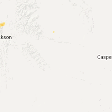
Idaho
| Local Time | Report Details |
|---|---|
| 2:15 PM MDT | Measured at the taber inl sit in bingham county ID, 34.7 miles WSW of Idaho Falls, ID |
| 2:55 PM MDT | Kidk tv shared images of potato crop damage from wind rain and hail - crops are flattened in bingham county ID, 8.7 miles SSW of Idaho Falls, ID |
| 2:55 PM MDT | Measured at the kettle butte inl site at 255pm mdt this afternoo in bonneville county ID, 15 miles WNW of Idaho Falls, ID |
Maine
| Local Time | Report Details |
|---|---|
| 4:15 PM EDT | Quarter sized hail reported near Bangor, ME, 0.5 miles WSW of Bangor, ME |
| 4:25 PM EDT | Tree down on power line on route 2. several trees blown down throughout tow in penobscot county ME, 4 miles NE of Bangor, ME |
Virginia
| Local Time | Report Details |
|---|---|
| 4:56 PM EDT | Ping Pong Ball sized hail reported near Shipman, VA, 64.6 miles WNW of Richmond, VA |
Texas
| Local Time | Report Details |
|---|---|
| 4:10 PM CDT | Measured by the west texas mesonet in lamb county TX, 43 miles NW of Lubbock, TX |
Mississippi
| Local Time | Report Details |
|---|---|
| 4:15 PM CDT | Report of power pole blown down in rosedale. time estimated on rada in bolivar county MS, 89.9 miles NE of Bastrop, LA |
| 4:50 PM CDT | Large tree down near center hill road north of desoto roa in desoto county MS, 18.5 miles SE of Memphis, TN |
| 5:45 PM CDT | Dispatcher reported major roof damage to a home with several trees down across tippah count in tippah county MS, 69.3 miles ESE of Memphis, TN |
South Dakota
| Local Time | Report Details |
|---|---|
| 4:21 PM CDT | Quarter sized hail reported near Selby, SD, 70.5 miles N of Pierre, SD, report relayed via nssl shave |
| 12:47 AM CDT | Quarter sized hail reported near Columbia, SD, 12.7 miles NE of Aberdeen, SD |
Wyoming
| Local Time | Report Details |
|---|---|
| 4:54 PM MDT | Storm damage reported in campbell county WY, 4.3 miles NNW of Gillette, WY |
| 5:01 PM MDT | Storm damage reported in campbell county WY, 4.3 miles NNW of Gillette, WY |
| 5:25 PM MDT | Storm damage reported in crook county WY, 34.7 miles E of Gillette, WY |
| 5:33 PM MDT | Storm damage reported in crook county WY, 34.7 miles E of Gillette, WY |
| 6:30 PM MDT | Storm damage reported in weston county WY, 63.7 miles WSW of Rapid City, SD |
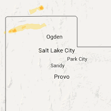
Utah
| Local Time | Report Details |
|---|---|
| 5:20 PM MDT | Ping Pong Ball sized hail reported near , , 74.9 miles NNW of Salt Lake City, UT, quarter to ping pong ball sized hail observed and video taped along interstate 84. |
Colorado
| Local Time | Report Details |
|---|---|
| 5:54 PM MDT | Ping Pong Ball sized hail reported near Peetz, CO, 55 miles NNW of Yuma, CO |
| 6:04 PM MDT | Quarter sized hail reported near Iliff, CO, 51.6 miles NNW of Yuma, CO |
| 6:10 PM MDT | Quarter sized hail reported near Iliff, CO, 50 miles NNW of Yuma, CO |
Montana
| Local Time | Report Details |
|---|---|
| 6:05 PM MDT | Storm damage reported in yellowstone county MT, 16.1 miles WNW of Billings, MT |
| 6:15 PM MDT | Storm damage reported in yellowstone county MT, 6.1 miles W of Billings, MT |
| 6:22 PM MDT | Storm damage reported in yellowstone county MT, 2.8 miles NW of Billings, MT |
| 6:50 PM MDT | Storm damage reported in yellowstone county MT, 11.6 miles NE of Billings, MT |
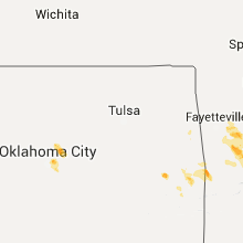
Oklahoma
| Local Time | Report Details |
|---|---|
| 8:09 PM CDT | Quarter sized hail reported near Edmond, OK, 21.8 miles NNE of Oklahoma City, OK, via mping. |
| 8:56 PM CDT | Half Dollar sized hail reported near Luther, OK, 21.4 miles NE of Oklahoma City, OK |
| 9:28 PM CDT | Large tree branches snappe in oklahoma county OK, 8.7 miles NNE of Oklahoma City, OK |
Connect with Interactive Hail Maps