

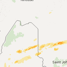
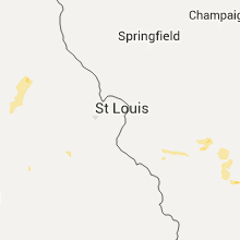
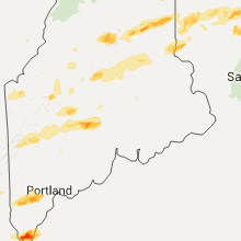
Hail Map for Tuesday, August 4, 2015

Number of Impacted Households on 8/4/2015
0
Impacted by 1" or Larger Hail
0
Impacted by 1.75" or Larger Hail
0
Impacted by 2.5" or Larger Hail
Square Miles of Populated Area Impacted on 8/4/2015
0
Impacted by 1" or Larger Hail
0
Impacted by 1.75" or Larger Hail
0
Impacted by 2.5" or Larger Hail


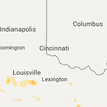


Cities Most Affected by Hail Storms of 8/4/2015
| Hail Size | Demographics of Zip Codes Affected | ||||||
|---|---|---|---|---|---|---|---|
| City | Count | Average | Largest | Pop Density | House Value | Income | Age |
| York, ME | 2 | 1.88 | 2.00 | 261 | $192k | $54.4k | 48.9 |
| Dighton, KS | 2 | 1.88 | 2.00 | 0 | $46k | $35.1k | 47.3 |
| Colby, KS | 2 | 1.88 | 2.00 | 13 | $79k | $37.3k | 35.7 |
| Waterboro, ME | 1 | 2.50 | 2.50 | 90 | $98k | $41.9k | 38.5 |
| Bird City, KS | 1 | 2.00 | 2.00 | 1 | $43k | $27.5k | 46.6 |
| Waltham, MA | 1 | 2.00 | 2.00 | 3143 | $237k | $57.2k | 39.2 |
| Valatie, NY | 1 | 2.00 | 2.00 | 150 | $130k | $51.6k | 45.3 |
| Jamaica Plain, MA | 1 | 2.00 | 2.00 | 9618 | $277k | $46.6k | 34.7 |
| Littleton, MA | 1 | 2.00 | 2.00 | 520 | $243k | $71.4k | 43.0 |
| Newtonville, MA | 1 | 1.75 | 1.75 | 6574 | $379k | $83.1k | 42.0 |
| Boston, MA | 1 | 1.75 | 1.75 | 14927 | $206k | $39.6k | 32.0 |
| Petersham, MA | 1 | 1.75 | 1.75 | 22 | $144k | $47.9k | 47.7 |
| Ransom, KS | 1 | 1.75 | 1.75 | 1 | $39k | $34.9k | 52.5 |
| Gardner, MA | 1 | 1.75 | 1.75 | 817 | $106k | $37.3k | 40.7 |
| Marlborough, MA | 1 | 1.75 | 1.75 | 1877 | $191k | $56.9k | 38.5 |
| Georgetown, MA | 1 | 1.75 | 1.75 | 651 | $251k | $76.3k | 41.8 |
| Cambridge, MA | 1 | 1.75 | 1.75 | 10115 | $626k | $55.7k | 28.7 |
| Westminster, MA | 1 | 1.75 | 1.75 | 191 | $142k | $57.8k | 42.8 |
| Houlton, ME | 1 | 1.75 | 1.75 | 38 | $59k | $27.4k | 43.2 |
| Smyrna Mills, ME | 1 | 1.75 | 1.75 | 2 | $45k | $27.3k | 41.3 |
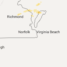
Hail and Wind Damage Spotted on 8/4/2015
Filter by Report Type:Hail ReportsWind Reports
States Impacted
Massachusetts, Vermont, New York, New Hampshire, Nebraska, Maine, Kansas, Georgia, North Carolina, Florida, Virginia, Missouri, Colorado, Kentucky, Indiana, Idaho, Maryland, DelawareMassachusetts
| Local Time | Report Details |
|---|---|
| 8:00 AM EDT | Tree and wires down on winona street in essex county MA, 54.7 miles NNE of Providence, RI |
| 8:02 AM EDT | Lowell street closed due to multiple trees down in essex county MA, 54.7 miles NNE of Providence, RI |
| 8:05 AM EDT | Trees and wires down cover at chipman way in barnstable county MA, 71.7 miles E of Providence, RI |
| 12:55 PM EDT | Tree on to house on flat hills road in hampshire county MA, 68.7 miles NW of Providence, RI |
| 1:20 PM EDT | Quarter sized hail reported near Pittsfield, MA, 43.6 miles ESE of Schenectady, NY, hail at intersection of dalton ave and westminster ave |
| 1:25 PM EDT | Quarter sized hail reported near Athol, MA, 68.1 miles NW of Providence, RI |
| 1:26 PM EDT | Quarter sized hail reported near Dalton, MA, 46.3 miles ESE of Schenectady, NY |
| 1:30 PM EDT | Quarter sized hail reported near Dalton, MA, 49.5 miles ESE of Schenectady, NY |
| 1:30 PM EDT | Quarter sized hail reported near South Egremont, MA, 52 miles SSE of Schenectady, NY |
| 1:36 PM EDT | Golf Ball sized hail reported near Petersham, MA, 60.9 miles NW of Providence, RI |
| 1:39 PM EDT | Half Dollar sized hail reported near Templeton, MA, 61 miles NNW of Providence, RI |
| 1:40 PM EDT | Quarter sized hail reported near Winchendon, MA, 67.9 miles NNW of Providence, RI |
| 1:44 PM EDT | Ping Pong Ball sized hail reported near Winchendon, MA, 67.9 miles NNW of Providence, RI |
| 1:45 PM EDT | Quarter sized hail reported near Gardner, MA, 60.3 miles NNW of Providence, RI |
| 1:45 PM EDT | Half Dollar sized hail reported near Royalston, MA, 71.3 miles NNW of Providence, RI |
| 1:47 PM EDT | Golf Ball sized hail reported near Gardner, MA, 60.3 miles NNW of Providence, RI |
| 1:48 PM EDT | Tree down on car in hampshire county MA, 58.8 miles ESE of Schenectady, NY |
| 1:49 PM EDT | Quarter sized hail reported near Ashburnham, MA, 61.8 miles NNW of Providence, RI |
| 1:53 PM EDT | Dingle road large tree and wires down in hampshire county MA, 58.4 miles ESE of Schenectady, NY |
| 1:55 PM EDT | 8 trees down...on dodwells road...fairgrounds road and route 112 where tree broke a telephone cable. large limb down on house on mount roa in hampshire county MA, 58.8 miles ESE of Schenectady, NY |
| 1:56 PM EDT | Quarter sized hail reported near Westminster, MA, 56.3 miles NNW of Providence, RI |
| 1:57 PM EDT | Golf Ball sized hail reported near Westminster, MA, 56.3 miles NNW of Providence, RI |
| 2:00 PM EDT | Quarter sized hail reported near Ayer, MA, 51.6 miles N of Providence, RI |
| 2:04 PM EDT | Ping Pong Ball sized hail reported near Leominster, MA, 51.9 miles NNW of Providence, RI |
| 2:09 PM EDT | Quarter sized hail reported near Leominster, MA, 51.9 miles NNW of Providence, RI |
| 2:13 PM EDT | Half Dollar sized hail reported near Petersham, MA, 60.9 miles NW of Providence, RI, hail covering common |
| 2:14 PM EDT | Quarter sized hail reported near Fitchburg, MA, 55.9 miles NNW of Providence, RI |
| 2:25 PM EDT | Quarter sized hail reported near Shirley, MA, 50.9 miles NNW of Providence, RI |
| 2:26 PM EDT | Wires down in hampshire county MA, 70.3 miles WNW of Providence, RI |
| 2:29 PM EDT | Multiple trees and wires down on long plain road and claverack road in franklin county MA, 71.6 miles ESE of Schenectady, NY |
| 2:34 PM EDT | Quarter sized hail reported near Acton, MA, 46 miles N of Providence, RI |
| 2:35 PM EDT | Hen Egg sized hail reported near Littleton, MA, 49.7 miles N of Providence, RI |
| 2:37 PM EDT | Quarter sized hail reported near Westford, MA, 52.2 miles N of Providence, RI |
| 2:38 PM EDT | Tree down on house in hampshire county MA, 72.9 miles ESE of Schenectady, NY |
| 2:39 PM EDT | Trees and wires down on massachusetts avenue near stow and burroughs roads in middlesex county MA, 46.4 miles N of Providence, RI |
| 2:40 PM EDT | Tree down dahlia drive in middlesex county MA, 49.7 miles N of Providence, RI |
| 2:42 PM EDT | Wires down gray road in middlesex county MA, 49.7 miles N of Providence, RI |
| 2:46 PM EDT | Multiple trees down on foster street and nagog hill road in middlesex county MA, 49.7 miles N of Providence, RI |
| 2:59 PM EDT | Quarter sized hail reported near Barre, MA, 54.6 miles NW of Providence, RI |
| 2:59 PM EDT | Quarter sized hail reported near Rutland, MA, 46.7 miles NW of Providence, RI |
| 2:59 PM EDT | Ping Pong Ball sized hail reported near Barre, MA, 54.6 miles NW of Providence, RI |
| 3:00 PM EDT | Quarter sized hail reported near Wilmington, MA, 51.6 miles NNE of Providence, RI |
| 3:00 PM EDT | Multiple trees down. tree on car on old marlboro road in middlesex county MA, 44 miles N of Providence, RI |
| 3:00 PM EDT | Trees down on wires on sunrise avenue...williamsville road and pleasant street in worcester county MA, 54.6 miles NW of Providence, RI |
| 3:03 PM EDT | Tree down...large limbs down...tree on car on near route 111. shingles blown off side of roo in middlesex county MA, 45.4 miles N of Providence, RI |
| 3:05 PM EDT | Trees and wires down on house on parker road in middlesex county MA, 50.5 miles NNE of Providence, RI |
| 3:09 PM EDT | Quarter sized hail reported near Hubbardston, MA, 54.1 miles NW of Providence, RI |
| 3:10 PM EDT | Two trees down. one tree blocking one side of route 111 in worcester county MA, 47.5 miles N of Providence, RI |
| 3:10 PM EDT | Quarter sized hail reported near Rutland, MA, 46.7 miles NW of Providence, RI |
| 3:10 PM EDT | Tree down on a car on lake road in worcester county MA, 44.3 miles NW of Providence, RI |
| 3:10 PM EDT | Trees down on main street...conant street and wang road in essex county MA, 52.8 miles NNE of Providence, RI |
| 3:15 PM EDT | Tree down on conant street in essex county MA, 57.8 miles NNE of Providence, RI |
| 3:15 PM EDT | Tree and large power line through house on hamilton road...wires down on lowell street...tree and wires down on harrison avenue...tree down on abington roa in essex county MA, 54.7 miles NNE of Providence, RI |
| 3:15 PM EDT | Tree down on a car on hamilton road in essex county MA, 54.7 miles NNE of Providence, RI |
| 3:20 PM EDT | Tree down on wires on chickering road and kingsbury road in worcester county MA, 41.3 miles NW of Providence, RI |
| 3:20 PM EDT | Tree down in a parking lot off of route 62 in worcester county MA, 46.1 miles NNW of Providence, RI |
| 3:29 PM EDT | Hamilton road tree on house in essex county MA, 54.7 miles NNE of Providence, RI |
| 3:32 PM EDT | Trees down on burncoat...mason and king streets in worcester county MA, 36.1 miles NNW of Providence, RI |
| 3:37 PM EDT | Tree down on clarkson street blocking street in worcester county MA, 36.1 miles NNW of Providence, RI |
| 3:42 PM EDT | Half Dollar sized hail reported near Hudson, MA, 39.9 miles NNW of Providence, RI |
| 3:43 PM EDT | Golf Ball sized hail reported near Georgetown, MA, 65.9 miles NNE of Providence, RI |
| 3:43 PM EDT | Golf Ball sized hail reported near Marlborough, MA, 37 miles N of Providence, RI |
| 3:43 PM EDT | Trees and wires down on greenwood street in middlesex county MA, 37 miles N of Providence, RI |
| 3:50 PM EDT | One large tree and several large branches down on main street in worcester county MA, 34 miles N of Providence, RI |
| 3:52 PM EDT | Quarter sized hail reported near Framingham, MA, 31.5 miles N of Providence, RI |
| 3:52 PM EDT | Quarter sized hail reported near Wayland, MA, 37.1 miles N of Providence, RI |
| 3:52 PM EDT | Half Dollar sized hail reported near Sudbury, MA, 38.4 miles N of Providence, RI |
| 3:52 PM EDT | Ping Pong Ball sized hail reported near Sudbury, MA, 38.4 miles N of Providence, RI |
| 3:54 PM EDT | Ping Pong Ball sized hail reported near Wayland, MA, 37.1 miles N of Providence, RI |
| 3:55 PM EDT | Tree down on glen street in worcester county MA, 32.6 miles NNW of Providence, RI |
| 4:00 PM EDT | Tree and wires down on amory road in middlesex county MA, 39.4 miles NNE of Providence, RI |
| 4:00 PM EDT | Tree down on weston road and dover road in norfolk county MA, 33.5 miles N of Providence, RI |
| 4:00 PM EDT | Quarter sized hail reported near Wellesley, MA, 33.5 miles N of Providence, RI |
| 4:00 PM EDT | Ping Pong Ball sized hail reported near Weston, MA, 38.1 miles N of Providence, RI |
| 4:01 PM EDT | Quarter sized hail reported near Watertown, MA, 39.5 miles NNE of Providence, RI |
| 4:05 PM EDT | Quarter sized hail reported near Newtonville, MA, 37.1 miles NNE of Providence, RI |
| 4:05 PM EDT | Quarter sized hail reported near Waltham, MA, 39.4 miles NNE of Providence, RI |
| 4:05 PM EDT | Ping Pong Ball sized hail reported near Belmont, MA, 41.5 miles NNE of Providence, RI |
| 4:07 PM EDT | Ping Pong Ball sized hail reported near Brighton, MA, 38.6 miles NNE of Providence, RI |
| 4:08 PM EDT | Storm damage reported in norfolk county MA, 38 miles NNE of Providence, RI |
| 4:10 PM EDT | Quarter sized hail reported near Westborough, MA, 32.6 miles NNW of Providence, RI |
| 4:10 PM EDT | Ping Pong Ball sized hail reported near Brookline, MA, 38 miles NNE of Providence, RI |
| 4:10 PM EDT | Golf Ball sized hail reported near Cambridge, MA, 41.4 miles NNE of Providence, RI |
| 4:10 PM EDT | Half Dollar sized hail reported near Somerville, MA, 42.2 miles NNE of Providence, RI |
| 4:10 PM EDT | Hen Egg sized hail reported near Waltham, MA, 39.4 miles NNE of Providence, RI |
| 4:10 PM EDT | Wires down on murray hill road in suffolk county MA, 35.5 miles NNE of Providence, RI |
| 4:10 PM EDT | Several trees and wires down on redlands road...tree down on house on bellevue street...trees down on vfw parkway in suffolk county MA, 34.2 miles NNE of Providence, RI |
| 4:11 PM EDT | Tree and wires down on colberg avenue...tree down on house on aldrich street in suffolk county MA, 41.2 miles NNE of Providence, RI |
| 4:11 PM EDT | Golf Ball sized hail reported near Boston, MA, 39.6 miles NNE of Providence, RI |
| 4:11 PM EDT | Golf Ball sized hail reported near Newtonville, MA, 37.1 miles NNE of Providence, RI |
| 4:13 PM EDT | Hen Egg sized hail reported near Jamaica Plain, MA, 36.8 miles NNE of Providence, RI |
| 4:14 PM EDT | Quarter sized hail reported near Watertown, MA, 39.5 miles NNE of Providence, RI |
| 4:15 PM EDT | Reports of multiple trees down in various locations in suffolk county MA, 41.2 miles NNE of Providence, RI |
| 4:20 PM EDT | Quarter sized hail reported near Everett, MA, 44.5 miles NNE of Providence, RI |
| 4:20 PM EDT | Large tree down on the 1200 block of washington street in norfolk county MA, 34.6 miles NE of Providence, RI |
| 4:22 PM EDT | Storm damage reported in anz230 county MA, 42.8 miles NNE of Providence, RI |
| 4:25 PM EDT | Deer island in anz230 county MA, 42.8 miles NNE of Providence, RI |
| 4:25 PM EDT | Quarter sized hail reported near Boston, MA, 41.2 miles NNE of Providence, RI, over boston harbor |
| 5:19 PM EDT | Quarter sized hail reported near Monterey, MA, 57.1 miles SE of Schenectady, NY |
Vermont
| Local Time | Report Details |
|---|---|
| 12:15 PM EDT | Quarter sized hail reported near Worcester, VT, 32.4 miles E of Burlington, VT |
New York
| Local Time | Report Details |
|---|---|
| 12:27 PM EDT | Quarter sized hail reported near Castleton On Hudson, NY, 22.5 miles SE of Schenectady, NY, time estimated by radar |
| 12:35 PM EDT | Ny 9j closed with trees and wires down in columbia county NY, 27.5 miles SSE of Schenectady, NY |
| 12:40 PM EDT | Hen Egg sized hail reported near Valatie, NY, 30.8 miles SSE of Schenectady, NY |
| 2:40 PM EDT | Quarter sized hail reported near Port Byron, NY, 23.9 miles W of Syracuse, NY |
| 2:40 PM EDT | Tree down on shotwell stree in cayuga county NY, 23.9 miles W of Syracuse, NY |
| 2:40 PM EDT | Large limb down on mcclellan stree in cayuga county NY, 23.9 miles W of Syracuse, NY |
New Hampshire
| Local Time | Report Details |
|---|---|
| 1:40 PM EDT | Branches down across haunting whisper vineyard. corrected time from earlier report in merrimack county NH, 81.9 miles W of Portland, ME |
| 1:41 PM EDT | Trees on wires in merrimack county NH, 80.9 miles W of Portland, ME |
| 1:48 PM EDT | Trees on wires dahlia dr in grafton county NH, 72.4 miles E of Burlington, VT |
| 1:50 PM EDT | Trees down on wires in grafton county NH, 74.5 miles W of Portland, ME |
| 1:50 PM EDT | Tree down on route 135 in coos county NH, 81.2 miles E of Burlington, VT |
| 1:52 PM EDT | Trees down in grafton county NH, 77 miles W of Portland, ME |
| 1:54 PM EDT | Trees down in merrimack county NH, 73.1 miles W of Portland, ME |
| 1:55 PM EDT | Trees down in merrimack county NH, 73.1 miles W of Portland, ME |
| 1:55 PM EDT | Quarter sized hail reported near Rindge, NH, 70.9 miles NNW of Providence, RI |
| 1:55 PM EDT | Quarter sized hail reported near Francestown, NH, 83 miles NNW of Providence, RI |
| 1:56 PM EDT | Branches down across haunting whisper vineyard in merrimack county NH, 81.9 miles W of Portland, ME |
| 2:15 PM EDT | Quarter sized hail reported near Moultonborough, NH, 57.6 miles W of Portland, ME |
| 3:00 PM EDT | Quarter sized hail reported near Sanbornville, NH, 39.8 miles W of Portland, ME |
Nebraska
| Local Time | Report Details |
|---|---|
| 12:43 PM CDT | Quarter sized hail reported near Danbury, NE, 56 miles NE of Colby, KS |
| 11:56 AM MDT | Quarter sized hail reported near Grant, NE, 51.6 miles WSW of North Platte, NE |
| 1:20 PM CDT | Quarter sized hail reported near Wellfleet, NE, 27.7 miles SSE of North Platte, NE |
| 1:42 PM CDT | Quarter sized hail reported near Trenton, NE, 44.3 miles N of Colby, KS, heavy rain fell along with quarter size hail |
| 3:31 PM CDT | Storm damage reported in gosper county NE, 66 miles SE of North Platte, NE |
| 4:19 PM CDT | Several small branches down around town and 1 half of a larger tree in webster county NE, 58.4 miles S of Grand Island, NE |
| 5:05 PM CDT | 8 inch diameter tree branches down which knocked down a power line in town in buffalo county NE, 28.8 miles WSW of Grand Island, NE |
Maine
| Local Time | Report Details |
|---|---|
| 2:30 PM EDT | Tree down... time estimate from radar in penobscot county ME, 58 miles N of Bangor, ME |
| 2:45 PM EDT | Quarter sized hail reported near Mars Hill, ME, 24.4 miles SSE of Caribou, ME, report from social media... time estimated by radar. |
| 2:50 PM EDT | Quarter sized hail reported near Patten, ME, 60.5 miles SSW of Caribou, ME |
| 2:51 PM EDT | Quarter sized hail reported near Bethel, ME, 59.5 miles NNW of Portland, ME |
| 3:15 PM EDT | Quarter sized hail reported near Rumford, ME, 63.2 miles NNW of Portland, ME |
| 3:22 PM EDT | Golf Ball sized hail reported near Smyrna Mills, ME, 49.4 miles SSW of Caribou, ME, golf ball-sized hail report from social media. |
| 3:23 PM EDT | Half Dollar sized hail reported near Island Falls, ME, 54.4 miles S of Caribou, ME, picture posted to social media. also report of a tree down. time estimated by radar |
| 3:25 PM EDT | Quarter sized hail reported near Smyrna Mills, ME, 50.9 miles S of Caribou, ME, picture posted to social media... time estimated from radar |
| 3:26 PM EDT | Quarter sized hail reported near Peru, ME, 59.2 miles N of Portland, ME |
| 3:30 PM EDT | Quarter sized hail reported near North Anson, ME, 54.6 miles W of Bangor, ME |
| 3:34 PM EDT | Trees on wires in somerset county ME, 54.6 miles W of Bangor, ME |
| 3:35 PM EDT | Trees down in york county ME, 23.2 miles WNW of Portland, ME |
| 3:50 PM EDT | Golf Ball sized hail reported near Houlton, ME, 45.7 miles S of Caribou, ME, picture posted on social media... time estimated from radar |
| 3:50 PM EDT | Quarter sized hail reported near Houlton, ME, 44.9 miles S of Caribou, ME |
| 3:55 PM EDT | Half Dollar sized hail reported near Houlton, ME, 44.2 miles S of Caribou, ME, picture posted to social media |
| 3:55 PM EDT | Trees down in cumberland county ME, 15.7 miles WNW of Portland, ME |
| 3:55 PM EDT | Quarter sized hail reported near Houlton, ME, 43.9 miles S of Caribou, ME, picture posted to social media... time estimated from radar |
| 4:00 PM EDT | Hen Egg sized hail reported near York, ME, 40.9 miles SSW of Portland, ME |
| 4:02 PM EDT | Quarter sized hail reported near York, ME, 37.4 miles SSW of Portland, ME |
| 4:05 PM EDT | Ping Pong Ball sized hail reported near Cape Neddick, ME, 36.6 miles SSW of Portland, ME, relayed report of ping pong-sized hail. |
| 4:06 PM EDT | Quarter sized hail reported near Kittery, ME, 46.2 miles SSW of Portland, ME |
| 4:07 PM EDT | Golf Ball sized hail reported near York, ME, 40.8 miles SSW of Portland, ME, eight minutes of golf ball-sized hail on fall mill road. |
| 4:10 PM EDT | Quarter sized hail reported near York, ME, 42 miles SSW of Portland, ME |
| 4:15 PM EDT | Half Dollar sized hail reported near Skowhegan, ME, 45.6 miles W of Bangor, ME |
| 4:30 PM EDT | Tree down in town... time estimate from radar in penobscot county ME, 44 miles NNE of Bangor, ME |
| 4:30 PM EDT | Tree down... time estimate from rada in penobscot county ME, 58 miles N of Bangor, ME |
| 4:40 PM EDT | Quarter sized hail reported near Pittsfield, ME, 30 miles W of Bangor, ME |
| 4:45 PM EDT | Tree reported down on route 161 in woodville in penobscot county ME, 52 miles NNE of Bangor, ME |
| 4:50 PM EDT | Tennis Ball sized hail reported near Waterboro, ME, 24.7 miles WSW of Portland, ME |
| 4:55 PM EDT | Tree down in town in penobscot county ME, 44 miles NNE of Bangor, ME |
| 4:55 PM EDT | Quarter sized hail reported near Plymouth, ME, 22.8 miles W of Bangor, ME, quarter-size hail |
| 5:00 PM EDT | Quarter sized hail reported near Hollis Center, ME, 20.7 miles W of Portland, ME, hail covering the ground |
| 5:30 PM EDT | Two trees down in aroostook county ME, 62.4 miles NNE of Bangor, ME |
| 5:30 PM EDT | Half Dollar sized hail reported near Westbrook, ME, 5.9 miles WNW of Portland, ME |
| 5:30 PM EDT | Ping Pong Ball sized hail reported near Westbrook, ME, 4.7 miles W of Portland, ME, large oak limbs down. |
| 5:30 PM EDT | Quarter sized hail reported near Gorham, ME, 9.2 miles W of Portland, ME, almost a half inch of rain in 15 minutes. |
| 5:30 PM EDT | Quarter sized hail reported near Westbrook, ME, 4.9 miles WNW of Portland, ME, at the dairy queen on brighton ave |
| 5:30 PM EDT | Large tree down blocking beech ridge road in cumberland county ME, 6.3 miles SW of Portland, ME |
| 5:32 PM EDT | Ping Pong Ball sized hail reported near Gorham, ME, 9.4 miles WNW of Portland, ME, fort hill park |
| 5:38 PM EDT | Quarter sized hail reported near Portland, ME, 0.2 miles WNW of Portland, ME |
| 5:40 PM EDT | Half Dollar sized hail reported near Portland, ME, 2.1 miles N of Portland, ME |
| 5:48 PM EDT | Quarter sized hail reported near Portland, ME, 2.3 miles WNW of Portland, ME |
| 5:50 PM EDT | Trees down on south stree in cumberland county ME, 9.3 miles W of Portland, ME |
Kansas
| Local Time | Report Details |
|---|---|
| 1:40 PM CDT | Strong thunderstorm winds picked up and damaged a heavy wooden picnic table. staked down trampoline pulled from the ground and lofte in cheyenne county KS, 41.1 miles NW of Colby, KS |
| 1:50 PM CDT | Hen Egg sized hail reported near Bird City, KS, 35.5 miles NW of Colby, KS, winds estimated up to 60 mph. relayed via social media. |
| 2:55 PM CDT | Quarter sized hail reported near Atwood, KS, 39 miles NNW of Colby, KS, hail currently falling... along with heavy rain |
| 3:10 PM CDT | Ping Pong Ball sized hail reported near Colby, KS, 0.8 miles ENE of Colby, KS, shredded leaves and broken house windows. average hail size was penny. |
| 3:15 PM CDT | Ping Pong Ball sized hail reported near Colby, KS, 0.6 miles SSW of Colby, KS, relayed via social media. |
| 3:16 PM CDT | Golf Ball sized hail reported near Colby, KS, 0.6 miles SSW of Colby, KS |
| 3:20 PM CDT | Hen Egg sized hail reported near Colby, KS, 0.8 miles ENE of Colby, KS, time is approximate. |
| 3:42 PM CDT | Quarter sized hail reported near Colby, KS, 9.5 miles SSE of Colby, KS, hail covered ground |
| 4:08 PM CDT | Storm damage reported in logan county KS, 21.2 miles SSE of Colby, KS |
| 4:10 PM CDT | Half Dollar sized hail reported near Oakley, KS, 21.2 miles SSE of Colby, KS, 0.71 inch of rain. streets covered with leaves. time estimated by radar. |
| 4:19 PM CDT | Measured at the oakley airport in logan county KS, 21.2 miles SSE of Colby, KS |
| 4:20 PM CDT | 9 inch tree limb down...minor street flooding in logan county KS, 21.2 miles SSE of Colby, KS |
| 5:50 PM CDT | Golf Ball sized hail reported near Dighton, KS, 43.8 miles NNE of Garden City, KS |
| 5:55 PM CDT | Hen Egg sized hail reported near Dighton, KS, 43.3 miles NE of Garden City, KS |
| 6:35 PM CDT | Quarter sized hail reported near Healy, KS, 39.1 miles NNE of Garden City, KS |
| 7:10 PM CDT | Golf Ball sized hail reported near Ransom, KS, 33.4 miles W of Hays, KS |
| 7:19 PM CDT | Storm damage reported in finney county KS, 32.9 miles ENE of Garden City, KS |
| 7:32 PM CDT | Quarter sized hail reported near Ransom, KS, 29.9 miles WSW of Hays, KS |
| 7:33 PM CDT | Part of roof is off of kalvesta implement c in finney county KS, 31.9 miles ENE of Garden City, KS |
| 7:40 PM CDT | Storm damage reported in finney county KS, 31.9 miles ENE of Garden City, KS |
| 8:19 PM CDT | Quarter sized hail reported near Alexander, KS, 30.1 miles SSW of Hays, KS |
| 8:20 PM CDT | Half Dollar sized hail reported near Dodge City, KS, 39.6 miles ESE of Garden City, KS |
| 8:25 PM CDT | Quarter sized hail reported near Alexander, KS, 31.4 miles SSW of Hays, KS |
| 8:35 PM CDT | Half Dollar sized hail reported near Dodge City, KS, 46.9 miles ESE of Garden City, KS |
| 9:18 PM CDT | Quarter sized hail reported near Minneola, KS, 61.5 miles SE of Garden City, KS |
| 2:55 AM CDT | Quarter sized hail reported near Lincoln, KS, 64.7 miles E of Hays, KS, mostly nickel size hail with a couple near quarter size. |
| 3:33 AM CDT | Wind gusts of 50 to 60 mp in saline county KS, 62.6 miles WSW of Manhattan, KS |
| 4:06 AM CDT | 50 to 60 mph wind gust in mcpherson county KS, 63.6 miles NNW of Wichita, KS |
| 4:15 AM CDT | Wind gusts of 50 to 60 mp in mcpherson county KS, 50.3 miles NNW of Wichita, KS |
| 4:45 AM CDT | Power lines reported down near highway 81 northwest of hesston in harvey county KS, 31.7 miles N of Wichita, KS |
| 4:59 AM CDT | Power lines downed due to 50 to 60 mph wind in harvey county KS, 26.4 miles N of Wichita, KS |
Georgia
| Local Time | Report Details |
|---|---|
| 3:25 PM EDT | Citizen called to report trees downed near highway 84 in the vicinity of argyle. heavy rainfall also resulted in water over richard james road which has yet to reced in clinch county GA, 31.6 miles SSE of Douglas, GA |
North Carolina
| Local Time | Report Details |
|---|---|
| 3:35 PM EDT | Multiple trees down in stokes county NC, 71.4 miles SSW of Roanoke, VA |
| 3:35 PM EDT | Multiple trees down in stokes county NC, 71.9 miles SSW of Roanoke, VA |
Florida
| Local Time | Report Details |
|---|---|
| 3:36 PM EDT | Large tree blocking middle creek roa in gadsden county FL, 32.7 miles WNW of Tallahassee, FL |
Virginia
| Local Time | Report Details |
|---|---|
| 3:47 PM EDT | Quarter sized hail reported near Big Island, VA, 36.3 miles ENE of Roanoke, VA |
| 3:47 PM EDT | Large maple tree down in bedford county VA, 36.3 miles ENE of Roanoke, VA |
| 3:48 PM EDT | Quarter sized hail reported near Big Island, VA, 36.8 miles ENE of Roanoke, VA, report on twitter of quarter size hail. time radar estimated |
| 4:11 PM EDT | 911 call center reports a tree down along lowesvill roa in amherst county VA, 51.8 miles ENE of Roanoke, VA |
| 4:24 PM EDT | Several trees down along turkey mountain r in amherst county VA, 55 miles ENE of Roanoke, VA |
| 4:30 PM EDT | Multiple trees down along patrick henry hwy. time radar estimate in amherst county VA, 57.9 miles ENE of Roanoke, VA |
| 4:34 PM EDT | Quarter sized hail reported near Bassett, VA, 33.3 miles S of Roanoke, VA, public reports hail of quarter size along blue ridge view dr. just north of the city of bassett in henry county... va. |
| 4:34 PM EDT | Quarter sized hail reported near Altavista, VA, 40.1 miles ESE of Roanoke, VA, trained spotter reports hail of quarter size along wards road in altavista... va. |
| 4:39 PM EDT | Multiple trees down in the riverside drive... columbus drive... and mary hunter drive area of basset in henry county VA, 36 miles S of Roanoke, VA |
| 4:44 PM EDT | One tree was down at the interesection of oak level and virginia highway 5 in henry county VA, 36.7 miles S of Roanoke, VA |
| 5:26 PM EDT | Trees down on 881 milldale rd in warren county VA, 88.2 miles WSW of Baltimore, MD |
| 5:50 PM EDT | Trees down in the sudley road area in city of manassas county VA, 60.3 miles SW of Baltimore, MD |
| 7:32 PM EDT | Large tree down near intersection of 7200 wilson rd and pine ridge rd in fauquier county VA, 77.9 miles WSW of Baltimore, MD |
| 8:03 PM EDT | Large tree down near intersection of 7100 block james madison hwy and nelson lane in fauquier county VA, 74.6 miles WSW of Baltimore, MD |
Missouri
| Local Time | Report Details |
|---|---|
| 3:07 PM CDT | Quarter sized hail reported near Dixon, MO, 33.9 miles WNW of Salem, MO |
| 8:00 PM CDT | Several large trees reported down around the sunrise beach area. time estimated from rada in camden county MO, 58.5 miles SSW of Columbia, MO |
Colorado
| Local Time | Report Details |
|---|---|
| 2:30 PM MDT | Quarter sized hail reported near Wray, CO, 43 miles SE of Yuma, CO |
Kentucky
| Local Time | Report Details |
|---|---|
| 4:40 PM EDT | Trees were downe in pulaski county KY, 60.9 miles SW of Irvine, KY |
| 5:00 PM EDT | Several trees were blow down or uprooted. roof damage to barns and homes and doors were blown of of a home and a barn. the time is estimated from rada in pulaski county KY, 62.1 miles SW of Irvine, KY |
| 7:46 PM EDT | Large tree snapped in jefferson county KY, 11 miles NW of Louisville, KY |
| 8:00 PM EDT | Report of trees down in the brooks are in bullitt county KY, 5.7 miles N of Louisville, KY |
| 8:05 PM EDT | Trees down along beech grove roa in bullitt county KY, 1.3 miles SSE of Louisville, KY |
| 8:07 PM EDT | Trees and wire lines reported down throughout the are in bullitt county KY, 3.1 miles E of Louisville, KY |
| 8:08 PM EDT | Large tree down on some power lines along bells mill road in bullitt county KY, 4.2 miles NE of Louisville, KY |
| 8:22 PM EDT | 1 large tree down. several large limbs down...some blocking roadway in spencer county KY, 19.7 miles ENE of Louisville, KY |
Indiana
| Local Time | Report Details |
|---|---|
| 4:30 PM CDT | Two large trees down along s county rd 800w in spencer county IN, 19.7 miles ESE of Evansville, IN |
| 7:25 PM EDT | Tree reported down on dixie road near mauckport in harrison county IN, 26.5 miles W of Louisville, KY |
| 7:40 PM EDT | Tree reported down along elizabeth new middletown road in harrison county IN, 16.9 miles NW of Louisville, KY |
Idaho
| Local Time | Report Details |
|---|---|
| 4:15 PM MDT | Measured at the roberts inl mesonet sit in jefferson county ID, 17.7 miles NNW of Idaho Falls, ID |
Maryland
| Local Time | Report Details |
|---|---|
| 7:00 PM EDT | Trees down in somerset county MD, 48.8 miles WSW of Ocean City, MD |
Delaware
| Local Time | Report Details |
|---|---|
| 11:42 PM EDT | Several trees reported down in sussex county DE, 30.2 miles WNW of Ocean City, MD |
Connect with Interactive Hail Maps