

Hail Map for Thursday, February 24, 2011
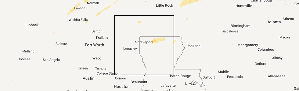
Number of Impacted Households on 2/24/2011
0
Impacted by 1" or Larger Hail
0
Impacted by 1.75" or Larger Hail
0
Impacted by 2.5" or Larger Hail
Square Miles of Populated Area Impacted on 2/24/2011
0
Impacted by 1" or Larger Hail
0
Impacted by 1.75" or Larger Hail
0
Impacted by 2.5" or Larger Hail


Cities Most Affected by Hail Storms of 2/24/2011
| Hail Size | Demographics of Zip Codes Affected | ||||||
|---|---|---|---|---|---|---|---|
| City | Count | Average | Largest | Pop Density | House Value | Income | Age |
Hail and Wind Damage Spotted on 2/24/2011
Filter by Report Type:Hail ReportsWind Reports
States Impacted
Tennessee, Arkansas, Louisiana, Missouri, Kentucky, Mississippi, Alabama, Georgia, North CarolinaTennessee
| Local Time | Report Details |
|---|---|
| 2:29 PM UTC | House struck by lightning around 430 am. house located on butt road in north central sumner co. reported by em mg in sumner county TN, 40 miles NE of Nashville, TN |
| 12:30 AM UTC | Trees down on glass road and south bluff road in obion county TN, 35.6 miles NW of Mc Kenzie, TN |
| 12:39 AM UTC | Trees down in the town of glas in obion county TN, 40.7 miles WNW of Mc Kenzie, TN |
| 12:50 AM UTC | Power poles and several trees down in the cornell street and frayser boulevard are in shelby county TN, 6.6 miles NE of Memphis, TN |
| 1:00 AM UTC | Power lines down...street light bent at hwy 64 and hwy 70 in shelby county TN, 12.8 miles ENE of Memphis, TN |
| 1:05 AM UTC | Damaging straight line winds moved through east central and northeast lauderdale county. this is the same storm that produced damage across poinsett and mississippi cou in lauderdale county TN, 50.7 miles NE of Memphis, TN |
| 1:05 AM UTC | 16 foot section of backyard fence blown down. 4x4 fence uprights snapped off at ground level with two 8 foot wide sections of fence airborne for 30 feet. estimated at 7 in shelby county TN, 13.6 miles ENE of Memphis, TN |
| 1:05 AM UTC | High winds blew off top of chimney near hickory hill in shelby county TN, 11 miles ESE of Memphis, TN |
| 1:10 AM UTC | Stoplight damaged at poplar avenue and germantown roa in shelby county TN, 15.2 miles ESE of Memphis, TN |
| 1:10 AM UTC | Few trees down in lauderdale county TN, 56.2 miles WSW of Mc Kenzie, TN |
| 1:13 AM UTC | Spotter reported power poles snapped along hwy 209. also a shop destroyed and a home severely damaged along lawrence roa in lauderdale county TN, 53.3 miles WSW of Mc Kenzie, TN |
| 1:14 AM UTC | Large tree down across the road on state route 118 in weakley county TN, 25.6 miles NNW of Mc Kenzie, TN |
| 1:15 AM UTC | Powerlines down near old tupperware building on hwy 88 in lauderdale county TN, 53.8 miles WSW of Mc Kenzie, TN |
| 1:15 AM UTC | Powerlines down...poles have been snapped along highway 209 between the towns of halls and gates. some structural damage also reporte in lauderdale county TN, 52.5 miles WSW of Mc Kenzie, TN |
| 1:15 AM UTC | 100 mph wind estimate in chester county TN, 48.3 miles S of Mc Kenzie, TN |
| 1:15 AM UTC | Powerlines down near the intersection of montgomery and navy. also a tree down on a mobile home in the shady oaks subdivisio in shelby county TN, 15.3 miles NE of Memphis, TN |
| 1:15 AM UTC | Powerlines down near the intersection of montgomery and navy. trees and powerlines also down along navy road near hornet road. also a tree down on a mobile home in the in shelby county TN, 15.3 miles NE of Memphis, TN |
| 1:25 AM UTC | Trees down on a car near the intersection of mudville road and rosemark roa in shelby county TN, 22.4 miles NE of Memphis, TN |
| 1:30 AM UTC | Trees and power lines down countywid in crockett county TN, 41.5 miles SW of Mc Kenzie, TN |
| 1:30 AM UTC | A few trees and powerlines down across the northern part of fayette count in fayette county TN, 41 miles ENE of Memphis, TN |
| 1:40 AM UTC | Powerlines down near old tupperware building on hwy 88 in lauderdale county TN, 53.8 miles WSW of Mc Kenzie, TN |
| 1:40 AM UTC | Few trees down in lauderdale county TN, 56.2 miles WSW of Mc Kenzie, TN |
| 1:40 AM UTC | Straight line winds destroyed a shed on newcastle drive near armour driv in fayette county TN, 46.2 miles E of Memphis, TN |
| 1:41 AM UTC | Winds of 70 mph with small tree limbs down. penny size hail was also reported. loose patio furniture along with trash cans blown abou in gibson county TN, 26.1 miles WSW of Mc Kenzie, TN |
| 1:41 AM UTC | Winds of 70 mph with small tree limbs down. penny size hail was also reported. loose patio furniture along with trash cans blown abou in gibson county TN, 26.1 miles WSW of Mc Kenzie, TN |
| 1:50 AM UTC | Large tree branches down in yard in gibson county TN, 18 miles WSW of Mc Kenzie, TN |
| 1:51 AM UTC | Storm damage reported in madison county TN, 38.8 miles SSW of Mc Kenzie, TN |
| 2:00 AM UTC | Storm damage reported in chester county TN, 48.3 miles S of Mc Kenzie, TN |
| 2:05 AM UTC | Winds at least 80 mph. a large oak tree fell on a carport and portion of a house. carport is a total loss as well as the car inside. slight roof and siding damage susta in madison county TN, 38.8 miles SSW of Mc Kenzie, TN |
| 2:05 AM UTC | Winds at least 80 mph. a large oak tree fell on a carport and portion of a house. carport is a total loss as well as the car inside. slight roof and siding damage susta in madison county TN, 38.8 miles SSW of Mc Kenzie, TN |
| 2:07 AM UTC | Measured with a weather station in chester county TN, 48.3 miles S of Mc Kenzie, TN |
| 2:10 AM UTC | Trees down and small limbs on roads in carroll county TN, 10.5 miles SE of Mc Kenzie, TN |
| 2:10 AM UTC | Trees down at tate loop road off highway 70 southwest of huntingdon. power lines were also dow in carroll county TN, 11.7 miles SSE of Mc Kenzie, TN |
| 2:15 AM UTC | 100 mph wind estimate in chester county TN, 48.3 miles S of Mc Kenzie, TN |
| 2:15 AM UTC | 100 mph wind estimate in chester county TN, 48.3 miles S of Mc Kenzie, TN |
| 2:15 AM UTC | Trees down just west of henderson near chickasaw...also at sand road to wilson school roa in chester county TN, 48.3 miles S of Mc Kenzie, TN |
| 2:23 AM UTC | Trees were knocked down on corinth road northwest of darden. a carport was caved in damaging a pickup truck and a shed was destroyed. a tree landed on a house and a roo in henderson county TN, 35.5 miles SSE of Mc Kenzie, TN |
| 2:30 AM UTC | Tree damage was found along east antioch road and in the russwood shores area near kentucky lake. one tree fell onto a home cuasing substantial damage. other homes rece in henry county TN, 29.4 miles NE of Mc Kenzie, TN |
| 2:30 AM UTC | 15 houses damaged...with 3 houses having significant damage due to trees falling on them. a mobile home had a roof blown off. this damage was near joy road near kentuck in henry county TN, 29.4 miles NE of Mc Kenzie, TN |
| 2:50 AM UTC | 1 large tree across road on dolphin street in decatur county TN, 40.1 miles SE of Mc Kenzie, TN |
| 2:50 AM UTC | 6 to 7 homes da in decatur county TN, 40.1 miles SE of Mc Kenzie, TN |
| 2:52 AM UTC | Trees down and small limbs on roads in carroll county TN, 10.5 miles SE of Mc Kenzie, TN |
| 2:54 AM UTC | Very heavy rain in stewart county TN, 44.9 miles ENE of Mc Kenzie, TN |
| 2:54 AM UTC | Storm damage reported in stewart county TN, 44.9 miles ENE of Mc Kenzie, TN |
| 3:10 AM UTC | Trees across west crab creek road. hwy100/spotlight road...transformer blown off pool. power outage in dickson county TN, 34.2 miles W of Nashville, TN |
| 3:15 AM UTC | Power outages in williamson county TN, 11.6 miles S of Nashville, TN |
| 3:15 AM UTC | Farmers co-op had roof damage. other minor structure damage included gutters torn off houses. trees were blown dow in hickman county TN, 45.8 miles SW of Nashville, TN |
| 3:15 AM UTC | Accident i-40...wind related. mile marker 16 in dickson county TN, 34.2 miles W of Nashville, TN |
| 3:15 AM UTC | Harmon springs - tree in house in dickson county TN, 34.2 miles W of Nashville, TN |
| 3:15 AM UTC | Several trees down and other debris along a miles-long stretch of highway 100 in williamson county TN, 23.1 miles SW of Nashville, TN |
| 3:15 AM UTC | Several trees down in williamson county TN, 24.3 miles SW of Nashville, TN |
| 3:15 AM UTC | Roof blown off near woodlawn in montgomery county TN, 43.5 miles NW of Nashville, TN |
| 3:15 AM UTC | Several large trees down near exit 8 off of i-24 in montgomery county TN, 36.6 miles NW of Nashville, TN |
| 3:17 AM UTC | Storm damage reported in montgomery county TN, 36.6 miles NW of Nashville, TN |
| 3:20 AM UTC | Trees and power lines down countywid in crockett county TN, 41.5 miles SW of Mc Kenzie, TN |
| 3:20 AM UTC | Multiple power lines down along lebanon rd. power outages to area neighborhood in davidson county TN, 4.4 miles E of Nashville, TN |
| 3:41 AM UTC | Trees down crab creek road. hwy100...transformer blown off poll. power outage in dickson county TN, 34.2 miles W of Nashville, TN |
| 3:50 AM UTC | Hwy100/yellow creek road...numerous large trees dow in dickson county TN, 34.2 miles W of Nashville, TN |
| 3:58 AM UTC | Tree down on house on petway avenue in east nashville in davidson county TN, 0.2 miles NNW of Nashville, TN |
| 3:58 AM UTC | 4 inch tree down and estimated 65 mph winds in davidson county TN, 9.4 miles E of Nashville, TN |
| 3:58 AM UTC | Trees down near edmonson and macmurry and near harding in davidson county TN, 2.7 miles NE of Nashville, TN |
| 4:00 AM UTC | In the carriage hills subdivision near ravenwood school fences were blown in williamson county TN, 15 miles S of Nashville, TN |
| 4:06 AM UTC | Trees down across jfk drive in rutherford county TN, 16.4 miles SE of Nashville, TN |
| 4:21 AM UTC | Numerous tree down and power outages. water reported over highway 12 in stewart county TN, 44.9 miles ENE of Mc Kenzie, TN |
| 4:25 AM UTC | Trained spotter measured 80mph wind gust with home weather statio in de kalb county TN, 55.5 miles ESE of Nashville, TN |
| 4:25 AM UTC | About 30 homes damaged by fallen trees across davidson county reported by police and fire officials. hardest hit area is near percy priest lak in davidson county TN, 0.2 miles NNW of Nashville, TN |
| 4:25 AM UTC | Large pine tree down and blocking one lane of shute lan in davidson county TN, 9.6 miles NE of Nashville, TN |
| 4:25 AM UTC | At bridgestone warehouse guard shack blown over with man i in wilson county TN, 24.5 miles E of Nashville, TN |
| 4:31 AM UTC | Trees da in davidson county TN, 9.7 miles ENE of Nashville, TN |
| 4:31 AM UTC | Tree reported on house near indian lake in sumner county TN, 12.8 miles NE of Nashville, TN |
| 4:50 AM UTC | Storm damage reported in de kalb county TN, 55.5 miles ESE of Nashville, TN |
| 5:00 AM UTC | Trees blown over into roads. rpt from highway dep in de kalb county TN, 55.5 miles ESE of Nashville, TN |
| 5:25 AM UTC | Trees down on shelbyville hwy. power outages reported in vann town are in lincoln county TN, 68 miles ENE of Florence, AL |
| 5:29 AM UTC | Trees down on marbury in coffee county TN, 56.1 miles WNW of Chattanooga, TN |
| 5:30 AM UTC | Structural damage reported by public. no other detail in overton county TN, 82.6 miles WNW of Knoxville, TN |
| 5:34 AM UTC | Trees down on highway 70 at sand springs just west of monterey in putnam county TN, 74.8 miles W of Knoxville, TN |
| 5:35 AM UTC | Reported trees down on lewisburg hwy. damage reported to fayetteville public utilitie in lincoln county TN, 64.7 miles S of Nashville, TN |
| 5:35 AM UTC | Reported trees down on lewisburg hw in lincoln county TN, 64.7 miles S of Nashville, TN |
| 6:00 AM UTC | Four trees down in and around dunlap. reported by dispatc in sequatchie county TN, 22.8 miles NNW of Chattanooga, TN |
| 6:08 AM UTC | Trees down. event occurred between 1201am and 1216 am. no location give in cumberland county TN, 62.7 miles W of Knoxville, TN |
| 6:15 AM UTC | Few trees dow in morgan county TN, 38.7 miles WNW of Knoxville, TN |
| 6:30 AM UTC | Two trees down and numerous power outages in dayton. reorted by dispatc in rhea county TN, 35 miles NNE of Chattanooga, TN |
| 6:30 AM UTC | Few trees down on whitwell mountai in marion county TN, 15.9 miles NW of Chattanooga, TN |
| 6:42 AM UTC | Two trees down in harriman. one tree down in rockwood. one tree down in oliver springs. reported by dispatc in roane county TN, 35.9 miles W of Knoxville, TN |
| 6:45 AM UTC | Several trees and numerous power lines down in and around chattanooga. reported by dispatc in hamilton county TN, 3.2 miles ENE of Chattanooga, TN |
| 7:00 AM UTC | Several trees dow in rhea county TN, 35 miles NNE of Chattanooga, TN |
| 7:00 AM UTC | Few trees dow in meigs county TN, 44.4 miles NE of Chattanooga, TN |
| 7:12 AM UTC | Five trees and two power lines down in and around knoxville. reported by dispatch in knox county TN, 1.8 miles WNW of Knoxville, TN |
| 7:15 AM UTC | Several trees dow in bradley county TN, 26.5 miles ENE of Chattanooga, TN |
| 7:15 AM UTC | Several trees down and a small carport blown over on conner driv in knox county TN, 7.1 miles NNW of Knoxville, TN |
| 7:30 AM UTC | Few trees dow in polk county TN, 38.5 miles ENE of Chattanooga, TN |
| 7:30 AM UTC | Numerous trees dow in monroe county TN, 39.1 miles SW of Knoxville, TN |
| 7:30 AM UTC | Numerous trees dow in monroe county TN, 39.6 miles SW of Knoxville, TN |
| 7:30 AM UTC | Few trees down along route 30 in mcminn county TN, 50.2 miles SW of Knoxville, TN |
| 7:45 AM UTC | Numerous trees dow in sevier county TN, 19.7 miles ESE of Knoxville, TN |
| 7:50 AM UTC | Several trees down along cnty rd 500 in mcminn county TN, 51.3 miles SW of Knoxville, TN |
Arkansas
| Local Time | Report Details |
|---|---|
| 9:45 PM UTC | Mobile home lost a roof in bismarc in hot spring county AR, 46.5 miles NE of Nashville, AR |
| 9:50 PM UTC | Trees and power lines were reported down around hot springs and also the northern part of the count in garland county AR, 47.7 miles WSW of Little Rock, AR |
| 9:55 PM UTC | Numerous trees were blown down. a fence was blown down as well. the report is from the alum fork cooperative observing statio in saline county AR, 30 miles W of Little Rock, AR |
| 9:55 PM UTC | *** 1 inj *** a couple of large trees were downed...with one tree on a house. a woman was injured at the house. a metal roof was peeled back at a nearby lumber yar in garland county AR, 45.1 miles WSW of Little Rock, AR |
| 10:00 PM UTC | Numerous trees down around bauxit in saline county AR, 19.5 miles SW of Little Rock, AR |
| 10:00 PM UTC | Trees down on highway in saline county AR, 27.1 miles W of Little Rock, AR |
| 10:00 PM UTC | Trees were reported down in the eastern part of perry county near williams junctio in perry county AR, 29.6 miles WNW of Little Rock, AR |
| 10:05 PM UTC | Trees and power lines were downed near the saline county line...or around lonsdal in garland county AR, 33.7 miles WSW of Little Rock, AR |
| 10:05 PM UTC | Trees were blown down near highway 5 and owensville cutoff road. several trees fell on the arkansas forestry commission building near the intersectio in saline county AR, 32.3 miles WSW of Little Rock, AR |
| 10:26 PM UTC | Numerous trees down around bauxit in saline county AR, 19.5 miles SW of Little Rock, AR |
| 10:45 PM UTC | A tree was reported down on interstate 530 at u.s. highway 6 in pulaski county AR, 9.6 miles S of Little Rock, AR |
| 10:47 PM UTC | A roof was partially torn off of a hous in pulaski county AR, 9.4 miles ESE of Little Rock, AR |
| 10:50 PM UTC | Numerous trees were reported dow in pulaski county AR, 10.5 miles ESE of Little Rock, AR |
| 10:56 PM UTC | Telephone pole snapped on highway 13 near mcrae in white county AR, 35.9 miles NE of Little Rock, AR |
| 11:04 PM UTC | Widespread trees and powerlines down across town. reports of roof torn off arsenal. indications are that the damage was caused by an ef1 tornado. the survey is still on in lonoke county AR, 21.5 miles E of Little Rock, AR |
| 11:04 PM UTC | Widespread trees and powerlines down across town. reports of roof torn off arsena in lonoke county AR, 21.5 miles E of Little Rock, AR |
| 11:10 PM UTC | Power lines were down...with power outages in tow in lonoke county AR, 30 miles E of Little Rock, AR |
| 11:15 PM UTC | Trees down across highway 79 sout in columbia county AR, 57.5 miles NNE of Shreveport, LA |
| 11:20 PM UTC | Thunderstorm wind gusts were estimated at 60 to 70 mph near haze in prairie county AR, 40.2 miles E of Little Rock, AR |
| 11:32 PM UTC | Power lines down at the carlisle exit of interstate 40. wind damage may be from a possible tornad in lonoke county AR, 21.7 miles ENE of Little Rock, AR |
| 11:35 PM UTC | Trees down across highway 82 at the columbia and union county line in columbia county AR, 68.9 miles SE of Nashville, AR |
| 11:35 PM UTC | Trees down across highway 82 at the columbia and union county line in columbia county AR, 68.9 miles SE of Nashville, AR |
| 11:45 PM UTC | *** 1 inj *** trees...power lines and power poles were blown down. a few trees were blown down on houses and carports. many roofs were damaged due to shingles being blo in monroe county AR, 62.3 miles E of Little Rock, AR |
| 11:45 PM UTC | Trees were downed and a roof was removed from a house at brinkley. two 18 wheelers were overtuned on interstate 40 just northeast of tow in monroe county AR, 62.3 miles E of Little Rock, AR |
| 11:50 PM UTC | Widespread trees and powerlines downed across union county in union county AR, 52.9 miles NW of Bastrop, LA |
| 11:50 PM UTC | 30 foot tall tree blown over...top of a pine tree missing...power out in st. francis county AR, 62.2 miles WSW of Memphis, TN |
| 11:50 PM UTC | 30 foot tall tree blown over...top of a pine tree missing...power out near the intersection of state route 78 and us-70 in st. francis county AR, 62.2 miles WSW of Memphis, TN |
| 12:00 AM UTC | Home with tree branches in roof in st. francis county AR, 43.9 miles W of Memphis, TN |
| 12:00 AM UTC | Home with tree branches through the roof in st. francis county AR, 43.9 miles W of Memphis, TN |
| 12:00 AM UTC | Home with tree limbs in roof in st. francis county AR, 43.9 miles W of Memphis, TN |
| 12:00 AM UTC | Home wih tree branches in roof in st. francis county AR, 43.1 miles WSW of Memphis, TN |
| 12:00 AM UTC | Home wih tree limbs in roof in st. francis county AR, 43.1 miles WSW of Memphis, TN |
| 12:00 AM UTC | Home with tree branches through the roof in st. francis county AR, 43.1 miles WSW of Memphis, TN |
| 12:00 AM UTC | Home with tree branches in roof in st. francis county AR, 39.6 miles WSW of Memphis, TN |
| 12:00 AM UTC | Home with tree branches through the roof in st. francis county AR, 39.6 miles WSW of Memphis, TN |
| 12:00 AM UTC | Home with tree limbs in roof in st. francis county AR, 39.6 miles WSW of Memphis, TN |
| 12:05 AM UTC | Damaging straight line winds moved through eastern poinsett and western mississippi counties and the cities of mccormick...marked tree...lepanto...and west ridge betwee in poinsett county AR, 43.2 miles NW of Memphis, TN |
| 12:13 AM UTC | Roof taken off of a building in marked tree in poinsett county AR, 33.6 miles NW of Memphis, TN |
| 12:13 AM UTC | Roof taken off of a building in wheatley in poinsett county AR, 33.6 miles NW of Memphis, TN |
| 12:15 AM UTC | Power poles down in st. francis county AR, 43.1 miles WSW of Memphis, TN |
| 12:20 AM UTC | Powerlines and a tree down on a house...people are trapped insid in poinsett county AR, 35.5 miles NNW of Memphis, TN |
| 12:20 AM UTC | Trees and signs were blown down in tow in lincoln county AR, 61 miles SSE of Little Rock, AR |
| 12:20 AM UTC | 18 wheeler blown over on its side on hwy 63 near tulo in poinsett county AR, 40.9 miles NW of Memphis, TN |
| 12:25 AM UTC | Powerlines down in etowa in mississippi county AR, 41.3 miles NNW of Memphis, TN |
| 12:25 AM UTC | Barn destroyed and gin damaged. tin scattered over wide area. one tree snapped and another tree uprooted. well pivots turned over about 5 miles north of west ridg in mississippi county AR, 38.5 miles NNW of Memphis, TN |
| 12:29 AM UTC | Tractor trailer blown over on interstate 55 at mile marker 2 in crittenden county AR, 19.8 miles NNW of Memphis, TN |
| 12:29 AM UTC | Tractor trailer blown over on interstate 55 at mile marker 2 in poinsett county AR, 44.1 miles NW of Memphis, TN |
| 12:30 AM UTC | Damaging straight line winds moved through eastern crittenden and northern shelby county. tree...power line...and some minor structural damage occurred beginning in cra in crittenden county AR, 16.8 miles WNW of Memphis, TN |
| 12:35 AM UTC | Trees were downed in and around town...with power outages reporte in drew county AR, 58.5 miles N of Bastrop, LA |
| 12:38 AM UTC | Power lines down in mississippi county AR, 56 miles N of Memphis, TN |
| 12:38 AM UTC | Roof torn off a gas station in mario in crittenden county AR, 9.5 miles WNW of Memphis, TN |
| 12:40 AM UTC | Powerlines down on highway 61 and on highway 140 1 mile south of osceol in mississippi county AR, 37.4 miles N of Memphis, TN |
| 12:47 AM UTC | Measured with a handheld anemometer in mississippi county AR, 38.1 miles N of Memphis, TN |
| 1:00 AM UTC | 2 trees were blown down on power lines in dermot in chicot county AR, 58.7 miles NNE of Bastrop, LA |
| 1:00 AM UTC | Road signs were blown dow in desha county AR, 66.1 miles NNE of Bastrop, LA |
| 1:12 AM UTC | 3 trees down...cars blown off roads and power outages in wilmot. power outages also in portlan in ashley county AR, 27.9 miles NE of Bastrop, LA |
| 1:20 AM UTC | Wind gusts of 60-70 mph in chicot county AR, 47.9 miles NE of Bastrop, LA |
| 1:30 AM UTC | 2 trees blown down on houses in eudora. a car got entangled in power lines and the driver was trapped inside the vehicl in chicot county AR, 44.8 miles ENE of Bastrop, LA |
| 1:30 AM UTC | Power lines down across a car. power outages in eudora...north of lake village and in dermott likely due to strong wind in chicot county AR, 44.8 miles ENE of Bastrop, LA |
| 1:30 AM UTC | Trees and power lines were downed in the city in chicot county AR, 44.8 miles ENE of Bastrop, LA |
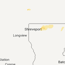
Louisiana
| Local Time | Report Details |
|---|---|
| 10:30 PM UTC | 18 wheeler overturned along hwy 1 in caddo county LA, 25.7 miles NNW of Shreveport, LA |
| 10:43 PM UTC | Trees downed at hwy 3 and lake rd in bossier county LA, 27.4 miles N of Shreveport, LA |
| 10:45 PM UTC | Tree downed on mobile home in the 1600 block of jefferson paige r in caddo county LA, 8.7 miles WSW of Shreveport, LA |
| 10:52 PM UTC | Tree downed on hwy 157 in bossier county LA, 22 miles NNE of Shreveport, LA |
| 11:00 PM UTC | *** 1 inj *** tree downed on truck in the 200 blk of n curtis...1 injured in webster county LA, 35.8 miles NNE of Shreveport, LA |
| 11:17 PM UTC | Trees downed in webster county LA, 39.6 miles NE of Shreveport, LA |
| 11:17 PM UTC | Downed powerline on hwy 164 in bossier county LA, 15.8 miles E of Shreveport, LA |
| 11:17 PM UTC | Trees downed in webster county LA, 30 miles NE of Shreveport, LA |
| 11:21 PM UTC | Gazebo and vehicle damaged...outbuilding with 5 feet of steel rods imbedded underground lifte in claiborne county LA, 43.7 miles NE of Shreveport, LA |
| 11:38 PM UTC | Trees downed along hwy 154 in bienville county LA, 24.5 miles ESE of Shreveport, LA |
| 11:47 PM UTC | Numerous trees and powerlines downed in claiborne county LA, 42.9 miles ENE of Shreveport, LA |
| 11:47 PM UTC | Trees downed in bienville county LA, 30.1 miles ESE of Shreveport, LA |
| 12:04 AM UTC | Trees downed in bienville county LA, 38.4 miles ESE of Shreveport, LA |
| 12:25 AM UTC | Widespread downed trees across the parish in lincoln county LA, 45.6 miles WSW of Bastrop, LA |
| 12:30 AM UTC | Tree downed on hwy 167 in the community of clay in lincoln county LA, 51.5 miles WSW of Bastrop, LA |
| 12:32 AM UTC | Trees down blocking highway 151 in lincoln county LA, 48.1 miles W of Bastrop, LA |
| 12:55 AM UTC | Trees down near highway 164 and 14 in jackson county LA, 39.8 miles SW of Bastrop, LA |
| 12:55 AM UTC | Trees downed in calhoun in ouachita county LA, 31.4 miles SW of Bastrop, LA |
| 12:55 AM UTC | Trees were downed in the northwestern portion of the paris in morehouse county LA, 4.9 miles N of Bastrop, LA |
| 1:00 AM UTC | Several trees downed along bonner ferry rd near bussy lake. much of the city of bastrop is without powe in morehouse county LA, 5.6 miles N of Bastrop, LA |
| 1:01 AM UTC | 60 mph winds plus in the strerlington/perryville area of extreme northern ouachita paris in ouachita county LA, 10.4 miles SW of Bastrop, LA |
| 1:03 AM UTC | Tree down on new natchitoches road west of monroe resulting in power outage in ouachita county LA, 28.6 miles SW of Bastrop, LA |
| 1:07 AM UTC | Powerlines downed in ouachita county LA, 20.8 miles SSW of Bastrop, LA |
| 1:30 AM UTC | Trees were downed and a double wide trailor was heavily damaged north of kilbourne near the arkansas state lin in west carroll county LA, 38.4 miles ENE of Bastrop, LA |
| 1:30 AM UTC | Trees were downed and a double wide trailor was heavily damaged north of kilbourne. updated...5 homes were damaged and a church roof was damaged along highway 585...nea in west carroll county LA, 38.4 miles ENE of Bastrop, LA |
| 1:30 AM UTC | Power outages reported in oak grove and kilbourne. likely from damaging wind in west carroll county LA, 31.1 miles E of Bastrop, LA |
| 1:50 AM UTC | Two trees and a power line down along hwy 65 n near shelbur in east carroll county LA, 40.5 miles E of Bastrop, LA |
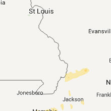
Missouri
| Local Time | Report Details |
|---|---|
| 11:40 PM UTC | Vehicles pushed off road near the intersection of i-55 and hwy a 3 miles east of wardell in pemiscot county MO, 66.7 miles S of Cape Girardeau, MO |
| 12:00 AM UTC | Peak wind 75 mph. path width 75 yards and length 300 yards. 2 well constructed barns destroyed. shingle and/or siding damage to several home in new madrid county MO, 60.3 miles S of Cape Girardeau, MO |
Kentucky
| Local Time | Report Details |
|---|---|
| 12:18 AM UTC | Peak wind 85 mph. damage area was 150 yards wide and 75 yards long. 1 grain bin destroyed. a grain bin... machinery shed...carport...vehicle and house were damaged. bar in fulton county KY, 45 miles NW of Mc Kenzie, TN |
| 12:36 AM UTC | Carport blown across lone oak road beside orileys auto. street lights out at intersection of interstate 24 and highway 6 in mccracken county KY, 51.5 miles ESE of Cape Girardeau, MO |
| 12:50 AM UTC | Late report...tree down on home in the reidland area along hwy 131/said roa in mccracken county KY, 52.4 miles ESE of Cape Girardeau, MO |
| 1:08 AM UTC | Several downed trees with wind gusts 45 to 50 mp in marshall county KY, 47 miles N of Mc Kenzie, TN |
| 1:45 AM UTC | Several trees and tree limbs down or broken. some shingles off several homes on highway 13 in trigg county KY, 63.5 miles NE of Mc Kenzie, TN |
| 1:55 AM UTC | Wind measured around the 68/80 bypass on the east side of town. measured winds 65 mph at lovers lan in christian county KY, 61.5 miles NW of Nashville, TN |
| 2:19 AM UTC | 10 power poles snapped and debris and electrical lines lying across princeton road on the northwest side of tow in christian county KY, 61.5 miles NW of Nashville, TN |
| 2:19 AM UTC | Several power poles snapped and debris and electrical lines lying across princeton road on the northwest side of tim in christian county KY, 61.5 miles NW of Nashville, TN |
| 2:30 AM UTC | Storm damage reported in muhlenberg county KY, 52.4 miles SSE of Evansville, IN |
| 2:30 AM UTC | Late report...winds estimated 60 to 65 mp in todd county KY, 61 miles NNW of Nashville, TN |
| 2:50 AM UTC | Tree down on highway 43 in logan county KY, 58.2 miles N of Nashville, TN |
| 2:50 AM UTC | A barn and shed were destroyed near the intersection of highway 431 and highway 2371. a double wide sustained some siding damage just south of thi in logan county KY, 40.3 miles N of Nashville, TN |
| 2:56 AM UTC | Butler county department of highways reported trees across al emery road and brooklyn chapel road near brookly in butler county KY, 66.1 miles SW of Louisville, KY |
| 2:59 AM UTC | Several trees upr in christian county KY, 63.9 miles S of Evansville, IN |
| 3:00 AM UTC | Concentrated straight-line wind damage occurred 5 miles west of crofton along the consolation loop and hwy 800. peak wind 85 mph. path width 3/4 of a mile and length 2 in christian county KY, 63.9 miles S of Evansville, IN |
| 3:17 AM UTC | Power outages on the n side of leitchfield for about an hour due to t-storm winds in grayson county KY, 47 miles SW of Louisville, KY |
| 3:35 AM UTC | A double wide was damaged near oakville. an adult female was trapped inside. the extent of any injuries is unknown at this tim in logan county KY, 40.7 miles N of Nashville, TN |
| 3:42 AM UTC | 60 mph gust measured at wky met lab. sustained 45 mp in warren county KY, 61.9 miles NNE of Nashville, TN |
| 3:50 AM UTC | Power outages in western williamson county in simpson county KY, 40.6 miles NNE of Nashville, TN |
| 4:00 AM UTC | Cinder block wall of a car wash was blown i in warren county KY, 58.4 miles NNE of Nashville, TN |
| 4:00 AM UTC | Barn roof damage on parkers grove road in larue county KY, 37.1 miles S of Louisville, KY |
| 4:00 AM UTC | Barn roof damage near charlie ragland road and us 31e in larue county KY, 36.4 miles S of Louisville, KY |
| 4:10 AM UTC | Tree down across highway 10 in simpson county KY, 42.4 miles NNE of Nashville, TN |
| 4:15 AM UTC | Two barns were destroyed near railto in barren county KY, 68.6 miles NNE of Nashville, TN |
| 4:15 AM UTC | Trees down in western parts of barren count in barren county KY, 68.7 miles NE of Nashville, TN |
| 4:20 AM UTC | A garage was damaged on littrell roa in barren county KY, 66.9 miles NNE of Nashville, TN |
| 4:55 AM UTC | Tree down blocking state highway 2784 near ky 70 in taylor county KY, 50.9 miles SSE of Louisville, KY |
| 4:58 AM UTC | Large trees down on battlefield road in the park. some of the trees are up to 22 inches in diamete in boyle county KY, 48 miles ESE of Louisville, KY |
| 5:00 AM UTC | Tree dow in adair county KY, 65.2 miles SSE of Louisville, KY |
| 5:00 AM UTC | Trees were downed across main roadways in and near columbi in adair county KY, 65.2 miles SSE of Louisville, KY |
| 5:07 AM UTC | Trees were downed on highway 33 near the mercer county lin in boyle county KY, 43.6 miles W of Irvine, KY |
| 5:23 AM UTC | Extremely heavy rains...sustained high winds with stronger gust in casey county KY, 57.4 miles SW of Irvine, KY |
| 5:35 AM UTC | Nashville tn wfo conducted a storm survey in pickett county tn and clinton county ky. the survey found that a microburst produced straight line winds of 80 mph and dama in clinton county KY, 77.7 miles NW of Knoxville, TN |
| 5:35 AM UTC | Nashville tn wfo conducted a storm survey in pickett county tn and clinton county ky. the survey found that a microburst produced straight line winds of 80 mph and dama in clinton county KY, 82.2 miles NW of Knoxville, TN |
| 5:50 AM UTC | A screen door was torn from a home along hwy 92e in monticello. a number of power outages were also reported in and around monticello. multiple trees had been blown dow in wayne county KY, 76.4 miles SW of Irvine, KY |
| 6:10 AM UTC | A tree fell on a carport damaging both carport and boat being housed inside the carport. another tree also fell on a building at another site in keavy and damaged that in laurel county KY, 49.5 miles SSW of Irvine, KY |
| 6:10 AM UTC | Some small trees were blown down along hwy 92e near monticell in whitley county KY, 55.5 miles NNW of Knoxville, TN |
| 6:53 AM UTC | Estimated 58 mph wind gust in ne in perry county KY, 44.4 miles ESE of Irvine, KY |
| 6:55 AM UTC | One tree down on brown creek road near 451 and hal rogers parkway at mile marker 5 in perry county KY, 50.5 miles SE of Irvine, KY |
Mississippi
| Local Time | Report Details |
|---|---|
| 1:27 AM UTC | Part of the roof blown off a casino near the mississippi river bridges. several light poles also blown down in the parking lo in washington county MS, 60.3 miles NE of Bastrop, LA |
| 1:30 AM UTC | Estimated wind gust associated with the roof dmg to the casino outside greenvill in washington county MS, 60.3 miles NE of Bastrop, LA |
| 1:30 AM UTC | Trees downed...some blocking roads...and roofs damaged in the city of cleveland in bolivar county MS, 95.4 miles NE of Bastrop, LA |
| 1:38 AM UTC | Carport blown off of a mobile home and onto two nearby parked cars in washington county MS, 59.1 miles ENE of Bastrop, LA |
| 1:40 AM UTC | Around a dozen power poles were downed by high winds. several power outages in the area around the state penitentiar in sunflower county MS, 91.9 miles SSW of Memphis, TN |
| 1:44 AM UTC | Estimated wind gust associated with the dozen downed power pole in sunflower county MS, 91.9 miles SSW of Memphis, TN |
| 1:50 AM UTC | Tree limbs down and tin roofs off some structures in issaquena county MS, 57.6 miles ENE of Bastrop, LA |
| 1:50 AM UTC | Trees and power lines knocked down in washington county MS, 67.5 miles ENE of Bastrop, LA |
| 1:50 AM UTC | Trees and power poles dow in sunflower county MS, 83.7 miles NNW of Jackson, MS |
| 1:51 AM UTC | Limbs and mailboxes blown over...car blown over near beaver lak in itawamba county MS, 50.5 miles SW of Florence, AL |
| 2:00 AM UTC | Trees were downed around nitta yuma in sharkey county MS, 63.2 miles NW of Jackson, MS |
| 2:15 AM UTC | Power outage reported in greenwood. likely from damaging wind in leflore county MS, 79.6 miles W of Starkville, MS |
| 2:15 AM UTC | Two homes were damaged in itta bena...one sustained roof damage...and the other sustained window damag in leflore county MS, 83.2 miles N of Jackson, MS |
| 2:15 AM UTC | Several large trees as well as power lines downed in the area. a couple homes were da in leflore county MS, 83.1 miles N of Jackson, MS |
| 2:15 AM UTC | Trees and power lines were downed along pluck rd in humphreys county MS, 62.9 miles NNW of Jackson, MS |
| 2:15 AM UTC | Two trees were downed between greenwood and itta bena in leflore county MS, 84.2 miles W of Starkville, MS |
| 2:16 AM UTC | Trees down in leflore county MS, 79.6 miles W of Starkville, MS |
| 2:20 AM UTC | A large fence was blown down at an industrial park near greenwood in leflore county MS, 79.6 miles W of Starkville, MS |
| 2:20 AM UTC | Trees were blown down in the northern part of the county. a large tree was downed across a road in mone in leflore county MS, 81.6 miles W of Starkville, MS |
| 2:30 AM UTC | Recorded at grenada municipal airport in grenada county MS, 62.2 miles WNW of Starkville, MS |
| 2:30 AM UTC | Several trees down in multiple locations in grenada county MS, 61.4 miles WNW of Starkville, MS |
| 2:35 AM UTC | Numerous trees down around carrollton...some trees blocking roads in carroll county MS, 64 miles W of Starkville, MS |
| 2:40 AM UTC | Several trees and power lines downed across yazoo county. some trees were blocking roadways. some minor tree fires were reported as a result of damaged utility lines. s in yazoo county MS, 40.9 miles NNW of Jackson, MS |
| 2:50 AM UTC | Trees were reported down in the city of lexington...including one tree blocking highway 17 n in holmes county MS, 57.1 miles N of Jackson, MS |
| 3:00 AM UTC | Trees and power lines were downed across all of montgomery county in montgomery county MS, 43.8 miles W of Starkville, MS |
| 3:10 AM UTC | Trees were downed across webster county. one tree fell across highway 9 near walthall...and a car accident resulted. numerous power outages countywid in webster county MS, 28.7 miles WNW of Starkville, MS |
| 3:15 AM UTC | Several large trees down...some on cars around new harmony and blue springs in union county MS, 64.7 miles N of Starkville, MS |
| 3:20 AM UTC | A few trees were downed across attala count in attala county MS, 53 miles WSW of Starkville, MS |
| 3:25 AM UTC | Storm damage reported in lee county MS, 54.9 miles N of Starkville, MS |
| 3:25 AM UTC | Trees and power lines down countywid in pontotoc county MS, 55.2 miles NNW of Starkville, MS |
| 3:25 AM UTC | Trees...powerlines and power poles down in lee county MS, 54.9 miles N of Starkville, MS |
| 3:25 AM UTC | Trees down along highway 341 and county road 10 in calhoun county MS, 35.5 miles NW of Starkville, MS |
| 3:25 AM UTC | A couple trees were downed...partially blocking dewees rd. time estimate in madison county MS, 16 miles N of Jackson, MS |
| 3:30 AM UTC | Trees down across parts of choctaw county in choctaw county MS, 23.3 miles WSW of Starkville, MS |
| 3:30 AM UTC | Trees were downed along highway 407...highway 790...and highway 9 across choctaw count in choctaw county MS, 23.3 miles WSW of Starkville, MS |
| 3:30 AM UTC | Several trees were blown dow in clay county MS, 19.2 miles NNW of Starkville, MS |
| 3:32 AM UTC | Roof peeled back on a business near the intersection of north port road and hwy 7 in pontotoc county MS, 55.2 miles NNW of Starkville, MS |
| 3:32 AM UTC | Several trees down in saltillo...possible tornad in lee county MS, 63.4 miles N of Starkville, MS |
| 3:35 AM UTC | Trees down in northwestern and western leake county in leake county MS, 49 miles NE of Jackson, MS |
| 3:38 AM UTC | Trees/power lines down in new wren...cason...smithville. 3 mobile homes with some damag in monroe county MS, 36.8 miles NNE of Starkville, MS |
| 3:44 AM UTC | A few trees down and a fence blown dow in oktibbeha county MS, 3.7 miles SW of Starkville, MS |
| 3:50 AM UTC | Several trees down across belmont in tishomingo county MS, 36.4 miles WSW of Florence, AL |
| 3:50 AM UTC | Lewisburg and match hatcher trees down in desoto county MS, 23.2 miles SE of Memphis, TN |
| 3:50 AM UTC | Utility lines along old fannin rd were damaged by large tree limbs. time estimate in rankin county MS, 9.1 miles ENE of Jackson, MS |
| 3:51 AM UTC | Limbs and mailboxes blown over...car blown over near beaver lak in itawamba county MS, 50.5 miles SW of Florence, AL |
| 3:52 AM UTC | Trees...powerlines and power poles down in lee county MS, 54.9 miles N of Starkville, MS |
| 3:53 AM UTC | Trees and power lines down all over tow in clay county MS, 14.1 miles NE of Starkville, MS |
| 3:55 AM UTC | Trees and powerlines down on jasper street in rankin county MS, 10.6 miles E of Jackson, MS |
| 3:57 AM UTC | Several trees blown dow in clay county MS, 11.4 miles ENE of Starkville, MS |
| 4:03 AM UTC | A couple trees were blown dow in winston county MS, 35.8 miles SSW of Starkville, MS |
| 4:15 AM UTC | 8 trees were blown down around the city of caledoni in lowndes county MS, 31.5 miles ENE of Starkville, MS |
| 4:15 AM UTC | A tree was blown down on a house in the city of columbu in lowndes county MS, 24 miles E of Starkville, MS |
| 4:17 AM UTC | A couple trees were blown dow in winston county MS, 38.5 miles SSW of Starkville, MS |
| 5:04 AM UTC | A couple trees were blown dow in lauderdale county MS, 67.3 miles S of Starkville, MS |
| 5:18 AM UTC | A couple trees down...1 across cr 16 in jasper county MS, 56.2 miles ESE of Jackson, MS |
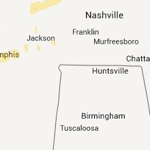
Alabama
| Local Time | Report Details |
|---|---|
| 4:05 AM UTC | Trees/power lines down on us-72 near the mississippi/alabama state lin in colbert county AL, 24.2 miles W of Florence, AL |
| 4:06 AM UTC | Damage to residence in downtown cherokee at mm08 on us-7 in colbert county AL, 17 miles W of Florence, AL |
| 4:08 AM UTC | Roof damage to two homes off cr 19 in marion county AL, 46.2 miles SSW of Florence, AL |
| 4:13 AM UTC | Power outage in oakland. estimated 60mph wind gus in lauderdale county AL, 7.6 miles WNW of Florence, AL |
| 4:15 AM UTC | Powerlines down along military street in marion county AL, 48.7 miles SSW of Florence, AL |
| 4:16 AM UTC | Up to 15 reports of thunderstorm wind damage were received within cullman county from 1116 pm through 1140 pm. numerous trees and powerlines were knocked dow in cullman county AL, 50.2 miles N of Birmingham, AL |
| 4:17 AM UTC | Roof damage to jjs restauraunt and peoples drug store on hwy 72 in cherokee. multiple power outages in b in colbert county AL, 5.2 miles SSW of Florence, AL |
| 4:17 AM UTC | Power outages in crooked oak and locust shore in colbert county AL, 10.1 miles WSW of Florence, AL |
| 4:20 AM UTC | Damage to chicken houses. tv towers twisted and blown down. possible tornad in marion county AL, 37.6 miles SSW of Florence, AL |
| 4:20 AM UTC | Two large trees down along old hackleburg r in marion county AL, 37.2 miles SSW of Florence, AL |
| 4:20 AM UTC | Reports of structural damage along al hwy 253 south of hackleburg. extent of damage unknown at this time...possible tornad in marion county AL, 39 miles SSW of Florence, AL |
| 4:21 AM UTC | Numerous trees and power lines were knocked down along portions of highway 43 between russellville and the county line northeast of hacklebur in franklin county AL, 29.4 miles S of Florence, AL |
| 4:24 AM UTC | Trees and power lines knocked down along highway 13 near the marion county lin in marion county AL, 33.8 miles S of Florence, AL |
| 4:26 AM UTC | Trees were knocked down near mile marker 7 on highway 24 in franklin county AL, 28.4 miles S of Florence, AL |
| 4:27 AM UTC | Media reports 63mph wind gust measured from alfa ca in franklin county AL, 20.3 miles S of Florence, AL |
| 4:30 AM UTC | Trees and power lines down county wid in lamar county AL, 45.3 miles ENE of Starkville, MS |
| 4:34 AM UTC | Barn blown onto highway 10 in fayette county AL, 56.7 miles ENE of Starkville, MS |
| 4:36 AM UTC | Trees dow in fayette county AL, 59 miles WNW of Birmingham, AL |
| 4:37 AM UTC | Roof blown off buildin in fayette county AL, 59.7 miles ENE of Starkville, MS |
| 4:48 AM UTC | Trees dow in winston county AL, 52.4 miles S of Florence, AL |
| 4:52 AM UTC | Power outage in phil campbel in franklin county AL, 31.1 miles S of Florence, AL |
| 4:55 AM UTC | Several trees knocked down with 5 inch diameter limbs snappe in morgan county AL, 51.2 miles ESE of Florence, AL |
| 4:59 AM UTC | Multiple trees down near hwy 7 in limestone county AL, 25.9 miles E of Florence, AL |
| 5:00 AM UTC | Trees down blocking road on hwy 18 at the fayette/walker county lin in walker county AL, 41.8 miles WNW of Birmingham, AL |
| 5:02 AM UTC | Barn damaged on duncan road between al 5 and al 19 in walker county AL, 42.8 miles NW of Birmingham, AL |
| 5:04 AM UTC | Trees were blown down on scott cemetary roa in walker county AL, 38.8 miles NW of Birmingham, AL |
| 5:05 AM UTC | Trees dow in winston county AL, 44.9 miles NNW of Birmingham, AL |
| 5:05 AM UTC | Roof off mobile home and trees down on cr 39 at al 27 in winston county AL, 49 miles NNW of Birmingham, AL |
| 5:09 AM UTC | Damage to eastside baptist church on highway 118 next to the jasper mal in walker county AL, 33.5 miles NW of Birmingham, AL |
| 5:09 AM UTC | Tree down blocking hwy 79 at dallas selfville fire departmen in blount county AL, 26.5 miles NNE of Birmingham, AL |
| 5:09 AM UTC | Trees were blown down near christy lane and gaines road near highway 257 curry highwa in walker county AL, 37.7 miles NW of Birmingham, AL |
| 5:10 AM UTC | Trees dow in walker county AL, 34.8 miles NW of Birmingham, AL |
| 5:10 AM UTC | Trees down in several locations around jaspe in walker county AL, 34.8 miles NW of Birmingham, AL |
| 5:12 AM UTC | Trees dow in walker county AL, 26.2 miles NW of Birmingham, AL |
| 5:13 AM UTC | Reports of pine and oak trees down...power poles down and skirting torn off a mobile home on garner roa in morgan county AL, 49.3 miles ESE of Florence, AL |
| 5:13 AM UTC | Windows were blown out in a mobile hom in morgan county AL, 47.7 miles SE of Florence, AL |
| 5:15 AM UTC | Tree down on residence on forrest chapel road in oakridg in morgan county AL, 45.9 miles ESE of Florence, AL |
| 5:16 AM UTC | Up to 15 reports of thunderstorm wind damage were reported throughout cullman county from 1116 pm through approximately 1140 pm. thunderstorm winds knocked numerous tre in cullman county AL, 50.2 miles N of Birmingham, AL |
| 5:18 AM UTC | Trees down on smith lake dam road near al 6 in walker county AL, 32.2 miles NNW of Birmingham, AL |
| 5:22 AM UTC | Power lines blown down in copeland ferr in walker county AL, 25.3 miles WNW of Birmingham, AL |
| 5:25 AM UTC | Tree down at the intersection of quarter mountain rd and carters gin rd. time estimated by rada in madison county AL, 55.6 miles E of Florence, AL |
| 5:25 AM UTC | Trees were knocked down at the intersection of carters gin road and quarter mountain road. time estimated by rada in madison county AL, 55.6 miles E of Florence, AL |
| 5:28 AM UTC | Winds estimated around 60 mp in tuscaloosa county AL, 49 miles WSW of Birmingham, AL |
| 5:28 AM UTC | Tree blown down on kicker road. tree blown down on new watermelon roa in tuscaloosa county AL, 49 miles WSW of Birmingham, AL |
| 5:30 AM UTC | 61 mph wind gust measured in downtown cullma in cullman county AL, 45.5 miles N of Birmingham, AL |
| 5:31 AM UTC | Trees down at flattop road and mount oliv in jefferson county AL, 16.4 miles WNW of Birmingham, AL |
| 5:39 AM UTC | Tree down on residence on forrest chapel road in oakridg in morgan county AL, 45.9 miles ESE of Florence, AL |
| 5:41 AM UTC | Tree down along n. washington stree in sumter county AL, 67.2 miles NW of Camden, AL |
| 5:41 AM UTC | Trees down on thomas loop r in jefferson county AL, 14.5 miles NNW of Birmingham, AL |
| 5:43 AM UTC | Power lines were knocked down on cr 27 in dekalb county AL, 53.8 miles SSW of Chattanooga, TN |
| 5:45 AM UTC | Trees knocked down interrupting power service on coalburg road in jefferson county AL, 9.5 miles NW of Birmingham, AL |
| 5:45 AM UTC | Trees dow in sumter county AL, 68.7 miles WNW of Camden, AL |
| 5:45 AM UTC | Tree and powerlines down along minor pkwy at the high schoo in jefferson county AL, 7.6 miles WNW of Birmingham, AL |
| 5:45 AM UTC | Trees down on forest bend roa in jefferson county AL, 7.9 miles NW of Birmingham, AL |
| 5:45 AM UTC | Trees down on forest bend road in brooksid in jefferson county AL, 7.9 miles NW of Birmingham, AL |
| 5:45 AM UTC | Powerlines down along hwy 11 between york and livingston in sumter county AL, 67.6 miles NW of Camden, AL |
| 5:47 AM UTC | Tree down blocking hwy 79 at dallas selfville fire departmen in blount county AL, 26.5 miles NNE of Birmingham, AL |
| 5:47 AM UTC | Powerlines down on mount view trail and co hwy 1 in blount county AL, 32.5 miles NNE of Birmingham, AL |
| 5:50 AM UTC | Tree down on residence in ara in marshall county AL, 58 miles NNE of Birmingham, AL |
| 5:50 AM UTC | Several power poles knocked dow in jefferson county AL, 10.3 miles N of Birmingham, AL |
| 5:50 AM UTC | Tree down on county road 2 in sumter county AL, 59.8 miles NW of Camden, AL |
| 5:51 AM UTC | Tree on house on pinney wood roa in jefferson county AL, 7.6 miles N of Birmingham, AL |
| 5:54 AM UTC | Tree down across co hwy in blount county AL, 32 miles NNE of Birmingham, AL |
| 5:55 AM UTC | Power outages reported in owens crossroads on hampton roa in madison county AL, 70.8 miles ESE of Florence, AL |
| 5:56 AM UTC | Mutiple power outages reported in hampton cove and owens crossroad in madison county AL, 69.2 miles E of Florence, AL |
| 5:57 AM UTC | Power pole knocked down in jefferson county AL, 13.9 miles NNE of Birmingham, AL |
| 5:58 AM UTC | Roof blown off barn in blount county AL, 32.6 miles NNE of Birmingham, AL |
| 6:03 AM UTC | Powerlines down in ruth community near ara in marshall county AL, 59.9 miles NNE of Birmingham, AL |
| 6:05 AM UTC | Trees down on storage building at the intersection of queenstown road and 2nd stre in jefferson county AL, 12.6 miles ENE of Birmingham, AL |
| 6:05 AM UTC | Trees down on storage building at the intersection of queenstown road and 2nd stree in jefferson county AL, 12.6 miles ENE of Birmingham, AL |
| 6:06 AM UTC | Major substation has been taken out in hampton cove. reports of large and long lived power flash in the area. large power outage in southeast quadrant of madison county in madison county AL, 70.4 miles E of Florence, AL |
| 6:08 AM UTC | Widespread trees and powerlines down in and around gallan in etowah county AL, 46.2 miles NE of Birmingham, AL |
| 6:13 AM UTC | Trees blown down on rocky hollow roa in etowah county AL, 48.7 miles NE of Birmingham, AL |
| 6:15 AM UTC | Several trees uprooted and damage to a shed and barn along jack flo in etowah county AL, 59.9 miles NE of Birmingham, AL |
| 6:15 AM UTC | A railroad arm was broken on oakwood avenu in madison county AL, 62.4 miles E of Florence, AL |
| 6:17 AM UTC | Powerlines down on 231 at rattlesnake hil in st. clair county AL, 33.4 miles ENE of Birmingham, AL |
| 6:22 AM UTC | Power outages reporte in marshall county AL, 58.6 miles NNE of Birmingham, AL |
| 6:25 AM UTC | Large tree down on powerlines along meighan blvd. winds est at 58 mp in etowah county AL, 57.2 miles NE of Birmingham, AL |
| 6:25 AM UTC | Several trees down along or near moody parkway in st. clair county AL, 19.3 miles ENE of Birmingham, AL |
| 6:27 AM UTC | Trees and powerlines down in and around gadsde in etowah county AL, 57.2 miles NE of Birmingham, AL |
| 6:27 AM UTC | Several trees down along and near county road 22 in st. clair county AL, 43.5 miles ENE of Birmingham, AL |
| 6:28 AM UTC | Chain link fence blown over and 14 fence poles bent along industrial roa in shelby county AL, 17.9 miles S of Birmingham, AL |
| 6:28 AM UTC | Chain link fence blown over and fence poles bent along industrial roa in shelby county AL, 17.9 miles S of Birmingham, AL |
| 6:30 AM UTC | Tree reported down on hwy 6 in dekalb county AL, 62 miles SSW of Chattanooga, TN |
| 6:30 AM UTC | Tree reported down on house in henager. no structural damage reporte in dekalb county AL, 37.7 miles SW of Chattanooga, TN |
| 6:36 AM UTC | Several trees down in st. clair county AL, 31.4 miles E of Birmingham, AL |
| 6:37 AM UTC | Tree down blocking county road 7 in cherokee county AL, 63.5 miles SSW of Chattanooga, TN |
| 6:40 AM UTC | Power outages reporte in marshall county AL, 60 miles NE of Birmingham, AL |
| 6:44 AM UTC | Tree and powerline down on hwy 117 near mentone post office. time estimated from rada in dekalb county AL, 35.9 miles SSW of Chattanooga, TN |
| 7:08 AM UTC | Storm damage reported in calhoun county AL, 58.6 miles E of Birmingham, AL |
| 7:22 AM UTC | Tree down across cheaha road in cleburne county AL, 57.9 miles E of Birmingham, AL |
| 7:25 AM UTC | Several trees down along perryman bridge rd and evans bridge rd between heflin and interstate 20 in cleburne county AL, 68.9 miles W of Atlanta, GA |
| 7:31 AM UTC | Trees down near county road in clay county AL, 47.2 miles NW of Auburn, AL |
| 7:35 AM UTC | Trees down on and near highway 49 nort in clay county AL, 53.7 miles NNW of Auburn, AL |
Georgia
| Local Time | Report Details |
|---|---|
| 6:40 AM UTC | Three trees down in wallwood area of north trento in dade county GA, 16.7 miles SW of Chattanooga, TN |
| 6:54 AM UTC | Three trees and three power lines down in the northwest part of the count in catoosa county GA, 6.6 miles SSE of Chattanooga, TN |
| 6:54 AM UTC | 3 trees down in the southern end of the count in walker county GA, 25.3 miles S of Chattanooga, TN |
| 7:00 AM UTC | One tree down on shinbone valley roa in chattooga county GA, 36.6 miles S of Chattanooga, TN |
| 7:12 AM UTC | One tree dow in floyd county GA, 54.7 miles S of Chattanooga, TN |
| 7:16 AM UTC | Bartow county roads department reported a tree down on the intersection of old alabama and iron hill road. the tree has been cleared and the roadway is ope in bartow county GA, 42.6 miles NW of Atlanta, GA |
| 7:30 AM UTC | Two trees and two power lines dow in haralson county GA, 48.7 miles WNW of Atlanta, GA |
| 7:36 AM UTC | One tree dow in whitfield county GA, 29.5 miles ESE of Chattanooga, TN |
| 7:41 AM UTC | Gilmer county 911 relayed reports of 2 downed trees in ellija in gilmer county GA, 53.1 miles ESE of Chattanooga, TN |
| 7:55 AM UTC | One tree down on high shoals roa in paulding county GA, 28.4 miles WNW of Atlanta, GA |
| 8:00 AM UTC | One tree dow in fannin county GA, 52.6 miles E of Chattanooga, TN |
| 8:02 AM UTC | Two trees and two power lines dow in carroll county GA, 41.4 miles WSW of Atlanta, GA |
| 8:07 AM UTC | Fannin county 911 relayed reports of 2 downed tree in fannin county GA, 57.1 miles ESE of Chattanooga, TN |
| 8:09 AM UTC | Pickens county emergency management reported a downed tree in ellija in pickens county GA, 49.8 miles N of Atlanta, GA |
| 8:15 AM UTC | Heard county 911 relayed a report of a downed tree on south river road in frankli in heard county GA, 51.4 miles NNE of Auburn, AL |
| 8:30 AM UTC | One power line dow in fulton county GA, 13.5 miles WSW of Atlanta, GA |
North Carolina
| Local Time | Report Details |
|---|---|
| 8:15 AM UTC | One tree down on harshaw rd and several down on us 19 in cherokee county NC, 62.2 miles S of Knoxville, TN |
Connect with Interactive Hail Maps