

Hail Map for Sunday, February 27, 2011

Number of Impacted Households on 2/27/2011
0
Impacted by 1" or Larger Hail
0
Impacted by 1.75" or Larger Hail
0
Impacted by 2.5" or Larger Hail
Square Miles of Populated Area Impacted on 2/27/2011
0
Impacted by 1" or Larger Hail
0
Impacted by 1.75" or Larger Hail
0
Impacted by 2.5" or Larger Hail


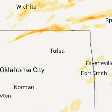


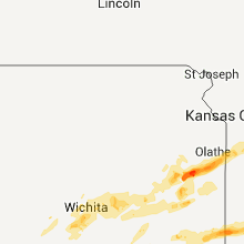


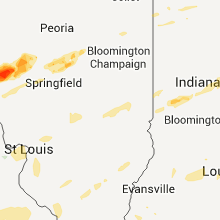


Cities Most Affected by Hail Storms of 2/27/2011
| Hail Size | Demographics of Zip Codes Affected | ||||||
|---|---|---|---|---|---|---|---|
| City | Count | Average | Largest | Pop Density | House Value | Income | Age |
| Pittsburg, KS | 2 | 1.75 | 1.75 | 179 | $58k | $27.3k | 28.1 |
| Richmond, KS | 2 | 1.75 | 1.75 | 13 | $55k | $38.1k | 42.0 |
| Buffalo, MO | 1 | 2.75 | 2.75 | 49 | $74k | $26.1k | 40.8 |
| Raymore, MO | 1 | 1.75 | 1.75 | 749 | $122k | $55.4k | 37.2 |
| Villa Ridge, MO | 1 | 1.75 | 1.75 | 172 | $121k | $44.7k | 39.5 |
| Nash, OK | 1 | 1.75 | 1.75 | 2 | $47k | $28.5k | 49.2 |
| Salem, MO | 1 | 1.75 | 1.75 | 21 | $63k | $27.0k | 42.8 |
| Gerald, MO | 1 | 1.75 | 1.75 | 37 | $82k | $40.5k | 43.3 |
| Toronto, KS | 1 | 1.75 | 1.75 | 4 | $29k | $21.2k | 55.0 |
| Paola, KS | 1 | 1.75 | 1.75 | 53 | $110k | $46.6k | 41.7 |
| Bloomington, IL | 1 | 1.75 | 1.75 | 154 | $0k | $0.0k | 36.5 |
| Rushville, IL | 1 | 1.75 | 1.75 | 30 | $58k | $35.3k | 43.1 |
| Lane, KS | 1 | 1.75 | 1.75 | 25 | $49k | $45.5k | 46.0 |
| Lebanon, MO | 1 | 1.75 | 1.75 | 73 | $75k | $30.1k | 38.8 |
Hail and Wind Damage Spotted on 2/27/2011
Filter by Report Type:Hail ReportsWind Reports
States Impacted
Missouri, Illinois, Kansas, Oklahoma, Tennessee, Texas, Indiana, Arkansas, Kentucky, OhioMissouri
| Local Time | Report Details |
|---|---|
| 4:28 PM UTC | Quarter sized hail reported near Grovespring, MO, 39.8 miles ENE of Springfield, MO |
| 10:01 PM UTC | Quarter sized hail reported near Cleveland, MO, 33.3 miles S of Kansas City, MO |
| 10:06 PM UTC | Half Dollar sized hail reported near Harrisonville, MO, 30.5 miles SSE of Kansas City, MO |
| 10:10 PM UTC | Golf Ball sized hail reported near Raymore, MO, 21.3 miles SSE of Kansas City, MO |
| 10:18 PM UTC | Quarter sized hail reported near Pleasant Hill, MO, 26.9 miles SE of Kansas City, MO |
| 10:35 PM UTC | Quarter sized hail reported near Holden, MO, 36.2 miles ESE of Kansas City, MO |
| 11:28 PM UTC | Quarter sized hail reported near Grovespring, MO, 39.8 miles ENE of Springfield, MO |
| 11:38 PM UTC | Quarter sized hail reported near Jacksonville, MO, 44.6 miles N of Columbia, MO, time estimated. |
| 11:45 PM UTC | Quarter sized hail reported near Excello, MO, 47.4 miles N of Columbia, MO, hail covering highway 63 has caused car accidents |
| 12:00 AM UTC | Wooden fence blown down and debris scattered power pole also snapped. time estimated from rada in monroe county MO, 50.7 miles NNE of Columbia, MO |
| 12:01 AM UTC | Barn blown down and trees damaged. time estimated from rada in shelby county MO, 52.5 miles NNE of Columbia, MO |
| 12:05 AM UTC | Relayed through media. blew a lawn windmill through a residence windo in randolph county MO, 30.1 miles NNW of Columbia, MO |
| 12:25 AM UTC | Possible tornado. significant roof damage to home...destruction of garage...tractor trailer and cars blown off road. time estimate in randolph county MO, 38.9 miles N of Columbia, MO |
| 12:45 AM UTC | Barn blown down and trees damaged. time corrected by spotter followup in are in shelby county MO, 52.5 miles NNE of Columbia, MO |
| 12:45 AM UTC | Several barns with roofs blown off at county road ww and highway 15. roofs also blown off 2 machine sheds and 3 grain bins blown over. multiple power poles snapped and in shelby county MO, 52 miles NNE of Columbia, MO |
| 12:45 AM UTC | Swing set blown 150 feet t to the southeast...along with damage to 4 to 5 inch limbs in monroe county MO, 50.7 miles NNE of Columbia, MO |
| 12:45 AM UTC | Wooden fence blown down and debris scattered power pole also snapped. time corrected by spotter repor in monroe county MO, 50.7 miles NNE of Columbia, MO |
| 1:35 AM UTC | Quarter sized hail reported near Mound City, MO, 80.8 miles NNW of Kansas City, MO, dime to quarter sized hail reported |
| 1:39 AM UTC | Storm damage reported in marion county MO, 50.6 miles SSE of Kahoka, MO |
| 1:40 AM UTC | Storm damage reported in marion county MO, 49.9 miles SSE of Kahoka, MO |
| 1:40 AM UTC | One plane flipped over at airport... several other planes damaged... minor structural damage to a hangar in marion county MO, 50.4 miles SSE of Kahoka, MO |
| 1:44 AM UTC | Two reports of 24-36 inch diameter trees blown down. one was across a road. officer reported that roots were pulled out of the groun in marion county MO, 52.2 miles SSE of Kahoka, MO |
| 1:45 AM UTC | 4 foot diameter tree blown down across roadway. falling tree crushed car and took down power line in marion county MO, 52.2 miles SSE of Kahoka, MO |
| 2:05 AM UTC | Smaller trees uprooted... shingles torn off house in pike county MO, 60.1 miles ENE of Columbia, MO |
| 2:52 AM UTC | Law enforcement reported roof of hog barn remove in barton county MO, 61.5 miles WNW of Springfield, MO |
| 3:21 AM UTC | Ping Pong Ball sized hail reported near Long Lane, MO, 33.4 miles NE of Springfield, MO |
| 3:25 AM UTC | Roof off of a business. report via morgan county 911. time estimate in morgan county MO, 58.4 miles SSW of Columbia, MO |
| 3:30 AM UTC | Quarter sized hail reported near Dadeville, MO, 32.4 miles NW of Springfield, MO, public report of quarter sized hail. |
| 3:47 AM UTC | Storm damage reported in ralls county MO, 48.6 miles NE of Columbia, MO |
| 3:50 AM UTC | Roof partially removed from hous in ralls county MO, 48.6 miles NE of Columbia, MO |
| 3:50 AM UTC | Roof removed from house...several barns destroyed...billboards blown down...power poles blown down...stop signs snapped in hal in ralls county MO, 48.6 miles NE of Columbia, MO |
| 3:50 AM UTC | Extensive roof damage to a home on hwy y in ralls county MO, 49.2 miles NE of Columbia, MO |
| 4:00 AM UTC | Spotter estimates winds were at least 60 mph with trees uprooted...shingles tore off of home...tin ripped from barn roofs and pea size hail 1 inch deep in pike county MO, 65.5 miles NE of Columbia, MO |
| 4:00 AM UTC | Tree damage...fence damaged in cole county MO, 27.5 miles SSE of Columbia, MO |
| 4:00 AM UTC | Law enforcement reports power polls/lines down in marys hom in miller county MO, 44.3 miles S of Columbia, MO |
| 4:05 AM UTC | Quarter sized hail reported near Frankford, MO, 65.9 miles NE of Columbia, MO |
| 4:06 AM UTC | 1 ft diameter trees knocked down...sheds damaged in pike county MO, 65.9 miles NE of Columbia, MO |
| 4:10 AM UTC | Emergency manager reported trees down and power out in half way. corrected time and event typ in polk county MO, 28.5 miles N of Springfield, MO |
| 4:15 AM UTC | Several reports of high winds with no estimated speeds...carport blew into road...pea sized hail in osage county MO, 42.1 miles SE of Columbia, MO |
| 4:15 AM UTC | Quarter sized hail reported near Windyville, MO, 43.1 miles NNE of Springfield, MO |
| 4:16 AM UTC | Quarter sized hail reported near Halfway, MO, 28.5 miles N of Springfield, MO |
| 4:16 AM UTC | Storm damage reported in pike county MO, 66.8 miles SSE of Kahoka, MO |
| 10:18 PM CST | Baseball sized hail reported near Buffalo, MO, 31.7 miles NNE of Springfield, MO, law enforcement reported baseball sized hail. |
| 4:21 AM UTC | Ping Pong Ball sized hail reported near Long Lane, MO, 33.4 miles NE of Springfield, MO, correction for time. |
| 4:25 AM UTC | Half Dollar sized hail reported near Buffalo, MO, 32.8 miles NNE of Springfield, MO |
| 4:25 AM UTC | Law enforcement reports large tree down across missouri route cc north of stockton reservoir...correction for locatio in dade county MO, 32.4 miles NW of Springfield, MO |
| 4:25 AM UTC | Law enforcement reports large tree down across missouri route cc north of stockton reservoi in dade county MO, 34.4 miles NW of Springfield, MO |
| 4:28 AM UTC | Quarter sized hail reported near Grovespring, MO, 39.8 miles ENE of Springfield, MO |
| 4:29 AM UTC | Quarter sized hail reported near Bolivar, MO, 28.4 miles NNW of Springfield, MO, also measured 40 kt wind gust. |
| 4:30 AM UTC | Storm damage reported in gasconade county MO, 49.2 miles N of Salem, MO |
| 4:30 AM UTC | Numerous trees uprooted. time estimated by rada in franklin county MO, 57.5 miles W of Saint Louis, MO |
| 4:30 AM UTC | Numerous power lines...trees and tree limbs blown down in owensville and rosebud. also...a building in owensville had its awning blown off which damaged the facad in gasconade county MO, 49.2 miles N of Salem, MO |
| 4:35 AM UTC | Quarter sized hail reported near Frankford, MO, 65.9 miles NE of Columbia, MO |
| 4:43 AM UTC | Quarter sized hail reported near Tunas, MO, 47.2 miles NNE of Springfield, MO, correction for location. |
| 10:46 PM CST | Ping Pong Ball sized hail reported near Lebanon, MO, 47.8 miles NE of Springfield, MO |
| 4:48 AM UTC | Golf Ball sized hail reported near Gerald, MO, 58.3 miles N of Salem, MO |
| 4:50 AM UTC | Tree limb blown through the side of a moble home...no injuries reporte in franklin county MO, 44.2 miles W of Saint Louis, MO |
| 4:50 AM UTC | Trees down power poles snapped in franklin county MO, 44.2 miles W of Saint Louis, MO |
| 4:53 AM UTC | Several trees fell onto houses. wires down and utility poles snappe in franklin county MO, 44.2 miles W of Saint Louis, MO |
| 4:54 AM UTC | Power lines down in franklin county MO, 55.6 miles WSW of Saint Louis, MO |
| 4:55 AM UTC | Pole barn flattened... metal roof on a garage peeled back... roof shingles blown off several houses... several trees snapped off. time approximate... 1050 to 1055 p in warren county MO, 42.8 miles W of Saint Louis, MO |
| 5:00 AM UTC | Large barn destroyed. debris thrown several hundred yard in franklin county MO, 42.4 miles W of Saint Louis, MO |
| 5:00 AM UTC | Structural damage reported at balducci vineyard in st. charles county MO, 40.2 miles W of Saint Louis, MO |
| 11:00 PM CST | Quarter sized hail reported near Buffalo, MO, 31.7 miles NNE of Springfield, MO |
| 5:00 AM UTC | Golf Ball sized hail reported near Villa Ridge, MO, 38.4 miles WSW of Saint Louis, MO |
| 11:09 PM CST | Golf Ball sized hail reported near Lebanon, MO, 43.3 miles NE of Springfield, MO |
| 5:10 AM UTC | Storm damage reported in st. louis county MO, 23.4 miles W of Saint Louis, MO |
| 5:10 AM UTC | One 4 to 5 inch diameter tree snapped off at nws st louis office. time estimated from rada in st. charles county MO, 25.2 miles WNW of Saint Louis, MO |
| 5:15 AM UTC | Storm damage reported in st. louis county MO, 21.3 miles W of Saint Louis, MO |
| 5:15 AM UTC | 3-5 inch diameter tree limbs broken...heavy lawn furniture blown into fence in st. louis county MO, 13.2 miles W of Saint Louis, MO |
| 5:15 AM UTC | Ronnies movie sign is blown down...street signs on lindburgh blown down...signs on i-270 between gravois and tesson ferrry are bent and twisted in st. louis county MO, 17 miles W of Saint Louis, MO |
| 5:15 AM UTC | Power lines down in st. charles county MO, 29.5 miles WNW of Saint Louis, MO |
| 5:15 AM UTC | Shingles removed from house...chimney blown off nearby house in st. louis county MO, 25.1 miles W of Saint Louis, MO |
| 5:22 AM UTC | Storm damage reported in st. louis county MO, 13 miles NW of Saint Louis, MO |
| 5:22 AM UTC | 70 mph winds reported at 270 and 70 with large hail of unknown size in st. louis county MO, 13.3 miles NW of Saint Louis, MO |
| 5:25 AM UTC | Storm damage reported in st. louis county MO, 19.1 miles W of Saint Louis, MO |
| 5:25 AM UTC | Trees blown down in ballwin in st. louis county MO, 19.1 miles W of Saint Louis, MO |
| 5:25 AM UTC | Big bend blvd closed in clayton due to numerous power poles dow in st. louis county MO, 7.1 miles W of Saint Louis, MO |
| 5:25 AM UTC | Numerous 4 to 5 inch diamter limbs down... est 2 foot diameter tree branch dow in st. louis county MO, 10.4 miles NNW of Saint Louis, MO |
| 5:27 AM UTC | I-44 closed in both directions between hampton and kings highway...debris in the highwa in st. louis city county MO, 2.3 miles WNW of Saint Louis, MO |
| 5:28 AM UTC | Quarter sized hail reported near Grovespring, MO, 39.8 miles ENE of Springfield, MO |
| 5:29 AM UTC | Pea sizee hail in st. louis county MO, 12.4 miles WSW of Saint Louis, MO |
| 5:30 AM UTC | On christopher dr... large older tree down partially blocking road... and a car port blown over and collapsed. this damage viewed enroute to work this mornin in st. louis county MO, 14.5 miles SSW of Saint Louis, MO |
| 5:30 AM UTC | Large pine tree 35 to 40 foot tall uprooted. also one storage shed overturne in st. louis county MO, 16.2 miles SSW of Saint Louis, MO |
| 5:40 AM UTC | Golf Ball sized hail reported near Salem, MO, 12.7 miles NW of Salem, MO |
| 7:02 AM UTC | Quarter sized hail reported near Farmington, MO, 58.7 miles NW of Cape Girardeau, MO |
| 7:15 AM UTC | Power lines down...large tree snapped...roof blown off a bar in madison county MO, 47.1 miles WNW of Cape Girardeau, MO |
| 7:31 AM UTC | Quarter sized hail reported near Perryville, MO, 34.5 miles NNW of Cape Girardeau, MO, quarter size hail reported at the county sheriffs office. |
Illinois
| Local Time | Report Details |
|---|---|
| 5:45 PM UTC | Structural damage to homes in troy in madison county IL, 18.2 miles ENE of Saint Louis, MO |
| 12:30 AM UTC | Quarter sized hail reported near Quincy, IL, 38.7 miles SSE of Kahoka, MO |
| 12:31 AM UTC | Quarter sized hail reported near Payson, IL, 45.7 miles SSE of Kahoka, MO |
| 12:35 AM UTC | Quarter sized hail reported near Payson, IL, 48.6 miles SSE of Kahoka, MO, hail covering ground |
| 12:45 AM UTC | Quarter sized hail reported near Quincy, IL, 38.7 miles SSE of Kahoka, MO |
| 12:47 AM UTC | Quarter sized hail reported near Columbus, IL, 42.3 miles SE of Kahoka, MO |
| 12:50 AM UTC | Quarter sized hail reported near Camp Point, IL, 43.2 miles SE of Kahoka, MO |
| 12:56 AM UTC | Quarter sized hail reported near Clayton, IL, 48.4 miles ESE of Kahoka, MO, covering the ground to a depth of one-2 inches |
| 1:11 AM UTC | Quarter sized hail reported near Rushville, IL, 64.2 miles ESE of Kahoka, MO |
| 1:15 AM UTC | Golf Ball sized hail reported near Rushville, IL, 56 miles WSW of Peoria, IL, golf ball size hail broke windows at a home 2 miles north of ray. |
| 2:10 AM UTC | Dozen mini storage barns scattered over one-quarter mile...on 25o north avenue between county roads 2700 and 280 in adams county IL, 58.2 miles SE of Kahoka, MO |
| 2:10 AM UTC | Mobile home shook...sucked equipment out of open garage door...blew swing set a considerable distanc in adams county IL, 59.6 miles SE of Kahoka, MO |
| 2:16 AM UTC | Quarter sized hail reported near Delavan, IL, 25.4 miles SSE of Peoria, IL, hail covering the ground on armington road 1 mile east of i-155 and still falling at 824 pm. |
| 2:20 AM UTC | Quarter sized hail reported near Mt Sterling, IL, 60.7 miles ESE of Kahoka, MO |
| 2:20 AM UTC | Storm damage reported in brown county IL, 60.7 miles ESE of Kahoka, MO |
| 2:20 AM UTC | Storm damage reported in brown county IL, 59.5 miles ESE of Kahoka, MO |
| 2:48 AM UTC | Golf Ball sized hail reported near Bloomington, IL, 32 miles ESE of Peoria, IL |
| 2:56 AM UTC | Quarter sized hail reported near , , 32.9 miles ESE of Peoria, IL |
| 3:07 AM UTC | Trees down across us 267 just north of whitlock road in morgan county IL, 65 miles N of Saint Louis, MO |
| 5:15 AM UTC | Large trees down...3-4ft in diameter. south hill street in st. clair county IL, 15.9 miles E of Saint Louis, MO |
| 5:33 AM UTC | Storm damage reported in madison county IL, 14.7 miles ENE of Saint Louis, MO |
| 5:35 AM UTC | Numerous trees and power lines down in granite city. some roof damage reporte in madison county IL, 6.8 miles NNE of Saint Louis, MO |
| 5:35 AM UTC | Most homes damaged near intersection of 40 and 143... holes in siding... trees blown dow in madison county IL, 29.1 miles ENE of Saint Louis, MO |
| 5:35 AM UTC | Est. 70mph winds... half inch tree limbs down in st. clair county IL, 9.3 miles ESE of Saint Louis, MO |
| 5:40 AM UTC | Fence broken in half. flagpole bent in half. flagpole is rated to 70 mp in st. clair county IL, 4.8 miles SSE of Saint Louis, MO |
| 5:40 AM UTC | East of i-55....on stauton rd one half mile south of goshen...old barn flattened...large debris field in madison county IL, 17.2 miles NE of Saint Louis, MO |
| 5:40 AM UTC | Trees down in madison county IL, 17.2 miles NE of Saint Louis, MO |
| 5:40 AM UTC | Parts of a barn roof and siding...a flattened shed...and a vehicle 20 plus yards off the roadway off of county road 21 near kuhn station roa in madison county IL, 20.2 miles ENE of Saint Louis, MO |
| 5:43 AM UTC | Storm damage reported in madison county IL, 11.4 miles ENE of Saint Louis, MO |
| 5:44 AM UTC | Storm damage reported in st. clair county IL, 4 miles ESE of Saint Louis, MO |
| 5:45 AM UTC | 6-8 inch tree limbs blown down in madison county IL, 15.4 miles NE of Saint Louis, MO |
| 5:45 AM UTC | Structural damage to homes in troy in madison county IL, 18.2 miles ENE of Saint Louis, MO |
| 5:46 AM UTC | Storm damage reported in madison county IL, 21.1 miles NNE of Saint Louis, MO |
| 5:50 AM UTC | Tractor trailer blown over on rte 177 in st. clair county IL, 25.7 miles ESE of Saint Louis, MO |
| 5:59 AM UTC | Power outages in madison county IL, 29.1 miles ENE of Saint Louis, MO |
| 6:00 AM UTC | Storm damage reported in clinton county IL, 27.7 miles ESE of Saint Louis, MO |
| 6:00 AM UTC | Heavy lawn furniture blown across yard in clinton county IL, 31.9 miles E of Saint Louis, MO |
| 6:00 AM UTC | Storm damage reported in clinton county IL, 27.7 miles ESE of Saint Louis, MO |
| 6:01 AM UTC | Storm damage reported in montgomery county IL, 47.9 miles NE of Saint Louis, MO |
| 6:02 AM UTC | Wind gusts of at least 60 mph in clinton county IL, 31.9 miles E of Saint Louis, MO |
| 6:05 AM UTC | Power poles snapped. extensive damage to a grain elevator. metal roofs blown off of several building in washington county IL, 37.7 miles ESE of Saint Louis, MO |
| 6:10 AM UTC | Barn destroyed...power poles snappe in clinton county IL, 40 miles E of Saint Louis, MO |
| 6:18 AM UTC | Ham radio antennas blown dow in washington county IL, 51.8 miles ESE of Saint Louis, MO |
| 6:30 AM UTC | Wind gusts of at least 60 mp in fayette county IL, 43.3 miles SW of Mattoon, IL |
| 6:30 AM UTC | Power flashes seen...power lines down...medium sized limbs down in marion county IL, 58.1 miles E of Saint Louis, MO |
| 6:30 AM UTC | A tree was blown down onto zion church road southeast of wals in randolph county IL, 45.4 miles SSE of Saint Louis, MO |
| 6:33 AM UTC | Power poles bent over and damage to a pole barn in effingham county IL, 38.3 miles SW of Mattoon, IL |
| 6:35 AM UTC | Power poles bent over and tree limbs down in effingham county IL, 35.3 miles SW of Mattoon, IL |
| 6:35 AM UTC | Damage to a roof...unoccupied mobile home blown over and porch missing from hous in fayette county IL, 40.7 miles SW of Mattoon, IL |
| 6:45 AM UTC | One power pole and line down in tow in jefferson county IL, 73.1 miles ESE of Saint Louis, MO |
| 6:45 AM UTC | A 12x12 foot roof was blown off a small utility she in effingham county IL, 32.8 miles SSW of Mattoon, IL |
| 6:55 AM UTC | Damage swath extended from orchardville along and north of highway 161 to 1 mile northeast of mount in wayne county IL, 69.4 miles SSW of Mattoon, IL |
| 6:55 AM UTC | Five power poles snapped along us-45 north of flor in clay county IL, 54.2 miles S of Mattoon, IL |
| 7:00 AM UTC | Most of town is without power...sporadic power outages in centralia as well as parts of clinton and washington counties in bond county IL, 46.8 miles ENE of Saint Louis, MO |
| 7:01 AM UTC | Building damage at the orchardville churc in wayne county IL, 69.4 miles SSW of Mattoon, IL |
| 7:18 AM UTC | Wind gusts lasted 3 to 4 minutes in the community of smithville located south of wayne cit in wayne county IL, 60.4 miles WNW of Evansville, IN |
| 7:30 AM UTC | Community without power. tree limbs dow in wayne county IL, 59.3 miles WNW of Evansville, IN |
| 7:34 AM UTC | Storm damage reported in wabash county IL, 33.6 miles NW of Evansville, IN |
| 7:43 AM UTC | Winds estimated 60 to 65 mph with power outages. transformer destorye in wabash county IL, 32.6 miles NNW of Evansville, IN |
| 8:30 AM UTC | Damage extended along new columbia rd from east of county road 700e to just east of co road 850e...approx 1 mile. unoccupied mobile home lost its roof...numerous homes in massac county IL, 42.1 miles E of Cape Girardeau, MO |
| 8:30 AM UTC | Teague hill road had several trees down in massac county IL, 42.1 miles E of Cape Girardeau, MO |
| 8:30 AM UTC | Unoccupied mobile lost its roof. a power line down in that same are in massac county IL, 42.1 miles E of Cape Girardeau, MO |
| 8:30 AM UTC | 1 tree down over road in massac county IL, 50.2 miles E of Cape Girardeau, MO |
Kansas
| Local Time | Report Details |
|---|---|
| 7:23 PM UTC | Quarter sized hail reported near Wichita, KS, 6.8 miles W of Wichita, KS, kwch storm spotter reports quarter sized hail at 119th and kellogg. |
| 7:44 PM UTC | Quarter sized hail reported near Eastborough, KS, 4.2 miles E of Wichita, KS, spotter estimates half inch to quarter sized hail at webb and pawnee. |
| 7:45 PM UTC | On east douglas in wichita...power lines blown down. time correcte in sedgwick county KS, 4.2 miles E of Wichita, KS |
| 7:53 PM UTC | On east douglas in wichita...power lines blown dow in sedgwick county KS, 4.2 miles E of Wichita, KS |
| 9:22 PM UTC | Golf Ball sized hail reported near Richmond, KS, 50.7 miles NNE of Chanute, KS |
| 9:22 PM UTC | Golf Ball sized hail reported near Richmond, KS, 51.1 miles NNE of Chanute, KS |
| 9:33 PM UTC | Golf Ball sized hail reported near Lane, KS, 53 miles SSW of Kansas City, MO, measured 1.875 inch hail measured approximately 2 hours after the hail fell. damage to cars and home roofs. |
| 9:40 PM UTC | Golf Ball sized hail reported near Paola, KS, 41.2 miles SSW of Kansas City, MO |
| 9:41 PM UTC | Quarter sized hail reported near Osawatomie, KS, 46.1 miles SSW of Kansas City, MO |
| 9:42 PM UTC | Quarter sized hail reported near Osawatomie, KS, 46.1 miles SSW of Kansas City, MO, a few quarter sized with a lot of nickel sized. relayed by olathe cwsu. |
| 9:50 PM UTC | Quarter sized hail reported near Louisburg, KS, 35.8 miles S of Kansas City, MO |
| 11:19 PM UTC | Quarter sized hail reported near Wichita, KS, 7.7 miles WNW of Wichita, KS, off duty nws employee reported. |
| 11:20 PM UTC | Quarter sized hail reported near Wichita, KS, 8.2 miles WNW of Wichita, KS |
| 11:54 PM UTC | Quarter sized hail reported near Arkansas City, KS, 47.5 miles SSE of Wichita, KS, near the kansas oklahoma line. |
| 11:55 PM UTC | Quarter sized hail reported near Arkansas City, KS, 45.6 miles SSE of Wichita, KS, east side of town. |
| 12:40 AM UTC | Quarter sized hail reported near Sedan, KS, 55.3 miles SW of Chanute, KS, west side of town. |
| 1:11 AM UTC | Storm damage reported in anderson county KS, 36.9 miles NNE of Chanute, KS |
| 1:35 AM UTC | Quarter sized hail reported near Mound City, KS, 50.7 miles NE of Chanute, KS, dime to quarter sized hail reported...corrected for mound city kansas |
| 1:42 AM UTC | Quarter sized hail reported near Frontenac, KS, 44.5 miles ESE of Chanute, KS |
| 2:24 AM UTC | 5 power polls down in mccune kansas in crawford county KS, 33 miles SE of Chanute, KS |
| 2:28 AM UTC | Quarter sized hail reported near Cedar Vale, KS, 64.6 miles SE of Wichita, KS |
| 2:29 AM UTC | Half Dollar sized hail reported near Eureka, KS, 43.7 miles WNW of Chanute, KS |
| 2:35 AM UTC | Quarter sized hail reported near Eureka, KS, 44.2 miles WNW of Chanute, KS |
| 2:35 AM UTC | Half Dollar sized hail reported near Howard, KS, 46.7 miles WSW of Chanute, KS |
| 2:39 AM UTC | Golf Ball sized hail reported near Toronto, KS, 28.5 miles WNW of Chanute, KS |
| 2:42 AM UTC | Quarter sized hail reported near Frontenac, KS, 44.5 miles ESE of Chanute, KS, correction for time. |
| 2:42 AM UTC | Quarter sized hail reported near Toronto, KS, 28.5 miles WNW of Chanute, KS |
| 2:44 AM UTC | Golf Ball sized hail reported near Pittsburg, KS, 45.3 miles ESE of Chanute, KS |
| 2:49 AM UTC | Golf Ball sized hail reported near Pittsburg, KS, 45.3 miles ESE of Chanute, KS |
| 2:52 AM UTC | Large trees uprooted in pittsburg kansas...also report of pea sized hai in crawford county KS, 45.3 miles ESE of Chanute, KS |
| 2:56 AM UTC | Quarter sized hail reported near Caney, KS, 53.3 miles SSW of Chanute, KS |
| 2:58 AM UTC | Quarter sized hail reported near Yates Center, KS, 20.4 miles NW of Chanute, KS |
| 2:59 AM UTC | Quarter sized hail reported near Tyro, KS, 48.7 miles SSW of Chanute, KS, estimated 58-62 mph winds |
| 3:00 AM UTC | Quarter sized hail reported near Iola, KS, 17.4 miles N of Chanute, KS |
| 3:02 AM UTC | Quarter sized hail reported near Caney, KS, 51.8 miles SSW of Chanute, KS |
| 3:02 AM UTC | Half Dollar sized hail reported near Caney, KS, 53.3 miles SSW of Chanute, KS, delayed report. |
| 3:47 AM UTC | Quarter sized hail reported near Chetopa, KS, 46.9 miles SSE of Chanute, KS |
| 3:55 AM UTC | Quarter sized hail reported near Pittsburg, KS, 47.4 miles ESE of Chanute, KS, quarter size hail reported by emergency management near us 160 and missouri - kansas border. |
Oklahoma
| Local Time | Report Details |
|---|---|
| 10:12 PM UTC | Quarter sized hail reported near Helena, OK, 59.2 miles E of Woodward, OK |
| 10:42 PM UTC | Golf Ball sized hail reported near Nash, OK, 77.8 miles E of Woodward, OK, time estimated. |
| 10:47 PM UTC | Quarter sized hail reported near Pond Creek, OK, 77.7 miles SSW of Wichita, KS |
| 10:55 PM UTC | Quarter sized hail reported near Jefferson, OK, 71.2 miles SSW of Wichita, KS |
| 11:30 PM UTC | Quarter sized hail reported near Braman, OK, 52.9 miles S of Wichita, KS, quarter hail in town |
| 12:00 AM UTC | Quarter sized hail reported near Newkirk, OK, 54.4 miles SSE of Wichita, KS |
| 12:20 AM UTC | Half Dollar sized hail reported near , , 60.6 miles SE of Wichita, KS, reported by off duty nws employee chasing storm |
| 5:01 AM UTC | Quarter sized hail reported near Westville, OK, 42.6 miles N of Fort Smith, AR |
| 5:10 AM UTC | Storm damage reported in haskell county OK, 29.5 miles WSW of Fort Smith, AR |
| 5:46 AM UTC | On hwy 540 close to tri-state in le flore county OK, 11.2 miles SSW of Fort Smith, AR |
Tennessee
| Local Time | Report Details |
|---|---|
| 10:23 PM UTC | Tree down on powerlines 2 miles south of erin. time based on rada in houston county TN, 47.1 miles ENE of Mc Kenzie, TN |
Texas
| Local Time | Report Details |
|---|---|
| 4:01 AM UTC | Number of highway signs down near sadle in grayson county TX, 62.2 miles N of Dallas, TX |
| 4:02 AM UTC | Quarter sized hail reported near Whitesboro, TX, 62.3 miles N of Dallas, TX |
Indiana
| Local Time | Report Details |
|---|---|
| 4:40 AM UTC | Quarter sized hail reported near Rockville, IN, 57.5 miles W of Indianapolis, IN, nickel to quarter size hail and gusty winds |
| 6:00 AM UTC | Roof blown off of hous in hancock county IN, 22.5 miles NE of Indianapolis, IN |
| 6:20 AM UTC | House destroyed as a couple of walls were knocked dow in madison county IN, 22 miles NE of Indianapolis, IN |
| 6:20 AM UTC | Pole barn destroyed. a car in the barn was moved 4o to 50 fee in madison county IN, 22 miles NE of Indianapolis, IN |
| 6:30 AM UTC | Evergreens /40 to 50 foot tall/ knocked over near us 31 and state road 2 in howard county IN, 49.2 miles N of Indianapolis, IN |
| 7:58 AM UTC | Multiple homes damaged north and east of the communit in gibson county IN, 21.3 miles NNW of Evansville, IN |
| 7:59 AM UTC | 14 inch diameter tree down. community is without powe in gibson county IN, 27.6 miles NNE of Evansville, IN |
| 8:00 AM UTC | Numerous power outages. multiple trees down. roof blown off of brick building taking down large section of power line in gibson county IN, 27.6 miles NNE of Evansville, IN |
| 8:03 AM UTC | Quarter sized hail reported near Poseyville, IN, 20.1 miles NW of Evansville, IN, quarter size hail reported west of town. |
| 8:05 AM UTC | Power lines dow in delaware county IN, 49.2 miles ENE of Indianapolis, IN |
| 8:07 AM UTC | Two garages had the roofs blown off. trees down throughout the community. location near o in pike county IN, 33.8 miles NE of Evansville, IN |
| 8:17 AM UTC | 40 to 50 inch diameter pine trees dow in gibson county IN, 27.6 miles NNE of Evansville, IN |
| 8:18 AM UTC | Numerous reports of damage in community and in the southern princeton area. owensville fire dept is requesting gas company due to several homes damage and check the are in gibson county IN, 21.3 miles NNW of Evansville, IN |
| 8:18 AM UTC | Viewer reported roof of home blown of in gibson county IN, 23.2 miles NNE of Evansville, IN |
| 8:23 AM UTC | Storm damage reported in dubois county IN, 43.3 miles NE of Evansville, IN |
| 8:27 AM UTC | Roof blown off of a hous in dubois county IN, 50.9 miles ENE of Evansville, IN |
| 8:27 AM UTC | Power outages in jasper. reported by wave and weh in dubois county IN, 44.3 miles NE of Evansville, IN |
| 8:32 AM UTC | 4-5 homes damaged or destroyed in ellsworth. several injurie in dubois county IN, 55.6 miles NE of Evansville, IN |
| 8:46 AM UTC | Straight line wind damage at 3 separate points just north of valeene. about 2 miles northwest of valeene...an outbuilding was destroyed and a large cedar tree was uproo in orange county IN, 49.4 miles NW of Louisville, KY |
| 8:48 AM UTC | Dime size hail also reporte in crawford county IN, 46.9 miles WNW of Louisville, KY |
| 8:50 AM UTC | State road 66 south of marengo is closed due to power lines down on the roa in crawford county IN, 41.7 miles NW of Louisville, KY |
| 8:54 AM UTC | Storm damage reported in crawford county IN, 40.1 miles WNW of Louisville, KY |
| 9:05 AM UTC | Three modular homes with roof damag in washington county IN, 46.3 miles NW of Louisville, KY |
| 9:10 AM UTC | Trees down. time estimate in union county IN, 42.7 miles NNW of Cincinnati, OH |
| 9:22 AM UTC | Roof damage to a wal-mart in new alban in floyd county IN, 22.4 miles NNW of Louisville, KY |
| 9:26 AM UTC | Power outages reported in jeffersonvill in clark county IN, 21.5 miles N of Louisville, KY |
| 9:27 AM UTC | Trees and power lines down along with power outage in clark county IN, 23.8 miles N of Louisville, KY |
| 9:45 AM UTC | Many shingles torn off a roof from the high wind in ripley county IN, 33.7 miles W of Cincinnati, OH |
| 10:59 AM UTC | Trees and power lines down in wayne county IN, 63.4 miles NNW of Cincinnati, OH |
Arkansas
| Local Time | Report Details |
|---|---|
| 5:20 AM UTC | Wind gust near the greenland exit on i-540 in washington county AR, 43.9 miles NNE of Fort Smith, AR |
| 6:05 AM UTC | Thunderstorm gusts were estimated up to 60 mph with penny size hai in boone county AR, 63.9 miles SSE of Springfield, MO |
Kentucky
| Local Time | Report Details |
|---|---|
| 9:15 AM UTC | House trailer was damaged between smithland and tiline on dunlap roa in livingston county KY, 64.1 miles E of Cape Girardeau, MO |
| 9:31 AM UTC | Numerous trees downed. funnel clou in oldham county KY, 29.9 miles NNE of Louisville, KY |
| 9:32 AM UTC | Trees down in the fincastle area in jefferson county KY, 22.6 miles N of Louisville, KY |
| 9:35 AM UTC | Trees down four colums blown off a house... windows blown out of a ca in oldham county KY, 27.5 miles NNE of Louisville, KY |
| 9:36 AM UTC | Shed destroyed and trees dow in jefferson county KY, 25.1 miles NNE of Louisville, KY |
| 9:39 AM UTC | Trees were down along with power lines and a damaged power pole between crestwoood and ballardsvill in oldham county KY, 31.2 miles NNE of Louisville, KY |
| 9:48 AM UTC | Nws employee reported several trees down just north of anchorag in jefferson county KY, 24.2 miles NNE of Louisville, KY |
| 9:54 AM UTC | *** 3 inj *** house flattened along mulberry pik in henry county KY, 39.8 miles NE of Louisville, KY |
| 9:55 AM UTC | Over 18 poles reported dow in henry county KY, 39.8 miles NE of Louisville, KY |
| 9:57 AM UTC | Large tree fell on car on ellis road just south of the henry county line. several other trees were downed in same locatio in shelby county KY, 37.6 miles NE of Louisville, KY |
| 10:00 AM UTC | Power poles down across highway 22 in henry county KY, 43.5 miles NE of Louisville, KY |
| 10:07 AM UTC | Several trees down near the small town of flag for in franklin county KY, 44.9 miles ENE of Louisville, KY |
| 10:12 AM UTC | A storm survey confirmed that straight line winds up to 65 mph destroyed a barn near polsgrove. a large tractor shed was destroyed on bates road near swallowfield. seve in franklin county KY, 50.3 miles ENE of Louisville, KY |
| 10:13 AM UTC | Quarter sized hail reported near Symsonia, KY, 52.9 miles N of Mc Kenzie, TN |
| 10:15 AM UTC | Several trees downed near falls of rough. two downed trees blocked rolling stone acres lane and kiper-whitworth roa in breckinridge county KY, 50.9 miles WSW of Louisville, KY |
| 10:34 AM UTC | Trees and power lines down in kenton county KY, 10.3 miles S of Cincinnati, OH |
| 11:04 AM UTC | Storm damage reported in larue county KY, 37.1 miles S of Louisville, KY |
| 11:05 AM UTC | Part of a barn was damage in mason county KY, 49.5 miles SE of Cincinnati, OH |
| 11:16 AM UTC | Tress down in the fincaslte area in jefferson county KY, 22.6 miles N of Louisville, KY |
| 11:20 AM UTC | Barn damage and trees dow in taylor county KY, 42.8 miles SSE of Louisville, KY |
| 11:45 AM UTC | The county road foreman reported several trees blocking roads countywide in warren county KY, 58.4 miles NNE of Nashville, TN |
| 11:46 AM UTC | Numerous trees down and power lines and also some roofs blown of in lincoln county KY, 39.4 miles WSW of Irvine, KY |
| 11:55 AM UTC | The estill county highway dept reported that numerous trees and power lines had been blown down across the county. areas affected included ra in estill county KY, 0.3 miles E of Irvine, KY |
Ohio
| Local Time | Report Details |
|---|---|
| 9:51 AM UTC | Storm damage reported in montgomery county OH, 36.7 miles NNE of Cincinnati, OH |
| 10:00 AM UTC | One tree and several tree limbs downe in butler county OH, 25.1 miles NNE of Cincinnati, OH |
| 10:00 AM UTC | Barns damaged. numerous tree limbs dow in madison county OH, 27 miles WSW of Columbus, OH |
| 10:14 AM UTC | Small trees uprooted in hamilton county OH, 7.8 miles N of Cincinnati, OH |
| 10:15 AM UTC | Numerous trees down in hamilton county OH, 2.3 miles N of Cincinnati, OH |
| 10:23 AM UTC | Tree downed on route 31 in franklin county OH, 11.8 miles N of Columbus, OH |
| 10:25 AM UTC | Recorded at nws wilmingto in clinton county OH, 42.6 miles ENE of Cincinnati, OH |
| 10:46 AM UTC | 12 power poles snapped or downed on state route 66 in licking county OH, 28.3 miles ENE of Columbus, OH |
| 10:48 AM UTC | House roof torn off with building collapse on myrtle avenue on north side of newark. time estimate in licking county OH, 32.2 miles ENE of Columbus, OH |
| 10:53 AM UTC | Storm damage reported in licking county OH, 29.1 miles E of Columbus, OH |
| 10:53 AM UTC | Two large trees downed on the north side of baltimor in fairfield county OH, 22.3 miles ESE of Columbus, OH |
| 10:55 AM UTC | Storm damage reported in franklin county OH, 11.2 miles SSE of Columbus, OH |
| 10:55 AM UTC | Carport was picked up and blown 50 fee in highland county OH, 50.5 miles ENE of Cincinnati, OH |
| 10:59 AM UTC | Trees and power lines down in clermont county OH, 25 miles ESE of Cincinnati, OH |
| 11:00 AM UTC | Shed destroyed and fence damaged in highland county OH, 52.2 miles ENE of Cincinnati, OH |
| 11:00 AM UTC | Heavy patio furniture thrown. brick and stone wall broken into pieces. time estimate in fairfield county OH, 27.7 miles ESE of Columbus, OH |
| 11:08 AM UTC | Trees and power lines down in brown county OH, 30.5 miles ESE of Cincinnati, OH |
| 11:10 AM UTC | Shingles torn off roof of hous in brown county OH, 31.4 miles E of Cincinnati, OH |
| 11:10 AM UTC | Trees and power lines down in highland county OH, 55.8 miles SSW of Columbus, OH |
| 11:15 AM UTC | At the raws station north of chillicothe in ross county OH, 39.5 miles S of Columbus, OH |
| 11:15 AM UTC | Small metal shed blown 25-30 feet to the east into neighbors yard in ross county OH, 42.9 miles S of Columbus, OH |
| 11:15 AM UTC | Trees down in muskingum county OH, 53.8 miles ENE of Columbus, OH |
| 11:18 AM UTC | Trees and powerlines down in ross county OH, 42.9 miles S of Columbus, OH |
| 11:20 AM UTC | 2 homes damaged in fairfield county OH, 25 miles E of Columbus, OH |
| 11:20 AM UTC | Numerous trees down throughout county. vehicle hit tree hanging over road and damaged windshield in perry county OH, 45.6 miles ESE of Columbus, OH |
| 11:20 AM UTC | Numerous trees down in the area in hocking county OH, 36.8 miles SE of Columbus, OH |
| 11:20 AM UTC | Five trees down in ross county OH, 48.5 miles S of Columbus, OH |
| 11:25 AM UTC | 20 trees down in hocking county OH, 43.3 miles SE of Columbus, OH |
| 11:28 AM UTC | Numerous trees downed on marysville-williams roa in hocking county OH, 44.9 miles SE of Columbus, OH |
| 11:30 AM UTC | Multiple trees down in pike county OH, 61.5 miles S of Columbus, OH |
| 11:33 AM UTC | Trees downe in hocking county OH, 48.7 miles SE of Columbus, OH |
| 11:35 AM UTC | Power out in the southern part of perry county in perry county OH, 54.6 miles ESE of Columbus, OH |
| 11:54 AM UTC | At the raws station north of chillicothe in ross county OH, 39.5 miles S of Columbus, OH |
Connect with Interactive Hail Maps