

Hail Map for Tuesday, July 10, 2012

Number of Impacted Households on 7/10/2012
0
Impacted by 1" or Larger Hail
0
Impacted by 1.75" or Larger Hail
0
Impacted by 2.5" or Larger Hail
Square Miles of Populated Area Impacted on 7/10/2012
0
Impacted by 1" or Larger Hail
0
Impacted by 1.75" or Larger Hail
0
Impacted by 2.5" or Larger Hail


Cities Most Affected by Hail Storms of 7/10/2012
| Hail Size | Demographics of Zip Codes Affected | ||||||
|---|---|---|---|---|---|---|---|
| City | Count | Average | Largest | Pop Density | House Value | Income | Age |
| Tampa, FL | 1 | 1.75 | 1.75 | 2787 | $105k | $54.7k | 37.2 |
Hail and Wind Damage Spotted on 7/10/2012
Filter by Report Type:Hail ReportsWind Reports
States Impacted
Tennessee, Utah, South Carolina, North Carolina, Georgia, Florida, Alabama, Montana, WyomingTennessee
| Local Time | Report Details |
|---|---|
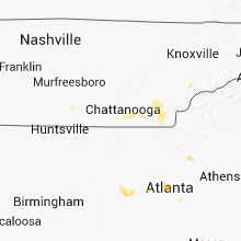
| 1:25 PM EDT | Couple of trees dow in hamilton county TN, 16.7 miles NNE of Chattanooga, TN |
| 2:03 PM EDT | Few trees dow in hamilton county TN, 10.7 miles ENE of Chattanooga, TN |
| 1:40 PM CDT | A tree was blown down. time estimated from rada in franklin county TN, 46.4 miles WNW of Chattanooga, TN |
| 2:42 PM EDT | Quarter sized hail reported near Cleveland, TN, 26.5 miles ENE of Chattanooga, TN |
| 3:12 PM EDT | Several trees down in polk county TN, 44.5 miles E of Chattanooga, TN |
| 3:25 PM EDT | Several trees dow in mcminn county TN, 48.3 miles ENE of Chattanooga, TN |
| 4:20 PM EDT | Dispatch reported several trees dow in monroe county TN, 39.1 miles SW of Knoxville, TN |
| 5:20 PM EDT | Dispatch reported several trees dow in sevier county TN, 22.6 miles SE of Knoxville, TN |
| 6:30 PM EDT | Dispatch reported a few trees dow in sevier county TN, 21.2 miles ESE of Knoxville, TN |
Utah
| Local Time | Report Details |
|---|---|
| 11:45 AM MDT | Wind gust of 63 mph damaged windows on 7 cars at the utah test and training rang in box elder county UT, 56.4 miles WNW of Salt Lake City, UT |
South Carolina
| Local Time | Report Details |
|---|---|
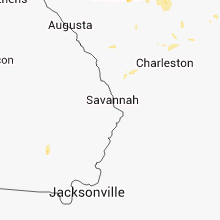
| 1:55 PM EDT | Dot reports a few trees down in the bamberg area over to denmar in bamberg county SC, 55.9 miles ESE of Augusta, GA |
| 2:16 PM EDT | Highway patrol reported power lines down at the intersection of syrup mill road and peach roa in fairfield county SC, 66 miles S of Charlotte, NC |
| 2:40 PM EDT | Sheriff reported trees down on ehrhardt between hwy 301 and ola in bamberg county SC, 52.6 miles ESE of Augusta, GA |
| 2:42 PM EDT | Sheriff reported trees and powerlines down in bamberg with power outages around tow in bamberg county SC, 56 miles ESE of Augusta, GA |
| 2:55 PM EDT | Sc highway patrol reports a tree down at the intersection of us-15 and indian field circl in dorchester county SC, 30.6 miles W of Charleston, SC |
| 3:00 PM EDT | Blythewood fire department reported a tree on a powerline at branham rd and claude bundrick rd. time estimated based on rada in richland county SC, 68.6 miles S of Charlotte, NC |
| 3:02 PM EDT | Powerlines down on table rock roa in greenville county SC, 16 miles N of Greenville, SC |
| 3:23 PM EDT | Tri county electric coop reported trees and power lines down near lone sta in calhoun county SC, 44.3 miles NW of Charleston, SC |
| 3:27 PM EDT | Power lines down on frank clinton rd and asheville hwy. wspa facebook. time estimated with rada in spartanburg county SC, 32.9 miles NE of Greenville, SC |
| 3:27 PM EDT | Tree with power lines down on frank clinton rd and asheville hwy. wspa facebook. time estimated with rada in spartanburg county SC, 32.9 miles NE of Greenville, SC |
| 3:27 PM EDT | Tree in roadway at w georgia rd and garrison rd. schp. time estimated with rada in greenville county SC, 17.7 miles ESE of Greenville, SC |
| 3:30 PM EDT | The colleton county warning point reported trees and powerlines down in the 12000 block of bells crossroad in colleton county SC, 50.8 miles WSW of Charleston, SC |
| 3:36 PM EDT | County warning point reports a large tree down and blocking the road. the tree came down as a result from the outflow boundary in advance of the thunderstorm in dorchester county SC, 19.4 miles SW of Charleston, SC |
| 3:38 PM EDT | Tree down on west gap creek rd near highway 10 in greenville county SC, 22.6 miles ENE of Greenville, SC |
| 3:39 PM EDT | Several trees down near the intersection of hwy 290 and milford church roa in greenville county SC, 18.5 miles NE of Greenville, SC |
| 3:45 PM EDT | Power lines down at jct of anderson rd and white horse rd. time estimated with rada in greenville county SC, 9.1 miles E of Greenville, SC |
| 3:47 PM EDT | Sheriff dispatch reported trees down in the city of camde in kershaw county SC, 67.6 miles S of Charlotte, NC |
| 3:48 PM EDT | Berkeley 911 center reports a tree down on branch road near route 17 in berkeley county SC, 4.2 miles SW of Charleston, SC |
| 4:04 PM EDT | Berkeley 911 center reports a tree down on branch road near route 17 in berkeley county SC, 4.2 miles SW of Charleston, SC |
| 4:08 PM EDT | Sc highway patrol reports a tree down along route 4 in berkeley county SC, 14.2 miles E of Charleston, SC |
| 4:30 PM EDT | Lee county sheriffs office reported multiple powerlines down in bishopville. time estimated based on rada in lee county SC, 71.9 miles N of Charleston, SC |
| 4:32 PM EDT | *** 1 inj *** a person was taken to the hospital after being hit by a falling tree on mechanic street in pendleton. extent of injuries unknown at this tim in anderson county SC, 16.1 miles SW of Greenville, SC |
| 4:50 PM EDT | Schp reported tree in roadway at jalapa rd and cromer r in newberry county SC, 60.6 miles ESE of Greenville, SC |
| 5:06 PM EDT | Schp reported trees in roadway at beaver dam creek rd and bush river rd. time estimate in newberry county SC, 59.9 miles NNE of Augusta, GA |
| 5:36 PM EDT | Sc highway patrol reports a tree down on hendersonville highwa in colleton county SC, 50.1 miles SW of Charleston, SC |
| 5:40 PM EDT | Report of tree down at crossroad of center road and honda wa in florence county SC, 63.2 miles N of Charleston, SC |
| 5:45 PM EDT | The south carolina highway patrol reported a tree down near the intersection of folly creek lane and green pond highwa in colleton county SC, 47.3 miles SW of Charleston, SC |
| 6:02 PM EDT | Schp reported trees in roadway at sc-245 and us-178. time estimated based on rada in lexington county SC, 38 miles NE of Augusta, GA |
| 6:10 PM EDT | Schp reported trees in roadway at lester keisler road and campground road. time estimated based on rada in lexington county SC, 50.4 miles NE of Augusta, GA |
| 6:20 PM EDT | Schp reported trees in roadway at island trail and indian fork road. time estimated based on rada in lexington county SC, 58.8 miles NE of Augusta, GA |
| 6:39 PM EDT | Trees down on i-26 at exit 9 in richland county SC, 62.7 miles NE of Augusta, GA |
North Carolina
| Local Time | Report Details |
|---|---|
| 2:30 PM EDT | Several bradford pear trees split off hwy 158 in the oak valley communit in davie county NC, 57 miles NNE of Charlotte, NC |
| 5:21 PM EDT | Tree down on private property. time based on radar data. report received through social medi in gaston county NC, 18.9 miles W of Charlotte, NC |
| 5:22 PM EDT | Tree on house and power lines down on jackson r in gaston county NC, 20.6 miles W of Charlotte, NC |
| 5:34 PM EDT | Tree down on bensalem church road... time estimated by radar in moore county NC, 64 miles WSW of Raleigh, NC |
| 6:05 PM EDT | Trees snapped in south charlott in mecklenburg county NC, 5 miles S of Charlotte, NC |
| 6:05 PM EDT | Several trees down in 8000 block of newton lane in mecklenburg county NC, 14 miles S of Charlotte, NC |
| 6:34 PM EDT | Public reported 18 or more pear trees and large limbs down in the blakeney area. time based on radar data. report received through social medi in union county NC, 14.2 miles S of Charlotte, NC |
| 6:55 PM EDT | Tree down on st pauls road in hoke county NC, 65 miles SSW of Raleigh, NC |
| 6:55 PM EDT | Tree down on pittman grove church road in hoke county NC, 58.6 miles SSW of Raleigh, NC |
| 6:59 PM EDT | Tree down on red springs road in hoke county NC, 66.2 miles SSW of Raleigh, NC |
| 7:16 PM EDT | Tree down on club pond road in hoke county NC, 61.8 miles SSW of Raleigh, NC |
| 7:30 PM EDT | Report of tree down at intersection of us 71 n and quick road. time estimated by rada in robeson county NC, 67.3 miles SSW of Raleigh, NC |
| 7:30 PM EDT | Report of trees down at intersection of carolina church rd and shaw rd. time estimated by rada in robeson county NC, 65.8 miles SSW of Raleigh, NC |
| 7:35 PM EDT | Report of trees down at intersection of little marsh road and us 301 n. time estimated by rada in robeson county NC, 65.9 miles SSW of Raleigh, NC |
Georgia
| Local Time | Report Details |
|---|---|
| 3:05 PM EDT | Several trees down...fd was dispcthed to remov in rabun county GA, 41.5 miles W of Greenville, SC |
| 5:00 PM EDT | Multiple trees were reported down near highway in lumpkin county GA, 53.1 miles NNE of Atlanta, GA |
| 5:00 PM EDT | Four trees down across northwestern portions of the county including thomas road and price roa in hall county GA, 51.3 miles NNE of Atlanta, GA |
| 5:10 PM EDT | Quarter sized hail reported near Dallas, GA, 26.5 miles WNW of Atlanta, GA |
| 5:20 PM EDT | Several trees were reported down across the county including gillsville road and highway 9 in banks county GA, 58.8 miles NE of Atlanta, GA |
| 5:30 PM EDT | Quarter sized hail reported near Dallas, GA, 26.5 miles WNW of Atlanta, GA, noaa research team relayed a report of quarter sized hail. |
| 6:00 PM EDT | Quarter sized hail reported near Smyrna, GA, 11.4 miles NW of Atlanta, GA |
| 6:00 PM EDT | Quarter sized hail reported near Atlanta, GA, 12.6 miles N of Atlanta, GA |
| 6:18 PM EDT | Haralson county 911 relayed a report of numerous trees down across western haralson count in haralson county GA, 50.9 miles WNW of Atlanta, GA |
| 6:20 PM EDT | Quarter sized hail reported near Atlanta, GA, 12.6 miles N of Atlanta, GA |
| 6:37 PM EDT | Gwinnett police relayed a report of numerous trees down in norcross. more than 6 trees were down for sur in gwinnett county GA, 16.8 miles NE of Atlanta, GA |
| 6:52 PM EDT | 911 call center relayed a report of four trees down in eastern dekalb count in dekalb county GA, 15 miles E of Atlanta, GA |
| 6:52 PM EDT | Dekalb 911 relayed a report of multiple powerlines down in the redan area. time is based on rada in dekalb county GA, 15 miles E of Atlanta, GA |
| 7:07 PM EDT | The media reported a few trees down resulting in power pole damage off lockwood avenu in muscogee county GA, 32.3 miles ESE of Auburn, AL |
| 7:09 PM EDT | Gwinnett police relayed a report of many trees down in the suwanee area. time is based on rada in gwinnett county GA, 27.8 miles NE of Atlanta, GA |
| 7:20 PM EDT | Several trees felled by downburst 5 miles east of nashville. a few of the trees were in berrien county GA, 27.9 miles SW of Douglas, GA |
| 7:25 PM EDT | The media reported three trees down off river road near the muscogee and harris county lin in muscogee county GA, 26.4 miles E of Auburn, AL |
| 8:25 PM EDT | The emergency manager reported at least 30 trees down in the shannon are in floyd county GA, 50.6 miles SSE of Chattanooga, TN |
| 8:45 PM EDT | Bacon county 911 dispatch reports trees and powerlines down along johnsons lake road in the vicnity of rockingham. time of incident based on radar imager in bacon county GA, 26.1 miles E of Douglas, GA |
| 9:00 PM EDT | 6 to 8 trees down...mainly in the eastman are in dodge county GA, 51.6 miles NNW of Douglas, GA |
Florida
| Local Time | Report Details |
|---|---|
| 3:15 PM EDT | A powerline was reported down on county road 315 near florahom in putnam county FL, 44.1 miles SSW of Jacksonville, FL |
| 3:45 PM EDT | Powers lines down in keystone heights in clay county FL, 44.1 miles SSW of Jacksonville, FL |
| 4:15 PM EDT | Power poles snapped in half near the intersection of falkenburg road and highway 60 in brando in hillsborough county FL, 33.9 miles NNE of Bradenton, FL |
| 4:25 PM EDT | Emergency management reported a tree down blocking state route 100 in andalusi in flagler county FL, 58.2 miles S of Jacksonville, FL |
| 4:35 PM EDT | Trees reported down on county road 235 and nickel-size hail. time of report estimated from rada in bradford county FL, 50.5 miles SW of Jacksonville, FL |
| 4:42 PM EDT | Golf Ball sized hail reported near Tampa, FL, 38.2 miles N of Bradenton, FL, the public reported golf ball sized hail on sheldon road. |
| 4:56 PM EDT | Trees down causing road closure on old pasco road in wesley chapel. time is estimated from rada in pasco county FL, 54.6 miles NNE of Bradenton, FL |
| 5:12 PM EDT | Law enforcement relayed a report of trees down on power lines near the intersection of spring lake highway and old spring lake roa in hernando county FL, 56.2 miles W of Orlando, FL |
| 5:45 PM EDT | Baker county 911 dispatch reports a tree downed by strong wind gusts across the intersection of us highway 90 and cow pen road in the vicinity of sanderson. time of inc in baker county FL, 34 miles W of Jacksonville, FL |
| 5:45 PM EDT | Baker county 911 dispatch reports a tree downed by strong wind gusts across turner cemetery road in the vicinity of sanderson. time of incident based on radar imager in baker county FL, 34.9 miles W of Jacksonville, FL |
Alabama
| Local Time | Report Details |
|---|---|
| 3:02 PM CDT | Hand held anemometer measured 65 mph winds on hackberry lan in tuscaloosa county AL, 46.3 miles WSW of Birmingham, AL |
| 3:11 PM CDT | A sign was blown over at a jet-pep gas statio in madison county AL, 70.7 miles ESE of Florence, AL |
| 3:11 PM CDT | A tree was blown dow in madison county AL, 70.8 miles ESE of Florence, AL |
| 3:35 PM CDT | Several trees and power lines blown down in hale county. some of these trees were blocking roadway in hale county AL, 59.4 miles SW of Birmingham, AL |
| 3:57 PM CDT | Storm damage reported in tuscaloosa county AL, 46.3 miles WSW of Birmingham, AL |
| 3:58 PM CDT | A few trees were blown down on hackberry lane and a vehicle was damage in tuscaloosa county AL, 47.2 miles WSW of Birmingham, AL |
| 4:03 PM CDT | A few trees blown down on the east side of tuscaloos in tuscaloosa county AL, 45.7 miles WSW of Birmingham, AL |
| 4:03 PM CDT | Trees blown down and blocking the roadway at highway 69 and tierce roa in tuscaloosa county AL, 43.6 miles WSW of Birmingham, AL |
| 4:08 PM CDT | A small tree was blown down and smashed a fenc in tuscaloosa county AL, 54.1 miles WSW of Birmingham, AL |
| 4:08 PM CDT | *** 1 inj *** a patio cover was blown down and injured the resident. minor damage to the home. winds estimated at 45 mp in elmore county AL, 52.6 miles W of Auburn, AL |
| 4:13 PM CDT | A few trees were blown down in and around cottondal in tuscaloosa county AL, 43.4 miles WSW of Birmingham, AL |
| 4:13 PM CDT | A few trees were blown down in and around wetumpka. winds estimated at 45 mp in elmore county AL, 42.2 miles W of Auburn, AL |
| 4:13 PM CDT | Trees and power lines were blown down in and around wetumpka. winds estimated at 45 mph. a few roads were close in elmore county AL, 42.2 miles W of Auburn, AL |
| 4:17 PM CDT | A few small trees were blown down in northpor in tuscaloosa county AL, 49 miles WSW of Birmingham, AL |
| 4:18 PM CDT | One tree down on a home in millbrook. several reports of winds around 45 mp in elmore county AL, 52.6 miles W of Auburn, AL |
| 4:23 PM CDT | Several trees and power lines blown down in tuscaloosa and in other parts of the count in tuscaloosa county AL, 46.3 miles WSW of Birmingham, AL |
| 4:25 PM CDT | Several trees were blown down on the university of alabama campu in tuscaloosa county AL, 46.3 miles WSW of Birmingham, AL |
| 4:34 PM CDT | Several trees and power lines were blown down in and around clanto in chilton county AL, 48 miles SSE of Birmingham, AL |
| 4:35 PM CDT | A few trees were blown down near the tuscaloosa and fayette county line on highway 17 in tuscaloosa county AL, 56.7 miles W of Birmingham, AL |
| 5:09 PM CDT | One tree blown down in eclecti in elmore county AL, 32.1 miles W of Auburn, AL |
| 5:10 PM CDT | Trees and power lines down on independence driv in shelby county AL, 18.6 miles S of Birmingham, AL |
| 5:11 PM CDT | A tree was blown down in the friendship communit in elmore county AL, 24.3 miles W of Auburn, AL |
| 5:12 PM CDT | A tree was blown down on highway 1 in shelby county AL, 16 miles S of Birmingham, AL |
| 5:22 PM CDT | Trees and power lines blown down near the dollar general in columbian in shelby county AL, 26.5 miles SSE of Birmingham, AL |
| 5:25 PM CDT | A large tree was blown down on highway 32 and was blocking the roadwa in shelby county AL, 16.4 miles SE of Birmingham, AL |
| 5:25 PM CDT | A large tree was blown down on highway 55 and was blocking the roadwa in shelby county AL, 19.6 miles SE of Birmingham, AL |
| 5:39 PM CDT | Power lines down in vehicle in shelby county AL, 25.3 miles ESE of Birmingham, AL |
| 5:39 PM CDT | Power lines down on vehicle in shelby county AL, 25.3 miles ESE of Birmingham, AL |
| 5:40 PM CDT | Large 36 inch diameter oak tree snapped at the base in wilsonville at the intersection of hebb road and county road 6 in shelby county AL, 27.7 miles SE of Birmingham, AL |
| 5:55 PM CDT | A tree was blown down on renfroe road and plant roa in talladega county AL, 41.6 miles E of Birmingham, AL |
| 5:55 PM CDT | A few trees were blown down in several locations across lee count in lee county AL, 4.3 miles N of Auburn, AL |
| 6:00 PM CDT | A few trees blown down near cook spring in talladega county AL, 37.1 miles E of Birmingham, AL |
| 6:02 PM CDT | A tree was blown down on fish hatchery roa in calhoun county AL, 46.1 miles E of Birmingham, AL |
| 6:05 PM CDT | One tree blown down in sycamor in talladega county AL, 40 miles ESE of Birmingham, AL |
| 6:16 PM CDT | A tree was blown down and blocking a road in woodhaven just east of highway 7 in blount county AL, 29.6 miles NNE of Birmingham, AL |
| 6:19 PM CDT | A tree was blown down on interstate 20 near exit 162. one lane was blocke in talladega county AL, 39.1 miles E of Birmingham, AL |
| 6:19 PM CDT | A tree was blown down and blocking mountain view roa in st. clair county AL, 25.4 miles NE of Birmingham, AL |
Montana
| Local Time | Report Details |
|---|---|
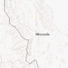
| 3:45 PM MDT | 64 mph wind gust reported from a thunderstorm near big hole pas in beaverhead county MT, 30.3 miles ENE of Salmon, ID |
| 6:55 PM MDT | 59 mph thunderstorm wind gust reported at bozeman pas in gallatin county MT, 10.3 miles E of Bozeman, MT |
| 7:22 PM MDT | Storm damage reported in park county MT, 22.9 miles E of Bozeman, MT |
| 9:09 PM MDT | Storm damage reported in stillwater county MT, 30.9 miles WSW of Billings, MT |
Wyoming
| Local Time | Report Details |
|---|---|
| 3:50 PM MDT | No damage reported in hot springs county WY, 44.5 miles N of Riverton, WY |
| 5:16 PM MDT | Storm damage reported in big horn county WY, 89.7 miles SSE of Billings, MT |
Connect with Interactive Hail Maps