

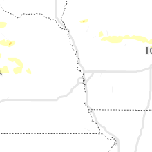
Hail Map for Sunday, July 10, 2022

Number of Impacted Households on 7/10/2022
0
Impacted by 1" or Larger Hail
0
Impacted by 1.75" or Larger Hail
0
Impacted by 2.5" or Larger Hail
Square Miles of Populated Area Impacted on 7/10/2022
0
Impacted by 1" or Larger Hail
0
Impacted by 1.75" or Larger Hail
0
Impacted by 2.5" or Larger Hail


Cities Most Affected by Hail Storms of 7/10/2022
| Hail Size | Demographics of Zip Codes Affected | ||||||
|---|---|---|---|---|---|---|---|
| City | Count | Average | Largest | Pop Density | House Value | Income | Age |
| Padroni, CO | 1 | 1.75 | 1.75 | 0 | $63k | $37.7k | 47.6 |
| Champion, NE | 1 | 1.75 | 1.75 | 2 | $35k | $30.3k | 45.6 |
Hail and Wind Damage Spotted on 7/10/2022
Filter by Report Type:Hail ReportsWind Reports
States Impacted
North Dakota, Minnesota, Iowa, Texas, Florida, Colorado, Wyoming, Nebraska, Montana, South DakotaNorth Dakota
| Local Time | Report Details |
|---|---|
| 7:35 AM CDT | Rwis report of 68mph wind gus in grand forks county ND, 69.6 miles E of Devils Lake, ND |
| 7:37 AM CDT | Ndawn station measured 59mph wind gust at 10 meter in grand forks county ND, 72.5 miles E of Devils Lake, ND |
| 7:53 AM CDT | 58mph wind gust reported at the gfk airpor in grand forks county ND, 75 miles NNW of Fargo, ND |
| 8:05 AM CDT | Tree branches down... relayed via facebook. time estimated from rada in traill county ND, 57 miles NNW of Fargo, ND |
| 8:11 AM CDT | Ndawn wind gust of 60mph at 10 meter in cass county ND, 12.7 miles WNW of Fargo, ND |
| 1:00 PM CDT | Quarter sized hail reported near Enderlin, ND, 42.7 miles WSW of Fargo, ND, pea to quarter size hail. time estimated. |
| 1:14 PM CDT | Quarter sized hail reported near Enderlin, ND, 43.7 miles WSW of Fargo, ND |
| 1:15 PM CDT | Quarter sized hail reported near Enderlin, ND, 42.7 miles WSW of Fargo, ND, corrects previous hail report from enderlin. pea to quarter size hail. time estimated. |
| 1:28 PM CDT | Quarter sized hail reported near Sheldon, ND, 38.6 miles WSW of Fargo, ND, relayed via media partner. |
| 2:21 PM CDT | Half Dollar sized hail reported near Wahpeton, ND, 36.4 miles S of Fargo, ND |
Minnesota
| Local Time | Report Details |
|---|---|
| 8:06 AM CDT | Wind gust via personal weather statio in marshall county MN, 64.7 miles WSW of Roseau, MN |
| 8:19 AM CDT | Tree branches down and fence posts blown dow in marshall county MN, 59.5 miles SW of Roseau, MN |
| 8:26 AM CDT | Reported via a personal weather statio in marshall county MN, 51 miles WSW of Roseau, MN |
| 8:33 AM CDT | Tree on house and car in newfolden. time estimate in marshall county MN, 42.2 miles SW of Roseau, MN |
| 9:10 AM CDT | Corrects previous tstm wnd gst report from waukon. ndawn report of 59mph wind gus in norman county MN, 45.9 miles NE of Fargo, ND |
| 10:40 AM CDT | Cass county dispatch reported a power line down near hackensack. time estimated by rada in cass county MN, 41 miles SSE of Bemidji, MN |
| 11:10 AM CDT | Cass county dispatch reported a large tree down across a road south of remer. time estimated by rada in cass county MN, 57.6 miles SE of Bemidji, MN |
| 12:45 PM CDT | Half Dollar sized hail reported near Detroit Lakes, MN, 48 miles E of Fargo, ND, size estimated by picture shared on social media. |
| 1:00 PM CDT | Quarter sized hail reported near Detroit Lakes, MN, 48.5 miles E of Fargo, ND |
| 1:18 PM CDT | Ping Pong Ball sized hail reported near Lake Park, MN, 34.1 miles ESE of Fargo, ND, corrects previous hail report from 3 nnw cormorant. relayed via broadcast media partner. time estimated via radar. |
| 1:23 PM CDT | Ping Pong Ball sized hail reported near Menahga, MN, 51.7 miles SSW of Bemidji, MN, estimated size from picture shared on social media. |
| 1:29 PM CDT | Ping Pong Ball sized hail reported near Lake Park, MN, 34.1 miles ESE of Fargo, ND, relayed via broadcast media partner. |
| 1:33 PM CDT | Ping Pong Ball sized hail reported near Osage, MN, 42 miles SSW of Bemidji, MN, relayed via broadcast media partner. |
| 1:33 PM CDT | Ping Pong Ball sized hail reported near Osage, MN, 46.9 miles SSW of Bemidji, MN, relayed via broadcast media partner. |
| 1:40 PM CDT | Half Dollar sized hail reported near Frazee, MN, 52.3 miles E of Fargo, ND, relayed via broadcast media partner. time estimated via radar. |
| 1:45 PM CDT | Quarter sized hail reported near Menahga, MN, 45.2 miles S of Bemidji, MN, pea to quarter size hail. |
| 4:35 PM CDT | Photos sent in via social media of a cluster of trees that snapped near the trunk as well as a spruce tree that was uprooted. time is approximated from rada in pine county MN, 56.7 miles SW of Duluth, MN |
| 4:36 PM CDT | Two large spruce trees were downed with at least one uprooted. report and photo relayed via social media. time estimated by rada in pine county MN, 54.4 miles SW of Duluth, MN |
| 4:39 PM CDT | A portion of interstate 35 southbound lane was blocked by a large fallen tree. time estimated by rada in pine county MN, 53.3 miles SW of Duluth, MN |
| 5:00 PM CDT | Report of tree down over a portion of highway 48 east of cloverdale. time estimated by rada in pine county MN, 61.4 miles SSW of Duluth, MN |
Iowa
| Local Time | Report Details |
|---|---|
| 11:06 AM CDT | Quarter sized hail reported near Riceville, IA, 36 miles ENE of Mason City, IA |
| 3:15 AM CDT | Public reported via social media a downed 12 inch diameter tree branch that fell through a windo in monona county IA, 51 miles N of Omaha, NE |
| 3:37 AM CDT | Storm damage reported in crawford county IA, 46.3 miles SSW of Storm Lake, IA |
| 3:40 AM CDT | Lots of reports of trees down on local scanner in denison. time estimate in crawford county IA, 44 miles S of Storm Lake, IA |
| 3:59 AM CDT | Personal weather station kiacarro2 in carroll county IA, 41.7 miles SSE of Storm Lake, IA |
| 4:05 AM CDT | Storm damage reported in carroll county IA, 46.3 miles SSE of Storm Lake, IA |
| 4:18 AM CDT | Personal weather station kiajeffe in greene county IA, 54.3 miles NW of Des Moines, IA |
| 4:24 AM CDT | Personal weather station kiajeffe in greene county IA, 47.3 miles NW of Des Moines, IA |
| 4:34 AM CDT | Tree limbs down in jefferson along with power ou in greene county IA, 48.6 miles NW of Des Moines, IA |
| 4:46 AM CDT | Mesonet station fw3793 jefferso in greene county IA, 49 miles NW of Des Moines, IA |
| 4:47 AM CDT | Storm damage reported in boone county IA, 34 miles NNW of Des Moines, IA |
| 4:49 AM CDT | Personal weather station kiabouto in boone county IA, 28.9 miles NW of Des Moines, IA |
| 5:03 AM CDT | 18 inch diameter tree snapped in half. image posted on social media. time estimated from rada in story county IA, 42.6 miles NNE of Des Moines, IA |
| 5:05 AM CDT | Corrects previous tstm wnd gst report from 2 s ame in story county IA, 27.6 miles N of Des Moines, IA |
| 5:08 AM CDT | Large tree limbs down in west ame in story county IA, 29.9 miles N of Des Moines, IA |
| 6:28 AM CDT | Quarter sized hail reported near Riverside, IA, 34.6 miles S of Cedar Rapids, IA, reported dime to quarter sized hail via ham radio. |
| 6:28 AM CDT | 2 inch branches dow in washington county IA, 34.6 miles S of Cedar Rapids, IA |
Texas
| Local Time | Report Details |
|---|---|
| 3:56 PM CDT | Measured by san marcos regional airport awo in caldwell county TX, 49.9 miles NE of San Antonio, TX |
| 4:17 PM CDT | Several large tree limbs snapped in mission hills ranch subdivision. microburst evident on radar at the tim in comal county TX, 27.7 miles NE of San Antonio, TX |
| 4:55 PM CDT | Measured by kerrville awo in kerr county TX, 51.5 miles NW of San Antonio, TX |
| 5:32 PM CDT | 8 rvs were pushed over at a dealership and repair sho in travis county TX, 66.6 miles NE of San Antonio, TX |
| 6:08 PM CDT | Trees and fences downed just inside bastrop county on fm 672 near the caldwell county line and st. johns colon in bastrop county TX, 69 miles NE of San Antonio, TX |
Florida
| Local Time | Report Details |
|---|---|
| 5:00 PM EDT | Ussf wind tower 19 measured a peak wind gust of 51kts/59mph from the southwes in brevard county FL, 43.4 miles ENE of Orlando, FL |
Colorado
| Local Time | Report Details |
|---|---|
| 4:42 PM MDT | Golf Ball sized hail reported near Padroni, CO, 55.9 miles NNW of Yuma, CO, delayed report. up to golf ball sized hail fell just northeast of the north sterling reservoir. most hail was quarter size or smaller. time estimated by radar. |
| 6:05 PM MDT | Asos station kcos colorado springs airpor in el paso county CO, 38.5 miles N of Pueblo, CO |
Wyoming
| Local Time | Report Details |
|---|---|
| 6:44 PM MDT | Storm damage reported in sheridan county WY, 79.8 miles SE of Billings, MT |
| 8:45 PM MDT | Storm damage reported in crook county WY, 62.7 miles NE of Gillette, WY |
Nebraska
| Local Time | Report Details |
|---|---|
| 6:49 PM MDT | Golf Ball sized hail reported near Champion, NE, 52.3 miles ENE of Yuma, CO, relayed report from co-op observer of golf ball size hail. |
| 6:49 PM MDT | Quarter sized hail reported near Champion, NE, 56.8 miles ENE of Yuma, CO |
| 6:50 PM MDT | Quarter sized hail reported near Imperial, NE, 58.8 miles ENE of Yuma, CO, estimated time from radar. |
| 6:50 PM MDT | Estimated time based on radar. 60 mph winds shredded leaves and blew walnuts off tree in chase county NE, 58.8 miles ENE of Yuma, CO |
| 6:54 PM MDT | Half Dollar sized hail reported near Imperial, NE, 58.8 miles ENE of Yuma, CO |
| 7:05 PM MDT | Estimated time based on rada in chase county NE, 56.5 miles ENE of Yuma, CO |
| 10:37 PM MDT | Damage in town to shingles... trees and power lines from southerly thunderstorm outflow wind in perkins county NE, 54.5 miles WSW of North Platte, NE |
| 10:45 PM MDT | Damage in town to shingles... trees and power lines from thunderstorm outflow wind in perkins county NE, 54.5 miles WSW of North Platte, NE |
| 11:59 PM CDT | Storm damage reported in valley county NE, 57.5 miles NNW of Grand Island, NE |
| 12:50 AM CDT | Storm damage reported in boone county NE, 57.6 miles NNE of Grand Island, NE |
| 1:29 AM CDT | Storm damage reported in platte county NE, 70.9 miles NE of Grand Island, NE |
| 1:30 AM CDT | Storm damage reported in platte county NE, 74.4 miles NE of Grand Island, NE |
| 1:04 AM MDT | Imperial airport in chase county NE, 62.6 miles SW of North Platte, NE |
| 2:15 AM CDT | Storm damage reported in cuming county NE, 56.5 miles NW of Omaha, NE |
| 2:33 AM CDT | Storm damage reported in burt county NE, 37.3 miles NNW of Omaha, NE |
| 2:41 AM CDT | Updates previous tstm wnd gst report from 2 ese tekama in burt county NE, 37.3 miles NNW of Omaha, NE |
| 2:45 AM CDT | Updates previous tstm wnd gst report from 2 ese tekama in burt county NE, 37.3 miles NNW of Omaha, NE |
| 4:32 AM CDT | Heat burst from decaying thunderstorms produced this severe wind gus in york county NE, 45.4 miles E of Grand Island, NE |
Montana
| Local Time | Report Details |
|---|---|
| 8:30 PM MDT | Quarter sized hail reported near Alzada, MT, 62.5 miles NNE of Gillette, WY, heavy rain and gusty winds. |
| 8:46 PM MDT | Storm damage reported in carter county MT, 74.2 miles NE of Gillette, WY |
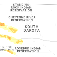
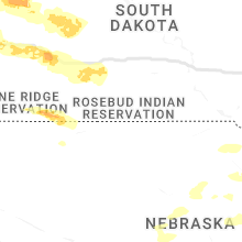
South Dakota
| Local Time | Report Details |
|---|---|
| 9:25 PM MDT | Storm damage reported in butte county SD, 61.7 miles NNW of Rapid City, SD |
| 9:40 PM MDT | Quarter sized hail reported near Spearfish, SD, 49.5 miles NW of Rapid City, SD |
| 9:51 PM MDT | Storm damage reported in lawrence county SD, 38.9 miles WNW of Rapid City, SD |
| 10:15 PM MDT | Storm damage reported in meade county SD, 41.6 miles NE of Rapid City, SD |
| 10:20 PM MDT | Storm damage reported in meade county SD, 13.8 miles NW of Rapid City, SD |
| 10:20 PM MDT | Storm damage reported in meade county SD, 41.6 miles NE of Rapid City, SD |
| 10:20 PM MDT | Ping Pong Ball sized hail reported near Piedmont, SD, 13.8 miles NW of Rapid City, SD |
| 10:24 PM MDT | Ping Pong Ball sized hail reported near Piedmont, SD, 10.2 miles NW of Rapid City, SD |
| 10:32 PM MDT | Storm damage reported in meade county SD, 8.5 miles NE of Rapid City, SD |
| 10:35 PM MDT | Storm damage reported in pennington county SD, 7.5 miles ENE of Rapid City, SD |
| 10:36 PM MDT | Storm damage reported in pennington county SD, 1.3 miles SE of Rapid City, SD |
| 10:36 PM MDT | Storm damage reported in meade county SD, 8.5 miles NE of Rapid City, SD |
| 10:39 PM MDT | Storm damage reported in meade county SD, 11 miles N of Rapid City, SD |
| 10:39 PM MDT | Storm damage reported in meade county SD, 8.5 miles NE of Rapid City, SD |
| 10:40 PM MDT | Storm damage reported in pennington county SD, 9.3 miles ESE of Rapid City, SD |
| 10:40 PM MDT | Storm damage reported in pennington county SD, 7.5 miles ENE of Rapid City, SD |
| 10:44 PM MDT | Quarter sized hail reported near Rapid City, SD, 5.1 miles E of Rapid City, SD |
| 10:45 PM MDT | Storm damage reported in pennington county SD, 9.3 miles ESE of Rapid City, SD |
| 10:47 PM MDT | Storm damage reported in pennington county SD, 15.2 miles E of Rapid City, SD |
| 10:52 PM MDT | Storm damage reported in pennington county SD, 15.2 miles E of Rapid City, SD |
| 10:57 PM MDT | Storm damage reported in pennington county SD, 9.3 miles ESE of Rapid City, SD |
| 11:17 PM MDT | Storm damage reported in custer county SD, 29.1 miles SSE of Rapid City, SD |
| 11:20 PM MDT | Storm damage reported in pennington county SD, 37.1 miles ESE of Rapid City, SD |
| 11:30 PM MDT | Storm damage reported in pennington county SD, 37.1 miles ESE of Rapid City, SD |
| 11:34 PM MDT | Storm damage reported in haakon county SD, 53.4 miles W of Pierre, SD |
| 11:47 PM MDT | Storm damage reported in haakon county SD, 53.4 miles W of Pierre, SD |
| 12:11 AM MDT | Storm damage reported in haakon county SD, 44 miles WSW of Pierre, SD |
| 12:18 AM MDT | Storm damage reported in jackson county SD, 69.1 miles NW of Valentine, NE |
| 1:26 AM CDT | Asos station kpir pierre muni a in hughes county SD, 3.6 miles ENE of Pierre, SD |
Connect with Interactive Hail Maps