

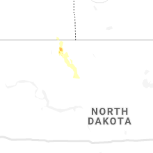
Hail Map for Thursday, July 15, 2021

Number of Impacted Households on 7/15/2021
0
Impacted by 1" or Larger Hail
0
Impacted by 1.75" or Larger Hail
0
Impacted by 2.5" or Larger Hail
Square Miles of Populated Area Impacted on 7/15/2021
0
Impacted by 1" or Larger Hail
0
Impacted by 1.75" or Larger Hail
0
Impacted by 2.5" or Larger Hail


Cities Most Affected by Hail Storms of 7/15/2021
| Hail Size | Demographics of Zip Codes Affected | ||||||
|---|---|---|---|---|---|---|---|
| City | Count | Average | Largest | Pop Density | House Value | Income | Age |
| Karval, CO | 1 | 2.00 | 2.00 | 0 | $40k | $29.5k | 46.4 |
| Maxwell, NM | 1 | 1.75 | 1.75 | 1 | $63k | $27.9k | 43.4 |
| Gibson City, IL | 1 | 1.75 | 1.75 | 42 | $75k | $35.2k | 42.7 |
Hail and Wind Damage Spotted on 7/15/2021
Filter by Report Type:Hail ReportsWind Reports
States Impacted
Indiana, Illinois, Nevada, Arizona, Colorado, Georgia, Utah, Ohio, Wyoming, New Mexico, Virginia, Texas, Pennsylvania, Oklahoma, Idaho, New York, MontanaIndiana
| Local Time | Report Details |
|---|---|
| 3:56 PM EDT | Awos station kgus grissom afb per in miami county IN, 59.6 miles N of Indianapolis, IN |
| 4:00 PM EDT | Several tree branches broke in miami county IN, 59 miles N of Indianapolis, IN |
| 4:20 PM EDT | Tv media received a photograph from a viewer of metal roofing removed from a small barn. the viewer also reported small limbs down. time very roughly estimated from rad in carroll county IN, 55.7 miles NNW of Indianapolis, IN |
| 5:55 PM EDT | Tree blew down by thunderstorm winds. time estimated from rada in hendricks county IN, 13.4 miles WSW of Indianapolis, IN |
| 5:55 PM EDT | Tree or trees down and a trampoline badly damaged as it was blown into the street. time approximated from rada in hendricks county IN, 12.9 miles W of Indianapolis, IN |
Illinois
| Local Time | Report Details |
|---|---|
| 4:22 PM CDT | Quarter sized hail reported near Mount Pulaski, IL, 49.8 miles SSE of Peoria, IL, dime to quarter size hail. |
| 5:22 PM CDT | Golf Ball sized hail reported near Gibson City, IL, 64.9 miles N of Mattoon, IL, photo of golf ball size hail shared on social media. time estimated. |
Nevada
| Local Time | Report Details |
|---|---|
| 2:27 PM PDT | Pancake raws elevation 516 in nye county NV, 95.7 miles SW of Ely, NV |
| 3:27 PM PDT | Corrects previous tstm wnd gst report from 38 wsw blue eagle ranch. pancake raws (pann2) elevation 516 in nye county NV, 95.7 miles SW of Ely, NV |
Arizona
| Local Time | Report Details |
|---|---|
| 2:55 PM MST | 20 trees down in multiple locations along n. sunrise blvd. between remington dr. and mountain view blvd. radar estimated winds between 40-50 mph around this time. consi in maricopa county AZ, 23.7 miles NW of Phoenix, AZ |
| 2:55 PM MST | 15 trees down along n. reems rd. near mountain view blvd. radar estimated winds between 40-50 mph during this tim in maricopa county AZ, 22.4 miles NW of Phoenix, AZ |
| 3:07 PM MST | Asos station ksad safford regional airpor in graham county AZ, 79 miles W of Silver City, NM |
| 4:07 PM MST | Ksad measured wind gust to 62 mp in graham county AZ, 79.6 miles W of Silver City, NM |
| 5:08 PM MST | Video on social media showed tree blocking power rd. near intersection of power rd. and mckellips rd. radar estimated winds of 55-60 mph during this tim in maricopa county AZ, 22.9 miles E of Phoenix, AZ |
| 5:10 PM MST | Mesonet station srp10 6.5 n east mesa (srp in maricopa county AZ, 22.7 miles E of Phoenix, AZ |
| 5:10 PM MST | Two 50 foot trees were uprooted and each one fell on two separate homes at apache wells golf course. one of the trees reportedly fell from storms on july 10th. no injur in maricopa county AZ, 21.2 miles E of Phoenix, AZ |
| 5:12 PM MST | Awos station kffz mesa falcon fl in maricopa county AZ, 20.6 miles E of Phoenix, AZ |
Colorado
| Local Time | Report Details |
|---|---|
| 4:00 PM MDT | Hen Egg sized hail reported near Karval, CO, 64.2 miles ENE of Pueblo, CO, spotter report of a few hen egg sized hailstones. time estimated by radar. |
| 4:00 PM MDT | A few branches down. spotter estimated gusts up to 60mph. time estimated by rada in lincoln county CO, 64.2 miles ENE of Pueblo, CO |
Georgia
| Local Time | Report Details |
|---|---|
| 6:10 PM EDT | Reports of trees and power lines dow in seminole county GA, 55.7 miles NW of Tallahassee, FL |
Utah
| Local Time | Report Details |
|---|---|
| 4:15 PM MDT | Salt flats dugway mesonet sit in tooele county UT, 76.8 miles WSW of Salt Lake City, UT |
| 5:00 PM MDT | I-80 at mile post in tooele county UT, 92.4 miles E of Elko, NV |
| 5:00 PM MDT | Wendover point of entry in tooele county UT, 93.4 miles E of Elko, NV |
| 5:20 PM MDT | Arnosa mesonet site in tooele county UT, 88.8 miles W of Salt Lake City, UT |
| 5:30 PM MDT | Romeo and centerline mesonet sit in tooele county UT, 79.1 miles WSW of Salt Lake City, UT |
| 5:40 PM MDT | Upper cedar mountain sit in tooele county UT, 64.4 miles WSW of Salt Lake City, UT |
Ohio
| Local Time | Report Details |
|---|---|
| 6:16 PM EDT | Trees dow in fayette county OH, 40.1 miles SSW of Columbus, OH |
| 6:16 PM EDT | Trees dow in fayette county OH, 37.5 miles SSW of Columbus, OH |
| 7:07 PM EDT | Several large limbs dow in geauga county OH, 35 miles ENE of Cleveland, OH |
| 7:22 PM EDT | Tree dow in ashtabula county OH, 38.7 miles E of Cleveland, OH |
| 7:25 PM EDT | Tree dow in ashtabula county OH, 54.4 miles ENE of Cleveland, OH |
| 7:36 PM EDT | Tree and wires dow in ashtabula county OH, 41.6 miles E of Cleveland, OH |
| 7:44 PM EDT | Multiple trees and wires down in the are in ashtabula county OH, 42.6 miles E of Cleveland, OH |
Wyoming
| Local Time | Report Details |
|---|---|
| 4:24 PM MDT | Quarter sized hail reported near Cheyenne, WY, 46.5 miles E of Laramie, WY, nickels to quarters reported. |
| 4:27 PM MDT | Quarter sized hail reported near Cheyenne, WY, 46.5 miles E of Laramie, WY |
| 4:30 PM MDT | Quarter sized hail reported near Cheyenne, WY, 46.6 miles E of Laramie, WY |
New Mexico
| Local Time | Report Details |
|---|---|
| 4:25 PM MDT | Mesonet station nm004 lordsburg playa i10 mp12 (nmdot). corrects previous lsr for event typ in hidalgo county NM, 48 miles SW of Silver City, NM |
| 4:35 PM MDT | Mesonet station nm003 lordsburg playa i10 mp11 (nmdot). corrects previous lsr for event typ in hidalgo county NM, 48.9 miles SW of Silver City, NM |
| 6:06 PM MDT | Golf Ball sized hail reported near Maxwell, NM, 49.5 miles ENE of Taos, NM |
Virginia
| Local Time | Report Details |
|---|---|
| 6:34 PM EDT | Tree down in brightwoo in madison county VA, 69.7 miles NNW of Richmond, VA |
| 6:36 PM EDT | Tree down in radian in madison county VA, 63.2 miles NNW of Richmond, VA |
Texas
| Local Time | Report Details |
|---|---|
| 6:04 PM CDT | West texas mesonet in briscoe county TX, 55.9 miles W of Childress, TX |
| 7:09 PM CDT | West texas mesonet in briscoe county TX, 48.5 miles W of Childress, TX |
| 8:10 PM CDT | Storm damage reported in lubbock county TX, 16.3 miles SW of Lubbock, TX |
Pennsylvania
| Local Time | Report Details |
|---|---|
| 7:41 PM EDT | Tree and power pole down at s. beaver center rd. and sr-19 in crawford county PA, 65.6 miles ENE of Cleveland, OH |
| 7:52 PM EDT | Tree dow in crawford county PA, 70.6 miles ENE of Cleveland, OH |
| 8:22 PM EDT | Tree dow in erie county PA, 89.6 miles SW of Buffalo, NY |
| 8:22 PM EDT | Tree down on roa in crawford county PA, 73.4 miles E of Cleveland, OH |
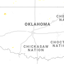
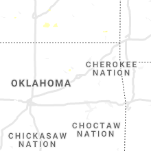
Oklahoma
| Local Time | Report Details |
|---|---|
| 7:07 PM CDT | Quarter sized hail reported near Fort Supply, OK, 13.4 miles NW of Woodward, OK, nwschat report. |
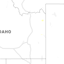
Idaho
| Local Time | Report Details |
|---|---|
| 6:25 PM MDT | Dubois arl sit in clark county ID, 52.2 miles N of Idaho Falls, ID |
| 6:30 PM MDT | China point itd sit in clark county ID, 58.3 miles N of Idaho Falls, ID |
New York
| Local Time | Report Details |
|---|---|
| 8:40 PM EDT | Tree down on lakeside drive blocking roadwa in chautauqua county NY, 55.9 miles SSW of Buffalo, NY |
Montana
| Local Time | Report Details |
|---|---|
| 9:18 PM MDT | Storm damage reported in park county MT, 28.3 miles E of Bozeman, MT |
Connect with Interactive Hail Maps