

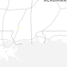
Hail Map for Friday, July 15, 2022

Number of Impacted Households on 7/15/2022
0
Impacted by 1" or Larger Hail
0
Impacted by 1.75" or Larger Hail
0
Impacted by 2.5" or Larger Hail
Square Miles of Populated Area Impacted on 7/15/2022
0
Impacted by 1" or Larger Hail
0
Impacted by 1.75" or Larger Hail
0
Impacted by 2.5" or Larger Hail


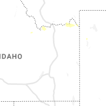


Cities Most Affected by Hail Storms of 7/15/2022
| Hail Size | Demographics of Zip Codes Affected | ||||||
|---|---|---|---|---|---|---|---|
| City | Count | Average | Largest | Pop Density | House Value | Income | Age |
| Laurel, MT | 1 | 1.75 | 1.75 | 60 | $94k | $38.7k | 39.5 |
Hail and Wind Damage Spotted on 7/15/2022
Filter by Report Type:Hail ReportsWind Reports
States Impacted
Minnesota, Washington, Virginia, Montana, Wyoming, Florida, Nevada, Colorado, South Dakota, Mississippi, IllinoisMinnesota
| Local Time | Report Details |
|---|---|
| 7:00 AM CDT | One tree down on power lines. time estimate in winona county MN, 28.9 miles NW of La Crosse, WI |
Washington
| Local Time | Report Details |
|---|---|
| 7:55 AM PDT | Quarter sized hail reported near Colfax, WA, 51 miles S of Spokane, WA |
Virginia
| Local Time | Report Details |
|---|---|
| 1:30 PM EDT | Tree downed onto a power line at oakley l in gloucester county VA, 56.3 miles E of Richmond, VA |
| 2:40 PM EDT | Tree downed onto a powerline off of va-19 in gloucester county VA, 56.4 miles NNW of Virginia Beach, VA |
Montana
| Local Time | Report Details |
|---|---|
| 12:29 PM MDT | Via ambient weathe in cascade county MT, 13.7 miles SW of Great Falls, MT |
| 1:02 PM MDT | Storm damage reported in wheatland county MT, 66.1 miles NE of Bozeman, MT |
| 1:06 PM MDT | Storm damage reported in wheatland county MT, 66.1 miles NE of Bozeman, MT |
| 3:15 PM MDT | Storm damage reported in yellowstone county MT, 11.7 miles WNW of Billings, MT |
| 3:19 PM MDT | Quarter sized hail reported near Nye, MT, 62.3 miles ESE of Bozeman, MT |
| 3:20 PM MDT | Ping Pong Ball sized hail reported near Laurel, MT, 13.3 miles WSW of Billings, MT |
| 3:20 PM MDT | Golf Ball sized hail reported near Laurel, MT, 15 miles WSW of Billings, MT, mostly ping pong size a couple golf ball size though. |
| 3:23 PM MDT | Storm damage reported in yellowstone county MT, 3.9 miles N of Billings, MT |
| 3:25 PM MDT | Storm damage reported in yellowstone county MT, 2.8 miles NW of Billings, MT |
| 3:40 PM MDT | Tree fell over (trunk 1.5 ft in diameter) in yellowstone county MT, 1 miles SSE of Billings, MT |
| 4:05 PM MDT | Measured with handheld anemomete in big horn county MT, 43.3 miles E of Billings, MT |
| 4:30 PM MDT | Storm damage reported in big horn county MT, 44.1 miles E of Billings, MT |
| 4:30 PM MDT | Storm damage reported in rosebud county MT, 30.4 miles WNW of Miles City, MT |
| 4:30 PM MDT | Gusts up to 64 mph produced visibility under a quarter mile in blowing dust. major accident i-90 resulting in at least 5 fatalitie in big horn county MT, 40.5 miles E of Billings, MT |
| 4:50 PM MDT | Mobile home lost roo in big horn county MT, 49.2 miles E of Billings, MT |
| 4:55 PM MDT | Visibility under a quarter mile in blowing dust in big horn county MT, 41 miles E of Billings, MT |
| 4:57 PM MDT | Storm damage reported in rosebud county MT, 74.9 miles W of Miles City, MT |
| 5:04 PM MDT | Storm damage reported in rosebud county MT, 74.9 miles W of Miles City, MT |
| 5:19 PM MDT | Storm damage reported in rosebud county MT, 74.9 miles W of Miles City, MT |
| 5:29 PM MDT | Storm damage reported in carbon county MT, 49.2 miles SSE of Billings, MT |
| 5:46 PM MDT | Mesonet station mtmqm monida pass (mt dot in beaverhead county MT, 74.9 miles N of Idaho Falls, ID |
| 6:39 PM MDT | Storm damage reported in rosebud county MT, 35.4 miles NW of Miles City, MT |
| 6:59 PM MDT | Storm damage reported in rosebud county MT, 41.4 miles W of Miles City, MT |
| 9:03 PM MDT | Quarter sized hail reported near Fallon, MT, 60.4 miles ENE of Miles City, MT, trained spotter reported hail stones up to the size of quarters. |
Wyoming
| Local Time | Report Details |
|---|---|
| 4:15 PM MDT | Awos station ku68 cowley airpor in big horn county WY, 59.7 miles S of Billings, MT |
| 5:49 PM MDT | Willow creek raws - tt63 in big horn county WY, 68.3 miles SSE of Billings, MT |
| 6:01 PM MDT | Storm damage reported in sheridan county WY, 79.5 miles WNW of Gillette, WY |
| 6:16 PM MDT | Storm damage reported in sheridan county WY, 71.1 miles WNW of Gillette, WY |
| 6:17 PM MDT | Asos station kgey greybull airpor in big horn county WY, 89.7 miles SSE of Billings, MT |
| 6:30 PM MDT | Storm damage reported in sheridan county WY, 91.9 miles WNW of Gillette, WY |
| 6:53 PM MDT | Asos station kbyg buffalo airpor in johnson county WY, 60.5 miles W of Gillette, WY |
Florida
| Local Time | Report Details |
|---|---|
| 7:20 PM EDT | Marion county emergency management reports multiple downed powerlines in the vicinity of state road 200 to the south of the ocala international airport. time of damage in marion county FL, 65.7 miles NW of Orlando, FL |
Nevada
| Local Time | Report Details |
|---|---|
| 4:30 PM PDT | Mesonet station schnv 12.1 se ely (nv dot) station elevation: 6687 f in white pine county NV, 12.5 miles SE of Ely, NV |
| 5:50 PM PDT | Salt desert shrub (dnep8)... elevation 5185 fee in white pine county NV, 47.1 miles ESE of Ely, NV |
Colorado
| Local Time | Report Details |
|---|---|
| 6:22 PM MDT | Corrects previous hail report from 9 s flagler. public phone report of pea sized hail and 50-60 mph wind. caller said there was heavy rain... so much that the windshiel in kit carson county CO, 68.7 miles SSW of Yuma, CO |
South Dakota
| Local Time | Report Details |
|---|---|
| 6:30 PM MDT | Storm damage reported in meade county SD, 24.5 miles NNW of Rapid City, SD |
Mississippi
| Local Time | Report Details |
|---|---|
| 8:20 PM CDT | Small tree limbs were found towards oak rd along with wind speeds of 55-60 mp in winston county MS, 29.3 miles SSW of Starkville, MS |
Illinois
| Local Time | Report Details |
|---|---|
| 11:00 PM CDT | Quarter sized hail reported near Arthur, IL, 16.3 miles NNW of Mattoon, IL |
| 11:06 PM CDT | Ping Pong Ball sized hail reported near Tuscola, IL, 18.6 miles N of Mattoon, IL, viewer report from county road 300 e. |
Connect with Interactive Hail Maps