

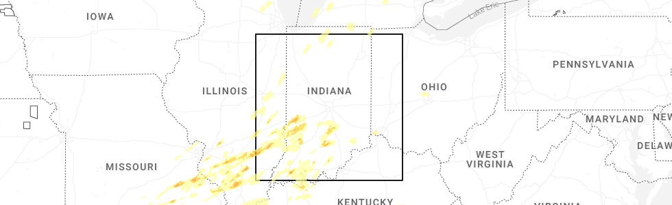
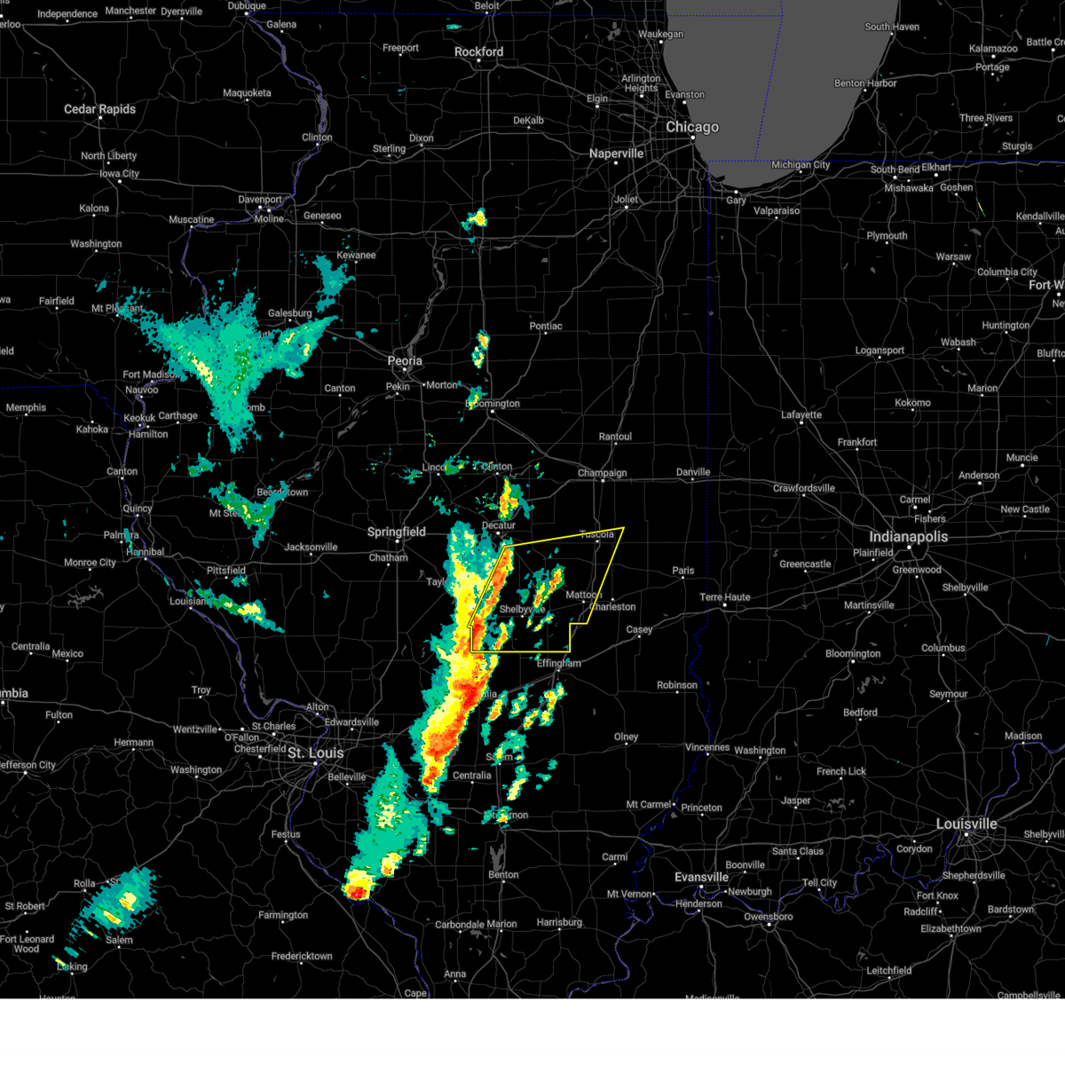
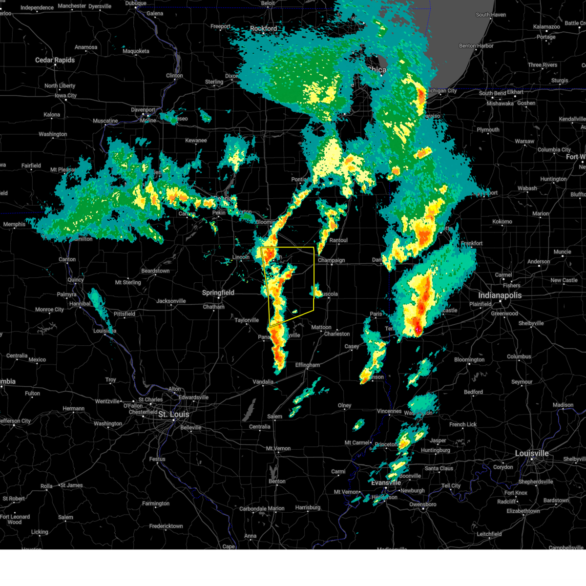
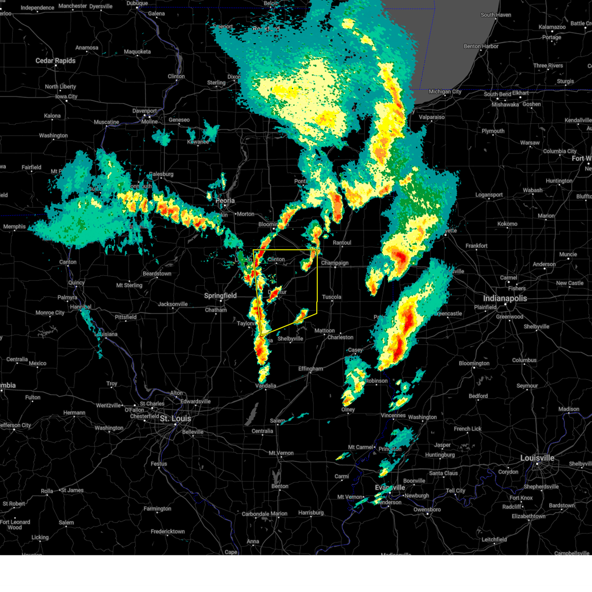
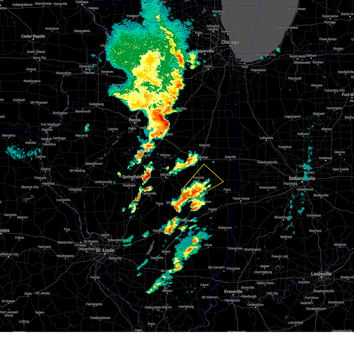
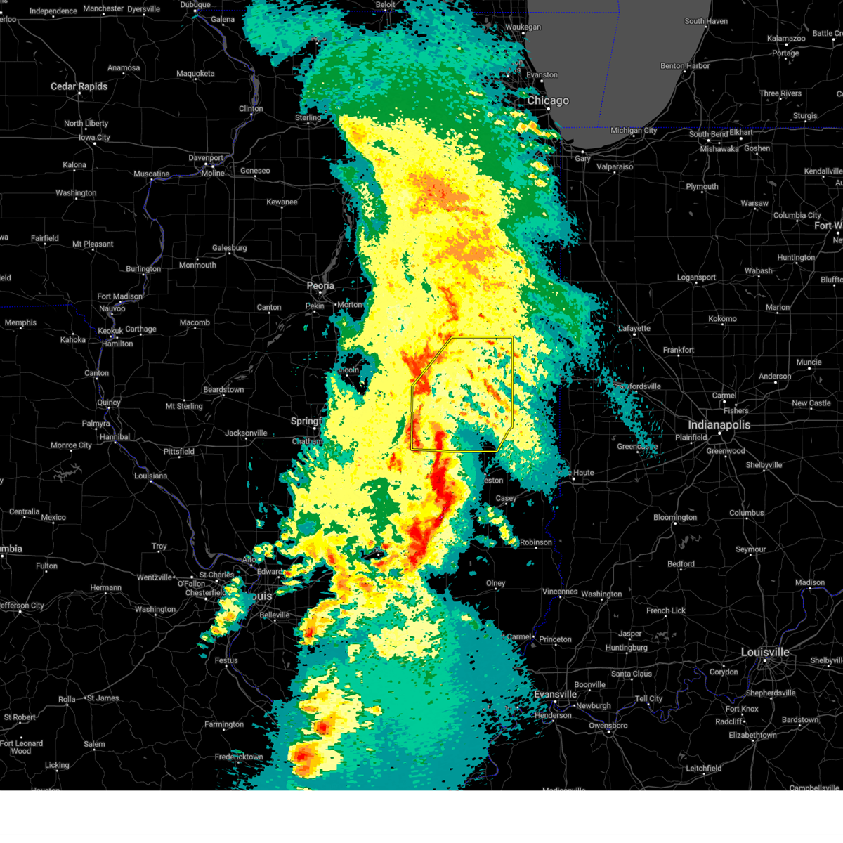
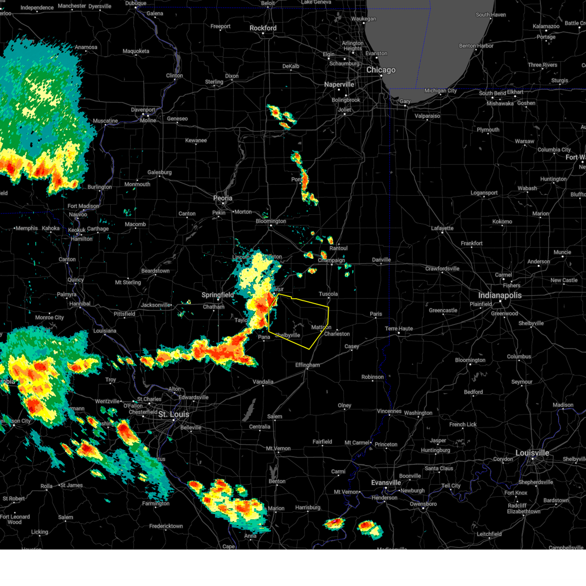
Hail Map for Arthur, IL
The Arthur, IL area has had 4 reports of on-the-ground hail by trained spotters, and has been under severe weather warnings 21 times during the past 12 months. Doppler radar has detected hail at or near Arthur, IL on 53 occasions, including 1 occasion during the past year.
| Name: | Arthur, IL |
| Where Located: | 17 miles NNW of Mattoon, IL |
| Map: | Google Map for Arthur, IL |
| Population: | 2288 |
| Housing Units: | 1029 |
| More Info: | Search Google for Arthur, IL |
2
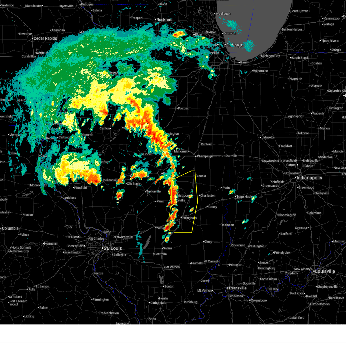
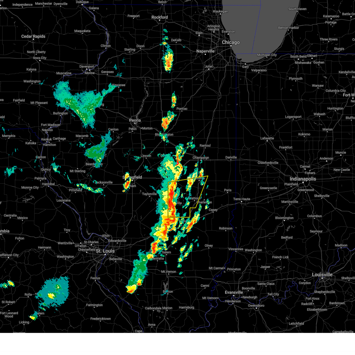
The Top Recent Hail Date for Arthur, IL is Sunday, March 30, 2025 (12th out of 53)
Hail and Wind Damage Spotted near Arthur, IL
| Date / Time | Report Details |
|---|---|
| 6/18/2025 12:30 PM CDT |
 Svrilx the national weather service in lincoln has issued a * severe thunderstorm warning for, coles county in east central illinois, west central edgar county in east central illinois, southeastern moultrie county in central illinois, northwestern jasper county in southeastern illinois, northwestern clark county in east central illinois, southeastern shelby county in central illinois, cumberland county in east central illinois, southeastern champaign county in east central illinois, douglas county in east central illinois, eastern effingham county in south central illinois, * until 100 pm cdt. * at 1230 pm cdt, severe thunderstorms were located along a line extending from near philo to charleston to near watson, moving northeast at 50 mph (radar indicated). Hazards include 60 mph wind gusts. Expect damage to roofs, siding, and trees. severe thunderstorms will be near, charleston, greenup, toledo, villa grove, oakland, ashmore, dieterich, camargo, jewett, and montrose around 1235 pm cdt. homer, newman, westfield, and broadlands around 1240 pm cdt. hidalgo around 1245 pm cdt. this includes the following highways, interstate 57 between mile markers 147 and 219. Interstate 70 between mile markers 89 and 126. Svrilx the national weather service in lincoln has issued a * severe thunderstorm warning for, coles county in east central illinois, west central edgar county in east central illinois, southeastern moultrie county in central illinois, northwestern jasper county in southeastern illinois, northwestern clark county in east central illinois, southeastern shelby county in central illinois, cumberland county in east central illinois, southeastern champaign county in east central illinois, douglas county in east central illinois, eastern effingham county in south central illinois, * until 100 pm cdt. * at 1230 pm cdt, severe thunderstorms were located along a line extending from near philo to charleston to near watson, moving northeast at 50 mph (radar indicated). Hazards include 60 mph wind gusts. Expect damage to roofs, siding, and trees. severe thunderstorms will be near, charleston, greenup, toledo, villa grove, oakland, ashmore, dieterich, camargo, jewett, and montrose around 1235 pm cdt. homer, newman, westfield, and broadlands around 1240 pm cdt. hidalgo around 1245 pm cdt. this includes the following highways, interstate 57 between mile markers 147 and 219. Interstate 70 between mile markers 89 and 126.
|
| 6/18/2025 12:05 PM CDT |
 Svrilx the national weather service in lincoln has issued a * severe thunderstorm warning for, western coles county in east central illinois, moultrie county in central illinois, northwestern jasper county in southeastern illinois, eastern shelby county in central illinois, southeastern piatt county in central illinois, western cumberland county in east central illinois, northwestern clay county in south central illinois, western douglas county in east central illinois, effingham county in south central illinois, * until 1230 pm cdt. * at 1204 pm cdt, severe thunderstorms were located along a line extending from near hammond to near neoga to near mason, moving northeast at 40 mph (radar indicated). Hazards include 60 mph wind gusts. Expect damage to roofs, siding, and trees. severe thunderstorms will be near, mattoon, effingham, neoga, arthur, teutopolis, atwood, watson, cooks mill, and heartville around 1210 pm cdt. humboldt and montrose around 1215 pm cdt. arcola, dieterich, and lerna around 1220 pm cdt. this includes the following highways, interstate 57 between mile markers 142 and 217. Interstate 70 between mile markers 79 and 112. Svrilx the national weather service in lincoln has issued a * severe thunderstorm warning for, western coles county in east central illinois, moultrie county in central illinois, northwestern jasper county in southeastern illinois, eastern shelby county in central illinois, southeastern piatt county in central illinois, western cumberland county in east central illinois, northwestern clay county in south central illinois, western douglas county in east central illinois, effingham county in south central illinois, * until 1230 pm cdt. * at 1204 pm cdt, severe thunderstorms were located along a line extending from near hammond to near neoga to near mason, moving northeast at 40 mph (radar indicated). Hazards include 60 mph wind gusts. Expect damage to roofs, siding, and trees. severe thunderstorms will be near, mattoon, effingham, neoga, arthur, teutopolis, atwood, watson, cooks mill, and heartville around 1210 pm cdt. humboldt and montrose around 1215 pm cdt. arcola, dieterich, and lerna around 1220 pm cdt. this includes the following highways, interstate 57 between mile markers 142 and 217. Interstate 70 between mile markers 79 and 112.
|
| 3/30/2025 1:11 PM CDT |
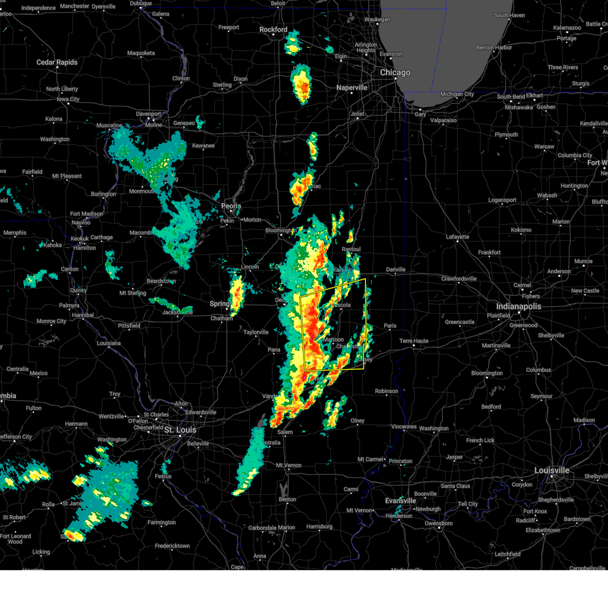 Svrilx the national weather service in lincoln has issued a * severe thunderstorm warning for, coles county in east central illinois, moultrie county in central illinois, eastern shelby county in central illinois, southern piatt county in central illinois, cumberland county in east central illinois, southern champaign county in east central illinois, douglas county in east central illinois, east central macon county in central illinois, * until 200 pm cdt. * at 111 pm cdt, severe thunderstorms were located along a line extending from near bement to near neoga, moving northeast at 55 mph (radar indicated). Hazards include 60 mph wind gusts and quarter size hail. Hail damage to vehicles is expected. expect wind damage to roofs, siding, and trees. severe thunderstorms will be near, cooks mill, ivesdale, arthur, mattoon, and atwood around 115 pm cdt. sadorus, arcola, and humboldt around 120 pm cdt. pesotum, tolono, and tuscola around 125 pm cdt. camargo around 130 pm cdt. other locations in the path of these severe thunderstorms include villa grove, philo, sidney, broadlands and newman. this includes the following highways, interstate 57 between mile markers 170 and 227. Interstate 70 between mile markers 116 and 119, and between mile markers 121 and 126. Svrilx the national weather service in lincoln has issued a * severe thunderstorm warning for, coles county in east central illinois, moultrie county in central illinois, eastern shelby county in central illinois, southern piatt county in central illinois, cumberland county in east central illinois, southern champaign county in east central illinois, douglas county in east central illinois, east central macon county in central illinois, * until 200 pm cdt. * at 111 pm cdt, severe thunderstorms were located along a line extending from near bement to near neoga, moving northeast at 55 mph (radar indicated). Hazards include 60 mph wind gusts and quarter size hail. Hail damage to vehicles is expected. expect wind damage to roofs, siding, and trees. severe thunderstorms will be near, cooks mill, ivesdale, arthur, mattoon, and atwood around 115 pm cdt. sadorus, arcola, and humboldt around 120 pm cdt. pesotum, tolono, and tuscola around 125 pm cdt. camargo around 130 pm cdt. other locations in the path of these severe thunderstorms include villa grove, philo, sidney, broadlands and newman. this includes the following highways, interstate 57 between mile markers 170 and 227. Interstate 70 between mile markers 116 and 119, and between mile markers 121 and 126.
|
| 3/30/2025 12:53 PM CDT |
 the severe thunderstorm warning has been cancelled and is no longer in effect the severe thunderstorm warning has been cancelled and is no longer in effect
|
| 3/30/2025 12:53 PM CDT |
 At 1252 pm cdt, severe thunderstorms were located along a line extending from near dalton city to near beecher city, moving east at 40 mph (radar indicated). Hazards include 60 mph wind gusts and quarter size hail. Hail damage to vehicles is expected. expect wind damage to roofs, siding, and trees. these severe storms will be near, sullivan, lovington, stewardson, and windsor around 100 pm cdt. allenville around 105 pm cdt. arthur around 110 pm cdt. cooks mill and mattoon around 115 pm cdt. atwood around 120 pm cdt. other locations impacted by these severe thunderstorms include trowbridge, etna, clarksburg, wolf creek state park, lake city, mode, strasburg, lakewood, chesterville, and hervey city. This includes interstate 57 between mile markers 169 and 172, and between mile markers 180 and 215. At 1252 pm cdt, severe thunderstorms were located along a line extending from near dalton city to near beecher city, moving east at 40 mph (radar indicated). Hazards include 60 mph wind gusts and quarter size hail. Hail damage to vehicles is expected. expect wind damage to roofs, siding, and trees. these severe storms will be near, sullivan, lovington, stewardson, and windsor around 100 pm cdt. allenville around 105 pm cdt. arthur around 110 pm cdt. cooks mill and mattoon around 115 pm cdt. atwood around 120 pm cdt. other locations impacted by these severe thunderstorms include trowbridge, etna, clarksburg, wolf creek state park, lake city, mode, strasburg, lakewood, chesterville, and hervey city. This includes interstate 57 between mile markers 169 and 172, and between mile markers 180 and 215.
|
| 3/30/2025 12:33 PM CDT |
 Svrilx the national weather service in lincoln has issued a * severe thunderstorm warning for, western coles county in east central illinois, southeastern christian county in central illinois, moultrie county in central illinois, shelby county in central illinois, southeastern piatt county in central illinois, western douglas county in east central illinois, southeastern macon county in central illinois, * until 115 pm cdt. * at 1233 pm cdt, severe thunderstorms were located along a line extending from dalton city to near herrick, moving east at 45 mph (radar indicated). Hazards include 60 mph wind gusts and quarter size hail. Hail damage to vehicles is expected. expect wind damage to roofs, siding, and trees. severe thunderstorms will be near, cowden, bethany, shelbyville, lovington, findlay, and herrick around 1240 pm cdt. sullivan and hammond around 1245 pm cdt. other locations in the path of these severe thunderstorms include allenville, arthur, atwood and windsor. This includes interstate 57 between mile markers 169 and 172, and between mile markers 180 and 215. Svrilx the national weather service in lincoln has issued a * severe thunderstorm warning for, western coles county in east central illinois, southeastern christian county in central illinois, moultrie county in central illinois, shelby county in central illinois, southeastern piatt county in central illinois, western douglas county in east central illinois, southeastern macon county in central illinois, * until 115 pm cdt. * at 1233 pm cdt, severe thunderstorms were located along a line extending from dalton city to near herrick, moving east at 45 mph (radar indicated). Hazards include 60 mph wind gusts and quarter size hail. Hail damage to vehicles is expected. expect wind damage to roofs, siding, and trees. severe thunderstorms will be near, cowden, bethany, shelbyville, lovington, findlay, and herrick around 1240 pm cdt. sullivan and hammond around 1245 pm cdt. other locations in the path of these severe thunderstorms include allenville, arthur, atwood and windsor. This includes interstate 57 between mile markers 169 and 172, and between mile markers 180 and 215.
|
| 3/19/2025 6:46 PM CDT |
 The storms which prompted the warning have moved out of the area. therefore, the warning has been allowed to expire. a tornado watch remains in effect until 900 pm cdt for central and east central illinois. The storms which prompted the warning have moved out of the area. therefore, the warning has been allowed to expire. a tornado watch remains in effect until 900 pm cdt for central and east central illinois.
|
| 3/19/2025 6:30 PM CDT |
 the severe thunderstorm warning has been cancelled and is no longer in effect the severe thunderstorm warning has been cancelled and is no longer in effect
|
| 3/19/2025 6:30 PM CDT |
 At 629 pm cdt, severe thunderstorms were located along a line extending from near le roy to de land to lovington, moving northeast at 50 mph (radar indicated). Hazards include 60 mph wind gusts and quarter size hail. Hail damage to vehicles is expected. expect wind damage to roofs, siding, and trees. these severe storms will be near, monticello, hammond, ivesdale, mansfield, white heath, bement, and atwood around 635 pm cdt. other locations impacted by these severe thunderstorms include milmine, cadwell, la place, lake city, de witt, galesville, and lodge. this includes the following highways, interstate 72 between mile markers 158 and 173. Interstate 74 between mile markers 156 and 168. At 629 pm cdt, severe thunderstorms were located along a line extending from near le roy to de land to lovington, moving northeast at 50 mph (radar indicated). Hazards include 60 mph wind gusts and quarter size hail. Hail damage to vehicles is expected. expect wind damage to roofs, siding, and trees. these severe storms will be near, monticello, hammond, ivesdale, mansfield, white heath, bement, and atwood around 635 pm cdt. other locations impacted by these severe thunderstorms include milmine, cadwell, la place, lake city, de witt, galesville, and lodge. this includes the following highways, interstate 72 between mile markers 158 and 173. Interstate 74 between mile markers 156 and 168.
|
| 3/19/2025 6:07 PM CDT |
 the severe thunderstorm warning has been cancelled and is no longer in effect the severe thunderstorm warning has been cancelled and is no longer in effect
|
| 3/19/2025 6:07 PM CDT |
 At 607 pm cdt, severe thunderstorms were located along a line extending from near wapella to near oreana to 6 miles southeast of moweaqua, moving northeast at 50 mph (radar indicated). Hazards include 60 mph wind gusts and quarter size hail. Hail damage to vehicles is expected. expect wind damage to roofs, siding, and trees. these severe storms will be near, oreana, wapella, mount zion, decatur airport, clinton, long creek, dalton city, decatur, and argenta around 610 pm cdt. cerro gordo, bethany, weldon, and cisco around 615 pm cdt. lovington around 620 pm cdt. de land, monticello, hammond, bement, and farmer city around 625 pm cdt. white heath around 630 pm cdt. ivesdale, mansfield, arthur, and atwood around 635 pm cdt. other locations impacted by these severe thunderstorms include clinton power station, weldon springs state park, lake city, lane, elwin, milmine, hervey city, cadwell, la place, and hallsville. this includes the following highways, interstate 72 between mile markers 136 and 173. Interstate 74 between mile markers 156 and 168. At 607 pm cdt, severe thunderstorms were located along a line extending from near wapella to near oreana to 6 miles southeast of moweaqua, moving northeast at 50 mph (radar indicated). Hazards include 60 mph wind gusts and quarter size hail. Hail damage to vehicles is expected. expect wind damage to roofs, siding, and trees. these severe storms will be near, oreana, wapella, mount zion, decatur airport, clinton, long creek, dalton city, decatur, and argenta around 610 pm cdt. cerro gordo, bethany, weldon, and cisco around 615 pm cdt. lovington around 620 pm cdt. de land, monticello, hammond, bement, and farmer city around 625 pm cdt. white heath around 630 pm cdt. ivesdale, mansfield, arthur, and atwood around 635 pm cdt. other locations impacted by these severe thunderstorms include clinton power station, weldon springs state park, lake city, lane, elwin, milmine, hervey city, cadwell, la place, and hallsville. this includes the following highways, interstate 72 between mile markers 136 and 173. Interstate 74 between mile markers 156 and 168.
|
| 3/19/2025 5:50 PM CDT |
 Svrilx the national weather service in lincoln has issued a * severe thunderstorm warning for, eastern logan county in central illinois, northeastern christian county in central illinois, northern moultrie county in central illinois, northwestern shelby county in central illinois, piatt county in central illinois, de witt county in central illinois, macon county in central illinois, * until 645 pm cdt. * at 549 pm cdt, severe thunderstorms were located along a line extending from near atlanta to near latham to near owaneco, moving northeast at 50 mph (radar indicated). Hazards include 60 mph wind gusts and quarter size hail. Hail damage to vehicles is expected. expect wind damage to roofs, siding, and trees. severe thunderstorms will be near, kenney, assumption, moweaqua, forsyth, clinton, warrensburg, macon, decatur, waynesville, and harristown around 555 pm cdt. wapella, mount zion, and maroa around 600 pm cdt. oreana, decatur airport, long creek, and argenta around 605 pm cdt. other locations in the path of these severe thunderstorms include bethany, dalton city, cerro gordo, weldon, cisco, de land, lovington, farmer city, monticello, hammond, bement, mansfield and white heath. this includes the following highways, interstate 55 between mile markers 139 and 141. interstate 72 between mile markers 126 and 173. Interstate 74 between mile markers 156 and 168. Svrilx the national weather service in lincoln has issued a * severe thunderstorm warning for, eastern logan county in central illinois, northeastern christian county in central illinois, northern moultrie county in central illinois, northwestern shelby county in central illinois, piatt county in central illinois, de witt county in central illinois, macon county in central illinois, * until 645 pm cdt. * at 549 pm cdt, severe thunderstorms were located along a line extending from near atlanta to near latham to near owaneco, moving northeast at 50 mph (radar indicated). Hazards include 60 mph wind gusts and quarter size hail. Hail damage to vehicles is expected. expect wind damage to roofs, siding, and trees. severe thunderstorms will be near, kenney, assumption, moweaqua, forsyth, clinton, warrensburg, macon, decatur, waynesville, and harristown around 555 pm cdt. wapella, mount zion, and maroa around 600 pm cdt. oreana, decatur airport, long creek, and argenta around 605 pm cdt. other locations in the path of these severe thunderstorms include bethany, dalton city, cerro gordo, weldon, cisco, de land, lovington, farmer city, monticello, hammond, bement, mansfield and white heath. this includes the following highways, interstate 55 between mile markers 139 and 141. interstate 72 between mile markers 126 and 173. Interstate 74 between mile markers 156 and 168.
|
| 3/19/2025 4:30 PM CDT | Power pole blown dow in coles county IL, 7.4 miles N of Arthur, IL |
| 3/19/2025 4:23 PM CDT |
 Svrilx the national weather service in lincoln has issued a * severe thunderstorm warning for, northwestern coles county in east central illinois, northwestern edgar county in east central illinois, east central moultrie county in central illinois, southeastern champaign county in east central illinois, douglas county in east central illinois, * until 515 pm cdt. * at 423 pm cdt, a severe thunderstorm was located near cooks mill, or 7 miles east of sullivan, moving northeast at 70 mph (radar indicated). Hazards include 70 mph wind gusts and quarter size hail. Hail damage to vehicles is expected. expect considerable tree damage. wind damage is also likely to mobile homes, roofs, and outbuildings. this severe thunderstorm will be near, arcola around 430 pm cdt. tuscola around 435 pm cdt. camargo and villa grove around 440 pm cdt. other locations in the path of this severe thunderstorm include broadlands. This includes interstate 57 between mile markers 194 and 222. Svrilx the national weather service in lincoln has issued a * severe thunderstorm warning for, northwestern coles county in east central illinois, northwestern edgar county in east central illinois, east central moultrie county in central illinois, southeastern champaign county in east central illinois, douglas county in east central illinois, * until 515 pm cdt. * at 423 pm cdt, a severe thunderstorm was located near cooks mill, or 7 miles east of sullivan, moving northeast at 70 mph (radar indicated). Hazards include 70 mph wind gusts and quarter size hail. Hail damage to vehicles is expected. expect considerable tree damage. wind damage is also likely to mobile homes, roofs, and outbuildings. this severe thunderstorm will be near, arcola around 430 pm cdt. tuscola around 435 pm cdt. camargo and villa grove around 440 pm cdt. other locations in the path of this severe thunderstorm include broadlands. This includes interstate 57 between mile markers 194 and 222.
|
| 3/15/2025 12:07 AM CDT | Torilx the national weather service in lincoln has issued a * tornado warning for, southern champaign county in east central illinois, western douglas county in east central illinois, * until 1245 am cdt. * at 1207 am cdt, a severe thunderstorm capable of producing a tornado was located near arthur, or near arcola, moving northeast at 55 mph (radar indicated rotation). Hazards include tornado and quarter size hail. Flying debris will be dangerous to those caught without shelter. mobile homes will be damaged or destroyed. damage to roofs, windows, and vehicles will occur. tree damage is likely. this dangerous storm will be near, tuscola around 1210 am cdt. villa grove and pesotum around 1220 am cdt. philo around 1225 am cdt. other locations in the path of this tornadic thunderstorm include sidney. this includes the following highways, interstate 57 between mile markers 206 and 237. interstate 72 between mile markers 181 and 182. Interstate 74 between mile markers 178 and 181. |
| 3/14/2025 11:54 PM CDT |
 Svrilx the national weather service in lincoln has issued a * severe thunderstorm warning for, northern moultrie county in central illinois, piatt county in central illinois, southeastern de witt county in central illinois, southeastern mclean county in central illinois, champaign county in east central illinois, douglas county in east central illinois, northeastern macon county in central illinois, * until 100 am cdt. * at 1153 pm cdt, severe thunderstorms were located along a line extending from near bement to near arthur to near mattoon, moving northeast at 65 mph (radar indicated). Hazards include 70 mph wind gusts. Expect considerable tree damage. damage is likely to mobile homes, roofs, and outbuildings. severe thunderstorms will be near, sadorus, arcola, monticello, ivesdale, white heath, atwood, and tuscola around 1200 am cdt. camargo, mahomet, savoy, willard airport, seymour, champaign, lake of the woods, pesotum, tolono, and bondville around 1205 am cdt. villa grove, philo, and urbana around 1210 am cdt. other locations in the path of these severe thunderstorms include broadlands, rantoul, st. joseph, sidney, thomasboro, homer, gifford and ogden. this includes the following highways, interstate 57 between mile markers 202 and 257. interstate 72 between mile markers 152 and 182. Interstate 74 between mile markers 160 and 197. Svrilx the national weather service in lincoln has issued a * severe thunderstorm warning for, northern moultrie county in central illinois, piatt county in central illinois, southeastern de witt county in central illinois, southeastern mclean county in central illinois, champaign county in east central illinois, douglas county in east central illinois, northeastern macon county in central illinois, * until 100 am cdt. * at 1153 pm cdt, severe thunderstorms were located along a line extending from near bement to near arthur to near mattoon, moving northeast at 65 mph (radar indicated). Hazards include 70 mph wind gusts. Expect considerable tree damage. damage is likely to mobile homes, roofs, and outbuildings. severe thunderstorms will be near, sadorus, arcola, monticello, ivesdale, white heath, atwood, and tuscola around 1200 am cdt. camargo, mahomet, savoy, willard airport, seymour, champaign, lake of the woods, pesotum, tolono, and bondville around 1205 am cdt. villa grove, philo, and urbana around 1210 am cdt. other locations in the path of these severe thunderstorms include broadlands, rantoul, st. joseph, sidney, thomasboro, homer, gifford and ogden. this includes the following highways, interstate 57 between mile markers 202 and 257. interstate 72 between mile markers 152 and 182. Interstate 74 between mile markers 160 and 197.
|
| 7/30/2024 3:48 PM CDT |
 Svrilx the national weather service in lincoln has issued a * severe thunderstorm warning for, western coles county in east central illinois, moultrie county in central illinois, central shelby county in central illinois, southwestern douglas county in east central illinois, southeastern macon county in central illinois, * until 430 pm cdt. * at 348 pm cdt, severe thunderstorms were located along a line extending from long creek to near dalton city to near moweaqua, moving east at 45 mph (radar indicated). Hazards include 60 mph wind gusts and quarter size hail. Hail damage to vehicles is expected. expect wind damage to roofs, siding, and trees. severe thunderstorms will be near, bethany and dalton city around 355 pm cdt. lovington and findlay around 400 pm cdt. sullivan around 405 pm cdt. other locations in the path of these severe thunderstorms include arthur, allenville, windsor, arcola and cooks mill. This includes interstate 57 between mile markers 193 and 205. Svrilx the national weather service in lincoln has issued a * severe thunderstorm warning for, western coles county in east central illinois, moultrie county in central illinois, central shelby county in central illinois, southwestern douglas county in east central illinois, southeastern macon county in central illinois, * until 430 pm cdt. * at 348 pm cdt, severe thunderstorms were located along a line extending from long creek to near dalton city to near moweaqua, moving east at 45 mph (radar indicated). Hazards include 60 mph wind gusts and quarter size hail. Hail damage to vehicles is expected. expect wind damage to roofs, siding, and trees. severe thunderstorms will be near, bethany and dalton city around 355 pm cdt. lovington and findlay around 400 pm cdt. sullivan around 405 pm cdt. other locations in the path of these severe thunderstorms include arthur, allenville, windsor, arcola and cooks mill. This includes interstate 57 between mile markers 193 and 205.
|
| 7/15/2024 10:15 PM CDT |
 the severe thunderstorm warning has been cancelled and is no longer in effect the severe thunderstorm warning has been cancelled and is no longer in effect
|
| 7/15/2024 10:15 PM CDT |
 At 1013 pm cdt, severe thunderstorms were located along a line extending from 7 miles north of fithian to near villa grove to near arthur, moving east at 70 mph (radar indicated). Hazards include 70 mph wind gusts. Expect considerable tree damage. damage is likely to mobile homes, roofs, and outbuildings. these severe storms will be near, arcola, homer, and camargo around 1020 pm cdt. other locations impacted by these severe thunderstorms include longview, lake city, dewey, ludlow, flatville, royal, chesterville, milmine, cadwell, and la place. this includes the following highways, interstate 57 between mile markers 203 and 257. interstate 72 between mile markers 160 and 182. Interstate 74 between mile markers 168 and 197. At 1013 pm cdt, severe thunderstorms were located along a line extending from 7 miles north of fithian to near villa grove to near arthur, moving east at 70 mph (radar indicated). Hazards include 70 mph wind gusts. Expect considerable tree damage. damage is likely to mobile homes, roofs, and outbuildings. these severe storms will be near, arcola, homer, and camargo around 1020 pm cdt. other locations impacted by these severe thunderstorms include longview, lake city, dewey, ludlow, flatville, royal, chesterville, milmine, cadwell, and la place. this includes the following highways, interstate 57 between mile markers 203 and 257. interstate 72 between mile markers 160 and 182. Interstate 74 between mile markers 168 and 197.
|
| 7/15/2024 9:43 PM CDT |
 the severe thunderstorm warning has been cancelled and is no longer in effect the severe thunderstorm warning has been cancelled and is no longer in effect
|
| 7/15/2024 9:43 PM CDT |
 At 941 pm cdt, severe thunderstorms were located along a line extending from gibson city to near farmer city to forsyth, moving east at 55 mph (radar indicated. several reports of 70 mph or higher winds have been observed with this line of storms). Hazards include 70 mph wind gusts and penny size hail. Expect considerable tree damage. damage is likely to mobile homes, roofs, and outbuildings. these severe storms will be near, decatur, monticello, mahomet, fisher, argenta, mansfield, oreana, de land, cisco, and white heath around 945 pm cdt. cerro gordo, bondville, seymour, decatur airport, and lake of the woods around 950 pm cdt. champaign, rantoul, bement, and thomasboro around 955 pm cdt. urbana, savoy, gifford, hammond, sadorus, ivesdale, and willard airport around 1000 pm cdt. tolono and atwood around 1005 pm cdt. st. joseph, philo, sidney, and pesotum around 1010 pm cdt. tuscola, villa grove, homer, and ogden around 1015 pm cdt. arcola and camargo around 1020 pm cdt. other locations impacted by these severe thunderstorms include clinton power station, longview, weldon springs state park, lake city, dewey, cooksville, ludlow, flatville, royal, and ellsworth. this includes the following highways, interstate 55 between mile markers 184 and 185. interstate 57 between mile markers 203 and 257. interstate 72 between mile markers 137 and 182. Interstate 74 between mile markers 143 and 197. At 941 pm cdt, severe thunderstorms were located along a line extending from gibson city to near farmer city to forsyth, moving east at 55 mph (radar indicated. several reports of 70 mph or higher winds have been observed with this line of storms). Hazards include 70 mph wind gusts and penny size hail. Expect considerable tree damage. damage is likely to mobile homes, roofs, and outbuildings. these severe storms will be near, decatur, monticello, mahomet, fisher, argenta, mansfield, oreana, de land, cisco, and white heath around 945 pm cdt. cerro gordo, bondville, seymour, decatur airport, and lake of the woods around 950 pm cdt. champaign, rantoul, bement, and thomasboro around 955 pm cdt. urbana, savoy, gifford, hammond, sadorus, ivesdale, and willard airport around 1000 pm cdt. tolono and atwood around 1005 pm cdt. st. joseph, philo, sidney, and pesotum around 1010 pm cdt. tuscola, villa grove, homer, and ogden around 1015 pm cdt. arcola and camargo around 1020 pm cdt. other locations impacted by these severe thunderstorms include clinton power station, longview, weldon springs state park, lake city, dewey, cooksville, ludlow, flatville, royal, and ellsworth. this includes the following highways, interstate 55 between mile markers 184 and 185. interstate 57 between mile markers 203 and 257. interstate 72 between mile markers 137 and 182. Interstate 74 between mile markers 143 and 197.
|
| 7/15/2024 9:11 PM CDT |
 Svrilx the national weather service in lincoln has issued a * severe thunderstorm warning for, northwestern coles county in east central illinois, east central logan county in central illinois, northern moultrie county in central illinois, piatt county in central illinois, de witt county in central illinois, west central vermilion county in east central illinois, eastern mclean county in central illinois, champaign county in east central illinois, douglas county in east central illinois, northern macon county in central illinois, * until 1030 pm cdt. * at 911 pm cdt, severe thunderstorms were located along a line extending from near lexington to 6 miles northwest of heyworth to lincoln, moving southeast at 60 mph. these are destructive storms (radar indicated). Hazards include 80 mph wind gusts and penny size hail. Flying debris will be dangerous to those caught without shelter. mobile homes will be heavily damaged. expect considerable damage to roofs, windows, and vehicles. extensive tree damage and power outages are likely. severe thunderstorms will be near, lexington, downs, chestnut, and beason around 915 pm cdt. clinton, le roy, colfax, wapella, and kenney around 920 pm cdt. maroa and latham around 925 pm cdt. forsyth, farmer city, warrensburg, saybrook, and weldon around 930 pm cdt. other locations in the path of these severe thunderstorms include decatur, argenta, oreana, de land, monticello, mahomet, fisher, long creek, mansfield, cisco, decatur airport, white heath, mount zion, cerro gordo, seymour, lake of the woods, champaign, rantoul, bement, thomasboro, bondville and ivesdale. this includes the following highways, interstate 55 between mile markers 173 and 187. interstate 57 between mile markers 203 and 257. interstate 72 between mile markers 137 and 182. Interstate 74 between mile markers 140 and 197. Svrilx the national weather service in lincoln has issued a * severe thunderstorm warning for, northwestern coles county in east central illinois, east central logan county in central illinois, northern moultrie county in central illinois, piatt county in central illinois, de witt county in central illinois, west central vermilion county in east central illinois, eastern mclean county in central illinois, champaign county in east central illinois, douglas county in east central illinois, northern macon county in central illinois, * until 1030 pm cdt. * at 911 pm cdt, severe thunderstorms were located along a line extending from near lexington to 6 miles northwest of heyworth to lincoln, moving southeast at 60 mph. these are destructive storms (radar indicated). Hazards include 80 mph wind gusts and penny size hail. Flying debris will be dangerous to those caught without shelter. mobile homes will be heavily damaged. expect considerable damage to roofs, windows, and vehicles. extensive tree damage and power outages are likely. severe thunderstorms will be near, lexington, downs, chestnut, and beason around 915 pm cdt. clinton, le roy, colfax, wapella, and kenney around 920 pm cdt. maroa and latham around 925 pm cdt. forsyth, farmer city, warrensburg, saybrook, and weldon around 930 pm cdt. other locations in the path of these severe thunderstorms include decatur, argenta, oreana, de land, monticello, mahomet, fisher, long creek, mansfield, cisco, decatur airport, white heath, mount zion, cerro gordo, seymour, lake of the woods, champaign, rantoul, bement, thomasboro, bondville and ivesdale. this includes the following highways, interstate 55 between mile markers 173 and 187. interstate 57 between mile markers 203 and 257. interstate 72 between mile markers 137 and 182. Interstate 74 between mile markers 140 and 197.
|
| 3/31/2024 8:35 PM CDT |
 The storm which prompted the warning has moved out of the area. therefore, the warning will be allowed to expire. The storm which prompted the warning has moved out of the area. therefore, the warning will be allowed to expire.
|
| 3/31/2024 8:34 PM CDT |
 At 834 pm cdt, a severe thunderstorm was located near arthur, or near arcola, moving southeast at 40 mph (radar indicated). Hazards include golf ball size hail and 60 mph wind gusts. People and animals outdoors will be injured. expect hail damage to roofs, siding, windows, and vehicles. expect wind damage to roofs, siding, and trees. this severe storm will be near, arcola and humboldt around 840 pm cdt. rardin around 855 pm cdt. ashmore around 900 pm cdt. other locations impacted by this severe thunderstorm include chesterville, murdock, coles county airport, fairgrange, walnut point state park, garrett, loxa, fox ridge state park, hindsboro, and bourbon. This includes interstate 57 between mile markers 188 and 213. At 834 pm cdt, a severe thunderstorm was located near arthur, or near arcola, moving southeast at 40 mph (radar indicated). Hazards include golf ball size hail and 60 mph wind gusts. People and animals outdoors will be injured. expect hail damage to roofs, siding, windows, and vehicles. expect wind damage to roofs, siding, and trees. this severe storm will be near, arcola and humboldt around 840 pm cdt. rardin around 855 pm cdt. ashmore around 900 pm cdt. other locations impacted by this severe thunderstorm include chesterville, murdock, coles county airport, fairgrange, walnut point state park, garrett, loxa, fox ridge state park, hindsboro, and bourbon. This includes interstate 57 between mile markers 188 and 213.
|
| 3/31/2024 8:34 PM CDT |
 the severe thunderstorm warning has been cancelled and is no longer in effect the severe thunderstorm warning has been cancelled and is no longer in effect
|
| 3/31/2024 8:31 PM CDT | Half Dollar sized hail reported 0.2 miles SSE of Arthur, IL |
| 3/31/2024 8:24 PM CDT |
 Svrilx the national weather service in lincoln has issued a * severe thunderstorm warning for, coles county in east central illinois, northeastern moultrie county in central illinois, southeastern piatt county in central illinois, douglas county in east central illinois, * until 930 pm cdt. * at 823 pm cdt, a severe thunderstorm was located near arthur, or 9 miles northeast of sullivan, moving southeast at 40 mph (broadcast media). Hazards include tennis ball size hail and 60 mph wind gusts. People and animals outdoors will be injured. expect hail damage to roofs, siding, windows, and vehicles. expect wind damage to roofs, siding, and trees. this severe thunderstorm will be near, arthur around 830 pm cdt. arcola around 835 pm cdt. humboldt around 840 pm cdt. other locations in the path of this severe thunderstorm include rardin and ashmore. This includes interstate 57 between mile markers 188 and 214. Svrilx the national weather service in lincoln has issued a * severe thunderstorm warning for, coles county in east central illinois, northeastern moultrie county in central illinois, southeastern piatt county in central illinois, douglas county in east central illinois, * until 930 pm cdt. * at 823 pm cdt, a severe thunderstorm was located near arthur, or 9 miles northeast of sullivan, moving southeast at 40 mph (broadcast media). Hazards include tennis ball size hail and 60 mph wind gusts. People and animals outdoors will be injured. expect hail damage to roofs, siding, windows, and vehicles. expect wind damage to roofs, siding, and trees. this severe thunderstorm will be near, arthur around 830 pm cdt. arcola around 835 pm cdt. humboldt around 840 pm cdt. other locations in the path of this severe thunderstorm include rardin and ashmore. This includes interstate 57 between mile markers 188 and 214.
|
| 3/31/2024 8:18 PM CDT |
 the severe thunderstorm warning has been cancelled and is no longer in effect the severe thunderstorm warning has been cancelled and is no longer in effect
|
| 3/31/2024 8:18 PM CDT |
 At 818 pm cdt, a severe thunderstorm was located over lovington, or 9 miles north of sullivan, moving southeast at 40 mph (broadcast media). Hazards include tennis ball size hail and 60 mph wind gusts. People and animals outdoors will be injured. expect hail damage to roofs, siding, windows, and vehicles. expect wind damage to roofs, siding, and trees. this severe storm will be near, arthur around 825 pm cdt. Other locations impacted by this severe thunderstorm include cadwell, la place, and lake city. At 818 pm cdt, a severe thunderstorm was located over lovington, or 9 miles north of sullivan, moving southeast at 40 mph (broadcast media). Hazards include tennis ball size hail and 60 mph wind gusts. People and animals outdoors will be injured. expect hail damage to roofs, siding, windows, and vehicles. expect wind damage to roofs, siding, and trees. this severe storm will be near, arthur around 825 pm cdt. Other locations impacted by this severe thunderstorm include cadwell, la place, and lake city.
|
| 3/31/2024 8:09 PM CDT |
 At 809 pm cdt, a severe thunderstorm was located near lovington, or 12 miles southeast of decatur, moving east at 40 mph (broadcast media). Hazards include tennis ball size hail and 60 mph wind gusts. People and animals outdoors will be injured. expect hail damage to roofs, siding, windows, and vehicles. expect wind damage to roofs, siding, and trees. this severe storm will be near, lovington and hammond around 815 pm cdt. arthur around 825 pm cdt. Other locations impacted by this severe thunderstorm include cadwell, la place, and lake city. At 809 pm cdt, a severe thunderstorm was located near lovington, or 12 miles southeast of decatur, moving east at 40 mph (broadcast media). Hazards include tennis ball size hail and 60 mph wind gusts. People and animals outdoors will be injured. expect hail damage to roofs, siding, windows, and vehicles. expect wind damage to roofs, siding, and trees. this severe storm will be near, lovington and hammond around 815 pm cdt. arthur around 825 pm cdt. Other locations impacted by this severe thunderstorm include cadwell, la place, and lake city.
|
| 3/31/2024 7:55 PM CDT |
 Svrilx the national weather service in lincoln has issued a * severe thunderstorm warning for, moultrie county in central illinois, southern piatt county in central illinois, southeastern macon county in central illinois, * until 845 pm cdt. * at 754 pm cdt, a severe thunderstorm was located over decatur airport, or near decatur, moving southeast at 40 mph (emergency management). Hazards include golf ball size hail and 60 mph wind gusts. People and animals outdoors will be injured. expect hail damage to roofs, siding, windows, and vehicles. expect wind damage to roofs, siding, and trees. this severe thunderstorm will be near, mount zion and long creek around 800 pm cdt. lovington around 810 pm cdt. other locations in the path of this severe thunderstorm include arthur. This includes interstate 72 between mile markers 141 and 147. Svrilx the national weather service in lincoln has issued a * severe thunderstorm warning for, moultrie county in central illinois, southern piatt county in central illinois, southeastern macon county in central illinois, * until 845 pm cdt. * at 754 pm cdt, a severe thunderstorm was located over decatur airport, or near decatur, moving southeast at 40 mph (emergency management). Hazards include golf ball size hail and 60 mph wind gusts. People and animals outdoors will be injured. expect hail damage to roofs, siding, windows, and vehicles. expect wind damage to roofs, siding, and trees. this severe thunderstorm will be near, mount zion and long creek around 800 pm cdt. lovington around 810 pm cdt. other locations in the path of this severe thunderstorm include arthur. This includes interstate 72 between mile markers 141 and 147.
|
| 3/14/2024 9:12 AM CDT |
 The storms which prompted the warning have weakened below severe limits, and have exited the warned area. therefore, the warning will be allowed to expire. however, gusty winds and heavy rain are still possible with these thunderstorms. a severe thunderstorm watch remains in effect until noon cdt for central illinois. The storms which prompted the warning have weakened below severe limits, and have exited the warned area. therefore, the warning will be allowed to expire. however, gusty winds and heavy rain are still possible with these thunderstorms. a severe thunderstorm watch remains in effect until noon cdt for central illinois.
|
| 3/14/2024 8:48 AM CDT |
 At 848 am cdt, severe thunderstorms were located along a line extending from near sullivan to near shelbyville, moving northeast at 45 mph (radar indicated). Hazards include 60 mph wind gusts and quarter size hail. Hail damage to vehicles is expected. expect wind damage to roofs, siding, and trees. these severe storms will be near, sullivan, windsor, and allenville around 855 am cdt. Other locations impacted by these severe thunderstorms include clarksburg, wolf creek state park, strasburg, cadwell, kirksville, and gays. At 848 am cdt, severe thunderstorms were located along a line extending from near sullivan to near shelbyville, moving northeast at 45 mph (radar indicated). Hazards include 60 mph wind gusts and quarter size hail. Hail damage to vehicles is expected. expect wind damage to roofs, siding, and trees. these severe storms will be near, sullivan, windsor, and allenville around 855 am cdt. Other locations impacted by these severe thunderstorms include clarksburg, wolf creek state park, strasburg, cadwell, kirksville, and gays.
|
| 3/14/2024 8:26 AM CDT |
 Svrilx the national weather service in lincoln has issued a * severe thunderstorm warning for, moultrie county in central illinois, central shelby county in central illinois, * until 915 am cdt. * at 826 am cdt, a severe thunderstorm was located over tower hill, or 8 miles east of pana, moving northeast at 40 mph (radar indicated). Hazards include 60 mph wind gusts and quarter size hail. Hail damage to vehicles is expected. expect wind damage to roofs, siding, and trees. this severe thunderstorm will be near, shelbyville around 830 am cdt. Other locations in the path of this severe thunderstorm include windsor and allenville. Svrilx the national weather service in lincoln has issued a * severe thunderstorm warning for, moultrie county in central illinois, central shelby county in central illinois, * until 915 am cdt. * at 826 am cdt, a severe thunderstorm was located over tower hill, or 8 miles east of pana, moving northeast at 40 mph (radar indicated). Hazards include 60 mph wind gusts and quarter size hail. Hail damage to vehicles is expected. expect wind damage to roofs, siding, and trees. this severe thunderstorm will be near, shelbyville around 830 am cdt. Other locations in the path of this severe thunderstorm include windsor and allenville.
|
| 8/25/2023 9:56 PM CDT |
 The severe thunderstorm warning for northwestern coles, southeastern moultrie, eastern shelby and southwestern douglas counties will expire at 1000 pm cdt, the storm which prompted the warning has weakened below severe limits, and no longer poses an immediate threat to life or property. therefore, the warning will be allowed to expire. a severe thunderstorm watch remains in effect until midnight cdt for central and east central illinois. to report severe weather, contact your nearest law enforcement agency. they will relay your report to the national weather service lincoln. remember, a severe thunderstorm warning still remains in effect for eastern douglas county until 1045 pm cdt. The severe thunderstorm warning for northwestern coles, southeastern moultrie, eastern shelby and southwestern douglas counties will expire at 1000 pm cdt, the storm which prompted the warning has weakened below severe limits, and no longer poses an immediate threat to life or property. therefore, the warning will be allowed to expire. a severe thunderstorm watch remains in effect until midnight cdt for central and east central illinois. to report severe weather, contact your nearest law enforcement agency. they will relay your report to the national weather service lincoln. remember, a severe thunderstorm warning still remains in effect for eastern douglas county until 1045 pm cdt.
|
| 8/25/2023 9:46 PM CDT |
 At 945 pm cdt, a severe thunderstorm was located near cooks mill, or 10 miles east of sullivan, moving southeast at 60 mph (radar indicated). Hazards include 60 mph wind gusts. Expect damage to roofs, siding, and trees. locations impacted include, shelbyville, sullivan, arcola, arthur, windsor, findlay, humboldt, allenville, westervelt, cooks mill, coles, bourbon, strasburg, gays, wolf creek state park, chesterville, cadwell, eagle creek state park and kirksville. this includes interstate 57 between mile markers 196 and 207. hail threat, radar indicated max hail size, <. 75 in wind threat, radar indicated max wind gust, 60 mph. At 945 pm cdt, a severe thunderstorm was located near cooks mill, or 10 miles east of sullivan, moving southeast at 60 mph (radar indicated). Hazards include 60 mph wind gusts. Expect damage to roofs, siding, and trees. locations impacted include, shelbyville, sullivan, arcola, arthur, windsor, findlay, humboldt, allenville, westervelt, cooks mill, coles, bourbon, strasburg, gays, wolf creek state park, chesterville, cadwell, eagle creek state park and kirksville. this includes interstate 57 between mile markers 196 and 207. hail threat, radar indicated max hail size, <. 75 in wind threat, radar indicated max wind gust, 60 mph.
|
| 8/25/2023 9:20 PM CDT |
 At 920 pm cdt, a severe thunderstorm was located over lovington, or 9 miles north of sullivan, moving east at 40 mph (radar indicated). Hazards include 60 mph wind gusts. Expect damage to roofs, siding, and trees. locations impacted include, arthur, atwood, cooks mill, arcola and humboldt. this includes interstate 57 between mile markers 196 and 207. hail threat, radar indicated max hail size, <. 75 in wind threat, radar indicated max wind gust, 60 mph. At 920 pm cdt, a severe thunderstorm was located over lovington, or 9 miles north of sullivan, moving east at 40 mph (radar indicated). Hazards include 60 mph wind gusts. Expect damage to roofs, siding, and trees. locations impacted include, arthur, atwood, cooks mill, arcola and humboldt. this includes interstate 57 between mile markers 196 and 207. hail threat, radar indicated max hail size, <. 75 in wind threat, radar indicated max wind gust, 60 mph.
|
| 8/25/2023 8:59 PM CDT |
 At 859 pm cdt, a severe thunderstorm was located over long creek, or near decatur, moving southeast at 45 mph (radar indicated). Hazards include 60 mph wind gusts and quarter size hail. Hail damage to vehicles is expected. expect wind damage to roofs, siding, and trees. this severe thunderstorm will be near, dalton city around 905 pm cdt. bethany, lovington and hammond around 915 pm cdt. other locations in the path of this severe thunderstorm include sullivan, arthur, allenville, cooks mill and humboldt. this includes the following highways, interstate 57 between mile markers 196 and 207. interstate 72 between mile markers 131 and 137, and between mile markers 141 and 147. hail threat, radar indicated max hail size, 1. 00 in wind threat, radar indicated max wind gust, 60 mph. At 859 pm cdt, a severe thunderstorm was located over long creek, or near decatur, moving southeast at 45 mph (radar indicated). Hazards include 60 mph wind gusts and quarter size hail. Hail damage to vehicles is expected. expect wind damage to roofs, siding, and trees. this severe thunderstorm will be near, dalton city around 905 pm cdt. bethany, lovington and hammond around 915 pm cdt. other locations in the path of this severe thunderstorm include sullivan, arthur, allenville, cooks mill and humboldt. this includes the following highways, interstate 57 between mile markers 196 and 207. interstate 72 between mile markers 131 and 137, and between mile markers 141 and 147. hail threat, radar indicated max hail size, 1. 00 in wind threat, radar indicated max wind gust, 60 mph.
|
| 7/25/2023 10:25 PM CDT | Tennis Ball sized hail reported 1.4 miles SW of Arthur, IL, delayed report. relayed via broadcast media. |
| 7/25/2023 10:10 PM CDT |
 At 1009 pm cdt, a severe thunderstorm was located near findlay, or near shelbyville, moving east at 15 mph (radar indicated). Hazards include ping pong ball size hail and 60 mph wind gusts. People and animals outdoors will be injured. expect hail damage to roofs, siding, windows, and vehicles. expect wind damage to roofs, siding, and trees. locations impacted include, windsor, sullivan, mattoon and allenville. this includes interstate 57 between mile markers 181 and 185. hail threat, radar indicated max hail size, 1. 50 in wind threat, radar indicated max wind gust, 60 mph. At 1009 pm cdt, a severe thunderstorm was located near findlay, or near shelbyville, moving east at 15 mph (radar indicated). Hazards include ping pong ball size hail and 60 mph wind gusts. People and animals outdoors will be injured. expect hail damage to roofs, siding, windows, and vehicles. expect wind damage to roofs, siding, and trees. locations impacted include, windsor, sullivan, mattoon and allenville. this includes interstate 57 between mile markers 181 and 185. hail threat, radar indicated max hail size, 1. 50 in wind threat, radar indicated max wind gust, 60 mph.
|
| 7/25/2023 9:43 PM CDT |
 At 943 pm cdt, a severe thunderstorm was located over westervelt, or near shelbyville, moving east at 20 mph (radar indicated). Hazards include ping pong ball size hail and 60 mph wind gusts. People and animals outdoors will be injured. expect hail damage to roofs, siding, windows, and vehicles. expect wind damage to roofs, siding, and trees. this severe thunderstorm will be near, findlay around 955 pm cdt. other locations in the path of this severe thunderstorm include windsor, sullivan, allenville and cooks mill. this includes interstate 57 between mile markers 181 and 185. hail threat, radar indicated max hail size, 1. 50 in wind threat, radar indicated max wind gust, 60 mph. At 943 pm cdt, a severe thunderstorm was located over westervelt, or near shelbyville, moving east at 20 mph (radar indicated). Hazards include ping pong ball size hail and 60 mph wind gusts. People and animals outdoors will be injured. expect hail damage to roofs, siding, windows, and vehicles. expect wind damage to roofs, siding, and trees. this severe thunderstorm will be near, findlay around 955 pm cdt. other locations in the path of this severe thunderstorm include windsor, sullivan, allenville and cooks mill. this includes interstate 57 between mile markers 181 and 185. hail threat, radar indicated max hail size, 1. 50 in wind threat, radar indicated max wind gust, 60 mph.
|
| 7/25/2023 9:36 PM CDT |
 At 936 pm cdt, a severe thunderstorm was located over lovington, or 9 miles north of sullivan, moving east at 20 mph (radar indicated). Hazards include 60 mph wind gusts and half dollar size hail. Hail damage to vehicles is expected. expect wind damage to roofs, siding, and trees. this severe thunderstorm will be near, hammond around 945 pm cdt. arthur around 955 pm cdt. other locations in the path of this severe thunderstorm include atwood. hail threat, radar indicated max hail size, 1. 25 in wind threat, radar indicated max wind gust, 60 mph. At 936 pm cdt, a severe thunderstorm was located over lovington, or 9 miles north of sullivan, moving east at 20 mph (radar indicated). Hazards include 60 mph wind gusts and half dollar size hail. Hail damage to vehicles is expected. expect wind damage to roofs, siding, and trees. this severe thunderstorm will be near, hammond around 945 pm cdt. arthur around 955 pm cdt. other locations in the path of this severe thunderstorm include atwood. hail threat, radar indicated max hail size, 1. 25 in wind threat, radar indicated max wind gust, 60 mph.
|
| 7/25/2023 9:23 PM CDT |
 At 923 pm cdt, a severe thunderstorm was located over findlay, or 8 miles southwest of sullivan, moving east at 20 mph (radar indicated). Hazards include ping pong ball size hail and 60 mph wind gusts. People and animals outdoors will be injured. expect hail damage to roofs, siding, windows, and vehicles. expect wind damage to roofs, siding, and trees. locations impacted include, sullivan, windsor and allenville. hail threat, radar indicated max hail size, 1. 50 in wind threat, radar indicated max wind gust, 60 mph. At 923 pm cdt, a severe thunderstorm was located over findlay, or 8 miles southwest of sullivan, moving east at 20 mph (radar indicated). Hazards include ping pong ball size hail and 60 mph wind gusts. People and animals outdoors will be injured. expect hail damage to roofs, siding, windows, and vehicles. expect wind damage to roofs, siding, and trees. locations impacted include, sullivan, windsor and allenville. hail threat, radar indicated max hail size, 1. 50 in wind threat, radar indicated max wind gust, 60 mph.
|
| 7/25/2023 9:15 PM CDT |
 At 915 pm cdt, a severe thunderstorm was located near findlay, or 8 miles north of shelbyville, moving east at 20 mph (radar indicated). Hazards include 60 mph wind gusts and quarter size hail. Hail damage to vehicles is expected. expect wind damage to roofs, siding, and trees. this severe thunderstorm will be near, findlay around 920 pm cdt. other locations in the path of this severe thunderstorm include sullivan, windsor and allenville. hail threat, radar indicated max hail size, 1. 00 in wind threat, radar indicated max wind gust, 60 mph. At 915 pm cdt, a severe thunderstorm was located near findlay, or 8 miles north of shelbyville, moving east at 20 mph (radar indicated). Hazards include 60 mph wind gusts and quarter size hail. Hail damage to vehicles is expected. expect wind damage to roofs, siding, and trees. this severe thunderstorm will be near, findlay around 920 pm cdt. other locations in the path of this severe thunderstorm include sullivan, windsor and allenville. hail threat, radar indicated max hail size, 1. 00 in wind threat, radar indicated max wind gust, 60 mph.
|
| 6/29/2023 1:16 PM CDT |
 At 114 pm cdt, severe thunderstorms were located along a line extending from near lake of the woods to near tuscola to near windsor, moving east at 80 mph. these are destructive storms for champaign and tuscola (emergency management). Hazards include 80 mph wind gusts and half dollar size hail. Flying debris will be dangerous to those caught without shelter. mobile homes will be heavily damaged. expect considerable damage to roofs, windows, and vehicles. extensive tree damage and power outages are likely. locations impacted include, champaign, urbana, villa grove, thomasboro, camargo, toledo, st. joseph, gifford, janesville, newman, ogden, broadlands and allerton. this includes the following highways, interstate 57 between mile markers 168 and 249. interstate 70 between mile markers 108 and 124. interstate 72 between mile markers 153 and 182. Interstate 74 between mile markers 159 and 200. At 114 pm cdt, severe thunderstorms were located along a line extending from near lake of the woods to near tuscola to near windsor, moving east at 80 mph. these are destructive storms for champaign and tuscola (emergency management). Hazards include 80 mph wind gusts and half dollar size hail. Flying debris will be dangerous to those caught without shelter. mobile homes will be heavily damaged. expect considerable damage to roofs, windows, and vehicles. extensive tree damage and power outages are likely. locations impacted include, champaign, urbana, villa grove, thomasboro, camargo, toledo, st. joseph, gifford, janesville, newman, ogden, broadlands and allerton. this includes the following highways, interstate 57 between mile markers 168 and 249. interstate 70 between mile markers 108 and 124. interstate 72 between mile markers 153 and 182. Interstate 74 between mile markers 159 and 200.
|
| 6/29/2023 12:51 PM CDT |
 At 1250 pm cdt, severe thunderstorms were located along a line extending from near wapella to near pana, moving east at 65 mph. these are destructive storms for eastern de witt and northern piatt county (radar indicated). Hazards include 80 mph wind gusts and half dollar size hail. Flying debris will be dangerous to those caught without shelter. mobile homes will be heavily damaged. expect considerable damage to roofs, windows, and vehicles. extensive tree damage and power outages are likely. severe thunderstorms will be near, weldon around 1255 pm cdt. farmer city and de land around 100 pm cdt. shelbyville and cowden around 105 pm cdt. mansfield and seymour around 110 pm cdt. other locations in the path of these severe thunderstorms include mahomet, fisher, windsor, stewardson, bondville, lake of the woods, champaign, urbana, mattoon, rantoul, neoga, thomasboro, toledo, st. joseph, gifford, lerna and janesville. this includes the following highways, interstate 57 between mile markers 168 and 250. interstate 70 between mile markers 108 and 124. interstate 72 between mile markers 133 and 182. Interstate 74 between mile markers 155 and 200. At 1250 pm cdt, severe thunderstorms were located along a line extending from near wapella to near pana, moving east at 65 mph. these are destructive storms for eastern de witt and northern piatt county (radar indicated). Hazards include 80 mph wind gusts and half dollar size hail. Flying debris will be dangerous to those caught without shelter. mobile homes will be heavily damaged. expect considerable damage to roofs, windows, and vehicles. extensive tree damage and power outages are likely. severe thunderstorms will be near, weldon around 1255 pm cdt. farmer city and de land around 100 pm cdt. shelbyville and cowden around 105 pm cdt. mansfield and seymour around 110 pm cdt. other locations in the path of these severe thunderstorms include mahomet, fisher, windsor, stewardson, bondville, lake of the woods, champaign, urbana, mattoon, rantoul, neoga, thomasboro, toledo, st. joseph, gifford, lerna and janesville. this includes the following highways, interstate 57 between mile markers 168 and 250. interstate 70 between mile markers 108 and 124. interstate 72 between mile markers 133 and 182. Interstate 74 between mile markers 155 and 200.
|
| 4/20/2023 6:55 PM CDT |
 At 655 pm cdt, severe thunderstorms were located along a line extending from near cerro gordo to near macon, moving northeast at 55 mph (radar indicated). Hazards include 60 mph wind gusts and quarter size hail. Hail damage to vehicles is expected. expect wind damage to roofs, siding, and trees. these severe storms will be near, cerro gordo around 700 pm cdt. other locations in the path of these severe thunderstorms include monticello, hammond and bement. this includes interstate 72 between mile markers 148 and 150. hail threat, radar indicated max hail size, 1. 00 in wind threat, radar indicated max wind gust, 60 mph. At 655 pm cdt, severe thunderstorms were located along a line extending from near cerro gordo to near macon, moving northeast at 55 mph (radar indicated). Hazards include 60 mph wind gusts and quarter size hail. Hail damage to vehicles is expected. expect wind damage to roofs, siding, and trees. these severe storms will be near, cerro gordo around 700 pm cdt. other locations in the path of these severe thunderstorms include monticello, hammond and bement. this includes interstate 72 between mile markers 148 and 150. hail threat, radar indicated max hail size, 1. 00 in wind threat, radar indicated max wind gust, 60 mph.
|
| 4/20/2023 6:48 PM CDT |
 At 648 pm cdt, severe thunderstorms were located along a line extending from long creek to near moweaqua, moving northeast at 55 mph (radar indicated). Hazards include 60 mph wind gusts and quarter size hail. Hail damage to vehicles is expected. expect wind damage to roofs, siding, and trees. these severe storms will be near, cerro gordo around 655 pm cdt. other locations in the path of these severe thunderstorms include bement, lovington, monticello and hammond. this includes interstate 72 between mile markers 147 and 150. hail threat, radar indicated max hail size, 1. 00 in wind threat, radar indicated max wind gust, 60 mph. At 648 pm cdt, severe thunderstorms were located along a line extending from long creek to near moweaqua, moving northeast at 55 mph (radar indicated). Hazards include 60 mph wind gusts and quarter size hail. Hail damage to vehicles is expected. expect wind damage to roofs, siding, and trees. these severe storms will be near, cerro gordo around 655 pm cdt. other locations in the path of these severe thunderstorms include bement, lovington, monticello and hammond. this includes interstate 72 between mile markers 147 and 150. hail threat, radar indicated max hail size, 1. 00 in wind threat, radar indicated max wind gust, 60 mph.
|
| 4/20/2023 6:35 PM CDT |
 At 635 pm cdt, severe thunderstorms were located along a line extending from near macon to near stonington, moving northeast at 55 mph (radar indicated). Hazards include 60 mph wind gusts and quarter size hail. Hail damage to vehicles is expected. expect wind damage to roofs, siding, and trees. severe thunderstorms will be near, harristown around 640 pm cdt. decatur and mount zion around 645 pm cdt. macon around 650 pm cdt. oreana around 655 pm cdt. other locations in the path of these severe thunderstorms include long creek, dalton city, monticello, cerro gordo and bement. this includes interstate 72 between mile markers 144 and 150. hail threat, radar indicated max hail size, 1. 00 in wind threat, radar indicated max wind gust, 60 mph. At 635 pm cdt, severe thunderstorms were located along a line extending from near macon to near stonington, moving northeast at 55 mph (radar indicated). Hazards include 60 mph wind gusts and quarter size hail. Hail damage to vehicles is expected. expect wind damage to roofs, siding, and trees. severe thunderstorms will be near, harristown around 640 pm cdt. decatur and mount zion around 645 pm cdt. macon around 650 pm cdt. oreana around 655 pm cdt. other locations in the path of these severe thunderstorms include long creek, dalton city, monticello, cerro gordo and bement. this includes interstate 72 between mile markers 144 and 150. hail threat, radar indicated max hail size, 1. 00 in wind threat, radar indicated max wind gust, 60 mph.
|
| 2/22/2023 10:20 AM CST |
 At 1020 am cst, a severe thunderstorm was located near windsor, or near sullivan, moving northeast at 55 mph (radar indicated). Hazards include quarter size hail. Damage to vehicles is expected. this severe storm will be near, allenville around 1025 am cst. hail threat, radar indicated max hail size, 1. 00 in wind threat, radar indicated max wind gust, <50 mph. At 1020 am cst, a severe thunderstorm was located near windsor, or near sullivan, moving northeast at 55 mph (radar indicated). Hazards include quarter size hail. Damage to vehicles is expected. this severe storm will be near, allenville around 1025 am cst. hail threat, radar indicated max hail size, 1. 00 in wind threat, radar indicated max wind gust, <50 mph.
|
| 2/22/2023 10:06 AM CST |
 At 1006 am cst, a severe thunderstorm was located over shelbyville, moving northeast at 55 mph (radar indicated). Hazards include quarter size hail. Damage to vehicles is expected. this severe thunderstorm will be near, findlay around 1015 am cst. sullivan and allenville around 1025 am cst. hail threat, radar indicated max hail size, 1. 00 in wind threat, radar indicated max wind gust, <50 mph. At 1006 am cst, a severe thunderstorm was located over shelbyville, moving northeast at 55 mph (radar indicated). Hazards include quarter size hail. Damage to vehicles is expected. this severe thunderstorm will be near, findlay around 1015 am cst. sullivan and allenville around 1025 am cst. hail threat, radar indicated max hail size, 1. 00 in wind threat, radar indicated max wind gust, <50 mph.
|
| 2/22/2023 9:47 AM CST |
 At 947 am cst, a severe thunderstorm was located near assumption, or 12 miles northwest of shelbyville, moving northeast at 50 mph (radar indicated). Hazards include quarter size hail. Damage to vehicles is expected. this severe thunderstorm will be near, findlay around 1000 am cst. bethany around 1005 am cst. other locations in the path of this severe thunderstorm include sullivan, lovington, allenville and arthur. hail threat, radar indicated max hail size, 1. 00 in wind threat, radar indicated max wind gust, <50 mph. At 947 am cst, a severe thunderstorm was located near assumption, or 12 miles northwest of shelbyville, moving northeast at 50 mph (radar indicated). Hazards include quarter size hail. Damage to vehicles is expected. this severe thunderstorm will be near, findlay around 1000 am cst. bethany around 1005 am cst. other locations in the path of this severe thunderstorm include sullivan, lovington, allenville and arthur. hail threat, radar indicated max hail size, 1. 00 in wind threat, radar indicated max wind gust, <50 mph.
|
| 8/29/2022 8:45 PM CDT |
 At 844 pm cdt, severe thunderstorms were located along a line extending from near tuscola to near arcola to near allenville, moving southeast at 30 mph (radar indicated). Hazards include 60 mph wind gusts. Expect damage to roofs, siding, and trees. locations impacted include, humboldt, mattoon, charleston, oakland and rardin. this includes interstate 57 between mile markers 188 and 201. hail threat, radar indicated max hail size, <. 75 in wind threat, radar indicated max wind gust, 60 mph. At 844 pm cdt, severe thunderstorms were located along a line extending from near tuscola to near arcola to near allenville, moving southeast at 30 mph (radar indicated). Hazards include 60 mph wind gusts. Expect damage to roofs, siding, and trees. locations impacted include, humboldt, mattoon, charleston, oakland and rardin. this includes interstate 57 between mile markers 188 and 201. hail threat, radar indicated max hail size, <. 75 in wind threat, radar indicated max wind gust, 60 mph.
|
| 8/29/2022 8:28 PM CDT |
 At 828 pm cdt, severe thunderstorms were located along a line extending from near atwood to near arthur to near bethany, moving east at 35 mph (radar indicated). Hazards include 60 mph wind gusts and penny size hail. Expect damage to roofs, siding, and trees. severe thunderstorms will be near, arthur around 835 pm cdt. humboldt around 845 pm cdt. other locations in the path of these severe thunderstorms include mattoon, cooks mill, charleston, oakland and rardin. this includes interstate 57 between mile markers 188 and 201. hail threat, radar indicated max hail size, 0. 75 in wind threat, radar indicated max wind gust, 60 mph. At 828 pm cdt, severe thunderstorms were located along a line extending from near atwood to near arthur to near bethany, moving east at 35 mph (radar indicated). Hazards include 60 mph wind gusts and penny size hail. Expect damage to roofs, siding, and trees. severe thunderstorms will be near, arthur around 835 pm cdt. humboldt around 845 pm cdt. other locations in the path of these severe thunderstorms include mattoon, cooks mill, charleston, oakland and rardin. this includes interstate 57 between mile markers 188 and 201. hail threat, radar indicated max hail size, 0. 75 in wind threat, radar indicated max wind gust, 60 mph.
|
| 8/29/2022 8:17 PM CDT |
 At 816 pm cdt, severe thunderstorms were located along a line extending from pesotum to near tuscola to near arthur, moving east at 40 mph (radar indicated). Hazards include 60 mph wind gusts and nickel size hail. Expect damage to roofs, siding, and trees. severe thunderstorms will be near, tuscola around 825 pm cdt. arcola and villa grove around 830 pm cdt. camargo around 835 pm cdt. other locations in the path of these severe thunderstorms include hindsboro and newman. this includes interstate 57 between mile markers 202 and 217. hail threat, radar indicated max hail size, 0. 88 in wind threat, radar indicated max wind gust, 60 mph. At 816 pm cdt, severe thunderstorms were located along a line extending from pesotum to near tuscola to near arthur, moving east at 40 mph (radar indicated). Hazards include 60 mph wind gusts and nickel size hail. Expect damage to roofs, siding, and trees. severe thunderstorms will be near, tuscola around 825 pm cdt. arcola and villa grove around 830 pm cdt. camargo around 835 pm cdt. other locations in the path of these severe thunderstorms include hindsboro and newman. this includes interstate 57 between mile markers 202 and 217. hail threat, radar indicated max hail size, 0. 88 in wind threat, radar indicated max wind gust, 60 mph.
|
| 8/3/2022 4:52 PM CDT |
 The severe thunderstorm warning for northern coles, northwestern edgar, east central moultrie, southwestern vermilion, southeastern champaign and douglas counties will expire at 500 pm cdt, the storms which prompted the warning have weakened below severe limits, and no longer pose an immediate threat to life or property. therefore, the warning will be allowed to expire. however small hail, gusty winds and heavy rain are still possible with these thunderstorms. a severe thunderstorm watch remains in effect until 900 pm cdt for central and east central illinois. The severe thunderstorm warning for northern coles, northwestern edgar, east central moultrie, southwestern vermilion, southeastern champaign and douglas counties will expire at 500 pm cdt, the storms which prompted the warning have weakened below severe limits, and no longer pose an immediate threat to life or property. therefore, the warning will be allowed to expire. however small hail, gusty winds and heavy rain are still possible with these thunderstorms. a severe thunderstorm watch remains in effect until 900 pm cdt for central and east central illinois.
|
| 8/3/2022 4:42 PM CDT |
 At 442 pm cdt, severe thunderstorms were located along a line extending from near fairmount to near arcola, moving east at 60 mph (radar indicated). Hazards include 60 mph wind gusts and penny size hail. Expect damage to roofs, siding, and trees. locations impacted include, homer, fairmount, sidell, catlin, oakland, newman, brocton and hume. this includes interstate 57 between mile markers 199 and 222. hail threat, radar indicated max hail size, 0. 75 in wind threat, radar indicated max wind gust, 60 mph. At 442 pm cdt, severe thunderstorms were located along a line extending from near fairmount to near arcola, moving east at 60 mph (radar indicated). Hazards include 60 mph wind gusts and penny size hail. Expect damage to roofs, siding, and trees. locations impacted include, homer, fairmount, sidell, catlin, oakland, newman, brocton and hume. this includes interstate 57 between mile markers 199 and 222. hail threat, radar indicated max hail size, 0. 75 in wind threat, radar indicated max wind gust, 60 mph.
|
| 8/3/2022 4:19 PM CDT |
 At 418 pm cdt, severe thunderstorms were located along a line extending from philo to near lovington, moving east at 40 mph (radar indicated). Hazards include 60 mph wind gusts and penny size hail. Expect damage to roofs, siding, and trees. severe thunderstorms will be near, philo and sidney around 425 pm cdt. broadlands around 430 pm cdt. homer and allerton around 435 pm cdt. other locations in the path of these severe thunderstorms include arcola, humboldt, fairmount, sidell, catlin, hindsboro, rardin and oakland. this includes interstate 57 between mile markers 198 and 229. hail threat, radar indicated max hail size, 0. 75 in wind threat, radar indicated max wind gust, 60 mph. At 418 pm cdt, severe thunderstorms were located along a line extending from philo to near lovington, moving east at 40 mph (radar indicated). Hazards include 60 mph wind gusts and penny size hail. Expect damage to roofs, siding, and trees. severe thunderstorms will be near, philo and sidney around 425 pm cdt. broadlands around 430 pm cdt. homer and allerton around 435 pm cdt. other locations in the path of these severe thunderstorms include arcola, humboldt, fairmount, sidell, catlin, hindsboro, rardin and oakland. this includes interstate 57 between mile markers 198 and 229. hail threat, radar indicated max hail size, 0. 75 in wind threat, radar indicated max wind gust, 60 mph.
|
| 8/3/2022 4:08 PM CDT |
 At 407 pm cdt, severe thunderstorms were located along a line extending from tolono to near lovington, moving east at 35 mph (radar indicated). Hazards include 70 mph wind gusts and penny size hail. Expect considerable tree damage. damage is likely to mobile homes, roofs, and outbuildings. locations impacted include, champaign, decatur, monticello, savoy, mount zion, tolono, arthur, bement, philo, cerro gordo, long creek, atwood, macon, lovington, pesotum, dalton city, hammond, oakley, sadorus and ivesdale. this includes the following highways, interstate 57 between mile markers 220 and 231. interstate 72 between mile markers 161 and 168. thunderstorm damage threat, considerable hail threat, radar indicated max hail size, 0. 75 in wind threat, radar indicated max wind gust, 70 mph. At 407 pm cdt, severe thunderstorms were located along a line extending from tolono to near lovington, moving east at 35 mph (radar indicated). Hazards include 70 mph wind gusts and penny size hail. Expect considerable tree damage. damage is likely to mobile homes, roofs, and outbuildings. locations impacted include, champaign, decatur, monticello, savoy, mount zion, tolono, arthur, bement, philo, cerro gordo, long creek, atwood, macon, lovington, pesotum, dalton city, hammond, oakley, sadorus and ivesdale. this includes the following highways, interstate 57 between mile markers 220 and 231. interstate 72 between mile markers 161 and 168. thunderstorm damage threat, considerable hail threat, radar indicated max hail size, 0. 75 in wind threat, radar indicated max wind gust, 70 mph.
|
| 8/3/2022 3:53 PM CDT |
 At 353 pm cdt, severe thunderstorms were located along a line extending from near monticello to near mount zion, moving east at 30 mph (radar indicated). Hazards include 70 mph wind gusts and penny size hail. Expect considerable tree damage. damage is likely to mobile homes, roofs, and outbuildings. locations impacted include, tolono, pesotum, savoy, lovington, hammond, arthur, philo and atwood. this includes the following highways, interstate 57 between mile markers 220 and 232. interstate 72 between mile markers 144 and 153, and between mile markers 156 and 168. thunderstorm damage threat, considerable hail threat, radar indicated max hail size, 0. 75 in wind threat, radar indicated max wind gust, 70 mph. At 353 pm cdt, severe thunderstorms were located along a line extending from near monticello to near mount zion, moving east at 30 mph (radar indicated). Hazards include 70 mph wind gusts and penny size hail. Expect considerable tree damage. damage is likely to mobile homes, roofs, and outbuildings. locations impacted include, tolono, pesotum, savoy, lovington, hammond, arthur, philo and atwood. this includes the following highways, interstate 57 between mile markers 220 and 232. interstate 72 between mile markers 144 and 153, and between mile markers 156 and 168. thunderstorm damage threat, considerable hail threat, radar indicated max hail size, 0. 75 in wind threat, radar indicated max wind gust, 70 mph.
|
| 8/3/2022 3:49 PM CDT |
 At 348 pm cdt, severe thunderstorms were located along a line extending from near monticello to near macon, moving east at 30 mph (radar indicated). Hazards include 60 mph wind gusts and penny size hail. Expect damage to roofs, siding, and trees. severe thunderstorms will be near, monticello and bement around 355 pm cdt. other locations in the path of these severe thunderstorms include tolono, pesotum, savoy, lovington, philo, hammond, arthur and atwood. this includes the following highways, interstate 57 between mile markers 220 and 232. interstate 72 between mile markers 144 and 153, and between mile markers 156 and 168. hail threat, radar indicated max hail size, 0. 75 in wind threat, radar indicated max wind gust, 60 mph. At 348 pm cdt, severe thunderstorms were located along a line extending from near monticello to near macon, moving east at 30 mph (radar indicated). Hazards include 60 mph wind gusts and penny size hail. Expect damage to roofs, siding, and trees. severe thunderstorms will be near, monticello and bement around 355 pm cdt. other locations in the path of these severe thunderstorms include tolono, pesotum, savoy, lovington, philo, hammond, arthur and atwood. this includes the following highways, interstate 57 between mile markers 220 and 232. interstate 72 between mile markers 144 and 153, and between mile markers 156 and 168. hail threat, radar indicated max hail size, 0. 75 in wind threat, radar indicated max wind gust, 60 mph.
|
| 7/15/2022 11:16 PM CDT |
 At 1115 pm cdt, a severe thunderstorm was located near arthur, or 7 miles northeast of sullivan, moving southeast at 30 mph (radar indicated). Hazards include 60 mph wind gusts and quarter size hail. Hail damage to vehicles is expected. expect wind damage to roofs, siding, and trees. locations impacted include, arcola, cooks mill and humboldt. this includes interstate 57 between mile markers 197 and 211. hail threat, radar indicated max hail size, 1. 00 in wind threat, radar indicated max wind gust, 60 mph. At 1115 pm cdt, a severe thunderstorm was located near arthur, or 7 miles northeast of sullivan, moving southeast at 30 mph (radar indicated). Hazards include 60 mph wind gusts and quarter size hail. Hail damage to vehicles is expected. expect wind damage to roofs, siding, and trees. locations impacted include, arcola, cooks mill and humboldt. this includes interstate 57 between mile markers 197 and 211. hail threat, radar indicated max hail size, 1. 00 in wind threat, radar indicated max wind gust, 60 mph.
|
| 7/15/2022 11:01 PM CDT |
 At 1100 pm cdt, a severe thunderstorm was located near lovington, or 11 miles north of sullivan, moving southeast at 30 mph (radar indicated). Hazards include 60 mph wind gusts and quarter size hail. Hail damage to vehicles is expected. expect wind damage to roofs, siding, and trees. this severe thunderstorm will be near, sullivan and arthur around 1115 pm cdt. other locations in the path of this severe thunderstorm include allenville, arcola, cooks mill and humboldt. this includes the following highways, interstate 57 between mile markers 197 and 211. interstate 72 between mile markers 135 and 152. hail threat, radar indicated max hail size, 1. 00 in wind threat, radar indicated max wind gust, 60 mph. At 1100 pm cdt, a severe thunderstorm was located near lovington, or 11 miles north of sullivan, moving southeast at 30 mph (radar indicated). Hazards include 60 mph wind gusts and quarter size hail. Hail damage to vehicles is expected. expect wind damage to roofs, siding, and trees. this severe thunderstorm will be near, sullivan and arthur around 1115 pm cdt. other locations in the path of this severe thunderstorm include allenville, arcola, cooks mill and humboldt. this includes the following highways, interstate 57 between mile markers 197 and 211. interstate 72 between mile markers 135 and 152. hail threat, radar indicated max hail size, 1. 00 in wind threat, radar indicated max wind gust, 60 mph.
|
| 7/15/2022 11:00 PM CDT | Quarter sized hail reported 1.1 miles WNW of Arthur, IL |
| 4/30/2022 7:23 PM CDT |
 At 722 pm cdt, a severe thunderstorm was located over hammond, or 13 miles south of monticello, moving northeast at 40 mph (trained weather spotters). Hazards include 60 mph wind gusts and quarter size hail. Hail damage to vehicles is expected. expect wind damage to roofs, siding, and trees. this severe storm will be near, atwood around 730 pm cdt. This includes interstate 72 between mile markers 162 and 173. At 722 pm cdt, a severe thunderstorm was located over hammond, or 13 miles south of monticello, moving northeast at 40 mph (trained weather spotters). Hazards include 60 mph wind gusts and quarter size hail. Hail damage to vehicles is expected. expect wind damage to roofs, siding, and trees. this severe storm will be near, atwood around 730 pm cdt. This includes interstate 72 between mile markers 162 and 173.
|
| 4/30/2022 7:11 PM CDT |
 At 710 pm cdt, a severe thunderstorm was located near cerro gordo, or 9 miles east of decatur, moving northeast at 45 mph (trained weather spotters reported a funnel cloud and visibile rotation). Hazards include 60 mph wind gusts and half dollar size hail. Hail damage to vehicles is expected. expect wind damage to roofs, siding, and trees. this severe storm will be near, hammond around 720 pm cdt. other locations in the path of this severe thunderstorm include bement. This includes interstate 72 between mile markers 162 and 173. At 710 pm cdt, a severe thunderstorm was located near cerro gordo, or 9 miles east of decatur, moving northeast at 45 mph (trained weather spotters reported a funnel cloud and visibile rotation). Hazards include 60 mph wind gusts and half dollar size hail. Hail damage to vehicles is expected. expect wind damage to roofs, siding, and trees. this severe storm will be near, hammond around 720 pm cdt. other locations in the path of this severe thunderstorm include bement. This includes interstate 72 between mile markers 162 and 173.
|
| 4/30/2022 7:04 PM CDT |
 At 704 pm cdt, a severe thunderstorm was located over long creek, or 7 miles southeast of decatur, moving northeast at 40 mph (radar indicated). Hazards include 60 mph wind gusts and half dollar size hail. Hail damage to vehicles is expected. expect wind damage to roofs, siding, and trees. this severe storm will be near, cerro gordo around 715 pm cdt. other locations in the path of this severe thunderstorm include hammond and bement. This includes interstate 72 between mile markers 162 and 173. At 704 pm cdt, a severe thunderstorm was located over long creek, or 7 miles southeast of decatur, moving northeast at 40 mph (radar indicated). Hazards include 60 mph wind gusts and half dollar size hail. Hail damage to vehicles is expected. expect wind damage to roofs, siding, and trees. this severe storm will be near, cerro gordo around 715 pm cdt. other locations in the path of this severe thunderstorm include hammond and bement. This includes interstate 72 between mile markers 162 and 173.
|
| 4/30/2022 6:58 PM CDT |
 At 658 pm cdt, a severe thunderstorm was located over mount zion, or near decatur, moving northeast at 40 mph (radar indicated). Hazards include 60 mph wind gusts and quarter size hail. Hail damage to vehicles is expected. expect wind damage to roofs, siding, and trees. this severe thunderstorm will be near, cerro gordo around 715 pm cdt. other locations in the path of this severe thunderstorm include hammond and bement. this includes interstate 72 between mile markers 162 and 173. hail threat, radar indicated max hail size, 1. 00 in wind threat, radar indicated max wind gust, 60 mph. At 658 pm cdt, a severe thunderstorm was located over mount zion, or near decatur, moving northeast at 40 mph (radar indicated). Hazards include 60 mph wind gusts and quarter size hail. Hail damage to vehicles is expected. expect wind damage to roofs, siding, and trees. this severe thunderstorm will be near, cerro gordo around 715 pm cdt. other locations in the path of this severe thunderstorm include hammond and bement. this includes interstate 72 between mile markers 162 and 173. hail threat, radar indicated max hail size, 1. 00 in wind threat, radar indicated max wind gust, 60 mph.
|
| 3/6/2022 12:10 AM CST |
 The severe thunderstorm warning for moultrie, central shelby and southeastern piatt counties will expire at 1215 am cst, the storm which prompted the warning has moved out of the area. therefore, the warning will be allowed to expire. a severe thunderstorm watch remains in effect until 200 am cst for central and east central illinois. to report severe weather, contact your nearest law enforcement agency. they will relay your report to the national weather service lincoln. The severe thunderstorm warning for moultrie, central shelby and southeastern piatt counties will expire at 1215 am cst, the storm which prompted the warning has moved out of the area. therefore, the warning will be allowed to expire. a severe thunderstorm watch remains in effect until 200 am cst for central and east central illinois. to report severe weather, contact your nearest law enforcement agency. they will relay your report to the national weather service lincoln.
|
| 3/5/2022 11:56 PM CST |
 At 1156 pm cst, a severe thunderstorm was located near allenville, or near sullivan, moving east at 65 mph (radar indicated). Hazards include 70 mph wind gusts. Expect considerable tree damage. damage is likely to mobile homes, roofs, and outbuildings. this severe thunderstorm will be near, cooks mill around 1200 am cst. arcola and humboldt around 1205 am cst. hindsboro and rardin around 1215 am cst. other locations in the path of this severe thunderstorm include oakland, newman, brocton, hume, redmon, paris and chrisman. this includes the following highways, interstate 57 between mile markers 181 and 223. interstate 70 between mile markers 136 and 154. thunderstorm damage threat, considerable hail threat, radar indicated max hail size, <. 75 in wind threat, radar indicated max wind gust, 70 mph. At 1156 pm cst, a severe thunderstorm was located near allenville, or near sullivan, moving east at 65 mph (radar indicated). Hazards include 70 mph wind gusts. Expect considerable tree damage. damage is likely to mobile homes, roofs, and outbuildings. this severe thunderstorm will be near, cooks mill around 1200 am cst. arcola and humboldt around 1205 am cst. hindsboro and rardin around 1215 am cst. other locations in the path of this severe thunderstorm include oakland, newman, brocton, hume, redmon, paris and chrisman. this includes the following highways, interstate 57 between mile markers 181 and 223. interstate 70 between mile markers 136 and 154. thunderstorm damage threat, considerable hail threat, radar indicated max hail size, <. 75 in wind threat, radar indicated max wind gust, 70 mph.
|
| 3/5/2022 11:52 PM CST |
 At 1152 pm cst, a severe thunderstorm was located over sullivan, moving east at 60 mph (radar indicated). Hazards include 70 mph wind gusts. Expect considerable tree damage. damage is likely to mobile homes, roofs, and outbuildings. Locations impacted include, allenville and arthur. At 1152 pm cst, a severe thunderstorm was located over sullivan, moving east at 60 mph (radar indicated). Hazards include 70 mph wind gusts. Expect considerable tree damage. damage is likely to mobile homes, roofs, and outbuildings. Locations impacted include, allenville and arthur.
|
| 3/5/2022 11:31 PM CST |
 At 1131 pm cst, a severe thunderstorm was located over moweaqua, or 14 miles northeast of taylorville, moving east at 65 mph (radar indicated). Hazards include 60 mph wind gusts. Expect damage to roofs, siding, and trees. this severe thunderstorm will be near, bethany and dalton city around 1145 pm cst. lovington around 1150 pm cst. Other locations in the path of this severe thunderstorm include hammond, arthur and atwood. At 1131 pm cst, a severe thunderstorm was located over moweaqua, or 14 miles northeast of taylorville, moving east at 65 mph (radar indicated). Hazards include 60 mph wind gusts. Expect damage to roofs, siding, and trees. this severe thunderstorm will be near, bethany and dalton city around 1145 pm cst. lovington around 1150 pm cst. Other locations in the path of this severe thunderstorm include hammond, arthur and atwood.
|
| 6/26/2021 6:12 PM CDT |
 At 612 pm cdt, a severe thunderstorm capable of producing a tornado was located near atwood, moving northeast at 35 mph (radar indicated rotation). Hazards include tornado. Flying debris will be dangerous to those caught without shelter. mobile homes will be damaged or destroyed. damage to roofs, windows, and vehicles will occur. tree damage is likely. this tornadic thunderstorm will remain over mainly rural areas of east central moultrie and southwestern douglas counties, including the following locations, bourbon, chesterville and garrett. This includes interstate 57 between mile markers 202 and 205. At 612 pm cdt, a severe thunderstorm capable of producing a tornado was located near atwood, moving northeast at 35 mph (radar indicated rotation). Hazards include tornado. Flying debris will be dangerous to those caught without shelter. mobile homes will be damaged or destroyed. damage to roofs, windows, and vehicles will occur. tree damage is likely. this tornadic thunderstorm will remain over mainly rural areas of east central moultrie and southwestern douglas counties, including the following locations, bourbon, chesterville and garrett. This includes interstate 57 between mile markers 202 and 205.
|
| 6/26/2021 5:47 PM CDT |
 At 546 pm cdt, a severe thunderstorm capable of producing a tornado was located near lovington, moving northeast at 45 mph (radar indicated rotation). Hazards include tornado. Flying debris will be dangerous to those caught without shelter. mobile homes will be damaged or destroyed. damage to roofs, windows, and vehicles will occur. tree damage is likely. this dangerous storm will be near, lovington around 550 pm cdt. hammond around 600 pm cdt. arthur around 605 pm cdt. other locations in the path of this tornadic thunderstorm include atwood and arcola. This includes interstate 57 between mile markers 202 and 205. At 546 pm cdt, a severe thunderstorm capable of producing a tornado was located near lovington, moving northeast at 45 mph (radar indicated rotation). Hazards include tornado. Flying debris will be dangerous to those caught without shelter. mobile homes will be damaged or destroyed. damage to roofs, windows, and vehicles will occur. tree damage is likely. this dangerous storm will be near, lovington around 550 pm cdt. hammond around 600 pm cdt. arthur around 605 pm cdt. other locations in the path of this tornadic thunderstorm include atwood and arcola. This includes interstate 57 between mile markers 202 and 205.
|
| 6/25/2021 10:34 PM CDT |
 At 1034 pm cdt, severe thunderstorms were located along a line extending from near de land to near bement to near hammond to near dalton city, moving east at 30 mph (radar indicated). Hazards include 60 mph wind gusts. Expect damage to roofs, siding, and trees. locations impacted include, monticello, bement, hammond, white heath, seymour, atwood, bondville, champaign, arthur, savoy, tuscola, urbana, tolono, arcola and pesotum. this includes the following highways, interstate 57 between mile markers 202 and 237. interstate 72 between mile markers 161 and 182. Interstate 74 between mile markers 179 and 183. At 1034 pm cdt, severe thunderstorms were located along a line extending from near de land to near bement to near hammond to near dalton city, moving east at 30 mph (radar indicated). Hazards include 60 mph wind gusts. Expect damage to roofs, siding, and trees. locations impacted include, monticello, bement, hammond, white heath, seymour, atwood, bondville, champaign, arthur, savoy, tuscola, urbana, tolono, arcola and pesotum. this includes the following highways, interstate 57 between mile markers 202 and 237. interstate 72 between mile markers 161 and 182. Interstate 74 between mile markers 179 and 183.
|
| 6/25/2021 10:18 PM CDT |
 At 1017 pm cdt, severe thunderstorms were located along a line extending from weldon to near cerro gordo to long creek to near mount zion, moving east at 30 mph (decatur asos). Hazards include 70 mph wind gusts. Expect considerable tree damage. damage is likely to mobile homes, roofs, and outbuildings. severe thunderstorms will be near, de land and weldon around 1025 pm cdt. monticello around 1030 pm cdt. other locations in the path of these severe thunderstorms include bement, white heath, lovington, hammond, seymour, atwood, bondville, champaign, urbana, savoy, tolono, arthur and pesotum. this includes the following highways, interstate 57 between mile markers 202 and 237. interstate 72 between mile markers 148 and 182. Interstate 74 between mile markers 179 and 183. At 1017 pm cdt, severe thunderstorms were located along a line extending from weldon to near cerro gordo to long creek to near mount zion, moving east at 30 mph (decatur asos). Hazards include 70 mph wind gusts. Expect considerable tree damage. damage is likely to mobile homes, roofs, and outbuildings. severe thunderstorms will be near, de land and weldon around 1025 pm cdt. monticello around 1030 pm cdt. other locations in the path of these severe thunderstorms include bement, white heath, lovington, hammond, seymour, atwood, bondville, champaign, urbana, savoy, tolono, arthur and pesotum. this includes the following highways, interstate 57 between mile markers 202 and 237. interstate 72 between mile markers 148 and 182. Interstate 74 between mile markers 179 and 183.
|
| 5/3/2021 7:41 PM CDT |
 At 740 pm cdt, severe thunderstorms were located along a line extending from near arthur to near findlay, moving east at 40 mph (radar indicated). Hazards include 60 mph wind gusts and half dollar size hail. Hail damage to vehicles is expected. expect wind damage to roofs, siding, and trees. locations impacted include, mattoon, sullivan, arcola, arthur, bethany, lovington, findlay, humboldt, hindsboro, allenville, cooks mill, coles, gays, chesterville, cadwell and kirksville. This includes interstate 57 between mile markers 193 and 205. At 740 pm cdt, severe thunderstorms were located along a line extending from near arthur to near findlay, moving east at 40 mph (radar indicated). Hazards include 60 mph wind gusts and half dollar size hail. Hail damage to vehicles is expected. expect wind damage to roofs, siding, and trees. locations impacted include, mattoon, sullivan, arcola, arthur, bethany, lovington, findlay, humboldt, hindsboro, allenville, cooks mill, coles, gays, chesterville, cadwell and kirksville. This includes interstate 57 between mile markers 193 and 205.
|
| 5/3/2021 7:33 PM CDT |
 At 731 pm cdt, severe thunderstorms were located along a line extending from near arthur to near sullivan, moving east at 50 mph. another severe storm in se macon county was moving east at 50 mph (radar indicated). Hazards include 60 mph wind gusts and half dollar size hail. Hail damage to vehicles is expected. expect wind damage to roofs, siding, and trees. locations impacted include, mattoon, sullivan, arcola, arthur, moweaqua, bethany, lovington, findlay, dalton city, humboldt, hindsboro, allenville, cooks mill, coles, gays, lake city, chesterville, cadwell and kirksville. This includes interstate 57 between mile markers 193 and 205. At 731 pm cdt, severe thunderstorms were located along a line extending from near arthur to near sullivan, moving east at 50 mph. another severe storm in se macon county was moving east at 50 mph (radar indicated). Hazards include 60 mph wind gusts and half dollar size hail. Hail damage to vehicles is expected. expect wind damage to roofs, siding, and trees. locations impacted include, mattoon, sullivan, arcola, arthur, moweaqua, bethany, lovington, findlay, dalton city, humboldt, hindsboro, allenville, cooks mill, coles, gays, lake city, chesterville, cadwell and kirksville. This includes interstate 57 between mile markers 193 and 205.
|
| 5/3/2021 7:06 PM CDT |
 At 706 pm cdt, severe thunderstorms were located along a line extending from near macon to near moweaqua, moving east at 45 mph (radar indicated). Hazards include 60 mph wind gusts and quarter size hail. Hail damage to vehicles is expected. Expect wind damage to roofs, siding, and trees. At 706 pm cdt, severe thunderstorms were located along a line extending from near macon to near moweaqua, moving east at 45 mph (radar indicated). Hazards include 60 mph wind gusts and quarter size hail. Hail damage to vehicles is expected. Expect wind damage to roofs, siding, and trees.
|
| 3/27/2021 6:20 PM CDT |
 At 620 pm cdt, a severe thunderstorm was located near bethany, or 11 miles west of sullivan, moving east at 50 mph (radar indicated). Hazards include 60 mph wind gusts and quarter size hail. Hail damage to vehicles is expected. expect wind damage to roofs, siding, and trees. Locations impacted include, sullivan, arthur, moweaqua, bethany, macon, lovington, findlay, dalton city, allenville, cadwell, kirksville and lake city. At 620 pm cdt, a severe thunderstorm was located near bethany, or 11 miles west of sullivan, moving east at 50 mph (radar indicated). Hazards include 60 mph wind gusts and quarter size hail. Hail damage to vehicles is expected. expect wind damage to roofs, siding, and trees. Locations impacted include, sullivan, arthur, moweaqua, bethany, macon, lovington, findlay, dalton city, allenville, cadwell, kirksville and lake city.
|
| 3/27/2021 6:07 PM CDT |
 At 607 pm cdt, a severe thunderstorm was located over assumption, or 9 miles east of taylorville, moving east at 45 mph (radar indicated). Hazards include 60 mph wind gusts and quarter size hail. Hail damage to vehicles is expected. Expect wind damage to roofs, siding, and trees. At 607 pm cdt, a severe thunderstorm was located over assumption, or 9 miles east of taylorville, moving east at 45 mph (radar indicated). Hazards include 60 mph wind gusts and quarter size hail. Hail damage to vehicles is expected. Expect wind damage to roofs, siding, and trees.
|
| 8/10/2020 4:40 PM CDT |
 At 439 pm cdt, severe thunderstorms were located along a line extending from camargo to near nokomis, moving southeast at 40 mph (radar indicated). Hazards include 70 mph wind gusts. Expect considerable tree damage. damage is likely to mobile homes, roofs, and outbuildings. locations impacted include, charleston, mattoon, taylorville, shelbyville, tuscola, sullivan, pana, arcola, arthur, bethany, assumption, morrisonville, oakland, windsor, stewardson, findlay, cowden, tower hill, camargo and humboldt. This includes interstate 57 between mile markers 182 and 212. At 439 pm cdt, severe thunderstorms were located along a line extending from camargo to near nokomis, moving southeast at 40 mph (radar indicated). Hazards include 70 mph wind gusts. Expect considerable tree damage. damage is likely to mobile homes, roofs, and outbuildings. locations impacted include, charleston, mattoon, taylorville, shelbyville, tuscola, sullivan, pana, arcola, arthur, bethany, assumption, morrisonville, oakland, windsor, stewardson, findlay, cowden, tower hill, camargo and humboldt. This includes interstate 57 between mile markers 182 and 212.
|
| 8/10/2020 4:29 PM CDT |
 At 429 pm cdt, severe thunderstorms were located along a line extending from allerton to near assumption, moving east at 70 mph (radar indicated). Hazards include 70 mph wind gusts. Expect considerable tree damage. Damage is likely to mobile homes, roofs, and outbuildings. At 429 pm cdt, severe thunderstorms were located along a line extending from allerton to near assumption, moving east at 70 mph (radar indicated). Hazards include 70 mph wind gusts. Expect considerable tree damage. Damage is likely to mobile homes, roofs, and outbuildings.
|
| 7/21/2020 5:37 PM CDT |
 At 537 pm cdt, a severe thunderstorm was located near atwood, or 11 miles west of tuscola, moving northeast at 40 mph (radar indicated). Hazards include 60 mph wind gusts. Expect damage to roofs, siding, and trees. locations impacted include, monticello, tuscola, sullivan, arthur, bement, atwood, lovington, pesotum, hammond, white heath, bourbon, sadorus, ivesdale, cisco, garrett, chesterville, milmine and cadwell. this includes the following highways, interstate 57 between mile markers 206 and 223. Interstate 72 between mile markers 158 and 169. At 537 pm cdt, a severe thunderstorm was located near atwood, or 11 miles west of tuscola, moving northeast at 40 mph (radar indicated). Hazards include 60 mph wind gusts. Expect damage to roofs, siding, and trees. locations impacted include, monticello, tuscola, sullivan, arthur, bement, atwood, lovington, pesotum, hammond, white heath, bourbon, sadorus, ivesdale, cisco, garrett, chesterville, milmine and cadwell. this includes the following highways, interstate 57 between mile markers 206 and 223. Interstate 72 between mile markers 158 and 169.
|
| 7/21/2020 5:14 PM CDT |
 At 514 pm cdt, a severe thunderstorm was located near long creek, or near decatur, moving northeast at 50 mph (radar indicated). Hazards include 60 mph wind gusts. expect damage to roofs, siding, and trees At 514 pm cdt, a severe thunderstorm was located near long creek, or near decatur, moving northeast at 50 mph (radar indicated). Hazards include 60 mph wind gusts. expect damage to roofs, siding, and trees
|
| 7/11/2020 10:37 PM CDT |
 At 1036 pm cdt, severe thunderstorms were located along a line extending from 8 miles northeast of danville to near newman to near shelbyville, moving southeast at 50 mph (radar indicated). Hazards include 60 mph wind gusts and quarter size hail. Hail damage to vehicles is expected. expect wind damage to roofs, siding, and trees. locations impacted include, danville, mattoon, paris, shelbyville, tuscola, sullivan, hoopeston, georgetown, westville, arcola, tilton, villa grove, arthur, catlin, oakwood, bethany, chrisman, rossville, homer and ridge farm. this includes the following highways, interstate 57 between mile markers 192 and 217. Interstate 74 between mile markers 200 and 220. At 1036 pm cdt, severe thunderstorms were located along a line extending from 8 miles northeast of danville to near newman to near shelbyville, moving southeast at 50 mph (radar indicated). Hazards include 60 mph wind gusts and quarter size hail. Hail damage to vehicles is expected. expect wind damage to roofs, siding, and trees. locations impacted include, danville, mattoon, paris, shelbyville, tuscola, sullivan, hoopeston, georgetown, westville, arcola, tilton, villa grove, arthur, catlin, oakwood, bethany, chrisman, rossville, homer and ridge farm. this includes the following highways, interstate 57 between mile markers 192 and 217. Interstate 74 between mile markers 200 and 220.
|
| 7/11/2020 10:11 PM CDT |
 At 1010 pm cdt, severe thunderstorms were located along a line extending from near rankin to pesotum to dalton city, moving southeast at 50 mph (radar indicated). Hazards include 60 mph wind gusts and quarter size hail. Hail damage to vehicles is expected. Expect wind damage to roofs, siding, and trees. At 1010 pm cdt, severe thunderstorms were located along a line extending from near rankin to pesotum to dalton city, moving southeast at 50 mph (radar indicated). Hazards include 60 mph wind gusts and quarter size hail. Hail damage to vehicles is expected. Expect wind damage to roofs, siding, and trees.
|
| 4/28/2020 8:41 PM CDT |
 At 841 pm cdt, a severe thunderstorm was located near arthur, or 9 miles west of tuscola, moving east at 40 mph (radar indicated). Hazards include 60 mph wind gusts. expect damage to roofs, siding, and trees At 841 pm cdt, a severe thunderstorm was located near arthur, or 9 miles west of tuscola, moving east at 40 mph (radar indicated). Hazards include 60 mph wind gusts. expect damage to roofs, siding, and trees
|
| 4/28/2020 8:35 PM CDT |
 At 835 pm cdt, a severe thunderstorm was located over lovington, or 8 miles north of sullivan, moving east at 30 mph (radar indicated). Hazards include 60 mph wind gusts. Expect damage to roofs, siding, and trees. Locations impacted include, sullivan, arthur, lovington, hammond and cadwell. At 835 pm cdt, a severe thunderstorm was located over lovington, or 8 miles north of sullivan, moving east at 30 mph (radar indicated). Hazards include 60 mph wind gusts. Expect damage to roofs, siding, and trees. Locations impacted include, sullivan, arthur, lovington, hammond and cadwell.
|
| 4/28/2020 8:00 PM CDT |
 At 759 pm cdt, a severe thunderstorm was located near macon, or 9 miles south of decatur, moving east at 30 mph (radar indicated). Hazards include 60 mph wind gusts. expect damage to roofs, siding, and trees At 759 pm cdt, a severe thunderstorm was located near macon, or 9 miles south of decatur, moving east at 30 mph (radar indicated). Hazards include 60 mph wind gusts. expect damage to roofs, siding, and trees
|
| 4/8/2020 6:35 PM CDT |
 At 635 pm cdt, severe thunderstorms were located along a line extending from near philo to near lovington to assumption, moving east at 45 mph (radar indicated). Hazards include 70 mph wind gusts and quarter size hail. Hail damage to vehicles is expected. expect considerable tree damage. wind damage is also likely to mobile homes, roofs, and outbuildings. locations impacted include, tuscola, sullivan, villa grove, arthur, bethany, bourbon, garrett, longview, chesterville, cadwell and kirksville. This includes interstate 57 between mile markers 208 and 217. At 635 pm cdt, severe thunderstorms were located along a line extending from near philo to near lovington to assumption, moving east at 45 mph (radar indicated). Hazards include 70 mph wind gusts and quarter size hail. Hail damage to vehicles is expected. expect considerable tree damage. wind damage is also likely to mobile homes, roofs, and outbuildings. locations impacted include, tuscola, sullivan, villa grove, arthur, bethany, bourbon, garrett, longview, chesterville, cadwell and kirksville. This includes interstate 57 between mile markers 208 and 217.
|
| 4/8/2020 6:17 PM CDT |
 At 614 pm cdt, severe thunderstorms were located along a line extending from near white heath to near mount zion to near jeisyville, moving east at 45 mph (radar indicated). Hazards include 70 mph wind gusts and quarter size hail. Hail damage to vehicles is expected. expect considerable tree damage. wind damage is also likely to mobile homes, roofs, and outbuildings. locations impacted include, decatur, taylorville, tuscola, sullivan, mount zion, tolono, villa grove, arthur, moweaqua, bement, kincaid, cerro gordo, bethany, long creek, atwood, assumption, blue mound, macon, lovington and morrisonville. This includes interstate 57 between mile markers 208 and 226. At 614 pm cdt, severe thunderstorms were located along a line extending from near white heath to near mount zion to near jeisyville, moving east at 45 mph (radar indicated). Hazards include 70 mph wind gusts and quarter size hail. Hail damage to vehicles is expected. expect considerable tree damage. wind damage is also likely to mobile homes, roofs, and outbuildings. locations impacted include, decatur, taylorville, tuscola, sullivan, mount zion, tolono, villa grove, arthur, moweaqua, bement, kincaid, cerro gordo, bethany, long creek, atwood, assumption, blue mound, macon, lovington and morrisonville. This includes interstate 57 between mile markers 208 and 226.
|
| 4/8/2020 5:56 PM CDT |
 At 556 pm cdt, severe thunderstorms were located along a line extending from near monticello to near macon to near pawnee, moving east at 45 mph (radar indicated). Hazards include 70 mph wind gusts and quarter size hail. Hail damage to vehicles is expected. expect considerable tree damage. Wind damage is also likely to mobile homes, roofs, and outbuildings. At 556 pm cdt, severe thunderstorms were located along a line extending from near monticello to near macon to near pawnee, moving east at 45 mph (radar indicated). Hazards include 70 mph wind gusts and quarter size hail. Hail damage to vehicles is expected. expect considerable tree damage. Wind damage is also likely to mobile homes, roofs, and outbuildings.
|
| 3/28/2020 12:37 PM CDT |
 At 1236 pm cdt, a severe thunderstorm was located near arcola, or near tuscola, moving east at 40 mph (radar indicated). Hazards include quarter size hail. Damage to vehicles is expected. locations impacted include, tuscola, arcola, villa grove, arthur, atwood, camargo, hindsboro, bourbon, garrett and chesterville. This includes interstate 57 between mile markers 202 and 217. At 1236 pm cdt, a severe thunderstorm was located near arcola, or near tuscola, moving east at 40 mph (radar indicated). Hazards include quarter size hail. Damage to vehicles is expected. locations impacted include, tuscola, arcola, villa grove, arthur, atwood, camargo, hindsboro, bourbon, garrett and chesterville. This includes interstate 57 between mile markers 202 and 217.
|
| 3/28/2020 12:21 PM CDT |
 At 1221 pm cdt, a severe thunderstorm was located near atwood, or 7 miles west of tuscola, moving east at 70 mph (radar indicated). Hazards include half dollar size hail. Damage to vehicles is expected. locations impacted include, tuscola, arcola, villa grove, arthur, atwood, hammond, camargo, hindsboro, bourbon, garrett, chesterville and cadwell. This includes interstate 57 between mile markers 202 and 217. At 1221 pm cdt, a severe thunderstorm was located near atwood, or 7 miles west of tuscola, moving east at 70 mph (radar indicated). Hazards include half dollar size hail. Damage to vehicles is expected. locations impacted include, tuscola, arcola, villa grove, arthur, atwood, hammond, camargo, hindsboro, bourbon, garrett, chesterville and cadwell. This includes interstate 57 between mile markers 202 and 217.
|
| 3/28/2020 12:10 PM CDT |
 At 1210 pm cdt, a severe thunderstorm was located near dalton city, or 11 miles southeast of decatur, moving east at 40 mph (radar indicated). Hazards include golf ball size hail. People and animals outdoors will be injured. Expect damage to roofs, siding, windows, and vehicles. At 1210 pm cdt, a severe thunderstorm was located near dalton city, or 11 miles southeast of decatur, moving east at 40 mph (radar indicated). Hazards include golf ball size hail. People and animals outdoors will be injured. Expect damage to roofs, siding, windows, and vehicles.
|
| 8/20/2019 11:05 AM CDT |
 At 1105 am cdt, severe thunderstorms were located along a line extending from 6 miles west of paxton to near bondville to near dalton city, moving east at 45 mph (radar indicated). Hazards include 70 mph wind gusts and quarter size hail. Hail damage to vehicles is expected. expect considerable tree damage. Wind damage is also likely to mobile homes, roofs, and outbuildings. At 1105 am cdt, severe thunderstorms were located along a line extending from 6 miles west of paxton to near bondville to near dalton city, moving east at 45 mph (radar indicated). Hazards include 70 mph wind gusts and quarter size hail. Hail damage to vehicles is expected. expect considerable tree damage. Wind damage is also likely to mobile homes, roofs, and outbuildings.
|
| 8/20/2019 10:42 AM CDT |
 At 1042 am cdt, severe thunderstorms were located along a line extending from 7 miles east of colfax to near de land to near moweaqua, moving east at 50 mph (radar indicated). Hazards include 70 mph wind gusts and quarter size hail. Hail damage to vehicles is expected. expect considerable tree damage. Wind damage is also likely to mobile homes, roofs, and outbuildings. At 1042 am cdt, severe thunderstorms were located along a line extending from 7 miles east of colfax to near de land to near moweaqua, moving east at 50 mph (radar indicated). Hazards include 70 mph wind gusts and quarter size hail. Hail damage to vehicles is expected. expect considerable tree damage. Wind damage is also likely to mobile homes, roofs, and outbuildings.
|
| 8/20/2019 10:42 AM CDT |
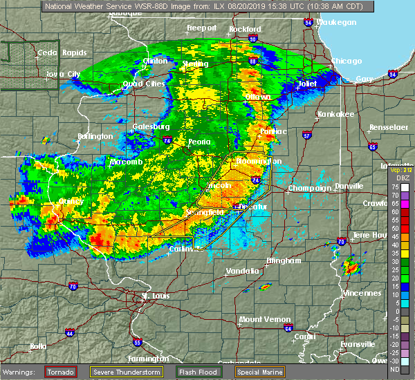 At 1042 am cdt, severe thunderstorms were located along a line extending from 7 miles east of colfax to near de land to near moweaqua, moving east at 50 mph (radar indicated). Hazards include 70 mph wind gusts and quarter size hail. Hail damage to vehicles is expected. expect considerable tree damage. Wind damage is also likely to mobile homes, roofs, and outbuildings. At 1042 am cdt, severe thunderstorms were located along a line extending from 7 miles east of colfax to near de land to near moweaqua, moving east at 50 mph (radar indicated). Hazards include 70 mph wind gusts and quarter size hail. Hail damage to vehicles is expected. expect considerable tree damage. Wind damage is also likely to mobile homes, roofs, and outbuildings.
|
| 8/12/2019 9:49 PM CDT |
 At 948 pm cdt, severe thunderstorms were located along a line extending from near arcola to 7 miles east of moweaqua, moving southeast at 25 mph (radar indicated). Hazards include 60 mph wind gusts and quarter size hail. Hail damage to vehicles is expected. Expect wind damage to roofs, siding, and trees. At 948 pm cdt, severe thunderstorms were located along a line extending from near arcola to 7 miles east of moweaqua, moving southeast at 25 mph (radar indicated). Hazards include 60 mph wind gusts and quarter size hail. Hail damage to vehicles is expected. Expect wind damage to roofs, siding, and trees.
|
| 8/12/2019 9:01 PM CDT |
 At 901 pm cdt, a severe thunderstorm was located over hammond, or 12 miles north of sullivan, moving southeast at 20 mph (radar indicated). Hazards include 60 mph wind gusts and quarter size hail. Hail damage to vehicles is expected. Expect wind damage to roofs, siding, and trees. At 901 pm cdt, a severe thunderstorm was located over hammond, or 12 miles north of sullivan, moving southeast at 20 mph (radar indicated). Hazards include 60 mph wind gusts and quarter size hail. Hail damage to vehicles is expected. Expect wind damage to roofs, siding, and trees.
|
| 6/19/2019 7:57 PM CDT |
 At 750 pm cdt, a severe thunderstorm capable of producing a tornado was located near arthur, or 7 miles northeast of sullivan, moving east at 25 mph (radar indicated rotation). Hazards include tornado. Flying debris will be dangerous to those caught without shelter. mobile homes will be damaged or destroyed. damage to roofs, windows, and vehicles will occur. tree damage is likely. this dangerous storm will be near, arthur around 755 pm cdt. Other locations impacted by this tornadic thunderstorm include cadwell. At 750 pm cdt, a severe thunderstorm capable of producing a tornado was located near arthur, or 7 miles northeast of sullivan, moving east at 25 mph (radar indicated rotation). Hazards include tornado. Flying debris will be dangerous to those caught without shelter. mobile homes will be damaged or destroyed. damage to roofs, windows, and vehicles will occur. tree damage is likely. this dangerous storm will be near, arthur around 755 pm cdt. Other locations impacted by this tornadic thunderstorm include cadwell.
|
| 6/19/2019 7:50 PM CDT |
 At 750 pm cdt, a severe thunderstorm capable of producing a tornado was located near arthur, or 7 miles northeast of sullivan, moving east at 25 mph (radar indicated rotation). Hazards include tornado. Flying debris will be dangerous to those caught without shelter. mobile homes will be damaged or destroyed. damage to roofs, windows, and vehicles will occur. tree damage is likely. this dangerous storm will be near, arthur around 755 pm cdt. Other locations impacted by this tornadic thunderstorm include cadwell. At 750 pm cdt, a severe thunderstorm capable of producing a tornado was located near arthur, or 7 miles northeast of sullivan, moving east at 25 mph (radar indicated rotation). Hazards include tornado. Flying debris will be dangerous to those caught without shelter. mobile homes will be damaged or destroyed. damage to roofs, windows, and vehicles will occur. tree damage is likely. this dangerous storm will be near, arthur around 755 pm cdt. Other locations impacted by this tornadic thunderstorm include cadwell.
|
| 6/19/2019 7:27 PM CDT |
 At 726 pm cdt, a severe thunderstorm capable of producing a tornado was located over bethany, or near sullivan, moving east at 20 mph (radar indicated rotation. a funnel cloud was also reported east of bethany by a spotter). Hazards include tornado. Flying debris will be dangerous to those caught without shelter. mobile homes will be damaged or destroyed. damage to roofs, windows, and vehicles will occur. tree damage is likely. this dangerous storm will be near, sullivan around 740 pm cdt. arthur around 800 pm cdt. Other locations impacted by this tornadic thunderstorm include cadwell. At 726 pm cdt, a severe thunderstorm capable of producing a tornado was located over bethany, or near sullivan, moving east at 20 mph (radar indicated rotation. a funnel cloud was also reported east of bethany by a spotter). Hazards include tornado. Flying debris will be dangerous to those caught without shelter. mobile homes will be damaged or destroyed. damage to roofs, windows, and vehicles will occur. tree damage is likely. this dangerous storm will be near, sullivan around 740 pm cdt. arthur around 800 pm cdt. Other locations impacted by this tornadic thunderstorm include cadwell.
|
| 5/23/2019 2:14 AM CDT |
 At 213 am cdt, a severe thunderstorm was located over cooks mill, or near mattoon, moving east at 55 mph (radar indicated). Hazards include 60 mph wind gusts and penny size hail. brief tornados are possible with this storm. expect damage to roofs, siding, and trees At 213 am cdt, a severe thunderstorm was located over cooks mill, or near mattoon, moving east at 55 mph (radar indicated). Hazards include 60 mph wind gusts and penny size hail. brief tornados are possible with this storm. expect damage to roofs, siding, and trees
|
| 5/23/2019 2:01 AM CDT |
 A severe thunderstorm warning remains in effect until 215 am cdt for moultrie. central shelby. western douglas and southeastern macon counties. at 200 am cdt, a severe thunderstorm was located near arcola, or 8 miles southwest of tuscola, moving east at 35 mph. hazard. 60 mph wind gusts. Brief tornados are possible with this. A severe thunderstorm warning remains in effect until 215 am cdt for moultrie. central shelby. western douglas and southeastern macon counties. at 200 am cdt, a severe thunderstorm was located near arcola, or 8 miles southwest of tuscola, moving east at 35 mph. hazard. 60 mph wind gusts. Brief tornados are possible with this.
|
| 5/23/2019 1:48 AM CDT |
 At 146 am cdt, a severe thunderstorm was located over arthur to pana, moving east at 35 mph (radar indicated). Hazards include 60 mph wind gusts. brief tornados are possible with this storm. Expect damage to roofs, siding, and trees. locations impacted include, decatur, taylorville, shelbyville, tuscola, sullivan, pana, mount zion, arcola, villa grove, arthur, moweaqua, cerro gordo, bethany, long creek, atwood, assumption, macon, lovington, morrisonville and stonington. This includes interstate 57 between mile markers 204 and 217. At 146 am cdt, a severe thunderstorm was located over arthur to pana, moving east at 35 mph (radar indicated). Hazards include 60 mph wind gusts. brief tornados are possible with this storm. Expect damage to roofs, siding, and trees. locations impacted include, decatur, taylorville, shelbyville, tuscola, sullivan, pana, mount zion, arcola, villa grove, arthur, moweaqua, cerro gordo, bethany, long creek, atwood, assumption, macon, lovington, morrisonville and stonington. This includes interstate 57 between mile markers 204 and 217.
|
| 5/23/2019 1:25 AM CDT |
 At 125 am cdt, a severe thunderstorm was located near dalton city, or 12 miles northwest of sullivan, moving east at 35 mph (radar indicated). Hazards include 60 mph wind gusts. expect damage to roofs, siding, and trees At 125 am cdt, a severe thunderstorm was located near dalton city, or 12 miles northwest of sullivan, moving east at 35 mph (radar indicated). Hazards include 60 mph wind gusts. expect damage to roofs, siding, and trees
|
| 5/19/2019 1:54 PM CDT |
 At 153 pm cdt, a severe thunderstorm was located about 5 miles northwest of arthur, or 11 miles northeast of sullivan, moving northeast at 45 mph (radar indicated). Hazards include 60 mph wind gusts and penny size hail. Expect damage to roofs, siding, and trees. Locations impacted include, arthur, atwood, lovington and cadwell. At 153 pm cdt, a severe thunderstorm was located about 5 miles northwest of arthur, or 11 miles northeast of sullivan, moving northeast at 45 mph (radar indicated). Hazards include 60 mph wind gusts and penny size hail. Expect damage to roofs, siding, and trees. Locations impacted include, arthur, atwood, lovington and cadwell.
|
| 5/19/2019 1:46 PM CDT |
 At 146 pm cdt, a severe thunderstorm was located over lovington, or 7 miles north of sullivan, moving northeast at 40 mph (radar indicated). Hazards include 60 mph wind gusts and nickel size hail. expect damage to roofs, siding, and trees At 146 pm cdt, a severe thunderstorm was located over lovington, or 7 miles north of sullivan, moving northeast at 40 mph (radar indicated). Hazards include 60 mph wind gusts and nickel size hail. expect damage to roofs, siding, and trees
|
| 6/10/2018 2:12 PM CDT |
 At 212 pm cdt, a severe thunderstorm was located over argenta, or 11 miles west of monticello, moving southeast at 45 mph (radar indicated). Hazards include 60 mph wind gusts. expect damage to roofs, siding, and trees At 212 pm cdt, a severe thunderstorm was located over argenta, or 11 miles west of monticello, moving southeast at 45 mph (radar indicated). Hazards include 60 mph wind gusts. expect damage to roofs, siding, and trees
|
| 7/16/2017 7:32 PM CDT |
 At 731 pm cdt, a severe thunderstorm was located near lovington, or near sullivan, moving south at 15 mph (trained weather spotters). Hazards include golf ball size hail and 60 mph wind gusts. People and animals outdoors will be injured. expect hail damage to roofs, siding, windows, and vehicles. Expect wind damage to roofs, siding, and trees. At 731 pm cdt, a severe thunderstorm was located near lovington, or near sullivan, moving south at 15 mph (trained weather spotters). Hazards include golf ball size hail and 60 mph wind gusts. People and animals outdoors will be injured. expect hail damage to roofs, siding, windows, and vehicles. Expect wind damage to roofs, siding, and trees.
|
| 7/11/2017 10:01 AM CDT |
 At 1001 am cdt, a severe thunderstorm was located near atwood, or 8 miles west of tuscola, moving east at 50 mph (radar indicated). Hazards include 60 mph wind gusts. Expect damage to roofs, siding, and trees. locations impacted include, charleston, monticello, tuscola, savoy, tolono, arcola, villa grove, arthur, bement, philo, atwood, lovington, pesotum, hammond, camargo, humboldt, hindsboro, cooks mill, white heath and bourbon. this includes the following highways, interstate 57 between mile markers 194 and 229. Interstate 72 between mile markers 163 and 170. At 1001 am cdt, a severe thunderstorm was located near atwood, or 8 miles west of tuscola, moving east at 50 mph (radar indicated). Hazards include 60 mph wind gusts. Expect damage to roofs, siding, and trees. locations impacted include, charleston, monticello, tuscola, savoy, tolono, arcola, villa grove, arthur, bement, philo, atwood, lovington, pesotum, hammond, camargo, humboldt, hindsboro, cooks mill, white heath and bourbon. this includes the following highways, interstate 57 between mile markers 194 and 229. Interstate 72 between mile markers 163 and 170.
|
| 7/11/2017 9:33 AM CDT |
 At 933 am cdt, a severe thunderstorm was located near cerro gordo, or 9 miles northeast of decatur, moving east at 55 mph (radar indicated). Hazards include 60 mph wind gusts. expect damage to roofs, siding, and trees At 933 am cdt, a severe thunderstorm was located near cerro gordo, or 9 miles northeast of decatur, moving east at 55 mph (radar indicated). Hazards include 60 mph wind gusts. expect damage to roofs, siding, and trees
|
| 7/10/2017 9:25 PM CDT |
 The severe thunderstorm warning for moultrie, southern piatt and macon counties will expire at 930 pm cdt, the storms which prompted the warning have weakened below severe limits, and no longer pose an immediate threat to life or property. therefore the warning will be allowed to expire. however gusty winds and heavy rain are still possible with these thunderstorms. a severe thunderstorm watch remains in effect until 1100 pm cdt for central illinois. The severe thunderstorm warning for moultrie, southern piatt and macon counties will expire at 930 pm cdt, the storms which prompted the warning have weakened below severe limits, and no longer pose an immediate threat to life or property. therefore the warning will be allowed to expire. however gusty winds and heavy rain are still possible with these thunderstorms. a severe thunderstorm watch remains in effect until 1100 pm cdt for central illinois.
|
| 7/10/2017 9:05 PM CDT |
 At 905 pm cdt, severe thunderstorms were located along a line extending from near monticello to near mount zion to near macon, moving southeast at 35 mph (radar indicated). Hazards include 60 mph wind gusts. Expect damage to roofs, siding, and trees. locations impacted include, decatur, monticello, sullivan, mount zion, forsyth, maroa, bement, cerro gordo, harristown, bethany, long creek, warrensburg, lovington, argenta, oreana, dalton city, hammond, oakley, cisco and lake city. This includes interstate 72 between mile markers 129 and 165. At 905 pm cdt, severe thunderstorms were located along a line extending from near monticello to near mount zion to near macon, moving southeast at 35 mph (radar indicated). Hazards include 60 mph wind gusts. Expect damage to roofs, siding, and trees. locations impacted include, decatur, monticello, sullivan, mount zion, forsyth, maroa, bement, cerro gordo, harristown, bethany, long creek, warrensburg, lovington, argenta, oreana, dalton city, hammond, oakley, cisco and lake city. This includes interstate 72 between mile markers 129 and 165.
|
| 7/10/2017 8:44 PM CDT |
 At 843 pm cdt, severe thunderstorms were located along a line extending from near weldon to near harristown to niantic, moving southeast at 55 mph (radar indicated). Hazards include 60 mph wind gusts. expect damage to roofs, siding, and trees At 843 pm cdt, severe thunderstorms were located along a line extending from near weldon to near harristown to niantic, moving southeast at 55 mph (radar indicated). Hazards include 60 mph wind gusts. expect damage to roofs, siding, and trees
|
| 4/29/2017 6:42 PM CDT |
 At 641 pm cdt, severe thunderstorms were located along a line extending from near mansfield to near tuscola to near bible grove, moving northeast at 45 mph (radar indicated). Hazards include 60 mph wind gusts and quarter size hail. Hail damage to vehicles is expected. expect wind damage to roofs, siding, and trees. locations impacted include, champaign, charleston, mattoon, rantoul, effingham, monticello, tuscola, sullivan, newton, toledo, urbana, savoy, mahomet, st. joseph, tolono, arcola, villa grove, altamont, arthur and fisher. this includes the following highways, interstate 57 between mile markers 142 and 249. interstate 70 between mile markers 78 and 123. interstate 72 between mile markers 157 and 182. Interstate 74 between mile markers 161 and 192. At 641 pm cdt, severe thunderstorms were located along a line extending from near mansfield to near tuscola to near bible grove, moving northeast at 45 mph (radar indicated). Hazards include 60 mph wind gusts and quarter size hail. Hail damage to vehicles is expected. expect wind damage to roofs, siding, and trees. locations impacted include, champaign, charleston, mattoon, rantoul, effingham, monticello, tuscola, sullivan, newton, toledo, urbana, savoy, mahomet, st. joseph, tolono, arcola, villa grove, altamont, arthur and fisher. this includes the following highways, interstate 57 between mile markers 142 and 249. interstate 70 between mile markers 78 and 123. interstate 72 between mile markers 157 and 182. Interstate 74 between mile markers 161 and 192.
|
| 4/29/2017 6:14 PM CDT |
 At 613 pm cdt, severe thunderstorms were located along a line extending from near maroa to near sullivan to near kinmundy, moving northeast at 40 mph (radar indicated). Hazards include 60 mph wind gusts and quarter size hail. Hail damage to vehicles is expected. Expect wind damage to roofs, siding, and trees. At 613 pm cdt, severe thunderstorms were located along a line extending from near maroa to near sullivan to near kinmundy, moving northeast at 40 mph (radar indicated). Hazards include 60 mph wind gusts and quarter size hail. Hail damage to vehicles is expected. Expect wind damage to roofs, siding, and trees.
|
| 4/29/2017 6:06 PM CDT |
 At 606 pm cdt, a severe thunderstorm capable of producing a tornado was located near sullivan, moving northeast at 50 mph (weather spotters reported a funnel cloud). Hazards include tornado and quarter size hail. Flying debris will be dangerous to those caught without shelter. mobile homes will be damaged or destroyed. damage to roofs, windows, and vehicles will occur. tree damage is likely. this dangerous storm will be near, arthur around 615 pm cdt. Other locations impacted by this tornadic thunderstorm include cadwell and kirksville. At 606 pm cdt, a severe thunderstorm capable of producing a tornado was located near sullivan, moving northeast at 50 mph (weather spotters reported a funnel cloud). Hazards include tornado and quarter size hail. Flying debris will be dangerous to those caught without shelter. mobile homes will be damaged or destroyed. damage to roofs, windows, and vehicles will occur. tree damage is likely. this dangerous storm will be near, arthur around 615 pm cdt. Other locations impacted by this tornadic thunderstorm include cadwell and kirksville.
|
| 4/29/2017 5:50 PM CDT |
 At 549 pm cdt, a severe thunderstorm capable of producing a tornado was located near westervelt, or 11 miles north of shelbyville, moving northeast at 50 mph (weather spotters reported funnel cloud). Hazards include tornado and quarter size hail. Flying debris will be dangerous to those caught without shelter. mobile homes will be damaged or destroyed. damage to roofs, windows, and vehicles will occur. tree damage is likely. this dangerous storm will be near, findlay around 555 pm cdt. bethany around 600 pm cdt. sullivan around 605 pm cdt. lovington and allenville around 610 pm cdt. arthur around 615 pm cdt. Other locations impacted by this tornadic thunderstorm include cadwell and kirksville. At 549 pm cdt, a severe thunderstorm capable of producing a tornado was located near westervelt, or 11 miles north of shelbyville, moving northeast at 50 mph (weather spotters reported funnel cloud). Hazards include tornado and quarter size hail. Flying debris will be dangerous to those caught without shelter. mobile homes will be damaged or destroyed. damage to roofs, windows, and vehicles will occur. tree damage is likely. this dangerous storm will be near, findlay around 555 pm cdt. bethany around 600 pm cdt. sullivan around 605 pm cdt. lovington and allenville around 610 pm cdt. arthur around 615 pm cdt. Other locations impacted by this tornadic thunderstorm include cadwell and kirksville.
|
| 4/29/2017 5:26 PM CDT |
 At 526 pm cdt, severe thunderstorms were located along a line extending from mount auburn to 8 miles north of ramsey, moving northeast at 50 mph (trained weather spotters). Hazards include 60 mph wind gusts and quarter size hail. Hail damage to vehicles is expected. Expect wind damage to roofs, siding, and trees. At 526 pm cdt, severe thunderstorms were located along a line extending from mount auburn to 8 miles north of ramsey, moving northeast at 50 mph (trained weather spotters). Hazards include 60 mph wind gusts and quarter size hail. Hail damage to vehicles is expected. Expect wind damage to roofs, siding, and trees.
|
| 3/30/2017 3:22 PM CDT |
 At 321 pm cdt, severe thunderstorms were located along a line extending from near cerro gordo to near humboldt, moving north at 50 mph (radar indicated). Hazards include 60 mph wind gusts and penny size hail. expect damage to roofs, siding, and trees At 321 pm cdt, severe thunderstorms were located along a line extending from near cerro gordo to near humboldt, moving north at 50 mph (radar indicated). Hazards include 60 mph wind gusts and penny size hail. expect damage to roofs, siding, and trees
|
| 3/7/2017 1:57 AM CST |
 At 156 am cst, severe thunderstorms were located along a line extending from near pesotum to near stewardson, moving east at 65 mph (radar indicated). Hazards include 60 mph wind gusts. expect damage to roofs, siding, and trees At 156 am cst, severe thunderstorms were located along a line extending from near pesotum to near stewardson, moving east at 65 mph (radar indicated). Hazards include 60 mph wind gusts. expect damage to roofs, siding, and trees
|
| 3/7/2017 1:44 AM CST |
 At 143 am cst, severe thunderstorms were located along a line extending from 6 miles south of white heath to near cowden, moving east at 60 mph (radar indicated). Hazards include 60 mph wind gusts and quarter size hail. Hail damage to vehicles is expected. expect wind damage to roofs, siding, and trees. locations impacted include, monticello, shelbyville, sullivan, arthur, bement, bethany, lovington, windsor, stewardson, findlay, cowden, tower hill, hammond, allenville, westervelt, white heath, strasburg, herrick, clarksburg and gays. This includes interstate 72 between mile markers 164 and 173. At 143 am cst, severe thunderstorms were located along a line extending from 6 miles south of white heath to near cowden, moving east at 60 mph (radar indicated). Hazards include 60 mph wind gusts and quarter size hail. Hail damage to vehicles is expected. expect wind damage to roofs, siding, and trees. locations impacted include, monticello, shelbyville, sullivan, arthur, bement, bethany, lovington, windsor, stewardson, findlay, cowden, tower hill, hammond, allenville, westervelt, white heath, strasburg, herrick, clarksburg and gays. This includes interstate 72 between mile markers 164 and 173.
|
| 3/7/2017 1:16 AM CST |
 At 115 am cst, severe thunderstorms were located along a line extending from de land to 7 miles northeast of nokomis, moving east at 75 mph (radar indicated). Hazards include 60 mph wind gusts and quarter size hail. Hail damage to vehicles is expected. Expect wind damage to roofs, siding, and trees. At 115 am cst, severe thunderstorms were located along a line extending from de land to 7 miles northeast of nokomis, moving east at 75 mph (radar indicated). Hazards include 60 mph wind gusts and quarter size hail. Hail damage to vehicles is expected. Expect wind damage to roofs, siding, and trees.
|
| 11/2/2016 6:19 PM CDT |
 At 618 pm cdt, severe thunderstorms capable of producing brief tornado touchdowns and damaging winds were located along a line extending from 8 miles west of pesotum to atwood to near sullivan, moving southeast at 40 mph. circulations were observed near atwood at just northeast of sullivan (radar indicated rotation). Hazards include tornado. Flying debris will be dangerous to those caught without shelter. mobile homes will be damaged or destroyed. damage to roofs, windows, and vehicles will occur. tree damage is likely. these dangerous storms will be near, tuscola and arcola around 635 pm cdt. villa grove, camargo and cooks mill around 640 pm cdt. mattoon, humboldt and hindsboro around 645 pm cdt. other locations impacted by these tornadic storms include bourbon, chesterville, cadwell and garrett. This includes interstate 57 between mile markers 190 and 217. At 618 pm cdt, severe thunderstorms capable of producing brief tornado touchdowns and damaging winds were located along a line extending from 8 miles west of pesotum to atwood to near sullivan, moving southeast at 40 mph. circulations were observed near atwood at just northeast of sullivan (radar indicated rotation). Hazards include tornado. Flying debris will be dangerous to those caught without shelter. mobile homes will be damaged or destroyed. damage to roofs, windows, and vehicles will occur. tree damage is likely. these dangerous storms will be near, tuscola and arcola around 635 pm cdt. villa grove, camargo and cooks mill around 640 pm cdt. mattoon, humboldt and hindsboro around 645 pm cdt. other locations impacted by these tornadic storms include bourbon, chesterville, cadwell and garrett. This includes interstate 57 between mile markers 190 and 217.
|
| 7/13/2016 5:31 PM CDT |
 At 530 pm cdt, severe thunderstorms were located along a line extending from near monticello to near sullivan to near windsor, moving east at 40 mph (radar indicated). Hazards include 60 mph wind gusts. Expect damage to roofs. siding. and trees. Locations impacted include, sullivan, arthur, bement, cerro gordo, lovington, hammond, allenville, gays, kirksville, cadwell, la place, lake city and milmine. At 530 pm cdt, severe thunderstorms were located along a line extending from near monticello to near sullivan to near windsor, moving east at 40 mph (radar indicated). Hazards include 60 mph wind gusts. Expect damage to roofs. siding. and trees. Locations impacted include, sullivan, arthur, bement, cerro gordo, lovington, hammond, allenville, gays, kirksville, cadwell, la place, lake city and milmine.
|
| 7/13/2016 5:21 PM CDT |
 At 521 pm cdt, severe thunderstorms were located along a line extending from near bement to near sullivan to near montrose, moving east at 45 mph (radar indicated). Hazards include 60 mph wind gusts. Expect damage to roofs. siding. And trees. At 521 pm cdt, severe thunderstorms were located along a line extending from near bement to near sullivan to near montrose, moving east at 45 mph (radar indicated). Hazards include 60 mph wind gusts. Expect damage to roofs. siding. And trees.
|
| 7/13/2016 4:58 PM CDT |
 At 457 pm cdt, severe thunderstorms were located along a line extending from near forsyth to near moweaqua to 7 miles northeast of ramsey, moving east at 40 mph (radar indicated). Hazards include 60 mph wind gusts. Expect damage to roofs. siding. And trees. At 457 pm cdt, severe thunderstorms were located along a line extending from near forsyth to near moweaqua to 7 miles northeast of ramsey, moving east at 40 mph (radar indicated). Hazards include 60 mph wind gusts. Expect damage to roofs. siding. And trees.
|
| 6/15/2016 2:42 PM CDT |
 At 242 pm cdt, a severe thunderstorm was located over humboldt, or 9 miles north of mattoon, moving east at 20 mph (radar indicated). Hazards include 60 mph wind gusts and half dollar size hail. Hail damage to vehicles is expected. expect wind damage to roofs, siding, and trees. locations impacted include, charleston, mattoon, sullivan, arcola, arthur, oakland, humboldt, hindsboro, rardin, cooks mill, bourbon, fairgrange, coles county airport, chesterville, cadwell and bushton. This includes interstate 57 between mile markers 190 and 208. At 242 pm cdt, a severe thunderstorm was located over humboldt, or 9 miles north of mattoon, moving east at 20 mph (radar indicated). Hazards include 60 mph wind gusts and half dollar size hail. Hail damage to vehicles is expected. expect wind damage to roofs, siding, and trees. locations impacted include, charleston, mattoon, sullivan, arcola, arthur, oakland, humboldt, hindsboro, rardin, cooks mill, bourbon, fairgrange, coles county airport, chesterville, cadwell and bushton. This includes interstate 57 between mile markers 190 and 208.
|
| 6/15/2016 2:30 PM CDT | Quarter sized hail reported 1.9 miles NNE of Arthur, IL, along county road 1900n |
| 6/15/2016 2:25 PM CDT |
 At 225 pm cdt, a severe thunderstorm was located near arthur, or 9 miles northeast of sullivan, moving southeast at 20 mph (radar indicated). Hazards include 60 mph wind gusts and quarter size hail. Hail damage to vehicles is expected. Expect wind damage to roofs, siding, and trees. At 225 pm cdt, a severe thunderstorm was located near arthur, or 9 miles northeast of sullivan, moving southeast at 20 mph (radar indicated). Hazards include 60 mph wind gusts and quarter size hail. Hail damage to vehicles is expected. Expect wind damage to roofs, siding, and trees.
|
| 12/23/2015 10:13 AM CST | The severe thunderstorm warning for piatt, western coles, moultrie, southeastern macon, northern cumberland, eastern shelby and western douglas counties will expire at 1015 am cst, the storms which prompted the warning have weakened below severe limits, and no longer pose an immediate threat to life or property. therefore the warning will be allowed to expire. however gusty winds are still possible with these thunderstorms. a tornado watch remains in effect until 500 pm cst for east central illinois. |
| 12/23/2015 9:59 AM CST | A severe thunderstorm warning remains in effect until 1015 am cst for piatt. western coles. moultrie. southeastern macon. northern cumberland. eastern shelby and western douglas counties. at 959 am cst. severe thunderstorms were located along a line extending from near cerro gordo to 5 miles northwest of stewardson. Moving northeast at 55 mph. |
| 12/23/2015 9:48 AM CST | At 947 am cst, severe thunderstorms were located along a line extending from near mount zion to near cowden, moving northeast at 55 mph (radar indicated). Hazards include 60 mph wind gusts. Expect damage to roofs. Siding and trees. |
| 7/14/2015 1:00 AM CDT | Tree and powerlines down in douglas county IL, 0.2 miles SSE of Arthur, IL |
| 7/14/2015 12:56 AM CDT |
 At 1255 am cdt, a severe thunderstorm was located over lovington, or 8 miles north of sullivan, moving east at 35 mph (radar indicated). Hazards include 60 mph wind gusts and quarter size hail. Hail damage to vehicles is expected. expect wind damage to roofs, siding and trees. Locations impacted include, sullivan, arthur, bethany, lovington, cadwell and lake city. At 1255 am cdt, a severe thunderstorm was located over lovington, or 8 miles north of sullivan, moving east at 35 mph (radar indicated). Hazards include 60 mph wind gusts and quarter size hail. Hail damage to vehicles is expected. expect wind damage to roofs, siding and trees. Locations impacted include, sullivan, arthur, bethany, lovington, cadwell and lake city.
|
| 7/14/2015 12:42 AM CDT |
 At 1242 am cdt, a severe thunderstorm was located over dalton city, or 11 miles southeast of decatur, moving east at 35 mph (radar indicated). Hazards include 60 mph wind gusts and quarter size hail. Hail damage to vehicles is expected. Expect wind damage to roofs, siding and trees. At 1242 am cdt, a severe thunderstorm was located over dalton city, or 11 miles southeast of decatur, moving east at 35 mph (radar indicated). Hazards include 60 mph wind gusts and quarter size hail. Hail damage to vehicles is expected. Expect wind damage to roofs, siding and trees.
|
| 6/20/2015 10:46 PM CDT |
 At 1046 pm cdt, severe thunderstorms were located along a line extending from argenta to near moweaqua to 10 miles west of pana, moving east at 45 mph (trained weather spotters). Hazards include 60 mph wind gusts. Expect damage to roofs. Siding and trees. At 1046 pm cdt, severe thunderstorms were located along a line extending from argenta to near moweaqua to 10 miles west of pana, moving east at 45 mph (trained weather spotters). Hazards include 60 mph wind gusts. Expect damage to roofs. Siding and trees.
|
| 6/7/2015 9:52 PM CDT | At 951 pm cdt, severe thunderstorms were located along a line extending from near potomac to near allerton to near newman to humboldt, moving east at 45 mph (radar indicated). Hazards include 60 mph wind gusts and quarter size hail. Hail damage to vehicles is expected. expect wind damage to roofs, siding and trees. locations impacted include, danville, charleston, mattoon, paris, tuscola, st. joseph, georgetown, westville, arcola, tilton, villa grove, arthur, catlin, oakwood, philo, chrisman, rossville, sidney, atwood and homer. this includes the following highways, interstate 57 between mile markers 189 and 219. Interstate 74 between mile markers 192 and 220. |
| 6/7/2015 9:29 PM CDT | At 929 pm cdt, severe thunderstorms were located along a line extending from 6 miles north of rantoul to philo to near tuscola to 4 miles north of sullivan, moving east at 45 mph (radar indicated). Hazards include 60 mph wind gusts and quarter size hail. Hail damage to vehicles is expected. Expect wind damage to roofs, siding and trees. |
| 6/7/2015 9:10 PM CDT | At 909 pm cdt, severe thunderstorms were located along a line extending from lake of the woods to near atwood to near dalton city, moving east at 50 mph (radar indicated). Hazards include 60 mph wind gusts and quarter size hail. Hail damage to vehicles is expected. expect wind damage to roofs, siding and trees. locations impacted include, champaign, decatur, urbana, rantoul, monticello, tuscola, savoy, mahomet, mount zion, st. joseph, tolono, arcola, villa grove, arthur, fisher, bement, philo, cerro gordo, long creek and sidney. this includes the following highways, interstate 57 between mile markers 202 and 256. interstate 72 between mile markers 157 and 182. Interstate 74 between mile markers 161 and 198. |
| 6/7/2015 8:54 PM CDT | At 854 pm cdt, severe thunderstorms were located along a line extending from 5 miles north of mansfield to near cerro gordo to near decatur, moving east at 50 mph (radar indicated). Hazards include 60 mph wind gusts. Expect damage to roofs. Siding and trees. |
| 6/25/2013 6:55 PM CDT | Power lines blown down in arthur on both sides of the county line...power lines also blown down in newman at 7p in douglas county IL, 0.2 miles SSE of Arthur, IL |
| 5/2/2013 1:05 PM CDT | Power poles blown down along illinois route 133 near arthu in douglas county IL, 0.2 miles SSE of Arthur, IL |
| 5/2/2013 1:05 PM CDT | Four power poles blown down along illinois route 133 near arthur in moultrie county. people trapped in cars by downed power lines. no injurie in moultrie county IL, 0.8 miles NE of Arthur, IL |
| 5/2/2013 1:05 PM CDT | Four power poles blown down along illinois route 133 near arthur in moultrie county. people trapped in cars by downed power lines. no injuries. ...corrected the locatio in moultrie county IL, 3.3 miles E of Arthur, IL |
Hail Maps for Arthur, IL


Connect with Interactive Hail Maps