

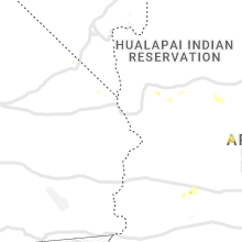
Hail Map for Saturday, July 16, 2022

Number of Impacted Households on 7/16/2022
0
Impacted by 1" or Larger Hail
0
Impacted by 1.75" or Larger Hail
0
Impacted by 2.5" or Larger Hail
Square Miles of Populated Area Impacted on 7/16/2022
0
Impacted by 1" or Larger Hail
0
Impacted by 1.75" or Larger Hail
0
Impacted by 2.5" or Larger Hail


Cities Most Affected by Hail Storms of 7/16/2022
| Hail Size | Demographics of Zip Codes Affected | ||||||
|---|---|---|---|---|---|---|---|
| City | Count | Average | Largest | Pop Density | House Value | Income | Age |
| Ashton, NE | 1 | 2.75 | 2.75 | 2 | $31k | $31.1k | 47.6 |
| Burwell, NE | 1 | 1.75 | 1.75 | 1 | $39k | $26.8k | 50.4 |
| Farwell, NE | 1 | 1.75 | 1.75 | 4 | $40k | $29.7k | 42.5 |
Hail and Wind Damage Spotted on 7/16/2022
Filter by Report Type:Hail ReportsWind Reports
States Impacted
Virginia, North Carolina, Maryland, Nebraska, New Jersey, Minnesota, Arizona, Montana, Colorado, Nevada, Missouri, Kansas, IndianaVirginia
| Local Time | Report Details |
|---|---|
| 1:14 PM EDT | One tree down along cedar tree road due to thunderstorm wind in appomattox county VA, 63.4 miles E of Roanoke, VA |
| 1:20 PM EDT | One tree down along the 800 block of railroad lane due to thunderstorm wind in appomattox county VA, 62.1 miles WSW of Richmond, VA |
| 1:33 PM EDT | Multiple trees and power lines down along tabor road due to thunderstorm wind in campbell county VA, 43.8 miles ESE of Roanoke, VA |
| 1:35 PM EDT | Multiple trees and power lines down along wyatt miles road due to thunderstorm wind in campbell county VA, 45 miles ESE of Roanoke, VA |
| 1:53 PM EDT | Multiple trees down along kings cross road due to thunderstorm win in charlotte county VA, 70.4 miles SW of Richmond, VA |
| 1:56 PM EDT | Corrects previous tstm wnd dmg report from 2 wsw wylliesburg. multiple trees down along kings cross road due to thunderstorm win in charlotte county VA, 70.4 miles SW of Richmond, VA |
| 2:45 PM EDT | Tree down on hobbs mill road. time estimate in nottoway county VA, 26.3 miles SSW of Richmond, VA |
| 2:52 PM EDT | Tree down on fairground road. time estimate in goochland county VA, 15.9 miles NNW of Richmond, VA |
| 3:09 PM EDT | One tree down along berry hill road due to thunderstorm wind in pittsylvania county VA, 53 miles SSE of Roanoke, VA |
| 3:14 PM EDT | Quarter sized hail reported near Montpelier, VA, 21.2 miles N of Richmond, VA, report relayed by 911 center. |
| 3:14 PM EDT | Multiple trees and power lines down in and around montpelier. time estimate in hanover county VA, 21.2 miles N of Richmond, VA |
| 3:21 PM EDT | One tree down in the randolph area due to thunderstorm wind in charlotte county VA, 69.7 miles WSW of Richmond, VA |
| 3:21 PM EDT | Quarter sized hail reported near Danville, VA, 54.5 miles SSE of Roanoke, VA, quarter size hail observed north of danville. report via mping. |
| 3:23 PM EDT | Quarter sized hail reported near Danville, VA, 55.4 miles SSE of Roanoke, VA, quarter size hail observed in danville city. report via mping. |
| 3:23 PM EDT | One tree down in the saxe area due to thunderstorm wind in charlotte county VA, 68.7 miles SW of Richmond, VA |
| 3:30 PM EDT | Trees and power lines down causing hundreds of power outages southeast of beaverdam. time estimate in hanover county VA, 27.5 miles N of Richmond, VA |
| 3:31 PM EDT | One tree down along west parker road due to thunderstorm wind in pittsylvania county VA, 53.7 miles SSE of Roanoke, VA |
| 3:34 PM EDT | One tree down due to thunderstorm winds along walnut creek roa in pittsylvania county VA, 52.8 miles SSE of Roanoke, VA |
| 3:34 PM EDT | One tree down along owen walker road due to thunderstorm wind in halifax county VA, 57 miles NNW of Raleigh, NC |
| 3:34 PM EDT | One tree down along the 1000 block of storys creek road due to thunderstorm wind in halifax county VA, 62.7 miles NNW of Raleigh, NC |
| 3:37 PM EDT | One tree down along the 1000 block of piney grove road due to thunderstorm wind in halifax county VA, 62.3 miles NNW of Raleigh, NC |
| 3:52 PM EDT | Hundreds of power outages just east of ruther glen likely caused by stor in caroline county VA, 32.2 miles NNE of Richmond, VA |
| 4:06 PM EDT | One power line down along ponderosa road due to thunderstorm wind in halifax county VA, 61.6 miles NNW of Raleigh, NC |
| 4:13 PM EDT | One power line down at the intersection of north main street and moore street due to thunderstorm wind in halifax county VA, 65.3 miles NNW of Raleigh, NC |
| 4:18 PM EDT | One power line down along seven oak drive due to thunderstorm wind in halifax county VA, 63.8 miles NNW of Raleigh, NC |
| 4:20 PM EDT | Cluster of around 150 power outages near port royal likely caused by storm. time estimate in caroline county VA, 52.4 miles NNE of Richmond, VA |
| 4:24 PM EDT | Tree down on i-85 at mm25... which is just southeast of alberta. time estimate in brunswick county VA, 46.5 miles SSW of Richmond, VA |
| 4:26 PM EDT | Trees and lines blew down near the 11000 block of millbank r in king george county VA, 57.9 miles NNE of Richmond, VA |
| 4:30 PM EDT | Trees down causing power outages just north of purdy. time estimate in greensville county VA, 44.5 miles S of Richmond, VA |
| 4:30 PM EDT | Trees down in buffalo junction. time estimated from rada in mecklenburg county VA, 56.2 miles N of Raleigh, NC |
| 4:45 PM EDT | Trees down. time estimated from radar dat in mecklenburg county VA, 62.6 miles NNE of Raleigh, NC |
| 5:06 PM EDT | Several trees down on the 1700 block of union mills road west of troy. time estimate in fluvanna county VA, 47.8 miles NW of Richmond, VA |
| 5:08 PM EDT | Several trees down on n boston road. time estimate in fluvanna county VA, 45.8 miles NW of Richmond, VA |
| 5:45 PM EDT | Numerous trees blew down along va-614 locust dale roa in madison county VA, 69 miles NNW of Richmond, VA |
| 5:50 PM EDT | Several trees blew down along va-614 locust dale road in rapida in culpeper county VA, 60.1 miles NNW of Richmond, VA |
| 5:54 PM EDT | Several trees blew down near and along clarks mountain r in orange county VA, 58.7 miles NNW of Richmond, VA |
| 6:03 PM EDT | Numerous trees blew down near the intersection of va-628 clifton road and barclay lane/jackson's quarters roa in orange county VA, 57.4 miles NNW of Richmond, VA |
| 6:05 PM EDT | Trees blew down near va-729 eggbornsville roa in culpeper county VA, 71.3 miles NNW of Richmond, VA |
| 6:57 PM EDT | A tree blew down on stagebridge r in nelson county VA, 66.6 miles WNW of Richmond, VA |
| 8:27 PM EDT | Nearly 150 power outages in and around eastville likely caused by storm. time estimate in northampton county VA, 41.6 miles N of Virginia Beach, VA |
North Carolina
| Local Time | Report Details |
|---|---|
| 1:39 PM EDT | Numerous trees down with some on power lines in the granite quarry and salisbury are in rowan county NC, 35.6 miles NE of Charlotte, NC |
| 2:15 PM EDT | Large tree fell on a ca in mecklenburg county NC, 0.5 miles NNW of Charlotte, NC |
| 3:49 PM EDT | A tree was reported down near the intersection of mill creek rd and lee s in orange county NC, 40.6 miles NW of Raleigh, NC |
| 4:46 PM EDT | A tree was reported down near the intersection of joe pruitt rd and corwall rd. time estimated by rada in granville county NC, 37.5 miles N of Raleigh, NC |
| 4:52 PM EDT | A tree was reported down near the intersection of sunset rd and hebron rd. time estimated by rada in granville county NC, 39.7 miles N of Raleigh, NC |
| 4:55 PM EDT | A tree was reported down near the intersection of roxboro rd and college st. time estimated by rada in granville county NC, 37 miles N of Raleigh, NC |
| 4:55 PM EDT | A tree was reported down near the intersection of ivey day rd and goshen st in oxford. time estimated by rada in granville county NC, 36.9 miles N of Raleigh, NC |
| 5:08 PM EDT | Reports of numerous trees down in granville count in granville county NC, 44.6 miles N of Raleigh, NC |
| 5:10 PM EDT | Power lines were reported down near the intersection of hicksboro rd and stagecoach r in vance county NC, 43.9 miles N of Raleigh, NC |
| 5:13 PM EDT | A large tree was reported down near the intersection of oxford rd and yowland rd in the town of henderso in vance county NC, 38.9 miles NNE of Raleigh, NC |
| 6:04 PM EDT | A tree was reported down along nc highway 43 northwest of hollister. time estimated by rada in warren county NC, 50.9 miles NE of Raleigh, NC |
| 6:05 PM EDT | A tree was reported down across the roadway along porter rd in hollister. time estimated by rada in halifax county NC, 52 miles NE of Raleigh, NC |
| 6:08 PM EDT | A tree was reported down near the intersection of white oak rd and fishing creek rd. time estimated by rada in halifax county NC, 52 miles ENE of Raleigh, NC |
| 6:10 PM EDT | A tree was reported down near the intersection of nc highway 48 and ringwood rd. time estimated by rada in halifax county NC, 53.2 miles ENE of Raleigh, NC |
| 6:23 PM EDT | A tree was reported down along i-95 northbound... between exit 168 and 171. time estimated by rada in halifax county NC, 69.9 miles NE of Raleigh, NC |
| 8:08 PM EDT | Tree down near intersection of greens cross road and old hwy 17. time estimate in bertie county NC, 68.7 miles SW of Virginia Beach, VA |
Maryland
| Local Time | Report Details |
|---|---|
| 2:51 PM EDT | Several trees and wires blew down in the pikesville are in baltimore county MD, 10.5 miles NNW of Baltimore, MD |
| 3:23 PM EDT | A tree blew down on patuxent hwy eastbound (md-32) near crain hw in anne arundel county MD, 15.3 miles S of Baltimore, MD |
| 3:54 PM EDT | Trees blew down onto wires bringing down a pole on river road in herald harbo in anne arundel county MD, 18 miles S of Baltimore, MD |
| 5:05 PM EDT | Several trees and wires blew down blocking roads between edgewater and harwoo in anne arundel county MD, 27.8 miles S of Baltimore, MD |
| 5:35 PM EDT | A tree blew down near dubois rd and morris farm r in charles county MD, 58.1 miles SSW of Baltimore, MD |
| 5:38 PM EDT | Several trees and wires blew down around dentsvill in charles county MD, 58.1 miles SSW of Baltimore, MD |
Nebraska
| Local Time | Report Details |
|---|---|
| 1:54 PM CDT | Quarter sized hail reported near Oneill, NE, 5 miles E of Oneill, NE |
| 2:00 PM CDT | 8-12 inch tree branches dow in holt county NE, 6.2 miles ESE of Oneill, NE |
| 2:42 PM CDT | Delayed report of lots of tree damag in antelope county NE, 23.7 miles SE of Oneill, NE |
| 5:50 PM CDT | Quarter sized hail reported near Burwell, NE, 42.4 miles SW of Oneill, NE |
| 6:15 PM CDT | Half Dollar sized hail reported near Burwell, NE, 44.3 miles SSW of Oneill, NE |
| 6:25 PM CDT | Audience member said trees are blocking streets in tow in garfield county NE, 52.9 miles SSW of Oneill, NE |
| 6:30 PM CDT | Golf Ball sized hail reported near Burwell, NE, 47.8 miles SSW of Oneill, NE |
| 6:35 PM CDT | Winds estimated 50 to 60 mph with hail in garfield county NE, 47.6 miles SSW of Oneill, NE |
| 6:51 PM CDT | Storm damage reported in valley county NE, 58.7 miles SSW of Oneill, NE |
| 6:54 PM CDT | Storm damage reported in valley county NE, 57.5 miles NNW of Grand Island, NE |
| 7:00 PM CDT | Storm damage reported in custer county NE, 53.7 miles ENE of North Platte, NE |
| 7:07 PM CDT | Emergency manager said deputies estimated 90 mph winds along highway 2. multiple trees are dow in custer county NE, 57.6 miles NE of North Platte, NE |
| 7:18 PM CDT | Storm damage reported in custer county NE, 62.1 miles ENE of North Platte, NE |
| 7:25 PM CDT | Broken bow airport in custer county NE, 61.4 miles ENE of North Platte, NE |
| 7:28 PM CDT | Quarter sized hail reported near Merna, NE, 57.3 miles ENE of North Platte, NE, report via facebook. multiple small tree limbs down and electricity out too. |
| 7:30 PM CDT | Multiple trees downed or uprooted. gas lines broken. corn crop strippe in custer county NE, 61.4 miles ENE of North Platte, NE |
| 7:35 PM CDT | Large tree limbs down. estimated 60 mph wind gust in furnas county NE, 69.9 miles SE of North Platte, NE |
| 7:36 PM CDT | Corrects previous tstm wnd dmg report from 2 ene holbrook. roof off two car garage destroyed. outbuilding destroyed at farmstead 4 w of arapahoe. half dollar hail also in furnas county NE, 70.3 miles SE of North Platte, NE |
| 7:51 PM CDT | Many tree limbs down in broken bow with several streets blocke in custer county NE, 61.4 miles ENE of North Platte, NE |
| 8:00 PM CDT | Report via twitte in custer county NE, 59.9 miles WNW of Grand Island, NE |
| 8:03 PM CDT | Pea size hail also in custer county NE, 59.9 miles WNW of Grand Island, NE |
| 8:04 PM CDT | 60 mph wind gust estimated at sherman reservoi in sherman county NE, 40.4 miles NW of Grand Island, NE |
| 8:06 PM CDT | Baseball sized hail reported near Ashton, NE, 31.8 miles NW of Grand Island, NE, 7 miles west of elba. report via facebook. |
| 8:11 PM CDT | Quarter sized hail reported near Ansley, NE, 59.9 miles WNW of Grand Island, NE |
| 8:23 PM CDT | Golf Ball sized hail reported near Farwell, NE, 24.8 miles NW of Grand Island, NE, nws employee reported hail on the ground in farwell. time is estimated from radar data. |
| 8:51 PM CDT | Storm damage reported in buffalo county NE, 44.7 miles WSW of Grand Island, NE |
| 8:54 PM CDT | Storm chaser reports 70-80 mph and possible brief tornado 3-4 se of cair in hall county NE, 11.3 miles WNW of Grand Island, NE |
| 9:24 PM CDT | Storm damage reported in adams county NE, 22.9 miles SSW of Grand Island, NE |
| 9:26 PM CDT | Power is out along with tree branches down in tow in clay county NE, 17.3 miles SSE of Grand Island, NE |
| 9:37 PM CDT | 60-70 mph estimate in adams county NE, 32.8 miles S of Grand Island, NE |
| 9:46 PM CDT | Storm damage reported in adams county NE, 21.9 miles S of Grand Island, NE |
| 9:49 PM CDT | Tree branches down and power is out in tow in clay county NE, 40.4 miles SSE of Grand Island, NE |
| 9:49 PM CDT | Trees down in fairfield and power is out als in clay county NE, 36.2 miles SSE of Grand Island, NE |
| 10:01 PM CDT | Tree branches down a long with power outage in clay county NE, 42.9 miles SSE of Grand Island, NE |
| 10:04 PM CDT | Storm damage reported in nuckolls county NE, 50.7 miles SSE of Grand Island, NE |
| 10:39 PM CDT | Storm damage reported in thayer county NE, 51.6 miles SSE of Grand Island, NE |
New Jersey
| Local Time | Report Details |
|---|---|
| 3:59 PM EDT | Trees on wires near mccampbell road in holmdel. time estimated via rada in monmouth county NJ, 25.3 miles SSW of Brooklyn, NY |
| 4:00 PM EDT | Quarter sized hail reported near Holmdel, NJ, 25.5 miles SSW of Brooklyn, NY, social media video of hail and strong winds. quarter size hail was estimated from the person who sent report in. time estimated via radar. |
| 4:01 PM EDT | Wires down in marlboro... nj. time estimated via rada in monmouth county NJ, 28.3 miles SSW of Brooklyn, NY |
| 4:20 PM EDT | Tree down through a deck left some damage via social media. time estimated via rada in monmouth county NJ, 29.5 miles SSW of Brooklyn, NY |
| 4:23 PM EDT | Wires down reported in colts neck... nj. time estimated via rada in monmouth county NJ, 28.7 miles SSW of Brooklyn, NY |
Minnesota
| Local Time | Report Details |
|---|---|
| 3:35 PM CDT | Rothsay rwis gusted to 60mp in wilkin county MN, 36.5 miles SE of Fargo, ND |
| 4:09 PM CDT | Public reports 6-10 inch tree branches down in rothsay m in wilkin county MN, 36.5 miles SE of Fargo, ND |
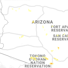
Arizona
| Local Time | Report Details |
|---|---|
| 2:20 PM MST | Quarter sized hail reported near Rio Rico, AZ, 54.6 miles S of Tucson, AZ, reported by trained spotter. |
| 2:30 PM MST | Quarter sized hail reported near Rio Rico, AZ, 54 miles S of Tucson, AZ, mostly dime size hail with some quarter size hail for a few minutes. |
| 2:35 PM MST | Ping Pong Ball sized hail reported near Rio Rico, AZ, 53.9 miles S of Tucson, AZ, 1.5 inches measured by a caliber measuring tool. |
| 4:10 PM MST | Quarter sized hail reported near Vail, AZ, 20.1 miles ESE of Tucson, AZ |
| 4:31 PM MST | Quarter sized hail reported near Tucson, AZ, 13 miles ESE of Tucson, AZ, near bilby and houghton. |
| 4:33 PM MST | Quarter sized hail reported near Tucson, AZ, 13 miles ESE of Tucson, AZ, measured 1 inch hail near the intersection of houghton rd and poorman rd. |
| 4:35 PM MST | Ping Pong Ball sized hail reported near Tucson, AZ, 13 miles ESE of Tucson, AZ, spotter reported measured 1.5 inch hail near the intersection of bilby rd and houghton rd. |
| 4:37 PM MST | Quarter sized hail reported near Tucson, AZ, 12.7 miles ESE of Tucson, AZ, near drexel and houghton. |
| 4:47 PM MST | Quarter sized hail reported near Tucson, AZ, 6.5 miles ESE of Tucson, AZ, near ironwood east of craycroft. |
| 4:49 PM MST | Quarter sized hail reported near Tucson, AZ, 6.8 miles ESE of Tucson, AZ, photo on twitter at golf links and wilmot. |
| 4:52 PM MST | Quarter sized hail reported near Tucson, AZ, 9.2 miles ESE of Tucson, AZ, public reported 1 inch hail near the intersection of pantano rd and escalante rd. |
| 5:20 PM MST | Quarter sized hail reported near Green Valley, AZ, 26.3 miles S of Tucson, AZ |
| 5:25 PM MST | Quarter sized hail reported near Green Valley, AZ, 23.7 miles S of Tucson, AZ, spotter reported 1 inch hail in green valley. |
| 5:25 PM MST | Quarter sized hail reported near Green Valley, AZ, 28.5 miles S of Tucson, AZ, corrects previous hail report from 2 s green valley. mping report. |
| 5:25 PM MST | Ping Pong Ball sized hail reported near Green Valley, AZ, 25.6 miles S of Tucson, AZ, public report received of hail between half dollar and ping pong ball size hail near the intersection of continental rd and interstate 19 in green valley. |
| 5:25 PM MST | Public report received of a highway sign blown over at the continental road exit off interstate 1 in pima county AZ, 25.6 miles S of Tucson, AZ |
| 5:25 PM MST | Corrects previous tstm wnd dmg report from 2 sse green valley. palo verdes and mesquite trees down on i-19 frontage road. branches 6in in diameter and larger snapped of in pima county AZ, 27 miles S of Tucson, AZ |
| 5:46 PM MST | Palo verdes and mesquite trees down on i-19 frontage road. branches 6in in diameter and larger snapped off and blocking roa in pima county AZ, 27 miles S of Tucson, AZ |
| 5:47 PM MST | Quarter sized hail reported near Green Valley, AZ, 28.5 miles S of Tucson, AZ, mping report. |
| 6:22 PM MST | Corrects previous tstm wnd gst report from 4 ne east mesa. roof tiles blown from a house due to winds measured at 65 mph by a home weather statio in maricopa county AZ, 25.8 miles E of Phoenix, AZ |
| 6:30 PM MST | Mesonet station srp20 at bartlett lake measured winds at 60 mp in maricopa county AZ, 36.3 miles NE of Phoenix, AZ |
| 6:40 PM MST | Mesonet station srp19 16.2 ne carefree (srp) measured 58 mph wind in maricopa county AZ, 42.3 miles NNE of Phoenix, AZ |
| 7:42 PM MST | Corrects previous non-tstm wnd gst report from sky harbor airport. asos station kphx phoenix... winds measured at 61 mp in maricopa county AZ, 3.5 miles ESE of Phoenix, AZ |
| 9:20 PM MST | Power lines down and debris on harquahala valley rd near i-10 exit 81. time estimated from rada in maricopa county AZ, 62.8 miles W of Phoenix, AZ |
Montana
| Local Time | Report Details |
|---|---|
| 4:47 PM MDT | Mesonet station brrm8 brenner raws station elevation: 6630 f in beaverhead county MT, 35.6 miles ESE of Salmon, ID |
Colorado
| Local Time | Report Details |
|---|---|
| 5:15 PM MDT | Corrects previous tstm wnd dmg report from 8 s wild horse. delayed report received via social media. possible wind driven hail damage to siding on a house reported alon in cheyenne county CO, 93.2 miles ENE of Pueblo, CO |
Nevada
| Local Time | Report Details |
|---|---|
| 4:40 PM PDT | A thunderstorm wind gust of 62 mph was measured at allegiant stadium at 440 p in clark county NV, 6.1 miles SSW of Las Vegas, NV |
| 7:54 PM PDT | Station tonopah airport (ktph)... elevation 5426 fee in nye county NV, 144.2 miles SW of Ely, NV |
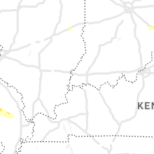
Missouri
| Local Time | Report Details |
|---|---|
| 8:12 PM CDT | Trees and powerlines down on county road 125 south of u.s. highway 60 and west of state route c. large tree blocking another part of state route c... plus other tree da in carter county MO, 53.3 miles SSE of Salem, MO |
| 10:17 PM CDT | Canopy blown awa in bollinger county MO, 21.4 miles W of Cape Girardeau, MO |
| 10:30 PM CDT | Tree and power lines down on county road 307 in stoddard county MO, 24.9 miles SW of Cape Girardeau, MO |
Kansas
| Local Time | Report Details |
|---|---|
| 7:55 PM MDT | Awos station k3k3 syracus in hamilton county KS, 47.9 miles W of Garden City, KS |
| 10:14 PM CDT | Mesonet station k36k kearny county airpor in kearny county KS, 21.1 miles W of Garden City, KS |
| 10:33 PM CDT | Asos station kgck garden cit in finney county KS, 9 miles ESE of Garden City, KS |
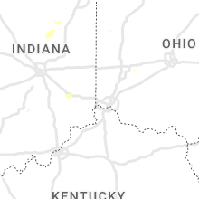
Indiana
| Local Time | Report Details |
|---|---|
| 1:15 AM EDT | Tree limbs downe in hamilton county IN, 14.2 miles N of Indianapolis, IN |
Connect with Interactive Hail Maps