

Hail Map for Thursday, July 19, 2012

Number of Impacted Households on 7/19/2012
0
Impacted by 1" or Larger Hail
0
Impacted by 1.75" or Larger Hail
0
Impacted by 2.5" or Larger Hail
Square Miles of Populated Area Impacted on 7/19/2012
0
Impacted by 1" or Larger Hail
0
Impacted by 1.75" or Larger Hail
0
Impacted by 2.5" or Larger Hail


Cities Most Affected by Hail Storms of 7/19/2012
| Hail Size | Demographics of Zip Codes Affected | ||||||
|---|---|---|---|---|---|---|---|
| City | Count | Average | Largest | Pop Density | House Value | Income | Age |
| Arvilla, ND | 1 | 1.75 | 1.75 | 4 | $58k | $28.1k | 47.4 |
| Elizabethtown, KY | 1 | 1.75 | 1.75 | 314 | $96k | $39.5k | 37.8 |
Hail and Wind Damage Spotted on 7/19/2012
Filter by Report Type:Hail ReportsWind Reports
States Impacted
Illinois, Kentucky, Alabama, Arkansas, Kansas, North Carolina, West Virginia, Pennsylvania, South Carolina, Mississippi, Missouri, Indiana, North Dakota, Maryland, Florida, Virginia, South Dakota, Tennessee, Oklahoma, Oregon, LouisianaIllinois
| Local Time | Report Details |
|---|---|
| 8:15 AM CDT | Delayed report. several large tree limbs down. garden plants flattened. time estimate in lawrence county IL, 51.7 miles NNW of Evansville, IN |
Kentucky
| Local Time | Report Details |
|---|---|
| 11:05 AM EDT | Tree down on hwy. 1649 near casey county high school in casey county KY, 58.7 miles WSW of Irvine, KY |
| 1:00 PM EDT | Three trees down on sadieville road in scott county KY, 48.1 miles S of Cincinnati, OH |
| 2:20 PM EDT | At winchester mesonet sit in clark county KY, 26.7 miles NNW of Irvine, KY |
| 2:30 PM EDT | Trees down on winchester road outside of mount sterlin in montgomery county KY, 24.9 miles N of Irvine, KY |
| 2:40 PM EDT | Kentucky mesonet recorded gust to 60 mp in bath county KY, 28.7 miles NNE of Irvine, KY |
| 2:45 PM EDT | Tree down on cow branch. time estimated from rada in morgan county KY, 45.2 miles ENE of Irvine, KY |
| 2:45 PM EDT | Tree down on highway in morgan county KY, 42.8 miles ENE of Irvine, KY |
| 2:55 PM EDT | Trees and large limbs down on tom stamper roa in menifee county KY, 28.1 miles NE of Irvine, KY |
| 3:20 PM EDT | Tree down on wilson branch road. time estimated from rada in wolfe county KY, 35.1 miles E of Irvine, KY |
| 3:40 PM EDT | Multiple trees down on aiken road and old frankfort pike in woodford county KY, 49 miles NW of Irvine, KY |
| 3:55 PM EDT | Trees down on highway 5 in lee county KY, 21.1 miles ESE of Irvine, KY |
| 4:20 PM EDT | Trees down on highway 979 along mud creek. time estimated from rada in floyd county KY, 66.3 miles NNW of Bristol, TN |
| 4:22 PM EDT | In the area of jacks creek pike and spears road....multiple large diameter trees down and a barn with roof damag in fayette county KY, 35.4 miles NW of Irvine, KY |
| 4:23 PM EDT | Trees down on laurel fork of lost creek. time estimated from radar in perry county KY, 49.6 miles ESE of Irvine, KY |
| 4:28 PM EDT | Trees down at chimney rock. time estimated from rada in perry county KY, 52.2 miles SE of Irvine, KY |
| 4:28 PM EDT | Trees down on lick branch at combs. time estimated from rada in perry county KY, 52.2 miles SE of Irvine, KY |
| 4:28 PM EDT | Trees down on briar fork at willard. time estimated from rada in perry county KY, 49.6 miles SE of Irvine, KY |
| 4:30 PM EDT | Trees down... transformers blow in jessamine county KY, 35.4 miles WNW of Irvine, KY |
| 4:56 PM EDT | Trees dow in madison county KY, 25.2 miles WNW of Irvine, KY |
| 4:56 PM EDT | Tree blocking tates creek road in madison county KY, 22.7 miles WNW of Irvine, KY |
| 5:00 PM EDT | Trees down over much of northwest madison count in madison county KY, 17.5 miles W of Irvine, KY |
| 5:05 PM EDT | Tree blocking lancaster roa in madison county KY, 16.2 miles W of Irvine, KY |
| 5:07 PM EDT | Spotter driving on route 119 reported a few trees down in harlan county KY, 52.8 miles WNW of Bristol, TN |
| 5:46 PM EDT | Tree across highway 42 near buckley lan in oldham county KY, 29.9 miles NNE of Louisville, KY |
| 5:46 PM EDT | Fire rescue equipment is being blocked by downed trees on highway 1793 near rose island roa in oldham county KY, 30.2 miles N of Louisville, KY |
| 5:47 PM EDT | Quarter sized hail reported near Goshen, KY, 29.9 miles NNE of Louisville, KY, 3 4 to 1 inch hail falling in goshen |
| 6:00 PM EDT | Trees dwon on sand gap roa in jackson county KY, 16.4 miles SSW of Irvine, KY |
| 6:00 PM EDT | Trees down on wind cave roa in jackson county KY, 13.3 miles S of Irvine, KY |
| 6:00 PM EDT | Barn blown down in madison county KY, 10.2 miles WSW of Irvine, KY |
| 6:05 PM EDT | Quarter sized hail reported near Carrollton, KY, 48.5 miles SW of Cincinnati, OH, time estimated from radar. |
| 6:06 PM EDT | Trees down on kelly roa in jackson county KY, 21.5 miles S of Irvine, KY |
| 6:10 PM EDT | Multiple trees down near highway 1694 in oldham county KY, 32.1 miles NNE of Louisville, KY |
| 6:19 PM EDT | Storm damage reported in oldham county KY, 25.4 miles NNE of Louisville, KY |
| 6:24 PM EDT | Large oak tree blown over on to two car in garrard county KY, 33.2 miles W of Irvine, KY |
| 5:30 PM CDT | A few tree limbs down and some shingles and trim blown off of a couple homes in crittenden county KY, 41.4 miles SSW of Evansville, IN |
| 5:40 PM CDT | Measured from ky mesonet mear the community of earlingto in hopkins county KY, 48.8 miles S of Evansville, IN |
| 5:40 PM CDT | Measured from ky mesonet near the community of earlingto in hopkins county KY, 48.8 miles S of Evansville, IN |
| 6:50 PM EDT | A few trees dow in shelby county KY, 31 miles ENE of Louisville, KY |
| 6:00 PM CDT | Trees down in ohio county KY, 47 miles SE of Evansville, IN |
| 6:02 PM CDT | Two large trees and powerlines downed in ohio county KY, 51.8 miles SE of Evansville, IN |
| 7:11 PM EDT | 7 large trees down near hemp ridge roa in shelby county KY, 33.9 miles ENE of Louisville, KY |
| 7:13 PM EDT | Measured at louisville international airpor in jefferson county KY, 16.1 miles N of Louisville, KY |
| 6:15 PM CDT | Extensive tree damage and downed power lines near sunnydale in ohio county KY, 51.7 miles SE of Evansville, IN |
| 6:15 PM CDT | Trees down near sunnydale in ohio county KY, 51.7 miles SE of Evansville, IN |
| 6:18 PM CDT | Quarter sized hail reported near Princeton, KY, 48.7 miles SSW of Evansville, IN, quarter size hail reported west of beulah. |
| 7:19 PM EDT | Tree down on locust fork road in scott county KY, 55.9 miles NW of Irvine, KY |
| 6:25 PM CDT | Extensive tree damage and downed power lines in ohio county KY, 52.1 miles SE of Evansville, IN |
| 7:28 PM EDT | Widespread wind damage in lawrenceburg from multiple sources. a 35 foot maple tree was downed. a trampoline was thrown over a fence. power outages were widesprea in anderson county KY, 45.2 miles E of Louisville, KY |
| 7:28 PM EDT | Ten trees downed on mitchell lane and cooks lane in spencer county KY, 28.2 miles E of Louisville, KY |
| 7:32 PM EDT | Trees down along hwy 1803...near jct of co203 and also ky1304. power outages reported around the area. local dispatch has been notified. time est from rada in knox county KY, 52 miles S of Irvine, KY |
| 6:32 PM CDT | Quarter sized hail reported near Morgantown, KY, 64.5 miles SE of Evansville, IN |
| 6:33 PM CDT | Trees down in ohio county KY, 51.5 miles ESE of Evansville, IN |
| 6:35 PM CDT | Quarter sized hail reported near Morgantown, KY, 66.9 miles SE of Evansville, IN, near eden. |
| 6:35 PM CDT | Quarter sized hail reported near Morgantown, KY, 67 miles SE of Evansville, IN, one inch hail and 50 mph winds reported by a trained spotter. |
| 7:36 PM EDT | Tree down on coleman lane in scott county KY, 45.6 miles NW of Irvine, KY |
| 6:39 PM CDT | Late report. roof blown off of home located along lake breshear in northwest christian count in christian county KY, 57.9 miles S of Evansville, IN |
| 6:39 PM CDT | Update. micorburst with 95 mph winds. 500 yards wide and one half mile long. at lake bashear a lake front home had roofing from the front porch and the front of the hom in christian county KY, 57.9 miles S of Evansville, IN |
| 7:48 PM EDT | Trees down on warrens loo in knox county KY, 52.4 miles S of Irvine, KY |
| 7:52 PM EDT | Trees down in nelson county KY, 27.8 miles ESE of Louisville, KY |
| 7:58 PM EDT | Trees down on templin avenue in nelson county KY, 16.5 miles SE of Louisville, KY |
| 8:00 PM EDT | Trees down on road in larue county KY, 33.7 miles SSE of Louisville, KY |
| 8:05 PM EDT | A tree fell across a power line on bubble link drive. at another location in harrodsburg...a large branch fell across a power lin in mercer county KY, 48.2 miles W of Irvine, KY |
| 7:05 PM CDT | Section of barn blown off just west of tow in christian county KY, 64 miles S of Evansville, IN |
| 7:05 PM CDT | Roof off barn on rader hollow road. numerous trees down northwest of munfordvill in hart county KY, 47.3 miles SSW of Louisville, KY |
| 8:08 PM EDT | Trees down on highway 343 in knox county KY, 59 miles S of Irvine, KY |
| 7:10 PM CDT | Two trees fell across roads near cave city in barren county in barren county KY, 60 miles SSW of Louisville, KY |
| 7:10 PM CDT | Trailers damaged by multiple trees down in butler county KY, 70.5 miles SE of Evansville, IN |
| 8:10 PM EDT | Trees down on greer lane in nelson county KY, 21.6 miles SE of Louisville, KY |
| 7:15 PM CDT | Barn with significant structural damage at 728 priceville road. outbuilding was flattened at 6840 priceville road. widespread trees dow in hart county KY, 45 miles SSW of Louisville, KY |
| 7:15 PM CDT | Tree down on highway 1133 near blowtown road in grayson county KY, 54.4 miles SW of Louisville, KY |
| 7:24 PM CDT | Tree down blocking road on highway 1015 in edmonson county KY, 52.7 miles SSW of Louisville, KY |
| 8:28 PM EDT | Multiple trees down across the county in meade county KY, 25.3 miles W of Louisville, KY |
| 8:45 PM EDT | Golf Ball sized hail reported near Elizabethtown, KY, 21.5 miles SSW of Louisville, KY, on the wk parkway arount mile marker 125. |
| 8:47 PM EDT | Numerous trees down in audubon park. trees are blocking several road in jefferson county KY, 13.3 miles N of Louisville, KY |
| 7:51 PM CDT | Tree down on mammoth cave street in barren county KY, 60 miles SSW of Louisville, KY |
| 7:51 PM CDT | A tree fell across social band road 9 miles west of campbellsvill in green county KY, 45.4 miles SSE of Louisville, KY |
| 8:55 PM EDT | Storm damage reported in hardin county KY, 25.9 miles SW of Louisville, KY |
| 8:56 PM EDT | Trees down over much of the count in hardin county KY, 21.5 miles SSW of Louisville, KY |
| 8:56 PM EDT | Taylor county em reports widespread trees down in the eastern and northeastern portions of the county... relayed from the county road department in taylor county KY, 50.3 miles SE of Louisville, KY |
| 9:10 PM EDT | Trees down on herbert howell road and charlie ragland road...both near hodgenvill in larue county KY, 28.8 miles S of Louisville, KY |
| 8:10 PM CDT | Tree down on fairview church road in edmonson county KY, 67.4 miles SSW of Louisville, KY |
| 9:15 PM EDT | Ky highway 70 closed between highway 1649 and 1817 due to power line across the roa in casey county KY, 58.7 miles WSW of Irvine, KY |
| 8:16 PM CDT | Trees down on old munfordville road in north-central barren count in barren county KY, 64.7 miles SSW of Louisville, KY |
| 8:17 PM CDT | Light weight plane flipped and badly damaged. also trees down on property. used time of asos measured gust of 46 mph for repor in warren county KY, 58 miles NNE of Nashville, TN |
| 8:25 PM CDT | Storm damage reported in simpson county KY, 37.1 miles NNE of Nashville, TN |
| 8:25 PM CDT | 4 barns completely destroyed...3 others damaged with lots of trees down as well near intersection of ky 1048 and herbert hodges rd in metcalfe county KY, 59.2 miles S of Louisville, KY |
| 8:25 PM CDT | Two large grain bins damaged along rapids hickory flat road. trees downed in the area...one on a mobile hom in simpson county KY, 39 miles NNE of Nashville, TN |
| 8:35 PM CDT | Tree down at 900 millstown road... south of park cit in barren county KY, 69.2 miles SSW of Louisville, KY |
| 8:42 PM CDT | A tree fell along cane valley mill roa in adair county KY, 59.8 miles SSE of Louisville, KY |
| 8:47 PM CDT | Trees down countywid in metcalfe county KY, 69.7 miles S of Louisville, KY |
| 8:47 PM CDT | One tree reported down in summer shade in metcalfe county KY, 76.4 miles S of Louisville, KY |
| 8:47 PM CDT | Several trees down across adair county. one fell along bennett ridge road near green count in adair county KY, 63.8 miles SSE of Louisville, KY |
| 9:53 PM EDT | One tree down on west highway 80 in pulaski county KY, 60.9 miles SW of Irvine, KY |
| 8:54 PM CDT | Tree down on roseville road at dry fork in barren county KY, 65.6 miles NE of Nashville, TN |
| 10:02 PM EDT | One tree down on twin rivers drive in pulaski county KY, 60.5 miles SW of Irvine, KY |
| 9:04 PM CDT | Two trees fell across monroe county. one fell across celine road north of tompkinsvill in monroe county KY, 74.3 miles NE of Nashville, TN |
| 9:15 PM CDT | A tree fell across flippin lamb road east of flippi in monroe county KY, 66.9 miles NE of Nashville, TN |
| 11:23 PM EDT | One tree down on black oak road in whitley county KY, 46.4 miles NNW of Knoxville, TN |
Alabama
| Local Time | Report Details |
|---|---|
| 12:08 PM CDT | Probable 40 mph wind damaged the canopy overhanging gasoline pumps at a convenience store at the corner of grelot and knollwood driv in mobile county AL, 7.8 miles WSW of Mobile, AL |
| 7:10 PM CDT | Quarter sized hail reported near Leighton, AL, 10.8 miles SE of Florence, AL |
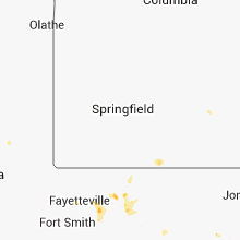
Arkansas
| Local Time | Report Details |
|---|---|
| 1:15 PM CDT | Trees and power lines were blown down...and three chicken houses had roof damag in independence county AR, 64.9 miles NNE of Little Rock, AR |
| 2:45 PM CDT | Several pieces of siding were blown off a hous in van buren county AR, 44.7 miles N of Little Rock, AR |
| 2:45 PM CDT | Numerous trees and power lines down in damascu in van buren county AR, 44.3 miles N of Little Rock, AR |
| 4:30 PM CDT | Large tree blown dow in carroll county AR, 52.4 miles S of Springfield, MO |
| 4:30 PM CDT | Quarter sized hail reported near Austin, AR, 25.3 miles ENE of Little Rock, AR |
| 4:31 PM CDT | Roof damage to home...several large trees down in carroll county AR, 52.4 miles S of Springfield, MO |
| 5:10 PM CDT | Tree fell and damaged a house in south harrison...and also brought power lines down. relayed by knwa in fayettevill in boone county AR, 67.5 miles S of Springfield, MO |
| 6:30 PM CDT | At county rd 5395 and hwy 74 junction...6 large trees snapped or uprooted. two hay barns destroyed in madison county AR, 46.9 miles NE of Fort Smith, AR |
| 6:40 PM CDT | Large tree limbs dow in washington county AR, 48.8 miles NNE of Fort Smith, AR |
| 7:20 PM CDT | Damage to bar in madison county AR, 50.6 miles NE of Fort Smith, AR |
| 7:45 PM CDT | Large maple tree laying across county roa in greene county AR, 71.7 miles NNW of Memphis, TN |
| 8:56 PM CDT | Damage to a house was reported in the town of ic in grant county AR, 21 miles SSW of Little Rock, AR |
Kansas
| Local Time | Report Details |
|---|---|
| 1:16 PM CDT | Storm damage reported in sedgwick county KS, 5.9 miles SE of Wichita, KS |
| 4:04 PM CDT | Storm damage reported in kingman county KS, 43 miles W of Wichita, KS |
North Carolina
| Local Time | Report Details |
|---|---|
| 2:45 PM EDT | One tree down in union mill in rutherford county NC, 57.6 miles NE of Greenville, SC |
| 3:00 PM EDT | One tree donw in cane creek are in rutherford county NC, 59.4 miles NE of Greenville, SC |
| 4:07 PM EDT | Tree down on shed at hill street in iredell county NC, 38.6 miles N of Charlotte, NC |
| 4:15 PM EDT | Tree down on concord ceffo r in person county NC, 51.8 miles NNW of Raleigh, NC |
| 4:15 PM EDT | Tree down on mcgehees mill rd near oak grov in person county NC, 51.1 miles NNW of Raleigh, NC |
| 4:45 PM EDT | 3 large trees down in area field in person county NC, 50.2 miles NNW of Raleigh, NC |
| 5:09 PM EDT | Large limbs down near pumpkin cente in lincoln county NC, 27.1 miles NW of Charlotte, NC |
| 6:00 PM EDT | Trees and powerlines down...relayed by amateur radi in cleveland county NC, 35.9 miles W of Charlotte, NC |
| 6:20 PM EDT | 2 trees down...jones ferry rd and old fayetteville rd. both caused power outage in orange county NC, 26.2 miles WNW of Raleigh, NC |
| 7:21 PM EDT | Nc 27 24 and lakewood rd tree downed power lines... multiple power outages in albemare - unknown origin in stanly county NC, 28.3 miles E of Charlotte, NC |
West Virginia
| Local Time | Report Details |
|---|---|
| 3:05 PM EDT | Tree down. time estimated by rada in cabell county WV, 37.2 miles W of Charleston, WV |
| 3:25 PM EDT | Phone lines down in parts of the city. timed from radar in cabell county WV, 27.7 miles WNW of Charleston, WV |
| 3:55 PM EDT | Tree down on main street. timed from rada in kanawha county WV, 10 miles WNW of Charleston, WV |
| 4:00 PM EDT | Tree down on chestnut rd in jefferson. timed from rada in kanawha county WV, 7.9 miles WNW of Charleston, WV |
| 4:05 PM EDT | Tree down on the west side of st. albans. time estimated by rada in kanawha county WV, 14.6 miles WNW of Charleston, WV |
| 4:10 PM EDT | Powerlines down on hillcrest dr. time estimated from rada in kanawha county WV, 0.5 miles E of Charleston, WV |
| 4:10 PM EDT | Trees knocked down power lines on willow wood r in kanawha county WV, 1.3 miles WSW of Charleston, WV |
| 4:10 PM EDT | Trees knocked down power lines on kearse av in kanawha county WV, 2.1 miles NNW of Charleston, WV |
| 4:20 PM EDT | Trees and powerlines down on new hope road. timed from rada in kanawha county WV, 9.6 miles ENE of Charleston, WV |
| 4:22 PM EDT | Tree dow in kanawha county WV, 14.6 miles SE of Charleston, WV |
Pennsylvania
| Local Time | Report Details |
|---|---|
| 3:46 PM EDT | Trees down in westmoreland county PA, 26 miles ESE of Pittsburgh, PA |
| 7:59 PM EDT | Half Dollar sized hail reported near Marysville, PA, 58.1 miles ESE of State College, PA |
South Carolina
| Local Time | Report Details |
|---|---|
| 4:09 PM EDT | Trees down on little eastatoee rd near highway 11 in pickens county SC, 14.7 miles WNW of Greenville, SC |
| 4:09 PM EDT | Trees down on highway 133 near highway 11 in pickens county SC, 17.6 miles WNW of Greenville, SC |
| 4:14 PM EDT | Trees and power lines down on highway 178 in pickens county SC, 9.6 miles NW of Greenville, SC |
| 5:50 PM EDT | Power lines down at parris bridge rd and mcswain rd in spartanburg county SC, 44.9 miles NE of Greenville, SC |
| 5:55 PM EDT | Trees down at turkey farm rd and fish camp rd in spartanburg county SC, 46.1 miles ENE of Greenville, SC |
| 5:55 PM EDT | Tree down on fish camp rd at parris bridge rd in spartanburg county SC, 43.4 miles ENE of Greenville, SC |
Mississippi
| Local Time | Report Details |
|---|---|
| 3:25 PM CDT | Power lines were downed along overstreet avenue in hinds county MS, 2.8 miles NW of Jackson, MS |
| 3:25 PM CDT | A tree and lines were downed across old rice road in madison county MS, 14.6 miles NNE of Jackson, MS |
| 4:45 PM CDT | Minor roof damage. small metal pump house building also blown over. reported by humphreys county s. in humphreys county MS, 63.3 miles NNW of Jackson, MS |
| 5:35 PM CDT | 18 wheeler blown over in humphreys county MS, 62 miles NNW of Jackson, MS |
Missouri
| Local Time | Report Details |
|---|---|
| 3:34 PM CDT | A boat dock on tablerock lake was damaged by a downburst to the southwest of holliste in taney county MO, 42.7 miles S of Springfield, MO |
| 4:30 PM CDT | A downburst downed numerous trees along with power lines along highway 5 south of gainesville. the downed power lines caused a fire which destroyed two homes. time was in ozark county MO, 68.3 miles SE of Springfield, MO |
Indiana
| Local Time | Report Details |
|---|---|
| 4:50 PM EDT | Trees and powerlines down in washington county IN, 48.9 miles NNW of Louisville, KY |
| 4:51 PM EDT | Utility line down. relayed by knox county em in knox county IN, 67 miles NNE of Evansville, IN |
| 5:07 PM EDT | Ping Pong Ball sized hail reported near Jeffersonville, IN, 23.8 miles N of Louisville, KY, walnut sized hail reported by espotter |
| 5:35 PM EDT | Pine tree downe in scott county IN, 56 miles N of Louisville, KY |
| 5:38 PM EDT | Ping Pong Ball sized hail reported near Charlestown, IN, 32 miles N of Louisville, KY |
| 5:46 PM EDT | Trees and powerlines down near highland road in washington county IN, 47.9 miles NNW of Louisville, KY |
| 5:46 PM EDT | Quarter sized hail reported near Charlestown, IN, 30.2 miles N of Louisville, KY, windows broken out of homes near victory lane by hail at least quarter size. |
| 5:55 PM EDT | Power pole broken in hal in jefferson county IN, 52.3 miles NNE of Louisville, KY |
| 6:26 PM EDT | Smaller tree down... time approximated in clinton county IN, 45.2 miles NW of Indianapolis, IN |
| 6:30 PM EDT | Several trees and power lines down city wide in salem in washington county IN, 47.1 miles NNW of Louisville, KY |
| 6:35 PM EDT | Quarter sized hail reported near Frankfort, IN, 40.2 miles NNW of Indianapolis, IN, located at state road 158 and interstate 65 |
| 7:04 PM EDT | Power lines dow in dubois county IN, 44.3 miles NE of Evansville, IN |
| 7:35 PM EDT | 2 trees blocking williamson road in crawford county IN, 49.2 miles WNW of Louisville, KY |
| 7:40 PM EDT | Trees 18 to 24 inches in diameter down on smith and lenard roads. corn flattened. time estimate in owen county IN, 40 miles SW of Indianapolis, IN |
| 7:40 PM EDT | Tree down. size unknow in owen county IN, 43.5 miles SW of Indianapolis, IN |
| 7:56 PM EDT | Located at mount comfort airport in hancock county IN, 14.5 miles ENE of Indianapolis, IN |
| 7:56 PM EDT | Trees down in the leavenworth are in crawford county IN, 37.5 miles WNW of Louisville, KY |
| 8:00 PM EDT | Located at cr150w cr150s in hancock county IN, 16.5 miles E of Indianapolis, IN |
| 8:00 PM EDT | 2-inch diameter live tree snapped at base in hancock county IN, 15.3 miles NE of Indianapolis, IN |
| 8:05 PM EDT | Storm damage reported in hancock county IN, 15.3 miles NE of Indianapolis, IN |
| 8:05 PM EDT | 6-inch diameter tree limb snapped off in hancock county IN, 15.3 miles NE of Indianapolis, IN |
| 9:55 PM EDT | Several trees down...along with power lines...west of brookvill in franklin county IN, 36.4 miles NW of Cincinnati, OH |
| 10:15 PM CDT | Late report. damage to north high school sports complex. several bleachers and stadium lights damaged. parked semi trailer used as storage blown over. top of trees snap in vanderburgh county IN, 1.3 miles E of Evansville, IN |
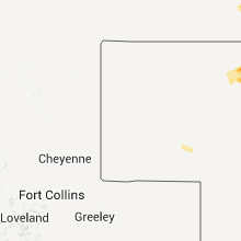
North Dakota
| Local Time | Report Details |
|---|---|
| 3:55 PM CDT | Several large trees...up to 2 ft diameter...were broken down. widespread tree and roof damage reported in town... with sheet metal roofing and shingles blown about. lot in ramsey county ND, 23.4 miles N of Devils Lake, ND |
| 3:55 PM CDT | Several large trees...up to 2ft diasmeter...were broken down. widespread tree and roof damag in ramsey county ND, 23.4 miles N of Devils Lake, ND |
| 4:10 PM CDT | Very strong winds occurred between 400 and 410 pm cdt across central sullivan township... accompanied with pea sized hail and 0.40 inches of rain. some area crops were in ramsey county ND, 20.1 miles N of Devils Lake, ND |
| 5:41 PM CDT | Storm damage reported in mountrail county ND, 43.8 miles WSW of Minot, ND |
| 6:00 PM CDT | Golf Ball sized hail reported near Arvilla, ND, 62.3 miles E of Devils Lake, ND |
| 6:05 PM CDT | Quarter sized hail reported near Emerado, ND, 66.6 miles E of Devils Lake, ND |
| 6:10 PM CDT | Winds estimated near turtle river state par in grand forks county ND, 64.6 miles E of Devils Lake, ND |
| 6:10 PM CDT | Quarter sized hail reported near Makoti, ND, 24.7 miles WSW of Minot, ND, hail lasted 610 pm to 630 pm cdt. also 0.60 inches of rain. |
| 6:25 PM CDT | Large 18 inch diameter trees were snapped in west central union township... leaving 3 to 4 foot stumps. one 85 ft tall tree fell towards the west and took down the set in grand forks county ND, 63.9 miles NNW of Fargo, ND |
| 6:30 PM CDT | Tree damage. branches down taking power lines down with the in traill county ND, 62.2 miles NNW of Fargo, ND |
| 6:30 PM CDT | Tree damage. branches down taking power lines down with them. first reported via amateur radio then confirmed via utility compan in traill county ND, 62.2 miles NNW of Fargo, ND |
| 6:35 PM CDT | Quarter sized hail reported near Buxton, ND, 53.9 miles NNW of Fargo, ND, mostly 1/4 to 3/8 inch diameter hail |
| 7:44 PM CDT | Storm damage reported in mclean county ND, 41 miles S of Minot, ND |
| 7:46 PM CDT | Several trees down and uprooted. estimated tree diameters up to 25 inches uprooted with up to 18 inch diameter branches broken. reported by cory nordquis in mclean county ND, 40.9 miles S of Minot, ND |
| 9:15 PM CDT | Quarter sized hail reported near Rocklake, ND, 60.4 miles NNW of Devils Lake, ND |
| 3:31 AM CDT | Storm damage reported in stutsman county ND, 81.4 miles S of Devils Lake, ND |
Maryland
| Local Time | Report Details |
|---|---|
| 7:06 PM EDT | Storm damage reported in baltimore city county MD, 2.1 miles SE of Baltimore, MD |
| 9:23 PM EDT | Trees down and damage to pavilion on 23000 block of frederick rd in montgomery county MD, 36.7 miles W of Baltimore, MD |
| 9:44 PM EDT | Large tree down on norbeck road near gude d in montgomery county MD, 31.2 miles WSW of Baltimore, MD |
| 9:44 PM EDT | Large tree down on norbeck road near gude d in montgomery county MD, 36.7 miles W of Baltimore, MD |
| 9:57 PM EDT | Tree down on east west highway near beach driv in montgomery county MD, 31.9 miles SW of Baltimore, MD |
Florida
| Local Time | Report Details |
|---|---|
| 7:10 PM EDT | Wrist-size limbs from old oak tree down in roa in orange county FL, 16.5 miles E of Orlando, FL |
Virginia
| Local Time | Report Details |
|---|---|
| 7:10 PM EDT | Dispatch reported one tree down off leigh av in lee county VA, 46.8 miles WNW of Bristol, TN |
| 7:15 PM EDT | Dispatch reported a tree dow in lee county VA, 46.4 miles WNW of Bristol, TN |
| 7:15 PM EDT | Dispatch reported one tree dow in scott county VA, 29 miles W of Bristol, TN |
South Dakota
| Local Time | Report Details |
|---|---|
| 6:20 PM CDT | Tractor trailer blown over on i90 in jones county SD, 33.2 miles SSW of Pierre, SD |
| 6:30 PM CDT | Storm damage reported in todd county SD, 30.6 miles N of Valentine, NE |
| 6:50 PM CDT | Storm damage reported in todd county SD, 35.9 miles NNE of Valentine, NE |
| 7:21 PM CDT | Storm damage reported in tripp county SD, 49.8 miles NE of Valentine, NE |
| 7:50 PM CDT | Also reported 10 to 15 minutes of pea size hail along with the wind in lyman county SD, 53.6 miles SSE of Pierre, SD |
| 8:15 PM CDT | Storm damage reported in lyman county SD, 74.2 miles SE of Pierre, SD |
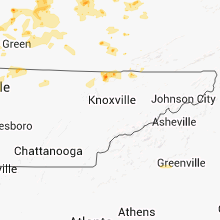
Tennessee
| Local Time | Report Details |
|---|---|
| 7:30 PM EDT | Several trees down between church hill and rogersvill in hawkins county TN, 27.5 miles W of Bristol, TN |
| 8:00 PM EDT | Couple of trees down in the duck creek are in hancock county TN, 53.5 miles NE of Knoxville, TN |
| 8:50 PM EDT | Dispatch reported a few areas with trees and power lines dow in claiborne county TN, 39.9 miles NNE of Knoxville, TN |
| 9:10 PM EDT | Dispatch reported a tree down of owl hole gap roa in grainger county TN, 26.6 miles NE of Knoxville, TN |
| 8:24 PM CDT | 2 industrial buildings were damaged along fred white d in sumner county TN, 32.5 miles NNE of Nashville, TN |
| 9:35 PM EDT | Dispatch reported a few trees dow in claiborne county TN, 34.9 miles NNE of Knoxville, TN |
| 9:35 PM EDT | Dispatch reported a few trees down in new tazewel in claiborne county TN, 37.6 miles NNE of Knoxville, TN |
| 9:40 PM EDT | Dispatch reported multiple trees dow in campbell county TN, 44.3 miles NNW of Knoxville, TN |
| 8:45 PM CDT | Resident near the intersection of boyles road and pleasant grove road estimated winds 60-70 mp in robertson county TN, 23.3 miles N of Nashville, TN |
| 9:02 PM CDT | 18 inch diameter tree blown down south of springfield in robertson county TN, 18.9 miles NNW of Nashville, TN |
| 9:02 PM CDT | Several trees snapped or blown down in the windmere estates subdivision south of springfield with one tree falling on a hous in robertson county TN, 18.9 miles NNW of Nashville, TN |
| 9:05 PM CDT | Trees down along hwy 25 in cottontown in sumner county TN, 24.6 miles NNE of Nashville, TN |
| 9:18 PM CDT | Estimated winds in excess of 60 mph on main street in goodlettsvill in davidson county TN, 12 miles NNE of Nashville, TN |
| 10:25 PM EDT | Dispatch reported multiple trees dow in campbell county TN, 30.6 miles NNW of Knoxville, TN |
| 9:25 PM CDT | 107 foot tall oak tree was blown down on forest retreat road in hendersonville. this 150 to 200 year old tree is reportedly the oldest in sumner county and likely the s in sumner county TN, 13 miles NE of Nashville, TN |
| 9:26 PM CDT | Trees down and a trampoline flipped in cheatham county TN, 16.7 miles NW of Nashville, TN |
| 9:28 PM CDT | Roof was blown off a modular home on red binkley road. numerous trees were blown down including some blocking road in cheatham county TN, 20.6 miles NNW of Nashville, TN |
| 9:30 PM CDT | Trees and power lines blown down in ashland city in cheatham county TN, 17.5 miles WNW of Nashville, TN |
| 9:30 PM CDT | Trees snapped in two by target in hendersonville in sumner county TN, 14.1 miles NE of Nashville, TN |
| 9:40 PM CDT | Tree blown down in lafayette in macon county TN, 48.3 miles ENE of Nashville, TN |
| 9:40 PM CDT | Several trees snapped and blown down in joelton in davidson county TN, 11.1 miles NNW of Nashville, TN |
| 9:42 PM CDT | Trees blown down on cemetery street near hendersonvill in sumner county TN, 13.1 miles NE of Nashville, TN |
| 9:43 PM CDT | Around a dozen trees were blown down. shute lane was blocked by fallen tree in davidson county TN, 10.3 miles ENE of Nashville, TN |
| 9:45 PM CDT | Report of trees blown down on hood road near white hous in robertson county TN, 21 miles NNE of Nashville, TN |
| 9:53 PM CDT | Tree blown down on weeping elm road in wilson county TN, 14.9 miles ENE of Nashville, TN |
| 10:03 PM CDT | Nws storm survey found microburst wind damage across eastern mount juliet. scattered trees and large tree limbs were snapped or blown down on several roadways including in wilson county TN, 15.2 miles E of Nashville, TN |
| 10:15 PM CDT | 8 inch branch blown off tree in belle mead in davidson county TN, 6.5 miles SW of Nashville, TN |
| 10:15 PM CDT | Two trees blown down along lebanon pike at highland view road in hermitage in davidson county TN, 9.9 miles ENE of Nashville, TN |
| 10:29 PM CDT | Numerous trees and power lines blown down across davidson county in davidson county TN, 8.1 miles S of Nashville, TN |
| 10:30 PM CDT | Trees down across powerlines in multiple locations along belle meade blv in davidson county TN, 6.5 miles SW of Nashville, TN |
| 10:30 PM CDT | Power line down...and sparking...in east nashvill in davidson county TN, 0.2 miles NNW of Nashville, TN |
| 11:35 PM EDT | Dispatch reported multiple trees down across the northern half of the county near jellico...peabody...and stinking cree in campbell county TN, 44.3 miles NNW of Knoxville, TN |
| 12:20 AM CDT | Tree uprooted on preston drive in montgomery county TN, 44 miles NW of Nashville, TN |
| 12:25 AM CDT | Trees blown down on velmas way. several other trees and tree limbs blown down in and around clarksville in montgomery county TN, 43.7 miles NW of Nashville, TN |
| 12:45 AM CDT | Numerous trees and power lines were blown down across montgomery county. 1843 customers without power at peak of storm outside of clarksville city limits per cem in montgomery county TN, 37.5 miles WNW of Nashville, TN |
| 1:00 AM CDT | Trees and fences blown down in chapmansboro in cheatham county TN, 26 miles WNW of Nashville, TN |
Oklahoma
| Local Time | Report Details |
|---|---|
| 6:54 PM CDT | Thunderstorm winds estimated to 65 mph on west side of haskell. 4 inch diameter tree snapped and other tree limb damag in muskogee county OK, 27.7 miles SE of Tulsa, OK |
| 7:29 PM CDT | Power pole damaged at 71st street and memorial drive. traffic being diverte in tulsa county OK, 4.3 miles ESE of Tulsa, OK |
| 7:33 PM CDT | Panel of 6 foot privacy fenced downed by thunderstorm winds at 145th and south yale ave. relayed by medi in tulsa county OK, 15.7 miles SSE of Tulsa, OK |
| 7:45 PM CDT | Storm damage reported in major county OK, 70.8 miles NNW of Oklahoma City, OK |
| 8:40 PM CDT | Measured wind gust of 64 mph at the haskell mesone in muskogee county OK, 33.9 miles SE of Tulsa, OK |
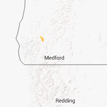
Oregon
| Local Time | Report Details |
|---|---|
| 7:13 PM PDT | Quarter sized hail reported near Glendale, OR, 38.9 miles NW of Medford, OR, quarter size hail estimated by spotter. |
Louisiana
| Local Time | Report Details |
|---|---|
| 11:50 PM CDT | Trees downed by suspected tstm microburst. john hardy road and e lafayette stree in vermilion county LA, 18.3 miles SSW of Lafayette, LA |
Connect with Interactive Hail Maps