

Hail Map for Tuesday, July 19, 2022

Number of Impacted Households on 7/19/2022
0
Impacted by 1" or Larger Hail
0
Impacted by 1.75" or Larger Hail
0
Impacted by 2.5" or Larger Hail
Square Miles of Populated Area Impacted on 7/19/2022
0
Impacted by 1" or Larger Hail
0
Impacted by 1.75" or Larger Hail
0
Impacted by 2.5" or Larger Hail

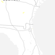


Cities Most Affected by Hail Storms of 7/19/2022
| Hail Size | Demographics of Zip Codes Affected | ||||||
|---|---|---|---|---|---|---|---|
| City | Count | Average | Largest | Pop Density | House Value | Income | Age |
Hail and Wind Damage Spotted on 7/19/2022
Filter by Report Type:Hail ReportsWind Reports
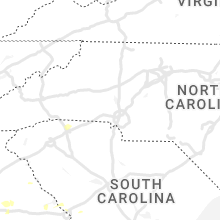
States Impacted
Georgia, Mississippi, South Carolina, Maine, New Mexico, Florida, North Carolina, New York, Utah, Arizona, TexasGeorgia
| Local Time | Report Details |
|---|---|
| 8:57 AM EDT | *** 1 inj *** tree down on car at eleanor terrace nw and eleanor ct nw in fulton county GA, 5.6 miles WNW of Atlanta, GA |
| 1:20 PM EDT | Approximately 2000 customers without power across southern limits of cordele due to trees down on powerline in crisp county GA, 61.6 miles WNW of Douglas, GA |
| 1:22 PM EDT | Tree down on powerlines on buford r in crisp county GA, 57.3 miles WNW of Douglas, GA |
| 3:54 PM EDT | Multiple reports of trees down within the city of baxley along zoar rd... kennedy rd... harvey street and north brobston st. time estimate based on rada in appling county GA, 35 miles ENE of Douglas, GA |
| 4:15 PM EDT | Tree down on powerlines on village entrance r in douglas county GA, 25.3 miles W of Atlanta, GA |
| 4:17 PM EDT | Tree down on car in parking lot of business on 9500 block of hwy 5. no injurie in douglas county GA, 21.3 miles W of Atlanta, GA |
| 4:44 PM EDT | Tree down on house at intersection of lavender dr nw and chappell rd n in fulton county GA, 2.4 miles WNW of Atlanta, GA |
| 4:55 PM EDT | Several trees down within the zebulon city limit in pike county GA, 44.8 miles S of Atlanta, GA |
| 4:56 PM EDT | Tree down on house on drewery st n in fulton county GA, 2.8 miles NE of Atlanta, GA |
| 5:08 PM EDT | Thomas county dispatch reported multiple power outages in the thomasville area. a thomasville power outage map confirmed 673 customers losing power at 5:08 pm ed in thomas county GA, 34.9 miles NNE of Tallahassee, FL |
| 5:20 PM EDT | Two trees down within the williamson city limit in pike county GA, 39.2 miles S of Atlanta, GA |
| 5:45 PM EDT | Tree down at intersection of weldon rd and n hwy 2 in coweta county GA, 23.5 miles SW of Atlanta, GA |
| 6:24 PM EDT | Several trees downed along hawkins academy rd. em reported road closed due to trees and power lines downe in walton county GA, 43.3 miles E of Atlanta, GA |
| 6:25 PM EDT | Several trees down along amber stapp road in walton county GA, 42.1 miles E of Atlanta, GA |
| 6:46 PM EDT | Several trees down along c m copelan r in greene county GA, 63.1 miles E of Atlanta, GA |
Mississippi
| Local Time | Report Details |
|---|---|
| 12:21 PM CDT | Emergency manager reported trees down in and around caledoni in lowndes county MS, 31.9 miles ENE of Starkville, MS |
South Carolina
| Local Time | Report Details |
|---|---|
| 3:44 PM EDT | South carolina highway patrol reported a tree down on interstate 526 near mile marker 14 just before the westmoreland bridge. broadcast media showed a large dead pine t in charleston county SC, 26 miles S of Charleston, SC |
| 5:48 PM EDT | Schp reported a tree down near the intersection of daley road and pelot street. time determined from radar dat in hampton county SC, 42.3 miles NNW of Savannah, GA |
| 6:00 PM EDT | Tree down on house off lister cour in spartanburg county SC, 38.1 miles ENE of Greenville, SC |
| 6:02 PM EDT | Trees reported down just sw of boiling spring in spartanburg county SC, 36.5 miles ENE of Greenville, SC |
| 6:42 PM EDT | Jasper county 911 dispatched a deputy to a fallen tree on old sheldon church road. traffic map indicates that the tree was down just north of the intersection with twic in beaufort county SC, 41.5 miles NNE of Savannah, GA |
| 6:50 PM EDT | Trees reported down in roebuc in spartanburg county SC, 36.5 miles E of Greenville, SC |
| 6:52 PM EDT | Schp reported a tree down near the intersection of white hall road and pynes community road. time determined from radar dat in colleton county SC, 49.5 miles NNE of Savannah, GA |
| 7:10 PM EDT | Trees reported down north of jonesvill in union county SC, 52.4 miles E of Greenville, SC |
| 8:25 PM EDT | Edgefield county dispatch reported multiple trees down on woodlawn road. time estimated by rada in edgefield county SC, 10.5 miles NNW of Augusta, GA |
| 9:00 PM EDT | Sc highway patrol reported a tree down blocking the road on augusta rd (sc 421). time estimated by rada in aiken county SC, 12.1 miles ENE of Augusta, GA |
Maine
| Local Time | Report Details |
|---|---|
| 3:58 PM EDT | Large tree branch down at the intersection of dyer and park street. time estimate based on rada in aroostook county ME, 11.7 miles S of Caribou, ME |
| 4:17 PM EDT | Several trees down and other small trees snapped. time estimate based on rada in aroostook county ME, 31.4 miles SSE of Caribou, ME |
| 4:18 PM EDT | Numerous trees down on boundary line rd... blocking access to the bridgewater port of entry. time estimate from rada in aroostook county ME, 30.2 miles SSE of Caribou, ME |
| 4:25 PM EDT | At least one large tree down across u.s. 1 in bridgewater closing the roa in aroostook county ME, 30.8 miles SSE of Caribou, ME |
New Mexico
| Local Time | Report Details |
|---|---|
| 2:05 PM MDT | Semi-truck overturned near mm 286 on interstate 40 due to microburst wind in guadalupe county NM, 48.5 miles WSW of Tucumcari, NM |
Florida
| Local Time | Report Details |
|---|---|
| 4:20 PM EDT | Several trees and large limbs downed by thunderstorm winds in the town of edgewater. time estimated by radar. from wesh t in volusia county FL, 40.5 miles NE of Orlando, FL |
North Carolina
| Local Time | Report Details |
|---|---|
| 4:45 PM EDT | A couple of trees down in mill sprin in polk county NC, 40.9 miles NE of Greenville, SC |
| 5:12 PM EDT | Trees down off finley r in henderson county NC, 33.8 miles NNE of Greenville, SC |
| 6:40 PM EDT | Multiple trees reported down in dallas... n in gaston county NC, 20.3 miles WNW of Charlotte, NC |
New York
| Local Time | Report Details |
|---|---|
| 5:50 PM EDT | Trees down on state highway 11 in st. lawrence county NY, 35.4 miles E of Ogdensburg, NY |
| 5:57 PM EDT | Trees down on county route 14 in st. lawrence county NY, 20.3 miles ENE of Ogdensburg, NY |
| 6:05 PM EDT | Trees on wires and pole snapped near route 3 in the town of hammond in st. lawrence county NY, 20 miles SSW of Ogdensburg, NY |
| 6:30 PM EDT | Tree down and power out near hickory lake on route 1 in st. lawrence county NY, 17.5 miles SSW of Ogdensburg, NY |
| 6:57 PM EDT | Tree branches dow in st. lawrence county NY, 40.7 miles ESE of Ogdensburg, NY |
Utah
| Local Time | Report Details |
|---|---|
| 4:50 PM MDT | Callao sensor in tooele county UT, 80.1 miles NE of Ely, NV |
Arizona
| Local Time | Report Details |
|---|---|
| 6:40 PM MST | Power lines downed near bisbee douglas airport. time estimated from rada in cochise county AZ, 7.8 miles NNW of Douglas, AZ |
| 6:45 PM MST | Tree down on mobile home near hohokam dr and washington ave. no injurie in cochise county AZ, 1.4 miles ENE of Douglas, AZ |
| 8:16 PM MST | Asos station kalk pioneer airfiel in cochise county AZ, 53.3 miles SE of Tucson, AZ |
| 8:30 PM MST | Mesonet station qcna3 canelo. time estimated from rada in santa cruz county AZ, 53.3 miles SSE of Tucson, AZ |
| 8:44 PM MST | Asos station kols nogales international airpor in santa cruz county AZ, 55.7 miles S of Tucson, AZ |
| 8:45 PM MST | Mesonet station cw4232 patagoni in santa cruz county AZ, 51.1 miles SSE of Tucson, AZ |
Texas
| Local Time | Report Details |
|---|---|
| 10:01 PM CDT | West texas mesonet site texline 2 in dallam county TX, 93.7 miles NNE of Tucumcari, NM |
Connect with Interactive Hail Maps