

Hail Map for Monday, July 20, 2015

Number of Impacted Households on 7/20/2015
0
Impacted by 1" or Larger Hail
0
Impacted by 1.75" or Larger Hail
0
Impacted by 2.5" or Larger Hail
Square Miles of Populated Area Impacted on 7/20/2015
0
Impacted by 1" or Larger Hail
0
Impacted by 1.75" or Larger Hail
0
Impacted by 2.5" or Larger Hail


Cities Most Affected by Hail Storms of 7/20/2015
| Hail Size | Demographics of Zip Codes Affected | ||||||
|---|---|---|---|---|---|---|---|
| City | Count | Average | Largest | Pop Density | House Value | Income | Age |
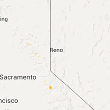
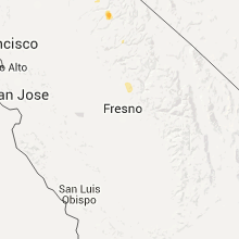
| Arnold, CA | 3 | 1.75 | 1.75 | 0 | $164k | $44.6k | 54.5 |
| Mounds, OK | 1 | 1.75 | 1.75 | 56 | $74k | $38.1k | 39.1 |
Hail and Wind Damage Spotted on 7/20/2015
Filter by Report Type:Hail ReportsWind Reports
States Impacted
New Hampshire, Florida, Connecticut, Tennessee, New York, Oklahoma, North Carolina, Alabama, California, Missouri, Georgia, New Mexico, South Carolina, Kansas, Arkansas, KentuckyNew Hampshire
| Local Time | Report Details |
|---|---|
| 10:50 AM EDT | Spotter reported trees uprooted and snappe in carroll county NH, 37.9 miles W of Portland, ME |
Florida
| Local Time | Report Details |
|---|---|
| 2:35 PM EDT | Broadcast media relayed a report of a tree down on a power line in high spring in alachua county FL, 66.3 miles WSW of Jacksonville, FL |
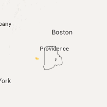
Connecticut
| Local Time | Report Details |
|---|---|
| 3:00 PM EDT | Multiple trees and wires down on babock hill road in new london county CT, 44.3 miles WSW of Providence, RI |
| 3:04 PM EDT | Multiple trees and wires down on babock hill road in new london county CT, 42 miles WSW of Providence, RI |
| 3:20 PM EDT | Trees and wires down at 5 lincoln square in new london county CT, 32.9 miles WSW of Providence, RI |
| 3:20 PM EDT | Trees and wires down on pinecrest lane in new london county CT, 37.3 miles WSW of Providence, RI |
| 3:20 PM EDT | Tree down at intersection of north burnham highway rt 169 and lisbon heights in new london county CT, 34.6 miles WSW of Providence, RI |
| 3:25 PM EDT | Trees and wires down at intersection of tyler terrace and roode road in new london county CT, 32.3 miles WSW of Providence, RI |
Tennessee
| Local Time | Report Details |
|---|---|
| 2:00 PM CDT | Power line reportedly blown down in hickman county TN, 45.8 miles SW of Nashville, TN |
| 5:40 PM EDT | Several trees downed across northern part of blount count in blount county TN, 15.1 miles SW of Knoxville, TN |
New York
| Local Time | Report Details |
|---|---|
| 4:50 PM EDT | Large tree and branches down at bethpage-sweethollow road in nassau county NY, 28.7 miles E of Brooklyn, NY |
Oklahoma
| Local Time | Report Details |
|---|---|
| 4:00 PM CDT | Time estimated from rada in canadian county OK, 39.8 miles WNW of Oklahoma City, OK |
| 4:20 PM CDT | Power poles downed by strong wind in wagoner county OK, 18.3 miles ESE of Tulsa, OK |
| 4:25 PM CDT | Tree damage at 288th and 71s in wagoner county OK, 19.6 miles ESE of Tulsa, OK |
| 4:40 PM CDT | Trees down near the armed forces reserve cente in wagoner county OK, 19.2 miles ESE of Tulsa, OK |
| 5:08 PM CDT | Golf Ball sized hail reported near Mounds, OK, 16.6 miles S of Tulsa, OK, report via social media pictures of hail. |
| 5:15 PM CDT | Large trees down especially near the junction of highways 64 and 6 in muskogee county OK, 33 miles SSE of Tulsa, OK |
| 5:25 PM CDT | Power lines downed by strong wind in custer county OK, 67.2 miles W of Oklahoma City, OK |
| 5:25 PM CDT | Three power poles down. time estimated from rada in custer county OK, 69 miles W of Oklahoma City, OK |
| 5:45 PM CDT | Carport pulled down. time estimated from rada in custer county OK, 66.6 miles W of Oklahoma City, OK |
| 9:20 PM CDT | Quarter sized hail reported near Yukon, OK, 12.5 miles W of Oklahoma City, OK |
North Carolina
| Local Time | Report Details |
|---|---|
| 5:40 PM EDT | Several trees down near granada golf course to the east of highway 321 near falls avenu in caldwell county NC, 50.9 miles NW of Charlotte, NC |
| 7:08 PM EDT | A report of trees and power lines down along river hill road. time is estimated based on when the radar max velocity of 26 knots passed over that locatio in iredell county NC, 41.2 miles N of Charlotte, NC |
| 8:02 PM EDT | Tree in roadway on hambright road to the southwest of huntersville. a tree down on power lines at intersection of north main and fourth street. time based on radar velo in mecklenburg county NC, 13 miles N of Charlotte, NC |
| 8:03 PM EDT | A tree in the roadwa in cabarrus county NC, 23.9 miles ENE of Charlotte, NC |
| 9:12 PM EDT | Trees down at butler road and hazelwood drive near highway 74 in forest cit in rutherford county NC, 54.3 miles NE of Greenville, SC |
| 9:16 PM EDT | Tree down across power lines on carol ave in locust in stanly county NC, 23.9 miles E of Charlotte, NC |
Alabama
| Local Time | Report Details |
|---|---|
| 4:47 PM CDT | Tree down on cedar springs road in houston county AL, 79 miles NW of Tallahassee, FL |
California
| Local Time | Report Details |
|---|---|
| 3:50 PM PDT | Golf Ball sized hail reported near Arnold, CA, 68.1 miles E of Citrus Heights, CA, 1 mile sw of bear valley at hells kitchen |
| 3:50 PM PDT | Golf Ball sized hail reported near Arnold, CA, 67.5 miles ESE of Citrus Heights, CA, golf ball size hail at hells kitchen vista. |
| 4:05 PM PDT | Golf Ball sized hail reported near Arnold, CA, 68.5 miles E of Citrus Heights, CA, bear valley. |
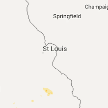
Missouri
| Local Time | Report Details |
|---|---|
| 5:53 PM CDT | Missouri highway patrol reported a tree down near cape fair. time estimated by rada in stone county MO, 35.2 miles SSW of Springfield, MO |
| 6:16 PM CDT | Emergency management reported a tree down on highway dd se of kimberling city. time estimated by rada in stone county MO, 43 miles S of Springfield, MO |
| 7:20 PM CDT | Tree down. bb hw in howell county MO, 63.4 miles SSW of Salem, MO |
| 7:40 PM CDT | Law enforcement reported a tree down near thomasville. time estimated by rada in oregon county MO, 58.4 miles S of Salem, MO |
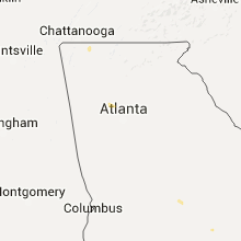
Georgia
| Local Time | Report Details |
|---|---|
| 6:58 PM EDT | Tree down on westover road near westgate in dougherty county GA, 80 miles N of Tallahassee, FL |
| 7:03 PM EDT | Main power line down on murray hill lane in albany. per wfxl meteorologis in dougherty county GA, 79.9 miles W of Douglas, GA |
| 7:08 PM EDT | Quarter sized hail reported near Albany, GA, 78.8 miles W of Douglas, GA, photo of quarter size hail submitted on social media |
| 7:10 PM EDT | Tree snapped on cascade lane. photo submitted on social medi in dougherty county GA, 80 miles W of Douglas, GA |
| 7:12 PM EDT | Wires down on the 700 block of north jackson street in albany...per wfxl meteorologis in dougherty county GA, 76.9 miles W of Douglas, GA |
| 7:12 PM EDT | Downed tree on a power line eventually caught fire on the 400 block of w lincoln avenue in albany. per wfxl meteorologis in dougherty county GA, 77.5 miles W of Douglas, GA |
| 7:15 PM EDT | Several trees and power lines down around town in dougherty county GA, 78.7 miles W of Douglas, GA |
| 7:18 PM EDT | Police blocking traffic at n carroll street and east 1st ave due to power line down in dougherty county GA, 75.2 miles W of Douglas, GA |
| 8:10 PM EDT | Wrdw-tv relayed social media report from the public of a tree down on a home in national hill in richmond county GA, 3.3 miles NW of Augusta, GA |
New Mexico
| Local Time | Report Details |
|---|---|
| 5:45 PM MDT | A bnsf train partially derailed in strong winds near fort sumner. several large rail cars were blown off the track in de baca county NM, 56.4 miles SSW of Tucumcari, NM |
South Carolina
| Local Time | Report Details |
|---|---|
| 8:40 PM EDT | Pickesn sheriff office reports many trees and a few power lines down in the dacusville and easley area in pickens county SC, 7.9 miles NNE of Greenville, SC |
| 8:40 PM EDT | Multiple trees down and a shed blown over... foster blackmon dr and fork hill r in lancaster county SC, 40.7 miles SSE of Charlotte, NC |
| 8:50 PM EDT | Aiken 911 reported tree down... taking down a power line... causing a small brush fir in aiken county SC, 17 miles ESE of Augusta, GA |
| 9:15 PM EDT | Schp reports trees down at williston way and deering r in barnwell county SC, 33.9 miles ESE of Augusta, GA |
| 9:50 PM EDT | Schp reports trees down on us hwy 78 and mt. zion rd... between blackville and denmar in bamberg county SC, 45.1 miles E of Augusta, GA |
| 9:55 PM EDT | Schp reports trees down on hwy 70 at the edisto rive in orangeburg county SC, 52.2 miles E of Augusta, GA |
| 9:55 PM EDT | Schp reports trees down on cordova rd and wesley grove r in orangeburg county SC, 54.2 miles WNW of Charleston, SC |
Kansas
| Local Time | Report Details |
|---|---|
| 8:20 PM CDT | Quarter sized hail reported near Canton, KS, 40.3 miles N of Wichita, KS |
Arkansas
| Local Time | Report Details |
|---|---|
| 8:25 PM CDT | Powerlines down in sale in fulton county AR, 88.8 miles S of Salem, MO |
| 9:30 PM CDT | Measured wind gust of 58 mph from handheld anemometer near intersection of cr 611 and 62 in greene county AR, 67.9 miles NNW of Memphis, TN |
Kentucky
| Local Time | Report Details |
|---|---|
| 11:00 PM CDT | Late report. donwed trees and powerlines in the community with spotty power outage in muhlenberg county KY, 56.9 miles SSE of Evansville, IN |
| 11:05 PM CDT | Trees dow in ohio county KY, 54.2 miles SE of Evansville, IN |
| 11:05 PM CDT | Trees down blocking roa in ohio county KY, 51.8 miles SE of Evansville, IN |
| 4:35 AM EDT | Trees were blown down near canad in pike county KY, 63.5 miles SW of Charleston, WV |
| 4:35 AM EDT | Trees were blown down near sidne in pike county KY, 63.6 miles SW of Charleston, WV |
Connect with Interactive Hail Maps