

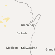
Hail Map for Wednesday, July 20, 2016

Number of Impacted Households on 7/20/2016
0
Impacted by 1" or Larger Hail
0
Impacted by 1.75" or Larger Hail
0
Impacted by 2.5" or Larger Hail
Square Miles of Populated Area Impacted on 7/20/2016
0
Impacted by 1" or Larger Hail
0
Impacted by 1.75" or Larger Hail
0
Impacted by 2.5" or Larger Hail


Cities Most Affected by Hail Storms of 7/20/2016
| Hail Size | Demographics of Zip Codes Affected | ||||||
|---|---|---|---|---|---|---|---|
| City | Count | Average | Largest | Pop Density | House Value | Income | Age |
| Mcclusky, ND | 2 | 2.50 | 2.50 | 1 | $22k | $21.3k | 54.7 |
| Berthold, ND | 2 | 2.25 | 2.75 | 2 | $65k | $29.5k | 39.7 |
| Bison, SD | 1 | 1.75 | 1.75 | 0 | $35k | $28.6k | 46.8 |
| Clear Lake, WI | 1 | 1.75 | 1.75 | 36 | $88k | $42.3k | 39.8 |
| Downing, WI | 1 | 1.75 | 1.75 | 27 | $75k | $42.1k | 43.4 |
Hail and Wind Damage Spotted on 7/20/2016
Filter by Report Type:Hail ReportsWind Reports
States Impacted
Wisconsin, Mississippi, Tennessee, Kentucky, South Carolina, Georgia, South Dakota, North Dakota, North Carolina, Minnesota, MichiganWisconsin
| Local Time | Report Details |
|---|---|
| 10:05 AM CDT | Half Dollar sized hail reported near Comstock, WI, 67.8 miles ENE of Minneapolis, MN, half dollar sized hail was reported via facebook in comstock. . |
| 10:45 AM CDT | Golf Ball sized hail reported near Clear Lake, WI, 58 miles ENE of Minneapolis, MN, county sheriff reported golfball sized hail in new haven township. . |
| 10:45 AM CDT | County sheriff reported trees down in new haven townshi in dunn county WI, 58 miles ENE of Minneapolis, MN |
| 11:00 AM CDT | Golf Ball sized hail reported near Downing, WI, 57.9 miles ENE of Minneapolis, MN, county sheriff reported that golfball sized had been falling for 15 minutes /as of 11 am/ in new haven township. . |
| 4:29 AM CDT | Storm damage reported in ashland county WI, 58.5 miles ESE of Duluth, MN |
| 4:58 AM CDT | Tree down on roa in barron county WI, 80.3 miles ENE of Minneapolis, MN |
| 5:08 AM CDT | Trees/branches down in town as well as on hwy ss 1 mile e of town. in barron county WI, 82.6 miles ENE of Minneapolis, MN |
| 6:19 AM CDT | Tree blown down in the city of medford. a few other trees reported down across the county. time estimated using radar. in taylor county WI, 56.8 miles SW of Rhinelander, WI |
Mississippi
| Local Time | Report Details |
|---|---|
| 1:12 PM CDT | A few trees were knocked down near taylorsvill in smith county MS, 54 miles SE of Jackson, MS |
Tennessee
| Local Time | Report Details |
|---|---|
| 2:25 PM CDT | Storm damage reported in shelby county TN, 7.8 miles SE of Memphis, TN |
| 2:45 PM CDT | Powerlines down at walnut grove road and cherry lane. time is radar estimate in shelby county TN, 10.8 miles E of Memphis, TN |
Kentucky
| Local Time | Report Details |
|---|---|
| 2:45 PM CDT | Power lines down on industrial road in murray in calloway county KY, 35.1 miles NNE of Mc Kenzie, TN |
South Carolina
| Local Time | Report Details |
|---|---|
| 3:53 PM EDT | Tree down and blocking road on overlook lane. caused by otuflow boundary from thunderstorm in colleton county SC, 47.4 miles WSW of Charleston, SC |
| 4:09 PM EDT | Trained spotter reported trees down at a business along confederate highway. time was estimated from radar dat in colleton county SC, 57.3 miles WSW of Charleston, SC |
| 4:12 PM EDT | Beaufort county 911 center reported a tree down at the intersection of lands end road and storyteller road on st helena island. time was estimated from radar dat in beaufort county SC, 34.2 miles ENE of Savannah, GA |
| 4:30 PM EDT | Tree down new hopewell rd and east old camden r in darlington county SC, 73.5 miles SE of Charlotte, NC |
| 5:13 PM EDT | Several trees down in the southern portion of the savannah river site (srs)... south of l lake and hwy 125. reported by srs eoc. time estimated based on radar. in barnwell county SC, 28.9 miles SE of Augusta, GA |
| 5:15 PM EDT | Tree knocked down due to outflo in jasper county SC, 34.4 miles N of Savannah, GA |
| 5:40 PM EDT | Tree down at the intersection of route 321 and tarboro road in jasper county SC, 31.1 miles N of Savannah, GA |
| 6:04 PM EDT | Tree on powerlines off troy valley r in oconee county SC, 31.4 miles W of Greenville, SC |
| 6:27 PM EDT | Multiple trees down nw of mountain rest... s in oconee county SC, 32.5 miles W of Greenville, SC |
| 9:08 PM EDT | Trees down off rainbow lake r in spartanburg county SC, 40.2 miles ENE of Greenville, SC |
Georgia
| Local Time | Report Details |
|---|---|
| 3:55 PM EDT | Emergency management reported several trees down in the southern portion of the county.trees down on jeffery turner rd...homesville rd and highlands rd. baxley weather in appling county GA, 36 miles ENE of Douglas, GA |
| 4:25 PM EDT | Tree knocked down on a hous in chatham county GA, 3.3 miles SSE of Savannah, GA |
| 4:26 PM EDT | Trees and power lines dow in chatham county GA, 2.2 miles SSW of Savannah, GA |
| 4:50 PM EDT | Liberty county 911 center reported a tree down on the 500 block of island drive. time was estimated from radar dat in liberty county GA, 24.3 miles SW of Savannah, GA |
| 4:52 PM EDT | Ping Pong Ball sized hail reported near Midway, GA, 27.3 miles SW of Savannah, GA, tv media relayed report of 1.5 inch hail near midway ga. |
| 5:13 PM EDT | Quarter sized hail reported near Midway, GA, 25 miles SW of Savannah, GA, trained spotter reported quarter sized hail on limreck road. time was estimated from radar data. |
| 5:15 PM EDT | Liberty county 911 center reported a tree down at the intersection of beasleyville and freedman roads. time was estimated from radar dat in liberty county GA, 25.1 miles SW of Savannah, GA |
| 5:38 PM EDT | Liberty county 911 center reported a tree down in the 5200 block of highway 196. time was estimated from radar dat in liberty county GA, 30.6 miles SW of Savannah, GA |
| 5:51 PM EDT | Effingham county emergency manager relayed a report of a tree down on a car on hadden lake road. time was estimated from radar dat in effingham county GA, 25.7 miles NNW of Savannah, GA |
| 5:55 PM EDT | Effingham county emergency manager relayed a report of a tree down in the 2200 block of stillwell clyo road. time was estimated from radar dat in effingham county GA, 25.6 miles NNW of Savannah, GA |
| 6:03 PM EDT | Effingham county emergency manager relayed a report of trees on a house in the 2800 block of highway 119. time was estimated from radar dat in effingham county GA, 25.2 miles NNW of Savannah, GA |
| 6:04 PM EDT | Tree down near the intersection of calf pen bay road and laurel tree roa in effingham county GA, 26.9 miles NNW of Savannah, GA |
| 6:06 PM EDT | Tree down blocking stillwell clyo road near the intersection of berryville road in effingham county GA, 25.8 miles NNW of Savannah, GA |
| 6:08 PM EDT | Tree down across power lines on ebenezer road. time estimated based on rada in effingham county GA, 19.9 miles NNW of Savannah, GA |
| 6:11 PM EDT | Tree down across power lines on millpond road. time estimated based on rada in effingham county GA, 19.6 miles NNW of Savannah, GA |
| 6:40 PM EDT | Report of a 6-8 inch diameter tree down and several large tree branches down on cleary road off mud road. also reported a roof blown off a porch...a small tree that fel in bulloch county GA, 35.8 miles WNW of Savannah, GA |
| 7:35 PM EDT | Metter fire department relayed a report of two trees down on highway 121 near the pond view road intersection. time was estimated from radar dat in candler county GA, 62.2 miles WNW of Savannah, GA |
| 8:44 PM EDT | One tree down on gilhardin industrial blv in lowndes county GA, 54.9 miles SSW of Douglas, GA |
| 8:44 PM EDT | One power line down along bernice driv in lowndes county GA, 54.3 miles SSW of Douglas, GA |
| 8:45 PM EDT | One power line down at the 2300 block of indian ford roa in lowndes county GA, 56.3 miles SSW of Douglas, GA |
| 8:46 PM EDT | One tree down along clyattville roa in lowndes county GA, 58.2 miles SSW of Douglas, GA |
South Dakota
| Local Time | Report Details |
|---|---|
| 3:15 PM MDT | Ping Pong Ball sized hail reported near Reva, SD, 101.7 miles N of Rapid City, SD, lasted 10 minutes |
| 3:53 PM MDT | Ping Pong Ball sized hail reported near Prairie City, SD, 102.3 miles NNE of Rapid City, SD |
| 3:55 PM MDT | Quarter sized hail reported near Prairie City, SD, 102.3 miles NNE of Rapid City, SD |
| 4:40 PM MDT | Quarter sized hail reported near Lemmon, SD, 104.1 miles SW of Bismarck, ND |
| 4:46 PM MDT | Golf Ball sized hail reported near Bison, SD, 102.4 miles NNE of Rapid City, SD |
| 6:00 PM MDT | Quarter sized hail reported near Rapid City, SD, 8.5 miles S of Rapid City, SD |
| 6:00 PM MDT | Storm damage reported in pennington county SD, 8.5 miles S of Rapid City, SD |
North Dakota
| Local Time | Report Details |
|---|---|
| 5:02 PM CDT | Golf Ball sized hail reported near Berthold, ND, 30.3 miles WNW of Minot, ND, hail ongoing. |
| 5:23 PM CDT | Baseball sized hail reported near Berthold, ND, 21.1 miles WNW of Minot, ND |
| 5:34 PM CDT | Quarter sized hail reported near Burlington, ND, 8.4 miles WNW of Minot, ND, ongoing at the time of call |
| 5:52 PM MDT | Quarter sized hail reported near New Leipzig, ND, 64.7 miles WSW of Bismarck, ND, hail ongoing at the time of call. |
| 6:10 PM MDT | Half Dollar sized hail reported near Elgin, ND, 58.2 miles WSW of Bismarck, ND, on the north side of elgin. social media post. |
| 7:20 PM CDT | Quarter sized hail reported near Drake, ND, 43.4 miles ESE of Minot, ND |
| 6:29 PM MDT | Quarter sized hail reported near New Leipzig, ND, 63.4 miles WSW of Bismarck, ND, ongoing at the time of call |
| 7:50 PM CDT | Quarter sized hail reported near Hazen, ND, 46.3 miles WNW of Bismarck, ND, arb observer |
| 8:10 PM CDT | Quarter sized hail reported near Rocklake, ND, 52.1 miles NNW of Devils Lake, ND |
| 8:15 PM CDT | Trees uprooted. power outage in benson county ND, 45 miles W of Devils Lake, ND |
| 8:15 PM CDT | Peak wind measured by the ndawn senso in benson county ND, 37 miles W of Devils Lake, ND |
| 8:33 PM CDT | Storm damage reported in benson county ND, 29.6 miles WNW of Devils Lake, ND |
| 7:35 PM MDT | Quarter sized hail reported near Stanton, ND, 39.6 miles NW of Bismarck, ND, arb observer |
| 8:37 PM CDT | Quarter sized hail reported near Harvey, ND, 50.9 miles W of Devils Lake, ND, hailing at the time of call |
| 8:59 PM CDT | Quarter sized hail reported near Center, ND, 32.9 miles NW of Bismarck, ND |
| 9:10 PM CDT | Half Dollar sized hail reported near Center, ND, 32.9 miles NW of Bismarck, ND, social media post. north side of center. |
| 9:23 PM CDT | Half Dollar sized hail reported near Center, ND, 32.9 miles NW of Bismarck, ND, emailed a picture |
| 9:25 PM CDT | Quarter sized hail reported near Mcclusky, ND, 55.2 miles NNE of Bismarck, ND |
| 9:32 PM CDT | Tennis Ball sized hail reported near Mcclusky, ND, 49.9 miles NNE of Bismarck, ND |
| 9:32 PM CDT | Tennis Ball sized hail reported near Mcclusky, ND, 54.3 miles NNE of Bismarck, ND |
| 10:40 PM CDT | Carrington airport awos observatio in foster county ND, 47.7 miles SSW of Devils Lake, ND |
| 11:41 PM CDT | Peak wind measured at a personal weather station. commercial power is out in that are in steele county ND, 58.9 miles NW of Fargo, ND |
| 12:03 AM CDT | Peak wind of 60 knots measured at the fargo airport /kfar in cass county ND, 4.1 miles NW of Fargo, ND |
| 12:10 AM CDT | Tin roof damage in cass county ND, 9.8 miles SW of Fargo, ND |
North Carolina
| Local Time | Report Details |
|---|---|
| 6:59 PM EDT | Trees and powerlines down in mcdowell county NC, 66 miles SSE of Bristol, TN |
| 7:00 PM EDT | A few trees down in mcdowell county NC, 66.4 miles SSE of Bristol, TN |
Minnesota
| Local Time | Report Details |
|---|---|
| 8:15 PM CDT | Peak wind measured by the ndawn senso in clay county MN, 14.2 miles SE of Fargo, ND |
| 9:34 PM CDT | Storm damage reported in kittson county MN, 53.7 miles W of Roseau, MN |
| 10:55 PM CDT | Peak winds measured at a persoanl weather statio in polk county MN, 72.8 miles SW of Roseau, MN |
| 12:05 AM CDT | Two box elder trees downed. the larger tree was approximately 2 feet in diamete in norman county MN, 48.8 miles NE of Fargo, ND |
| 12:11 AM CDT | Peak winds measured at the rwis along hwy 5 in mahnomen county MN, 46.6 miles NE of Fargo, ND |
| 12:35 AM CDT | Peak winds measured at the detroit lakes airport /kdtl in becker county MN, 41.6 miles E of Fargo, ND |
| 12:44 AM CDT | Large tree branches and limbs broken down around tow in becker county MN, 45.4 miles E of Fargo, ND |
| 12:50 AM CDT | Two tree reported snapped in a yar in clearwater county MN, 19.9 miles SW of Bemidji, MN |
| 12:51 AM CDT | Few trees down on county road 31 in big falls and on highway 6. time estimated by rada in koochiching county MN, 34.1 miles SSW of International Falls, MN |
| 12:58 AM CDT | Mature trees broken down in wilton. power lines down as wel in beltrami county MN, 5.8 miles WNW of Bemidji, MN |
| 1:02 AM CDT | Large tree branches and limbs broken down around camp wilderness. power outage reporte in hubbard county MN, 26.5 miles S of Bemidji, MN |
| 1:05 AM CDT | Peak winds measured at the bemidji airport /kbji in beltrami county MN, 3.4 miles WNW of Bemidji, MN |
| 1:13 AM CDT | Numerous large trees broken down around town. roofing blown off building in beltrami county MN, 0.5 miles N of Bemidji, MN |
| 1:20 AM CDT | Numerous large trees broken down around town. roofing blown off building in beltrami county MN, 0.5 miles N of Bemidji, MN |
| 1:25 AM CDT | Peak winds measured at a personal weather statio in otter tail county MN, 43 miles ESE of Fargo, ND |
| 1:35 AM CDT | 18 to 24 inch diameter tree downed. time estimated by rada in cass county MN, 56.7 miles SSE of Bemidji, MN |
| 1:45 AM CDT | Numerous large trees down along highway in crow wing county MN, 59.9 miles SSE of Bemidji, MN |
| 1:45 AM CDT | Multiple trees reported down. time estimated by rada in crow wing county MN, 65.8 miles SSE of Bemidji, MN |
| 1:48 AM CDT | Multiple trees reported down. time estimated by rada in crow wing county MN, 72.6 miles SSE of Bemidji, MN |
| 1:55 AM CDT | Storm damage reported in itasca county MN, 38.5 miles E of Bemidji, MN |
| 1:55 AM CDT | Storm damage reported in cass county MN, 35.2 miles E of Bemidji, MN |
| 2:01 AM CDT | Cass lake raws in cass county MN, 14.2 miles ESE of Bemidji, MN |
| 2:02 AM CDT | 12 inch diameter tree broke at ground and partially uprooted. several other smaller trees snapped off higher up. time estimated by rada in cass county MN, 54.2 miles ESE of Bemidji, MN |
| 2:03 AM CDT | Time estimated by rada in crow wing county MN, 84.2 miles SSE of Bemidji, MN |
| 2:24 AM CDT | Large tree branches up to 10 inches in diameter downed in the northeast side of grand rapids. time estimated by rada in itasca county MN, 66 miles ESE of Bemidji, MN |
| 2:54 AM CDT | Many trees down including some uprooted. time estimated from rada in st. louis county MN, 38.4 miles WNW of Duluth, MN |
| 3:05 AM CDT | Larger than 10 inch diameter popple tree downed with power lines wrapped in it along the west side of aerie lake. many 8 to 10 inch diameter popple trees downed along h in st. louis county MN, 28.7 miles WNW of Duluth, MN |
| 3:07 AM CDT | Raws station hcym in aitkin county MN, 69.9 miles ESE of Bemidji, MN |
| 3:10 AM CDT | Lots of large trees down along highway 53 south of canyon. time estimated by rada in st. louis county MN, 24.2 miles NW of Duluth, MN |
| 3:13 AM CDT | Storm damage reported in lake county MN, 85.1 miles NNE of Duluth, MN |
| 3:20 AM CDT | 10 inch birch down on northwest side of caribou lake on birch point road. numerous other trees down. 24 to 30 inch diameter spruce tree snapped feet 15 above the grov in st. louis county MN, 13.8 miles NW of Duluth, MN |
| 3:23 AM CDT | Powerline down at the corner of highway 53 and ugstad road. numerous trees and large branches down near this location. time estimated by rada in st. louis county MN, 7.6 miles WNW of Duluth, MN |
| 3:25 AM CDT | 2 large birch trees snapped off. power is ou in st. louis county MN, 3.6 miles NW of Duluth, MN |
| 3:30 AM CDT | Mndot road weather station at i-35 thompson hill mm24 in st. louis county MN, 8.5 miles WSW of Duluth, MN |
| 3:32 AM CDT | Numerous trees down in lakeside on london road. time estimated by rada in st. louis county MN, 4.9 miles NE of Duluth, MN |
| 3:32 AM CDT | Storm damage reported in st. louis county MN, 5.2 miles NW of Duluth, MN |
| 3:35 AM CDT | 90 foot tall tree across 52nd ave east. time estimated from rada in st. louis county MN, 5.2 miles NE of Duluth, MN |
| 3:36 AM CDT | /site dulm5./ in st. louis county MN, 0.7 miles SE of Duluth, MN |
| 3:53 AM CDT | Sky harbor airpot awo in st. louis county MN, 4.7 miles SSE of Duluth, MN |
| 6:10 AM CDT | Quarter sized hail reported near Little Falls, MN, 87.2 miles NW of Minneapolis, MN, . |
Michigan
| Local Time | Report Details |
|---|---|
| 5:51 AM EDT | Several trees down along lake rd near little girls poin in gogebic county MI, 80.3 miles NW of Rhinelander, WI |
| 5:16 AM CDT | Trees and powerlines down in wakefiel in gogebic county MI, 63.4 miles NNW of Rhinelander, WI |
| 6:35 AM EDT | Trees dow in ontonagon county MI, 85.2 miles N of Rhinelander, WI |
| 6:52 AM EDT | Numerous trees down in and around mass cit in ontonagon county MI, 79.8 miles NNE of Rhinelander, WI |
| 7:04 AM EDT | Storm damage reported in houghton county MI, 78.3 miles WNW of Marquette, MI |
| 7:05 AM EDT | Widespread tree damage around toivala... donken... and twin lakes. m26 is blocked by fallen tree in houghton county MI, 71.6 miles WNW of Marquette, MI |
| 7:15 AM EDT | Numerous trees down across baraga county. tree blocking us 41 south of lans in baraga county MI, 51.3 miles W of Marquette, MI |
| 6:25 AM CDT | Trees dow in iron county MI, 47.3 miles NE of Rhinelander, WI |
| 6:30 AM CDT | Several trees reported dow in iron county MI, 49 miles NE of Rhinelander, WI |
Connect with Interactive Hail Maps