

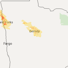
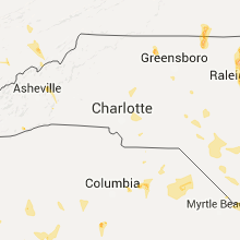
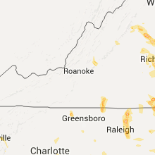
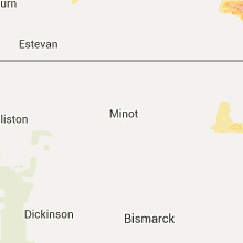
Hail Map for Tuesday, July 19, 2016

Number of Impacted Households on 7/19/2016
0
Impacted by 1" or Larger Hail
0
Impacted by 1.75" or Larger Hail
0
Impacted by 2.5" or Larger Hail
Square Miles of Populated Area Impacted on 7/19/2016
0
Impacted by 1" or Larger Hail
0
Impacted by 1.75" or Larger Hail
0
Impacted by 2.5" or Larger Hail


Cities Most Affected by Hail Storms of 7/19/2016
| Hail Size | Demographics of Zip Codes Affected | ||||||
|---|---|---|---|---|---|---|---|
| City | Count | Average | Largest | Pop Density | House Value | Income | Age |
| Grafton, ND | 1 | 4.00 | 4.00 | 22 | $60k | $36.0k | 43.0 |
| Crystal, ND | 1 | 3.00 | 3.00 | 2 | $48k | $32.7k | 47.1 |
| Walhalla, ND | 1 | 2.50 | 2.50 | 4 | $50k | $32.2k | 48.1 |
| Waverly, VA | 1 | 2.00 | 2.00 | 17 | $73k | $32.5k | 44.5 |
| Haywood, VA | 1 | 1.75 | 1.75 | 69 | $120k | $26.0k | 43.3 |
| Ringgold, VA | 1 | 1.75 | 1.75 | 105 | $82k | $37.6k | 42.0 |
| Jonesborough, TN | 1 | 1.75 | 1.75 | 219 | $97k | $36.1k | 41.1 |
| Youngsville, NC | 1 | 1.75 | 1.75 | 275 | $118k | $50.1k | 38.0 |
| Springfield, SC | 1 | 1.75 | 1.75 | 16 | $54k | $27.2k | 44.1 |
Hail and Wind Damage Spotted on 7/19/2016
Filter by Report Type:Hail ReportsWind Reports
States Impacted
North Carolina, Iowa, Virginia, North Dakota, Illinois, Tennessee, South Carolina, Georgia, Wyoming, Alabama, Missouri, Florida, Colorado, Montana, Minnesota, Idaho, Maryland, District of Columbia, New Mexico, DelawareNorth Carolina
| Local Time | Report Details |
|---|---|
| 8:46 AM EDT | Report of tree down in ponzer area in hyde county NC, 83.9 miles SSW of Virginia Beach, VA |
| 11:50 AM EDT | Storm damage reported in onslow county NC, 47.4 miles NE of Wilmington, NC |
| 12:04 PM EDT | Spotter reports tree on vehicle at rosemont ave and south main s in cabarrus county NC, 22.2 miles NNE of Charlotte, NC |
| 12:10 PM EDT | Trees blown down and blocking morgan mill rd near deese r in union county NC, 23.2 miles SE of Charlotte, NC |
| 12:12 PM EDT | A couple trees blown down on lanier l in union county NC, 23.2 miles SE of Charlotte, NC |
| 1:30 PM EDT | Tree down on adams creek rd. in havelock in craven county NC, 86.3 miles ENE of Wilmington, NC |
| 2:12 PM EDT | Quarter sized hail reported near Wilmington, NC, 6.9 miles ENE of Wilmington, NC, intersection of gordon rd and market st. |
| 3:49 PM EDT | Quarter sized hail reported near Grifton, NC, 75.1 miles ESE of Raleigh, NC, public reported dime to quarter size hail near quinerly crossroads east of grifton. |
| 4:01 PM EDT | Tree down across the road at the intersection of wintergreen and loop rd. in cove cit in craven county NC, 77.2 miles NNE of Wilmington, NC |
| 5:15 PM EDT | Trees and power lines down on mill creek road near the intersection with graphite road. time determined from radar dat in mcdowell county NC, 59.8 miles NNE of Greenville, SC |
| 5:35 PM EDT | Onslow county 911 reported a tree down across piney green road. time based on rada in onslow county NC, 50.4 miles NE of Wilmington, NC |
| 6:35 PM EDT | Thunderstorm winds resulted in at least two trees down temporarily cloising roads between danbury and germanton n in stokes county NC, 67.3 miles SSW of Roanoke, VA |
| 6:35 PM EDT | Thunderstorm winds resulted in several trees down within the community of meadows in stokes county... n in stokes county NC, 63.6 miles SSW of Roanoke, VA |
| 6:44 PM EDT | Thunderstorm winds resulted in at least two trees down temporarily cloising roads between danbury and germanton n in stokes county NC, 66.2 miles S of Roanoke, VA |
| 6:48 PM EDT | Thunderstorm winds resulted in numerous trees down within the community of walnut cov in stokes county NC, 68.6 miles S of Roanoke, VA |
| 7:44 PM EDT | Thunderstorm winds downed two trees along country club roa in yadkin county NC, 66.1 miles N of Charlotte, NC |
| 9:12 PM EDT | Several trees down... some on powerlines. time estimated by rada in vance county NC, 37 miles NNE of Raleigh, NC |
| 9:30 PM EDT | Large pine tree down on eastwood terrac in robeson county NC, 64.7 miles WNW of Wilmington, NC |
| 9:45 PM EDT | Structural damage on tp rd in robeson county NC, 62.1 miles WNW of Wilmington, NC |
| 9:47 PM EDT | Trees blown down across powerlines at the intersection of mooresville rd and round tuit l in rowan county NC, 30.5 miles NNE of Charlotte, NC |
| 9:47 PM EDT | Power lines knocked down across mooresville rd. moorseville rd has been close in rowan county NC, 31.5 miles NNE of Charlotte, NC |
| 9:48 PM EDT | Trees knocked down blocking fannie sloan rd near mooresville rd...road closed. power pole snapped in hal in rowan county NC, 30.5 miles NNE of Charlotte, NC |
| 9:48 PM EDT | Trees blown down blocking fannie sloan rd near millbridge rd. roadway is close in rowan county NC, 30.9 miles NNE of Charlotte, NC |
| 9:50 PM EDT | Tree down. time estimated by rada in hoke county NC, 64.1 miles SSW of Raleigh, NC |
| 9:55 PM EDT | Tree down on powerlines. time estimated by rada in hoke county NC, 66.7 miles SSW of Raleigh, NC |
| 10:00 PM EDT | Golf Ball sized hail reported near Youngsville, NC, 19.4 miles NNE of Raleigh, NC, . |
| 10:01 PM EDT | A tree and powerlines down on a residence. time estimated by rada in franklin county NC, 20 miles NNE of Raleigh, NC |
| 10:35 PM EDT | Tree down. time estimated by rada in wake county NC, 9.3 miles E of Raleigh, NC |
| 10:52 PM EDT | Tree blown down blocking rocky river road near lower rocky river r in cabarrus county NC, 14.7 miles ENE of Charlotte, NC |
| 11:08 PM EDT | Multiple reports of trees and power lines knocked down along hickory ridge rd and around morrison r in cabarrus county NC, 12.9 miles ENE of Charlotte, NC |
| 11:09 PM EDT | Fire dept reports three trees and power lines blown down on pharr mill r in cabarrus county NC, 14.5 miles ENE of Charlotte, NC |
| 11:42 PM EDT | Spotter reports trees blown down blocking roadway at mt olivet rd and cemetary s in cabarrus county NC, 20.3 miles NE of Charlotte, NC |
| 11:44 PM EDT | Section of siding was blown off house. penny size hai in cabarrus county NC, 19.1 miles E of Charlotte, NC |
| 11:45 PM EDT | Trees and powerlines down along rankin stree in cabarrus county NC, 22.2 miles NNE of Charlotte, NC |
| 12:03 AM EDT | A tree was blown down on a power line which began to ar in caswell county NC, 60.9 miles NNW of Raleigh, NC |
| 12:04 AM EDT | Spotter reports tree on vehicle at rosemont ave and south main s in cabarrus county NC, 22.2 miles NNE of Charlotte, NC |
| 12:10 AM EDT | Trees blown down and blocking morgan mill rd near deese r in union county NC, 23.2 miles SE of Charlotte, NC |
| 12:12 AM EDT | A couple trees blown down on lanier l in union county NC, 23.2 miles SE of Charlotte, NC |
Iowa
| Local Time | Report Details |
|---|---|
| 11:26 AM CDT | Storm damage reported in shelby county IA, 40.2 miles NE of Omaha, NE |
| 11:27 AM CDT | Tree fell on car on highway 59. no injurie in shelby county IA, 42 miles NE of Omaha, NE |
| 11:29 AM CDT | Roof lifted off a bar in shelby county IA, 52.6 miles NE of Omaha, NE |
| 12:20 PM CDT | Storm damage reported in cass county IA, 58.1 miles W of Des Moines, IA |
| 2:00 PM CDT | Law enforcement reported downed trees up to 24 inches between lacona and milo. time and location estimated from radar. delayed report. in warren county IA, 29.1 miles SSE of Des Moines, IA |
| 2:20 PM CDT | Also a few small tree limbs broken off tree. wind occurred between 220 and 230 p in lucas county IA, 42.6 miles SSE of Des Moines, IA |
| 2:20 PM CDT | Apartment damaged and trees down in chariton. time estimated by rada in lucas county IA, 43.3 miles SSE of Des Moines, IA |
| 2:20 PM CDT | Trained spotter reported grain bin damage... including one rolled up against another... completely removed fence posts... and tree damage. time radar estimate in lucas county IA, 43.6 miles SE of Des Moines, IA |
| 2:20 PM CDT | Trained spotter reported damaged brick and concrete silos... barn damage... roof damage... and tree damage on farmstead. time radar estimated. in lucas county IA, 44.1 miles SE of Des Moines, IA |
| 2:35 PM CDT | Law enforcement reported trees down near 527th ave on the ne side of melrose. time estimated from radar. delayed repor in monroe county IA, 51.1 miles SE of Des Moines, IA |
| 2:37 PM CDT | 8-10 inch diameter tree limbs blown out of tree in wayne county IA, 59.3 miles SSE of Des Moines, IA |
| 2:40 PM CDT | 8-10 inch diameter tree limbs blown out of tree in wayne county IA, 62.2 miles SSE of Des Moines, IA |
| 2:43 PM CDT | Law enforcement reported trees down in mystic. time and location estimated from radar. delayed repor in appanoose county IA, 66.1 miles SSE of Des Moines, IA |
| 2:48 PM CDT | 8-10 inch diameter tree limbs blown out of tree in wayne county IA, 67.9 miles SSE of Des Moines, IA |
| 2:50 PM CDT | Law enforcement reported 12 inch diameter trees downed in centerville. time and location estimated from radar. delayed repor in appanoose county IA, 64.2 miles WNW of Kahoka, MO |
| 3:05 PM CDT | Strong wind blew law enforcement car off the roa in appanoose county IA, 64.9 miles SE of Des Moines, IA |
| 3:30 PM CDT | Storm damage reported in davis county IA, 47.8 miles WNW of Kahoka, MO |
Virginia
| Local Time | Report Details |
|---|---|
| 2:00 PM EDT | Several trees down near natural tunnel state par in scott county VA, 33.3 miles WNW of Bristol, TN |
| 2:00 PM EDT | Quarter sized hail reported near Culpeper, VA, 69 miles NNW of Richmond, VA |
| 2:05 PM EDT | Quarter sized hail reported near Culpeper, VA, 67.3 miles NNW of Richmond, VA, rt 686 and hwy 15 |
| 2:10 PM EDT | Couple trees dow in scott county VA, 30 miles WNW of Bristol, TN |
| 2:24 PM EDT | Golf Ball sized hail reported near Haywood, VA, 73 miles NNW of Richmond, VA, several trees down also |
| 2:24 PM EDT | Quarter sized hail reported near Warrenton, VA, 77 miles N of Richmond, VA |
| 2:25 PM EDT | Trees down at ridgeview road and w hoover road in madison county VA, 71.8 miles NNW of Richmond, VA |
| 2:25 PM EDT | Thunderstorm winds resulted in one tree down near the natural bridge safari par in rockbridge county VA, 36.3 miles NE of Roanoke, VA |
| 2:33 PM EDT | Trees down at 500 block of n seminole trail in madison county VA, 69.7 miles NNW of Richmond, VA |
| 2:43 PM EDT | Quarter sized hail reported near Locust Grove, VA, 55.8 miles N of Richmond, VA |
| 2:45 PM EDT | Quarter sized hail reported near Locust Grove, VA, 53.8 miles N of Richmond, VA |
| 2:52 PM EDT | Tree down on power lines near tatum rd and lawyers rd in spotsylvania county VA, 50.5 miles NNW of Richmond, VA |
| 2:55 PM EDT | About 8 trees down along ruth rd in scattered locations including near intersection of ruth rd and thrift rd in madison county VA, 70.7 miles NNW of Richmond, VA |
| 2:55 PM EDT | About 8 trees down along ruth rd in scattered locations including near intersection of ruth rd and thrift rd in madison county VA, 70.7 miles NNW of Richmond, VA |
| 2:58 PM EDT | Thunderstorm winds resulted in a tree down at the intersection of forge road and shepards ru in rockbridge county VA, 34.7 miles NE of Roanoke, VA |
| 3:02 PM EDT | Tree down near intersection of forge road and amberwoods drive in rockbridge county VA, 35.6 miles NE of Roanoke, VA |
| 3:05 PM EDT | Half Dollar sized hail reported near Glasgow, VA, 36.6 miles NE of Roanoke, VA, lasted about 2 minutes |
| 3:05 PM EDT | Thunderstorm winds resulted in a tree down within the community of glasgow... v in rockbridge county VA, 36.6 miles NE of Roanoke, VA |
| 3:22 PM EDT | Quarter sized hail reported near Spotsylvania, VA, 42.5 miles N of Richmond, VA |
| 3:38 PM EDT | Quarter sized hail reported near Big Island, VA, 36.6 miles ENE of Roanoke, VA |
| 3:55 PM EDT | Tree down on cross county rd. near i-6 in louisa county VA, 23.7 miles NNW of Richmond, VA |
| 3:55 PM EDT | Trees down along with a power line near louisa. in louisa county VA, 40.4 miles NNW of Richmond, VA |
| 3:55 PM EDT | Trees down on i-64 near oilvill in goochland county VA, 15.9 miles NNW of Richmond, VA |
| 4:15 PM EDT | Trees down along manakin rd and dogwood trail. in hanover county VA, 15.3 miles NNW of Richmond, VA |
| 4:15 PM EDT | Tree down on cross county rd. near i-6 in louisa county VA, 23.7 miles NNW of Richmond, VA |
| 4:20 PM EDT | Quarter sized hail reported near Glasgow, VA, 36.5 miles NE of Roanoke, VA |
| 4:30 PM EDT | Quarter sized hail reported near Henrico, VA, 7.7 miles NNE of Richmond, VA, . |
| 4:30 PM EDT | Half Dollar sized hail reported near Henrico, VA, 6.8 miles NNE of Richmond, VA, . |
| 4:30 PM EDT | Quarter sized hail reported near Henrico, VA, 7 miles NNE of Richmond, VA, quarter size hail at patterson and lauderdale. |
| 4:45 PM EDT | Trees down on powhite parkway near the toll in city of richmond county VA, 7.6 miles ENE of Richmond, VA |
| 4:50 PM EDT | 911 dispatch is reporting numerous trees down in the city of richmond especially across the south side. in city of richmond county VA, 10.1 miles E of Richmond, VA |
| 4:50 PM EDT | Several large limbs dow in chesterfield county VA, 6.7 miles E of Richmond, VA |
| 4:55 PM EDT | Quarter sized hail reported near Richmond, VA, 4.6 miles ENE of Richmond, VA, . |
| 4:58 PM EDT | Trees uprooted and snapped about 2 miles southeast of the university of richmond in chesterfield county VA, 6.9 miles ENE of Richmond, VA |
| 5:00 PM EDT | Large limbs dow in henrico county VA, 7.2 miles NNE of Richmond, VA |
| 5:00 PM EDT | Large limbs down. nickel size hai in city of richmond county VA, 7.3 miles E of Richmond, VA |
| 5:00 PM EDT | Tree down across labernum ave. large tree limbs and branches dow in henrico county VA, 15.1 miles E of Richmond, VA |
| 5:00 PM EDT | Trees down near chippenham pkwy north of hull st. r in city of richmond county VA, 7.3 miles E of Richmond, VA |
| 5:05 PM EDT | Tree on home in forest hill. in city of richmond county VA, 9.5 miles E of Richmond, VA |
| 5:05 PM EDT | Tree down on hom in city of richmond county VA, 7.1 miles ENE of Richmond, VA |
| 5:05 PM EDT | Trees down at britton rd and darbytown r in henrico county VA, 17.8 miles E of Richmond, VA |
| 5:09 PM EDT | Storm damage reported in henrico county VA, 18.2 miles E of Richmond, VA |
| 5:10 PM EDT | Quarter sized hail reported near Richmond, VA, 3.9 miles E of Richmond, VA, . |
| 5:20 PM EDT | Tree across southbury av in henrico county VA, 13.8 miles E of Richmond, VA |
| 5:24 PM EDT | Tree blocking new market rd. large limbs dow in henrico county VA, 14.5 miles E of Richmond, VA |
| 5:25 PM EDT | Tree down near darbytown r in henrico county VA, 15.5 miles E of Richmond, VA |
| 5:25 PM EDT | Large tree across strath rd. near kinva in henrico county VA, 16.8 miles E of Richmond, VA |
| 5:25 PM EDT | Large trees down in screamersville near enon church and central ave. large limbs caused roof damage. in chesterfield county VA, 22.6 miles SE of Richmond, VA |
| 5:30 PM EDT | Numerous trees down. 2 trees on homes. trees on power line in city of hopewell county VA, 24.3 miles SE of Richmond, VA |
| 5:30 PM EDT | Several large limbs dow in henrico county VA, 16.3 miles ESE of Richmond, VA |
| 6:00 PM EDT | Trees down along ruffin rd at sandy ridge r in city of hopewell county VA, 26.5 miles ESE of Richmond, VA |
| 6:00 PM EDT | Trees down along hines rd at webb r in prince george county VA, 31.7 miles SE of Richmond, VA |
| 6:15 PM EDT | Trees down along highway 460. road is closed. in sussex county VA, 41.1 miles SE of Richmond, VA |
| 6:20 PM EDT | Large tree branch across rt. 460 5 miles west of waverl in sussex county VA, 38.9 miles SE of Richmond, VA |
| 6:25 PM EDT | Trees down along paris rd and dry bread r in brunswick county VA, 58.2 miles S of Richmond, VA |
| 6:35 PM EDT | Hen Egg sized hail reported near Waverly, VA, 46.4 miles SE of Richmond, VA, report of a corn field stripped by large hail on beaverdam rd near harrels mille pond. |
| 6:50 PM EDT | Several trees down around ivo in southampton county VA, 47.8 miles WNW of Virginia Beach, VA |
| 7:15 PM EDT | Tree down. several branches dow in isle of wight county VA, 42.9 miles W of Virginia Beach, VA |
| 11:45 PM EDT | Golf Ball sized hail reported near Ringgold, VA, 60.8 miles SE of Roanoke, VA, hail up to golf ball size reported in sutherlin |
| 12:44 AM EDT | Quarter sized hail reported near Arlington, VA, 40.4 miles SW of Baltimore, MD, quarter size hail |
North Dakota
| Local Time | Report Details |
|---|---|
| 1:08 PM CDT | Quarter sized hail reported near Minnewaukan, ND, 19.7 miles W of Devils Lake, ND |
| 4:58 PM CDT | Tennis Ball sized hail reported near Walhalla, ND, 70.5 miles NE of Devils Lake, ND, hailed for 15 minutes at highway 32 diner in walhalla |
| 5:35 PM CDT | Several large trees broken down near the tongue rive in pembina county ND, 63.1 miles NE of Devils Lake, ND |
| 5:40 PM CDT | Measured on a personal davis system in pembina county ND, 63.1 miles NE of Devils Lake, ND |
| 6:23 PM CDT | Tea Cup sized hail reported near Crystal, ND, 64.2 miles ENE of Devils Lake, ND, sent via twitter |
| 6:35 PM CDT | Multiple large trees down or snapped in walsh county ND, 61.5 miles ENE of Devils Lake, ND |
| 6:45 PM CDT | Grapefruit sized hail reported near Grafton, ND, 68.3 miles ENE of Devils Lake, ND, report and photo posted via social media. |
| 7:05 PM CDT | Peak wind measured at the grafton airport /kgaf in walsh county ND, 71.9 miles ENE of Devils Lake, ND |
| 7:07 PM CDT | Estimated by firefighters in truc in walsh county ND, 69.8 miles E of Devils Lake, ND |
| 7:13 PM CDT | Storm damage reported in walsh county ND, 73.4 miles E of Devils Lake, ND |
| 7:18 PM CDT | Large mature trees broken down in shelter belts along cr in grand forks county ND, 64.2 miles E of Devils Lake, ND |
| 7:52 PM CDT | Sheet metal structure demolished. photo posted via social media. time estimated from rada in grand forks county ND, 77.7 miles E of Devils Lake, ND |
| 8:35 PM CDT | Tree branches up to a foot in diameter broken down at 9th and chestnut. some fenching blown down as wel in grand forks county ND, 73.4 miles N of Fargo, ND |
| 8:35 PM CDT | Tree branches up to a foot in diameter broken down at 9th and chestnut. some fenching blown down as wel in grand forks county ND, 73.4 miles N of Fargo, ND |
| 8:45 PM CDT | Trees split with garage doors blown in and some roof damag in grand forks county ND, 68 miles NNW of Fargo, ND |
Illinois
| Local Time | Report Details |
|---|---|
| 1:50 PM CDT | Large tree branches and power lines down in and around the community of cypress in johnson county IL, 29.3 miles E of Cape Girardeau, MO |
| 1:55 PM CDT | Shingles blown off a roof and tree limbs down between cypress and belknap. torrential rainfall... and pea to nickel sized hail estimate in johnson county IL, 31.1 miles E of Cape Girardeau, MO |
| 2:00 PM CDT | Trees and power lines down...reported by a viewer in pulaski county IL, 31.1 miles E of Cape Girardeau, MO |
| 5:31 PM CDT | Storm damage reported in adams county IL, 43.1 miles SE of Kahoka, MO |
| 5:43 PM CDT | Storm damage reported in adams county IL, 43.1 miles SE of Kahoka, MO |
| 6:05 PM CDT | 2 trees downed in brown county IL, 59.2 miles ESE of Kahoka, MO |
| 6:10 PM CDT | 5 to 6 trees downed on highway 99 in brown county IL, 67.4 miles ESE of Kahoka, MO |
| 6:20 PM CDT | Large tree limb downed on the north side of pittsfield. required city services to remov in pike county IL, 73.9 miles SE of Kahoka, MO |
| 8:02 PM CDT | 2 large trees of 2-foot diameter blew down on powerlines in pawnee...tree had some rot to it. estimated wind speed of 60 mp in sangamon county IL, 64.8 miles W of Mattoon, IL |
Tennessee
| Local Time | Report Details |
|---|---|
| 1:54 PM CDT | Several reports of trees down and powerlines down throughout the city of brentwood. tree on house on oden court... brushboro drive... wires down on davis driv in williamson county TN, 11.6 miles S of Nashville, TN |
| 1:59 PM CDT | Tree down across the road at 9215 old smyrna roa in williamson county TN, 10.2 miles S of Nashville, TN |
| 2:09 PM CDT | Reports of multiple large trees down 1-2 feet in diameter at davis drive between oden ct and hood plac in williamson county TN, 10.9 miles S of Nashville, TN |
| 2:10 PM CDT | Tree snapped and fell through home in mount juliet. time and location estimated based on rada in wilson county TN, 16.3 miles ENE of Nashville, TN |
| 2:12 PM CDT | Twitter pictures of three large trees down on brush creek circl in smith county TN, 42 miles E of Nashville, TN |
| 2:24 PM CDT | Numerous reports of trees and limbs down and some power outages in gainesbor in jackson county TN, 64.4 miles ENE of Nashville, TN |
| 3:30 PM EDT | Several trees down near mohaw in greene county TN, 50.9 miles ENE of Knoxville, TN |
| 3:30 PM EDT | Quarter sized hail reported near Mohawk, TN, 50.9 miles ENE of Knoxville, TN |
| 3:35 PM EDT | Quarter sized hail reported near Johnson City, TN, 19.1 miles SW of Bristol, TN |
| 2:45 PM CDT | Large equipment barn blown down and trees down near alexandria. time and location estimated based on rada in de kalb county TN, 43.5 miles ESE of Nashville, TN |
| 3:55 PM EDT | Golf Ball sized hail reported near Jonesborough, TN, 24.7 miles SSW of Bristol, TN, golfball size hail at sulphur springs... tennessee. |
| 4:00 PM EDT | Several trees down near briceville... tennesse in anderson county TN, 16.6 miles WNW of Knoxville, TN |
| 3:03 PM CDT | Tree and power line down on denny road in clarksville in montgomery county TN, 36.2 miles NW of Nashville, TN |
| 3:30 PM CDT | Reports of trees down on burt burgen roa in cannon county TN, 46.4 miles ESE of Nashville, TN |
| 3:50 PM CDT | Pictures of trees dow in wilson county TN, 33.5 miles E of Nashville, TN |
| 4:18 PM CDT | Twitter photo of tree blown down in bells bend in davidson county TN, 8.5 miles W of Nashville, TN |
South Carolina
| Local Time | Report Details |
|---|---|
| 3:30 PM EDT | Trees down hwy 39 between sumter schoolhouse and spann road in saluda county SC, 32.5 miles NNE of Augusta, GA |
| 4:02 PM EDT | Tree in roadway plank rd in ridge sprin in saluda county SC, 30.5 miles NE of Augusta, GA |
| 4:18 PM EDT | Sc dot reported trees down at spring hill road at rembert chruch roa in lee county SC, 70 miles NNW of Charleston, SC |
| 4:38 PM EDT | Trees in roadway queen chapel rd at foxworth mill r in sumter county SC, 59.3 miles NNW of Charleston, SC |
| 4:40 PM EDT | Quarter sized hail reported near Sumter, SC, 60.3 miles NNW of Charleston, SC, observer also estimated 70 mph winds. 3 trees down in emerald lakes subdivision. |
| 4:41 PM EDT | Trees in roadway hwy 441 at cotton acres roa in sumter county SC, 64.2 miles NNW of Charleston, SC |
| 6:00 PM EDT | Broadcast media relayed a report they received via social media of two trees blown down in the ashborough neighborhood. one tree knocked drain gutters off a residence a in dorchester county SC, 19.3 miles SSW of Charleston, SC |
| 6:02 PM EDT | Broadcast media relayed a photo of a tree down close to a residence on sasportas lane. time was estimated from radar dat in dorchester county SC, 16.5 miles SW of Charleston, SC |
| 6:17 PM EDT | A tree was blown down along highway 601 near the tye branch road intersection. time was estimated from radar dat in jasper county SC, 25.5 miles N of Savannah, GA |
| 6:17 PM EDT | Jasper county 911 center reported a tree down along highway 601 near the tye branch road intersection. time was estimated from radar dat in jasper county SC, 38.1 miles N of Savannah, GA |
| 7:46 PM EDT | Quarter sized hail reported near Ruffin, SC, 49 miles WSW of Charleston, SC, colleton county dispatch reported hail slightly larger than quarters near crossing of indian creek rd and hudson mill rd. |
| 8:53 PM EDT | Jasper county 911 center reported a tree down along the 7600 block of deerfield road. time was estimated from radar dat in jasper county SC, 25.5 miles N of Savannah, GA |
| 10:55 PM EDT | Golf Ball sized hail reported near Springfield, SC, 40.8 miles E of Augusta, GA, golf ball sized hail on edisto st in springfield. |
| 10:55 PM EDT | Numerous trees down near springfield near the intersection of sc hwy 3 and sc hwy 4 near the flea marke in orangeburg county SC, 40.7 miles E of Augusta, GA |
Georgia
| Local Time | Report Details |
|---|---|
| 3:30 PM EDT | Several trees down reported by quitman county sheriffs office in quitman county GA, 54.6 miles SSE of Auburn, AL |
| 3:45 PM EDT | Power outage near graves due to winds from thunderstorm in terrell county GA, 80.7 miles SE of Auburn, AL |
| 4:10 PM EDT | Power outage west of cuthbert was due to winds from thunderstorm in randolph county GA, 68.9 miles SSE of Auburn, AL |
| 4:35 PM EDT | Coffee county 911/dispatch reports a large tree downed by strong wind gusts in broxton. time of damage based on radar dat in coffee county GA, 8.2 miles NNW of Douglas, GA |
| 4:35 PM EDT | 1 tree down in ben hill county GA, 21.3 miles NW of Douglas, GA |
| 4:40 PM EDT | Coffee county 911/dispatch reports a large tree downed by strong wind gusts along westgreen road in douglas. time of damage based on radar dat in coffee county GA, 1.2 miles ENE of Douglas, GA |
| 4:52 PM EDT | ...corrected time... wrdw-tv reported trees down in the crawford mills neighborhood in grovetown near brookwood elementary school... including tree down on interstate 2 in columbia county GA, 10.1 miles W of Augusta, GA |
| 5:20 PM EDT | 1 tree down at 5500 hwy 41 north in lowndes county GA, 48.6 miles SW of Douglas, GA |
| 5:31 PM EDT | Several trees down and up to quarter size hail with power outag in coweta county GA, 32.2 miles SSW of Atlanta, GA |
| 5:31 PM EDT | Quarter sized hail reported near Senoia, GA, 32.2 miles SSW of Atlanta, GA, several trees down and up to quarter size hail with power outage. |
| 5:35 PM EDT | Multiple trees down in the senoia and haralson area in coweta county GA, 34.2 miles SSW of Atlanta, GA |
| 5:50 PM EDT | Several trees down... some on power lines in berrien county GA, 31.7 miles SW of Douglas, GA |
| 5:52 PM EDT | Wrdw-tv reported trees down in the crawford mills neighborhood in grovetown near brookwood elementary school... including tree down on interstate 20 near mile marker 19 in columbia county GA, 10.1 miles W of Augusta, GA |
| 6:00 PM EDT | Several trees down north and northeast of valdosta in lowndes county GA, 48.3 miles SSW of Douglas, GA |
| 6:00 PM EDT | Trees down in berrien county GA, 36.5 miles SW of Douglas, GA |
| 6:05 PM EDT | Several trees and power lines down in lanier county GA, 34.6 miles SSW of Douglas, GA |
| 6:10 PM EDT | Multiple trees down in lowndes county GA, 50.2 miles SSW of Douglas, GA |
| 6:18 PM EDT | Multiple trees down along with others reported across the count in heard county GA, 51.5 miles WSW of Atlanta, GA |
| 6:30 PM EDT | Tree down in brooks county GA, 50.6 miles SW of Douglas, GA |
| 6:40 PM EDT | Quarter sized hail reported near Lagrange, GA, 40.9 miles NE of Auburn, AL, multiple reports of quarter size hail near intersection of lafayette pkwy and s. davis rd. also numerous trees down county wide with some on homes. |
| 6:40 PM EDT | Multiple reports of quarter size hail near intersection of lafayette pkwy and s. davis rd. also numerous trees down county wide with some on home in troup county GA, 40.9 miles NE of Auburn, AL |
| 6:44 PM EDT | Two trees down along coweta heard r in coweta county GA, 47 miles SW of Atlanta, GA |
| 6:50 PM EDT | Tree down in brooks county GA, 49.2 miles ENE of Tallahassee, FL |
| 6:58 PM EDT | At least 6 trees down across sw part of county along with initial reports of large hai in fulton county GA, 16.4 miles SW of Atlanta, GA |
| 7:12 PM EDT | Trees down in the barwick area in brooks county GA, 44.7 miles NE of Tallahassee, FL |
| 7:12 PM EDT | Trees down in the dixie area in brooks county GA, 44.1 miles ENE of Tallahassee, FL |
| 7:40 PM EDT | Trees snapped or uproote in oconee county GA, 59.3 miles E of Atlanta, GA |
| 7:47 PM EDT | Quarter sized hail reported near Stone Mountain, GA, 13.4 miles ENE of Atlanta, GA |
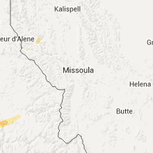
Wyoming
| Local Time | Report Details |
|---|---|
| 2:13 PM MDT | Greybull airport /gey in big horn county WY, 89.7 miles SSE of Billings, MT |
Alabama
| Local Time | Report Details |
|---|---|
| 3:37 PM CDT | Tim roof torn off a building and damaged a vehicle along county road 329 in geraldin in dekalb county AL, 61.9 miles SW of Chattanooga, TN |
| 4:10 PM CDT | Ema received several reports of trees and powerlines down near the intersection of mt. moriah rd and shiloh church r in clay county AL, 56.5 miles NNW of Auburn, AL |
| 4:10 PM CDT | The roof was blown off a chicken house near the intersection of mt. moriah rd and lake gerald r in clay county AL, 56.9 miles N of Auburn, AL |
Missouri
| Local Time | Report Details |
|---|---|
| 4:55 PM CDT | Trees down blocking roads in tow in marion county MO, 44.1 miles SSE of Kahoka, MO |
| 5:15 PM CDT | Large tree fell on pickup truck on rte c btw rte bb and z. tree blocking railroad tracks in town in lewis county MO, 22.7 miles SSE of Kahoka, MO |
| 8:25 PM CDT | Tree downed at riverview lane in st. charles county MO, 20.6 miles WNW of Saint Louis, MO |
| 8:25 PM CDT | Tree downed at perry cate and hannah drive in st. charles county MO, 37.8 miles WNW of Saint Louis, MO |
| 8:30 PM CDT | Fallen tree took down a power line in st. louis county MO, 16.1 miles WSW of Saint Louis, MO |
Florida
| Local Time | Report Details |
|---|---|
| 6:20 PM EDT | Quarter sized hail reported near Madison, FL, 51.4 miles E of Tallahassee, FL, quarter size hail reported |
| 6:20 PM EDT | Tree down in madison county FL, 51.6 miles E of Tallahassee, FL |
| 6:20 PM EDT | Power line down in madison county FL, 51.4 miles E of Tallahassee, FL |
| 6:25 PM EDT | Tree down in madison county FL, 48.4 miles E of Tallahassee, FL |
Colorado
| Local Time | Report Details |
|---|---|
| 4:55 PM MDT | Awos station buena vista airport /aej in chaffee county CO, 87.7 miles SW of Denver, CO |
Montana
| Local Time | Report Details |
|---|---|
| 5:22 PM MDT | Mesonet station mosby 16ene/lufborough hill /mtluf in garfield county MT, 88.5 miles SSW of Glasgow, MT |
| 5:59 PM MDT | 58 mph thunderstorm wind gust near york road and wylie driv in lewis and clark county MT, 66.8 miles SSW of Great Falls, MT |
| 5:59 PM MDT | 58 mph wind gust near the intersection of york road and wylie driv in lewis and clark county MT, 67 miles SSW of Great Falls, MT |
| 6:44 PM MDT | Mesonet station king coulee /kigm8 in valley county MT, 32.6 miles SSW of Glasgow, MT |
| 10:12 PM MDT | 58 mph wind gust at the havre airpor in hill county MT, 4.2 miles WSW of Havre, MT |
Minnesota
| Local Time | Report Details |
|---|---|
| 7:35 PM CDT | Tree uprooted onto a house roo in marshall county MN, 77.1 miles SW of Roseau, MN |
| 8:15 PM CDT | Measured at a personal weather statio in polk county MN, 75.2 miles N of Fargo, ND |
| 8:25 PM CDT | Peak winds measured at the rwis station along highway in polk county MN, 68.9 miles N of Fargo, ND |
| 8:28 PM CDT | Large tree branches up to 12 inch diameter broken down in the mn state par in polk county MN, 73.7 miles N of Fargo, ND |
| 8:29 PM CDT | Quarter sized hail reported near East Grand Forks, MN, 72.1 miles N of Fargo, ND, mainly dime to nickel... with a few quaurter sized hail. very heavy rains. |
| 9:20 PM CDT | Trees broken down near irvine ave and arctic roa in beltrami county MN, 17.1 miles N of Bemidji, MN |
| 9:45 PM CDT | Quarter sized hail reported near Bemidji, MN, 10.8 miles NNW of Bemidji, MN |
| 10:18 PM CDT | Widespread tree damage and power outages reported across northern bemidj in beltrami county MN, 2.6 miles N of Bemidji, MN |
| 10:45 PM CDT | Valvoline highway sign blown down along mn highway 19 in beltrami county MN, 2.7 miles SSE of Bemidji, MN |
Idaho
| Local Time | Report Details |
|---|---|
| 6:50 PM PDT | Quarter sized hail reported near Grangeville, ID, 0.7 miles SW of Grangeville, ID, . |
| 6:52 PM PDT | Quarter sized hail reported near Grangeville, ID, 0.3 miles N of Grangeville, ID, downed trees and minor flooding reported on main street. . |
Maryland
| Local Time | Report Details |
|---|---|
| 10:20 PM EDT | Multiple large oak trees down in montgomery county MD, 28 miles SW of Baltimore, MD |
| 10:29 PM EDT | Numerous trees down in far southern portion of the count in montgomery county MD, 32.3 miles SW of Baltimore, MD |
| 10:35 PM EDT | Two large trees down at the intersection of river rd and goldsboro rd in montgomery county MD, 35.2 miles SW of Baltimore, MD |
| 12:00 AM EDT | Tree down on woodyard road at sherwood drive in prince georges county MD, 36.7 miles SSW of Baltimore, MD |
District of Columbia
| Local Time | Report Details |
|---|---|
| 10:58 PM EDT | Quarter sized hail reported near Washington, DC, 34.2 miles SW of Baltimore, MD, quarter size hail at intersection of 6th st ne and l st ne |
| 11:02 PM EDT | Quarter sized hail reported near Washington, DC, 34.8 miles SW of Baltimore, MD, quarter size hail near intersection of 9th st nw and e st nw |
| 11:05 PM EDT | Quarter sized hail reported near Washington, DC, 36.1 miles SW of Baltimore, MD, quarter sized hail at nationals park |
| 11:40 PM EDT | Straight path of tree damage across the mall near the washington monumen in district of columb county DC, 35.4 miles SW of Baltimore, MD |
New Mexico
| Local Time | Report Details |
|---|---|
| 10:34 PM MDT | A thunderstorm outflow produced a wind gust of 61 mph at the t or c airpor in sierra county NM, 66.7 miles ENE of Silver City, NM |
Delaware
| Local Time | Report Details |
|---|---|
| 3:16 AM EDT | Storm damage reported in sussex county DE, 25.2 miles N of Ocean City, MD |
| 3:26 AM EDT | Storm damage reported in sussex county DE, 25.2 miles N of Ocean City, MD |
Connect with Interactive Hail Maps