

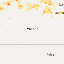
Hail Map for Saturday, July 22, 2017

Number of Impacted Households on 7/22/2017
0
Impacted by 1" or Larger Hail
0
Impacted by 1.75" or Larger Hail
0
Impacted by 2.5" or Larger Hail
Square Miles of Populated Area Impacted on 7/22/2017
0
Impacted by 1" or Larger Hail
0
Impacted by 1.75" or Larger Hail
0
Impacted by 2.5" or Larger Hail


Cities Most Affected by Hail Storms of 7/22/2017
| Hail Size | Demographics of Zip Codes Affected | ||||||
|---|---|---|---|---|---|---|---|
| City | Count | Average | Largest | Pop Density | House Value | Income | Age |
| Havensville, KS | 1 | 3.00 | 3.00 | 7 | $28k | $41.9k | 47.5 |
| Winter, WI | 1 | 1.75 | 1.75 | 4 | $81k | $29.9k | 55.0 |
Hail and Wind Damage Spotted on 7/22/2017
Filter by Report Type:Hail ReportsWind Reports
States Impacted
Ohio, West Virginia, Maryland, Virginia, District of Columbia, Florida, North Carolina, Kansas, Pennsylvania, Arizona, Texas, New Mexico, New Jersey, Wisconsin, Kentucky, Missouri, Illinois, IndianaOhio
| Local Time | Report Details |
|---|---|
| 8:07 AM EDT | Tree reported down in muskingum county OH, 54.1 miles ENE of Columbus, OH |
| 8:12 AM EDT | Tree reported down in muskingum county OH, 60.2 miles E of Columbus, OH |
| 4:08 PM EDT | Tree reported down on graham rd. north of hudson r in pickaway county OH, 15.1 miles SSW of Columbus, OH |
| 4:21 PM EDT | Tree reportedly fell on a power pol in pickaway county OH, 14 miles SSE of Columbus, OH |
| 4:43 PM EDT | A few trees reported down in town. time estimated from rada in athens county OH, 59.4 miles SE of Columbus, OH |
| 5:08 PM EDT | Large tree down on state rte. 266. time estimated from rada in morgan county OH, 74 miles ESE of Columbus, OH |
| 5:12 PM EDT | Few trees down along st rt 339 near barlow. time estimated via rada in washington county OH, 72.4 miles N of Charleston, WV |
| 5:22 PM EDT | Tree down along groves rd. time estimated from rada in washington county OH, 75 miles N of Charleston, WV |
| 5:28 PM EDT | Tree down along greenhill rd. time estimated from rada in washington county OH, 69.7 miles N of Charleston, WV |
| 5:57 PM EDT | A few trees reported down in town. time estimated from rada in athens county OH, 60.5 miles N of Charleston, WV |
| 6:48 PM EDT | Numerous trees and power lines down along locust grove rd. between eggleston rd. and king rd. time estimated from rada in vinton county OH, 52.4 miles SSE of Columbus, OH |
| 8:00 PM EDT | Tree down along rice rd. time estimated from rada in jackson county OH, 65.7 miles SSE of Columbus, OH |
West Virginia
| Local Time | Report Details |
|---|---|
| 12:52 PM EDT | Tree down blocking the roadway near the intersection of jenkins road and buck hill roa in berkeley county WV, 80.9 miles W of Baltimore, MD |
| 12:57 PM EDT | Wires down in the 900 block of runnymeade roa in berkeley county WV, 78.3 miles W of Baltimore, MD |
| 1:12 PM EDT | Three large trees down on route 9 near flowing springs roa in jefferson county WV, 66 miles W of Baltimore, MD |
| 1:19 PM EDT | Tree down in the 4100 block of chestnut hill roa in jefferson county WV, 60.6 miles W of Baltimore, MD |
| 1:20 PM EDT | Tree on house near the intersection of allens wonderland lane and bakerton roa in jefferson county WV, 61.3 miles W of Baltimore, MD |
| 3:30 PM EDT | Fire crews remove tree from us119 from near volga. time estimated via rada in barbour county WV, 18.8 miles NW of Elkins, WV |
| 3:57 PM EDT | Tree down on burnside addition in good hope. with pictures via facebook. time estimated from radar in lewis county WV, 33 miles WNW of Elkins, WV |
| 3:57 PM EDT | Tree down on burnside addition in good hope. with pictures via facebook. time estimated from radar in harrison county WV, 34.4 miles WNW of Elkins, WV |
| 4:05 PM EDT | Trees down along long run rd. time estimated from rada in harrison county WV, 32.6 miles WNW of Elkins, WV |
| 4:05 PM EDT | Trees down on pooh bear lane. time estimated from rada in harrison county WV, 33.6 miles WNW of Elkins, WV |
| 4:25 PM EDT | Tree down on route 90 near bayar in grant county WV, 35.3 miles NE of Elkins, WV |
| 4:30 PM EDT | Multiple softwood trees down per photos shared to social media. time estimated via rada in wood county WV, 63 miles N of Charleston, WV |
| 4:35 PM EDT | Tree down on route 42 just outside of maysvill in grant county WV, 38.7 miles ENE of Elkins, WV |
| 4:35 PM EDT | Quarter sized hail reported near Parkersburg, WV, 64.4 miles N of Charleston, WV, time estimated from radar |
| 4:36 PM EDT | Half Dollar sized hail reported near Parkersburg, WV, 65 miles N of Charleston, WV, former airport weather observer reports 1.25 hail near parkersburg/vienna border |
| 5:20 PM EDT | Several trees down in the glendale community. time estimated from rada in ritchie county WV, 69.2 miles NNE of Charleston, WV |
| 5:40 PM EDT | Trees down all over north bend state park per park ranger in ritchie county WV, 65.1 miles NNE of Charleston, WV |
| 5:52 PM EDT | Multiple trees down in monongalia county WV, 56.5 miles SSW of Pittsburgh, PA |
| 5:58 PM EDT | Trees down along progress ridge rd. time estimated from rada in wood county WV, 59.6 miles NNE of Charleston, WV |
| 6:30 PM EDT | Multiple trees down on halleck road in monongalia county WV, 41.3 miles NNW of Elkins, WV |
| 7:04 PM EDT | Trees and powerlines down. time estimated via rada in upshur county WV, 24.7 miles W of Elkins, WV |
| 7:15 PM EDT | Took out cell tower service and powe in upshur county WV, 24.7 miles WSW of Elkins, WV |
| 10:55 PM EDT | Several reports of trees down in the cit in cabell county WV, 43.1 miles W of Charleston, WV |
| 11:02 PM EDT | Trees reported down along 5200 block of route 6 in cabell county WV, 37.2 miles W of Charleston, WV |
| 11:25 PM EDT | Tree down on house in hamlin. other trees reported down in tow in lincoln county WV, 25.5 miles W of Charleston, WV |
Maryland
| Local Time | Report Details |
|---|---|
| 1:23 PM EDT | *** 1 inj *** tree fell on a car on route 340 at potomac river crossin in washington county MD, 59 miles W of Baltimore, MD |
| 1:30 PM EDT | Tree down on east stree in frederick county MD, 54.2 miles W of Baltimore, MD |
| 1:30 PM EDT | Tree down in the 600 block of east potomac stree in frederick county MD, 54.2 miles W of Baltimore, MD |
| 1:31 PM EDT | Tree down on power lines near the intersection of petersville road and rosemont driv in frederick county MD, 54.2 miles W of Baltimore, MD |
| 1:31 PM EDT | Tree down in the 100 block of gum spring roa in frederick county MD, 53.6 miles W of Baltimore, MD |
| 1:35 PM EDT | Tree down near the intersection of point of rocks road and west boss arnold roa in frederick county MD, 52.1 miles W of Baltimore, MD |
| 1:36 PM EDT | Tree down blocking one lane in the 3600 block of point of rocks roa in frederick county MD, 49.9 miles W of Baltimore, MD |
| 1:38 PM EDT | Tree down in roadway in the 2900 block of fry roa in frederick county MD, 49.9 miles W of Baltimore, MD |
| 1:47 PM EDT | Tree down near the intersection of darnestown road and beallsville roa in montgomery county MD, 43.6 miles W of Baltimore, MD |
| 1:50 PM EDT | Tree down near the intersection of peters road and roderick roa in frederick county MD, 41.8 miles W of Baltimore, MD |
| 1:58 PM EDT | Downed tree blocking both directions of travel on riffleford road between md-28 and md-11 in montgomery county MD, 37.1 miles WSW of Baltimore, MD |
| 1:59 PM EDT | Tree down blocking southbound germantown road just south of black road roa in montgomery county MD, 38 miles WSW of Baltimore, MD |
| 2:03 PM EDT | Storm damage reported in montgomery county MD, 34.4 miles WSW of Baltimore, MD |
| 2:03 PM EDT | Tree down blocking right side of river road east of travilah roa in montgomery county MD, 39.4 miles WSW of Baltimore, MD |
| 2:07 PM EDT | Wires down in the 700 block of beall avenu in montgomery county MD, 33.1 miles WSW of Baltimore, MD |
| 2:09 PM EDT | Wires down in the 2000 block of rockland avenu in montgomery county MD, 31.3 miles WSW of Baltimore, MD |
| 2:14 PM EDT | Tree down on car on elnora street between galt avenue and grandview avenu in montgomery county MD, 29.3 miles SW of Baltimore, MD |
| 2:15 PM EDT | Silver maple tree split in half by thunderstorm winds on henlopen cour in montgomery county MD, 28.9 miles SW of Baltimore, MD |
| 2:16 PM EDT | Large tree branch blocking lanes on little falls just before bradley boulevard at safewa in montgomery county MD, 34 miles SW of Baltimore, MD |
| 2:19 PM EDT | Wires down in the 600 block of philadelphia avenu in montgomery county MD, 30.3 miles SW of Baltimore, MD |
| 2:28 PM EDT | 4 inch limb snapped of in montgomery county MD, 30 miles SW of Baltimore, MD |
| 2:30 PM EDT | Tree down blocking golden pass lan in prince georges county MD, 20.5 miles SW of Baltimore, MD |
| 2:33 PM EDT | 2.5 inch diamter limb of bradford pear snappe in prince georges county MD, 20 miles SW of Baltimore, MD |
| 2:48 PM EDT | Tree down near the intersection of rossback road and rutland roa in anne arundel county MD, 22.2 miles S of Baltimore, MD |
| 2:50 PM EDT | Tree down near the intersection of solomons island road and harwood roa in anne arundel county MD, 29 miles S of Baltimore, MD |
| 2:53 PM EDT | Tree down near the intersection of brick church road and solomons island roa in anne arundel county MD, 26.3 miles S of Baltimore, MD |
| 2:54 PM EDT | Tree down in the 2900 block of friends roa in anne arundel county MD, 22.9 miles S of Baltimore, MD |
| 2:55 PM EDT | Several large tree limbs and at least one whole tree down in the southaven neighborhood of annapoli in anne arundel county MD, 22.1 miles S of Baltimore, MD |
| 2:58 PM EDT | Tree down near the intersection of chesapeake place and dock roa in anne arundel county MD, 14.6 miles SE of Baltimore, MD |
| 2:58 PM EDT | Two trees down near the intersection of southern maryland boulevard and talbot roa in anne arundel county MD, 35.3 miles S of Baltimore, MD |
| 3:00 PM EDT | Tree down near the intersection of fairhaven road and revell roa in anne arundel county MD, 37.4 miles S of Baltimore, MD |
| 3:00 PM EDT | Storm damage reported in anne arundel county MD, 22.8 miles SSE of Baltimore, MD |
| 3:18 PM EDT | Storm damage reported in queen anne's county MD, 29.2 miles SSE of Baltimore, MD |
| 3:40 PM EDT | Trees down on power line in wicomico county MD, 28 miles WNW of Ocean City, MD |
| 3:41 PM EDT | Trees down on power lines in salisbur in wicomico county MD, 28.1 miles W of Ocean City, MD |
| 3:43 PM EDT | Tree down. time estimated from rada in talbot county MD, 45.8 miles SE of Baltimore, MD |
| 3:56 PM EDT | Two trees down blocking roadwa in talbot county MD, 52.6 miles SE of Baltimore, MD |
| 4:00 PM EDT | Trees down and a roof damaged along jamaica point roa in talbot county MD, 52.6 miles SE of Baltimore, MD |
| 4:40 PM EDT | Trees down on power line in wicomico county MD, 28 miles WNW of Ocean City, MD |
| 4:41 PM EDT | Trees down on power lines in salisbur in wicomico county MD, 28.1 miles W of Ocean City, MD |
| 6:17 PM EDT | Tree down near the intersection of poplar hill road and gardiner roa in charles county MD, 48 miles SSW of Baltimore, MD |
Virginia
| Local Time | Report Details |
|---|---|
| 1:28 PM EDT | Large tree down blocking picnic woods road near bolington roa in loudoun county VA, 57.5 miles W of Baltimore, MD |
| 1:33 PM EDT | Six inch in diameter tree down near the intersection of browns lane and sunset hill lan in loudoun county VA, 53 miles W of Baltimore, MD |
| 1:34 PM EDT | Six inch in diameter tree limb down blocking part of taylorstown road near hickory shade lan in loudoun county VA, 52.6 miles W of Baltimore, MD |
| 1:41 PM EDT | Tree down on power lines in the 15900 block of limestone school roa in loudoun county VA, 50.1 miles W of Baltimore, MD |
| 1:42 PM EDT | Tree down on willisville road near john mosby highwa in loudoun county VA, 69.8 miles WSW of Baltimore, MD |
| 2:12 PM EDT | Large tree down blocking old dominion drive east of towlston road near rocky ru in fairfax county VA, 40.9 miles WSW of Baltimore, MD |
| 3:18 PM EDT | Tree blocking one lane on snow creek road near old franklin turnpike in franklin county VA, 26.8 miles SE of Roanoke, VA |
| 3:20 PM EDT | Tree across smith mountain road near west gretna road in pittsylvania county VA, 28.4 miles SE of Roanoke, VA |
| 3:45 PM EDT | A couple of large trees down at a private residence. trees... one to two feet in diameter... were snapped in half. some of the debris was moved 40 yard in pittsylvania county VA, 49.9 miles ESE of Roanoke, VA |
| 4:25 PM EDT | Large tree branch snapped near highway 340 in shenandoa in page county VA, 72.6 miles ESE of Elkins, WV |
| 5:23 PM EDT | Several trees down and tents blown over at orange county fai in orange county VA, 55 miles NNW of Richmond, VA |
| 5:50 PM EDT | Several trees down on power lines and one down on a car along saint just road between catharpin road and mine run roa in orange county VA, 53.5 miles NNW of Richmond, VA |
| 6:18 PM EDT | Numerous trees down along brock road between old battlefield boulevard and courthouse roa in spotsylvania county VA, 48.1 miles N of Richmond, VA |
| 6:20 PM EDT | Several trees down...including one on a hous in spotsylvania county VA, 50.5 miles N of Richmond, VA |
| 6:21 PM EDT | Tree down on greystone cour in city of fredericks county VA, 56.9 miles N of Richmond, VA |
| 6:29 PM EDT | Two trees down in the vicinity of the intersection of mills drive and tidewater trai in spotsylvania county VA, 51.8 miles NNE of Richmond, VA |
| 6:40 PM EDT | Trees down on rt. 2 near stonewall jackson r in caroline county VA, 48.1 miles NNE of Richmond, VA |
| 7:50 PM EDT | Tree down on johnville rd. near dunnsvill in essex county VA, 52.1 miles ENE of Richmond, VA |
| 8:00 PM EDT | Several trees down on rt. 360 near haynesville correctional cente in richmond county VA, 61.9 miles ENE of Richmond, VA |
| 8:12 PM EDT | Tree down on citrus mill pond r in northumberland county VA, 70.8 miles ENE of Richmond, VA |
| 9:42 PM EDT | Tree down near the intersection of amicus road and jonquill roa in greene county VA, 67.1 miles NW of Richmond, VA |
| 9:42 PM EDT | Tree down near the intersection of amicus road and jonquill roa in greene county VA, 67.1 miles NW of Richmond, VA |
| 9:42 PM EDT | Tree down near the intersection of amicus road and jonquill roa in greene county VA, 67.1 miles NW of Richmond, VA |
| 9:50 PM EDT | Tree down near the intersection of amicus road and jonquill road. trees also down on west daffodil road and gardenia road...including several into house in greene county VA, 67.1 miles NW of Richmond, VA |
| 10:00 PM EDT | Tree down in the 6400 block of scuffletown roa in orange county VA, 61 miles NNW of Richmond, VA |
| 10:08 PM EDT | Tree into structure in the 600 block of cabell avenu in city of charlottes county VA, 59.4 miles NW of Richmond, VA |
| 10:15 PM EDT | Tree down near the intersection of john warner parkway and east rio roa in albemarle county VA, 58.6 miles NW of Richmond, VA |
| 10:30 PM EDT | Tree down on power lines on madison avenu in city of charlottes county VA, 59.4 miles NW of Richmond, VA |
| 10:35 PM EDT | Tree down in the 3000 block of rolling roa in albemarle county VA, 53.9 miles NW of Richmond, VA |
| 10:42 PM EDT | Tree down in the 2500 block of buck island roa in albemarle county VA, 52.5 miles NW of Richmond, VA |
| 10:48 PM EDT | Trees down in the union mills are in fluvanna county VA, 46.2 miles NW of Richmond, VA |
| 10:51 PM EDT | Numerous trees down around tro in fluvanna county VA, 44.1 miles NW of Richmond, VA |
| 10:52 PM EDT | Tree down on us 15 near zion crossroad in louisa county VA, 44.8 miles NW of Richmond, VA |
| 10:52 PM EDT | Trees down on interstate 64 near zion crossroad in louisa county VA, 45.3 miles NW of Richmond, VA |
| 11:08 PM EDT | Tree down on a power line at the intersection of goode station road and forest road. the road was blocke in bedford county VA, 31.1 miles ENE of Roanoke, VA |
| 11:10 PM EDT | One tree down in the 200 block of buckingham road in the timberlake are in city of lynchburg county VA, 40.1 miles E of Roanoke, VA |
| 11:10 PM EDT | Two to three large trees down near the intersection of wigginton and chadwick road in city of lynchburg county VA, 39.9 miles ENE of Roanoke, VA |
| 11:12 PM EDT | One tree down near the intersection of link road and boonsboro roa in city of lynchburg county VA, 42.9 miles ENE of Roanoke, VA |
| 11:12 PM EDT | One tree day in the 2200 block of taylor farm roa in city of lynchburg county VA, 41.9 miles ENE of Roanoke, VA |
District of Columbia
| Local Time | Report Details |
|---|---|
| 2:22 PM EDT | Roof shingles peeled back by thunderstorm wind in district of columb county DC, 31.5 miles SW of Baltimore, MD |
Florida
| Local Time | Report Details |
|---|---|
| 3:08 PM EDT | Several trees were blown over and a small tree was uprooted in the mantanzas woods section of palm coas in flagler county FL, 55.7 miles SSE of Jacksonville, FL |
| 3:40 PM EDT | Tree reported down near colee cove roa in st. johns county FL, 26.8 miles S of Jacksonville, FL |
North Carolina
| Local Time | Report Details |
|---|---|
| 3:12 PM EDT | Several trees blown down at brown mtn beach campground. quarter size hail was also reporte in caldwell county NC, 54.4 miles SSE of Bristol, TN |
| 3:12 PM EDT | County official reports one tree blown down in southwest collettesvill in caldwell county NC, 55.3 miles SSE of Bristol, TN |
| 3:45 PM EDT | A couple of large trees down at a private residence. trees... one to two feet in diameter... were snapped in half. some of the debris was moved 40 yard in surry county NC, 63.9 miles SSW of Roanoke, VA |
| 4:28 PM EDT | Several trees down in the vicinity of north carolina highway 66 abd taylor roa in stokes county NC, 64.5 miles SSW of Roanoke, VA |
| 4:43 PM EDT | Several trees down in the vicinity of north carolina highway 66 and moores spring roa in stokes county NC, 64.3 miles SSW of Roanoke, VA |
| 5:02 PM EDT | Forsyth county 911 received report of two trees down across road on donnaha rd in tobaccovill in forsyth county NC, 74.5 miles NNE of Charlotte, NC |
| 5:02 PM EDT | Forsyth county 911 received report of two trees down across road at 5000 block of spainhour mill rd in tobaccovill in forsyth county NC, 74.6 miles NNE of Charlotte, NC |
| 5:20 PM EDT | Emergency manager reports mulitple trees blown down across several street in mcdowell county NC, 64 miles S of Bristol, TN |
| 5:28 PM EDT | Forsyth county 911 received report of a tree down across road at stanley park rd and reidsville rd in winston sale in forsyth county NC, 73.6 miles NNE of Charlotte, NC |
| 5:38 PM EDT | Forsyth county 911 received report of a tree down across road at grape wine rd and sonata rd in lewisvill in forsyth county NC, 65.5 miles NNE of Charlotte, NC |
Kansas
| Local Time | Report Details |
|---|---|
| 4:29 PM CDT | Also pea sized hail and heavy rain reporte in graham county KS, 34 miles WNW of Hays, KS |
| 4:36 PM CDT | Half Dollar sized hail reported near Plainville, KS, 32 miles NNE of Hays, KS |
| 4:58 PM CDT | Quarter sized hail reported near Plainville, KS, 31.4 miles NNE of Hays, KS |
| 5:00 PM CDT | Power lines down. time estimated from rada in trego county KS, 33.3 miles WNW of Hays, KS |
| 5:03 PM CDT | Quarter sized hail reported near Cawker City, KS, 65.1 miles NE of Hays, KS, nickel to quarter sized hail. winds est 20 to 30mph with storm. |
| 5:27 PM CDT | Storm damage reported in trego county KS, 21.4 miles WNW of Hays, KS |
| 5:30 PM CDT | Tea Cup sized hail reported near Havensville, KS, 31.2 miles ENE of Manhattan, KS, picture evidence of hail from twitter shared by media. |
| 5:33 PM CDT | Quarter sized hail reported near Westmoreland, KS, 16.7 miles NNE of Manhattan, KS |
| 6:00 PM CDT | Quarter sized hail reported near Hunter, KS, 57 miles ENE of Hays, KS, quarter sized hail with heavy rain. |
| 7:29 PM CDT | Measured at the topeka billard airpor in shawnee county KS, 50.6 miles E of Manhattan, KS |
| 7:48 PM CDT | Measured at the concordia airpor in cloud county KS, 63.7 miles WNW of Manhattan, KS |
| 8:00 PM CDT | Power lines down. time estimated from rada in jefferson county KS, 54.8 miles ENE of Manhattan, KS |
| 9:42 PM CDT | Two trees blown down. both 8 inches in diameter. fell over the roadway in leavenworth county KS, 23.5 miles WSW of Kansas City, MO |
| 9:47 PM CDT | A street light snapped and a fence was blown dow in johnson county KS, 11.9 miles SW of Kansas City, MO |
| 9:47 PM CDT | Two trees snapped at the base. one was about 14-16 inches in diameter... the other about 12-14 inches in diameter. one tree was blocking the road but has been cleare in johnson county KS, 12.3 miles SW of Kansas City, MO |
| 9:52 PM CDT | Measured with home weather station...relayed via johnson county sheriffs office. west 87th circle in johnson county KS, 22.5 miles WSW of Kansas City, MO |
| 9:56 PM CDT | Storm damage reported in johnson county KS, 8.6 miles SW of Kansas City, MO |
| 10:05 PM CDT | Storm damage reported in johnson county KS, 12.3 miles SW of Kansas City, MO |
| 10:15 PM CDT | 60 to 70 mph winds in johnson county KS, 6.5 miles SW of Kansas City, MO |
| 10:30 PM CDT | Large trees blocking streets in wyandotte county KS, 2.7 miles WSW of Kansas City, MO |
| 11:14 PM CDT | Damage to trees in franklin county KS, 50.7 miles NNE of Chanute, KS |
| 11:40 PM CDT | About 15 large trees are down in the lenape area. some trees are 24 inches in diamete in johnson county KS, 20.2 miles WSW of Kansas City, MO |
| 11:40 PM CDT | Two trees snapped at the base. one was about 14-16 inches in diameter... the other about 12-14 inches in diameter. one tree was blocking the road but has been cleare in johnson county KS, 12.3 miles SW of Kansas City, MO |
Pennsylvania
| Local Time | Report Details |
|---|---|
| 5:40 PM EDT | Tree down on ship road and pullman drive in chester county PA, 73 miles NE of Baltimore, MD |
| 5:45 PM EDT | Wires down on ashbridge roa in chester county PA, 72.6 miles NE of Baltimore, MD |
| 5:50 PM EDT | Tree and wires down on dutton mill roa in chester county PA, 76.8 miles NE of Baltimore, MD |
| 5:59 PM EDT | Large tree down on crosskeys road in montgomery county PA, 84.2 miles WSW of Brooklyn, NY |
| 6:00 PM EDT | Trees dow in delaware county PA, 83.1 miles NE of Baltimore, MD |
| 6:00 PM EDT | Wires down at dekalb and fornance street in montgomery county PA, 81.4 miles WSW of Brooklyn, NY |
| 6:20 PM EDT | Tree down at ridge avenue and huntingdon stree in philadelphia county PA, 80.2 miles SW of Brooklyn, NY |
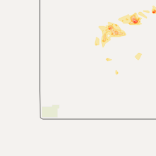
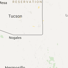
Arizona
| Local Time | Report Details |
|---|---|
| 2:55 PM MST | Report of power lines down along highway 389 at mile marker 7. kazc reported a wind gust of 44 mp in mohave county AZ, 34.9 miles ESE of Saint George, UT |
| 4:49 PM MST | Wind gust associated with a wet microburst. a few aircraft were moved/turned by the wind. no damage reported. the duration of the tstm wnd gst event was 30 minute in yavapai county AZ, 57.7 miles SW of Flagstaff, AZ |
Texas
| Local Time | Report Details |
|---|---|
| 5:18 PM CDT | Thunderstorm wind gust reported at midland international air and space por in midland county TX, 13.8 miles ENE of Odessa, TX |
| 6:05 PM CDT | Storm damage reported in garza county TX, 39 miles SE of Lubbock, TX |
| 6:20 PM CDT | Storm damage reported in garza county TX, 40.3 miles SSE of Lubbock, TX |
| 6:25 PM CDT | Downed powerlines at w. 6th st. and katherine s in crane county TX, 31.7 miles S of Odessa, TX |
New Mexico
| Local Time | Report Details |
|---|---|
| 4:30 PM MDT | Wiind gust of 58 mph measured at weather statio in dona ana county NM, 11 miles NW of El Paso, TX |
| 5:15 PM MDT | Kcvs aso in curry county NM, 59.3 miles SSE of Tucumcari, NM |
| 5:19 PM MDT | Kcvs aso in curry county NM, 59.3 miles SSE of Tucumcari, NM |
| 6:10 PM MDT | 3 and 1 2 inch diameter branches dow in roosevelt county NM, 51.4 miles S of Tucumcari, NM |
| 6:10 PM MDT | 3 and 1 2 inch diameter branches dow in roosevelt county NM, 51.4 miles S of Tucumcari, NM |
| 6:10 PM MDT | 3 and 1 2 inch diameter branches dow in roosevelt county NM, 51.4 miles S of Tucumcari, NM |
New Jersey
| Local Time | Report Details |
|---|---|
| 6:32 PM EDT | Storm damage reported in camden county NJ, 78.7 miles SW of Brooklyn, NY |
| 6:35 PM EDT | Tree limb down on ca in camden county NJ, 78.4 miles SW of Brooklyn, NY |
| 6:35 PM EDT | Tree dow in camden county NJ, 79.4 miles SW of Brooklyn, NY |
| 6:35 PM EDT | Tree down on a trailer on mount ephraim avenu in camden county NJ, 79.2 miles SW of Brooklyn, NY |
| 7:05 PM EDT | Tree down on gottliebs field roa in burlington county NJ, 70.1 miles SW of Brooklyn, NY |
| 7:08 PM EDT | Tree down gottlieb field rd.. time est 88 in burlington county NJ, 70.1 miles SW of Brooklyn, NY |
Wisconsin
| Local Time | Report Details |
|---|---|
| 7:58 PM CDT | Golf Ball sized hail reported near Winter, WI, 80.8 miles SE of Duluth, MN |
Kentucky
| Local Time | Report Details |
|---|---|
| 9:36 PM EDT | Tree reported down in maysville. time estimated from rada in mason county KY, 51.9 miles SE of Cincinnati, OH |
| 9:47 PM EDT | Trees and power lines reported down on laytham pike near mays lick. time estimated from rada in mason county KY, 54.6 miles SE of Cincinnati, OH |
| 12:40 AM EDT | Trees blown down. damage to a trailer home. garage pushed back a couple of feet by the win in fleming county KY, 51.3 miles NNE of Irvine, KY |
| 12:45 AM EDT | Canopy of a gas station blown down. also trees down in the are in fleming county KY, 51.3 miles NNE of Irvine, KY |
| 2:42 AM EDT | Trees were blown down on ridgeway drive in morehead... on both ends of highway 60 in morehead... and on the north end of highway 32 in morehea in rowan county KY, 44.7 miles NE of Irvine, KY |
Missouri
| Local Time | Report Details |
|---|---|
| 9:24 PM CDT | Off-duty nws staff in jackson county MO, 21.2 miles SSE of Kansas City, MO |
| 10:23 PM CDT | Storm damage reported in jackson county MO, 2.5 miles SSW of Kansas City, MO |
| 10:27 PM CDT | Tree limbs down the size of cars in jackson county MO, 8.8 miles E of Kansas City, MO |
| 10:32 PM CDT | Trees and power lines down in clay county MO, 9.8 miles NE of Kansas City, MO |
| 10:38 PM CDT | Numerous trees down in jackson county MO, 17.2 miles SE of Kansas City, MO |
| 10:40 PM CDT | Numerous trees and large limbs down across the country club plaza and ward parkway areas in jackson county MO, 5 miles S of Kansas City, MO |
| 10:41 PM CDT | Large limbs down in jackson county MO, 17.3 miles ESE of Kansas City, MO |
| 10:42 PM CDT | Numerous trees down in clay county MO, 2.2 miles NNE of Kansas City, MO |
| 10:42 PM CDT | Large limbs down in jackson county MO, 17.3 miles ESE of Kansas City, MO |
| 10:45 PM CDT | Large limbs down in clay county MO, 9.8 miles NE of Kansas City, MO |
| 10:47 PM CDT | Large trees down in jackson county MO, 21.6 miles ESE of Kansas City, MO |
| 10:48 PM CDT | Large tree down in jackson county MO, 7.7 miles E of Kansas City, MO |
| 10:50 PM CDT | Ripped blades off porch ceiling fan in clay county MO, 13.4 miles NE of Kansas City, MO |
| 11:00 PM CDT | Trees and powerlines down. received via social medi in lafayette county MO, 38.7 miles E of Kansas City, MO |
| 11:55 PM CDT | Large tree down in saline county MO, 48 miles WNW of Columbia, MO |
| 12:55 AM CDT | Storm damage reported in randolph county MO, 32.8 miles N of Columbia, MO |
| 2:30 AM CDT | Large tree blown down...near highway 47 and benjamin driv in lincoln county MO, 51.6 miles WNW of Saint Louis, MO |
| 2:32 AM CDT | Storm damage reported in lincoln county MO, 48.6 miles WNW of Saint Louis, MO |
| 2:45 AM CDT | Tree down. possible roof damag in lincoln county MO, 52.1 miles WNW of Saint Louis, MO |
| 2:51 AM CDT | *** 3 inj *** camper rolled over at 370 lakeside rv campground. three people trapped...with minor injuries. two other campers moved off their bases but not rolled ove in st. charles county MO, 24.5 miles WNW of Saint Louis, MO |
| 3:02 AM CDT | Storm damage reported in st. charles county MO, 24 miles NNW of Saint Louis, MO |
| 3:04 AM CDT | 3 inch diameter limbs down in st. louis county MO, 10 miles NNW of Saint Louis, MO |
Illinois
| Local Time | Report Details |
|---|---|
| 11:55 PM CDT | At olney-noble airport in richland county IL, 53.1 miles SSE of Mattoon, IL |
| 12:05 AM CDT | Tree snapped. time estimated from rada in richland county IL, 54.1 miles SSE of Mattoon, IL |
| 2:32 AM CDT | Storm damage reported in madison county IL, 18.2 miles ENE of Saint Louis, MO |
| 3:17 AM CDT | Storm damage reported in madison county IL, 6.8 miles NNE of Saint Louis, MO |
| 3:20 AM CDT | Six inch tree limb blown dow in madison county IL, 23.6 miles N of Saint Louis, MO |
| 3:30 AM CDT | Tree limbs dow in macoupin county IL, 28.6 miles N of Saint Louis, MO |
| 3:30 AM CDT | Tree snapped of unknown siz in madison county IL, 15.4 miles NE of Saint Louis, MO |
| 3:30 AM CDT | Numerous trees downe in madison county IL, 24 miles ENE of Saint Louis, MO |
| 3:33 AM CDT | Storm damage reported in madison county IL, 21.1 miles NNE of Saint Louis, MO |
| 3:35 AM CDT | Quarter sized hail reported near Belleville, IL, 12.7 miles ESE of Saint Louis, MO, near intersection of routes 15 and 158. |
| 3:41 AM CDT | Storm damage reported in st. clair county IL, 19.7 miles ESE of Saint Louis, MO |
| 3:56 AM CDT | Large tree limb blown dow in madison county IL, 24.1 miles ENE of Saint Louis, MO |
| 4:15 AM CDT | Tree down in clinton county IL, 44.9 miles E of Saint Louis, MO |
| 4:20 AM CDT | Large limbs down in bond county IL, 54.1 miles ENE of Saint Louis, MO |
| 4:50 AM CDT | Estimated winds of 65 to 70 mph along marion/clay county line...west of xeni in marion county IL, 61.3 miles SSW of Mattoon, IL |
| 4:50 AM CDT | Storm damage reported in clay county IL, 60.2 miles SSW of Mattoon, IL |
| 4:52 AM CDT | Multiple tree limbs down. one mid size tree snapped about halfway u in clay county IL, 59.8 miles SSW of Mattoon, IL |
| 5:05 AM CDT | Severe winds persistent for up to 10 minute in wayne county IL, 55.6 miles NW of Evansville, IN |
| 5:15 AM CDT | Storm damage reported in clay county IL, 56.3 miles S of Mattoon, IL |
| 5:26 AM CDT | At olney-noble airport in richland county IL, 53.1 miles SSE of Mattoon, IL |
| 5:31 AM CDT | At olney-noble airport in richland county IL, 53.1 miles SSE of Mattoon, IL |
| 5:32 AM CDT | Several tree limbs and power lines down in richland county IL, 54.1 miles SSE of Mattoon, IL |
| 5:35 AM CDT | Storm damage reported in white county IL, 29.8 miles WNW of Evansville, IN |
Indiana
| Local Time | Report Details |
|---|---|
| 1:31 AM EDT | Trees down...power pole dow in orange county IN, 60.9 miles NW of Louisville, KY |
| 2:22 AM EDT | Tree dow in clark county IN, 20.2 miles N of Louisville, KY |
| 3:04 AM EDT | One tree dow in dubois county IN, 52.2 miles ENE of Evansville, IN |
| 3:09 AM EDT | One tree dow in dubois county IN, 53.2 miles ENE of Evansville, IN |
| 3:15 AM EDT | A few trees dow in crawford county IN, 39.1 miles NW of Louisville, KY |
| 5:15 AM CDT | Trees down... and road signs blown off the roa in warrick county IN, 20.3 miles NE of Evansville, IN |
| 7:00 AM EDT | Emergency manager reports large tree down near intersection of 3rd st and shelby st in vincennes. time estimated from rada in knox county IN, 48.5 miles N of Evansville, IN |
| 7:02 AM EDT | Emergency manager reports a tree down near old us 50 and hyde park drive. time estimated from rada in knox county IN, 48.8 miles N of Evansville, IN |
Connect with Interactive Hail Maps