

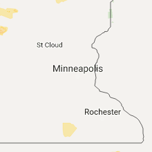
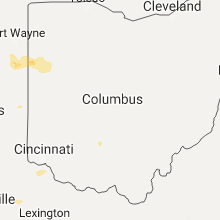
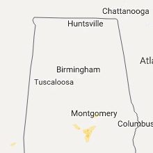
Hail Map for Friday, July 21, 2017

Number of Impacted Households on 7/21/2017
0
Impacted by 1" or Larger Hail
0
Impacted by 1.75" or Larger Hail
0
Impacted by 2.5" or Larger Hail
Square Miles of Populated Area Impacted on 7/21/2017
0
Impacted by 1" or Larger Hail
0
Impacted by 1.75" or Larger Hail
0
Impacted by 2.5" or Larger Hail


Cities Most Affected by Hail Storms of 7/21/2017
| Hail Size | Demographics of Zip Codes Affected | ||||||
|---|---|---|---|---|---|---|---|
| City | Count | Average | Largest | Pop Density | House Value | Income | Age |
| Mandan, ND | 2 | 2.63 | 2.75 | 38 | $83k | $39.5k | 37.6 |
| Ericson, NE | 1 | 2.75 | 2.75 | 2 | $33k | $26.2k | 52.1 |
| Bagley, MN | 1 | 2.00 | 2.00 | 12 | $59k | $30.8k | 40.2 |
| Mohall, ND | 1 | 1.75 | 1.75 | 1 | $40k | $31.3k | 46.2 |
| Maxbass, ND | 1 | 1.75 | 1.75 | 1 | $14k | $31.0k | 48.6 |
| Bismarck, ND | 1 | 1.75 | 1.75 | 1135 | $100k | $41.5k | 38.3 |
| Hague, ND | 1 | 1.75 | 1.75 | 1 | $16k | $24.6k | 44.5 |
| Bartlett, NE | 1 | 1.75 | 1.75 | 1 | $31k | $32.1k | 46.1 |
| Lehr, ND | 1 | 1.75 | 1.75 | 1 | $10k | $24.4k | 54.3 |
Hail and Wind Damage Spotted on 7/21/2017
Filter by Report Type:Hail ReportsWind Reports
States Impacted
Ohio, North Dakota, Florida, Georgia, Virginia, Illinois, Minnesota, Alabama, South Carolina, Maine, Iowa, Wisconsin, Arizona, Nebraska, Colorado, South Dakota, IndianaOhio
| Local Time | Report Details |
|---|---|
| 8:00 AM EDT | Multiple limbs downed near intersection of hominy ridge rd. and goldfinch rd. time estimated by rada in clark county OH, 45.5 miles W of Columbus, OH |
| 8:00 AM EDT | Several trees downed in st. paris area. time estimated by rada in champaign county OH, 52.1 miles WNW of Columbus, OH |
| 8:02 AM EDT | Tree downed near intersection of fairfield pike and springfield xenia rd. time estimated by rada in clark county OH, 44.8 miles W of Columbus, OH |
| 8:03 AM EDT | Large tree downed near intersection of st. paris pike and w. 2nd street. time estimated by rada in clark county OH, 43.4 miles W of Columbus, OH |
| 8:11 AM EDT | Tree fell on car in 2600 block of e county line rd. time estimated by rada in champaign county OH, 39.9 miles W of Columbus, OH |
| 8:13 AM EDT | Several trees down in vicinity of county line rd. and rte 4. time estimated by rada in clark county OH, 36.1 miles W of Columbus, OH |
| 8:15 AM EDT | Trees and powerlines down along a portion of reynolds street. time estimated by rada in champaign county OH, 40.7 miles WNW of Columbus, OH |
| 8:26 AM EDT | Large tree downed on old columbus road. time estimated by rada in madison county OH, 26.9 miles W of Columbus, OH |
| 8:30 AM EDT | Tree downed near intersection of arbuckle rd. and green lane. time estimated by rada in madison county OH, 24.3 miles W of Columbus, OH |
| 9:24 AM EDT | Storm damage reported in franklin county OH, 8.9 miles NNW of Columbus, OH |
| 11:20 PM EDT | One large tree down. time estimate in scioto county OH, 75.4 miles S of Columbus, OH |
| 7:04 AM EDT | Large limb downe in franklin county OH, 7.5 miles WNW of Columbus, OH |
| 7:06 AM EDT | A few trees downed. chimney toppled and shingles off roo in franklin county OH, 9 miles NW of Columbus, OH |
North Dakota
| Local Time | Report Details |
|---|---|
| 10:05 AM CDT | Quarter sized hail reported near Hannah, ND, 61.1 miles N of Devils Lake, ND, reported by border patrol. |
| 3:18 PM CDT | Measured 74 mph gust with 3/4" hail. door torn off of a quonset hut... and some siding was ripped off a house. large area of corn flattened. time estimated from rada in foster county ND, 41.8 miles SSE of Devils Lake, ND |
| 3:18 PM CDT | Quarter sized hail reported near Glenfield, ND, 43.1 miles S of Devils Lake, ND, quarter sized hail estimated. was also wind driven... so broke out windows... dented cars... and stripped some paint off siding. time estimated from radar. |
| 3:18 PM CDT | One foot diameter trees down. broken windows from wind driven quarter size hail. a grain truck knocked over... and wind driven hail stripped paint of siding. time estim in foster county ND, 43.1 miles S of Devils Lake, ND |
| 3:22 PM CDT | Multiple power lines down. multiple trees down. tractor trailer truck blown over. time estimated on rada in foster county ND, 47 miles SSE of Devils Lake, ND |
| 3:51 PM CDT | Peak wind measured at an ndawn statio in griggs county ND, 55.9 miles SE of Devils Lake, ND |
| 6:10 PM CDT | Quarter sized hail reported near Hankinson, ND, 64.6 miles SSW of Fargo, ND, mostly pea to dime size. |
| 7:18 PM CDT | Quarter sized hail reported near , , 69.4 miles NW of Minot, ND, multiple reports of quarter size hail. |
| 7:30 PM CDT | Golf Ball sized hail reported near Hague, ND, 59.4 miles SE of Bismarck, ND, the duration of the hail event was 10 minutes. |
| 8:05 PM CDT | Quarter sized hail reported near Mohall, ND, 45.6 miles NNW of Minot, ND, relayed by broadcast media. |
| 8:07 PM CDT | Quarter sized hail reported near Max, ND, 29.4 miles S of Minot, ND, relayed by broadcast media. |
| 8:08 PM CDT | Golf Ball sized hail reported near Mohall, ND, 44.7 miles NNW of Minot, ND, golf ball size hail. |
| 8:32 PM CDT | Golf Ball sized hail reported near Lehr, ND, 72.1 miles ESE of Bismarck, ND |
| 8:38 PM CDT | Quarter sized hail reported near Washburn, ND, 35.5 miles NNW of Bismarck, ND, relayed by broadcast media. |
| 8:40 PM CDT | Golf Ball sized hail reported near Maxbass, ND, 39.6 miles N of Minot, ND |
| 8:48 PM CDT | Quarter sized hail reported near Maxbass, ND, 34.9 miles NNE of Minot, ND |
| 9:24 PM CDT | Quarter sized hail reported near Kramer, ND, 41.3 miles NE of Minot, ND, quarter sized hail continues. |
| 9:55 PM CDT | 60 mph winds were accompanied by 1 inch hai in dickey county ND, 51.5 miles NNW of Aberdeen, SD |
| 10:00 PM CDT | Half Dollar sized hail reported near Ellendale, ND, 49.9 miles NNW of Aberdeen, SD |
| 10:10 PM CDT | Tennis Ball sized hail reported near Mandan, ND, 5.5 miles WNW of Bismarck, ND |
| 10:25 PM CDT | Baseball sized hail reported near Mandan, ND, 5.4 miles W of Bismarck, ND, tennis to baseball size hail near the ball field on 3rd street sw. |
| 10:25 PM CDT | Golf Ball sized hail reported near Bismarck, ND, 1.1 miles NNW of Bismarck, ND |
| 11:10 PM CDT | Quarter sized hail reported near Verona, ND, 66 miles NNE of Aberdeen, SD, public report relayed by stutsman county law enforcement. |
| 11:47 PM CDT | Long lake wildlife refug in burleigh county ND, 27 miles ESE of Bismarck, ND |
| 2:42 AM CDT | Personal weather station in cass county ND, 28.5 miles NW of Fargo, ND |
Florida
| Local Time | Report Details |
|---|---|
| 12:55 PM EDT | Tree snapped by winds near jog road and west atlantic avenue. photo relayed by wptv meteorologist. time estimated from rada in palm beach county FL, 49.9 miles N of Miami, FL |
| 1:17 PM EDT | Large tree pushed over by strong winds in greenacres. photo relayed by wptv meteorologis in palm beach county FL, 46.8 miles SSE of Port Saint Lucie, FL |
| 2:40 PM EDT | Broadcast media relayed photos of wind damage at florida flying gators ultralight airport. preliminary wind estimate 60 mph. time approximate from rada in lake county FL, 26.5 miles WNW of Orlando, FL |
| 3:35 PM EDT | Florida highway patrol website reports trees and power lines down in killearn cente in leon county FL, 5.2 miles NNE of Tallahassee, FL |
| 3:35 PM EDT | Tree down blocking fred george road near springwood elementary in leon county FL, 5.9 miles NW of Tallahassee, FL |
| 5:57 PM EDT | Multiple trees down on 45th driv in suwannee county FL, 73.3 miles WSW of Jacksonville, FL |
| 6:45 PM EDT | Trees and powerlines down on 77th drive and cr-25 in suwannee county FL, 75.9 miles W of Jacksonville, FL |
Georgia
| Local Time | Report Details |
|---|---|
| 2:45 PM EDT | County dispatch reported tree down on us hwy 27 near amsterda in decatur county GA, 21.9 miles NNW of Tallahassee, FL |
| 2:45 PM EDT | County dispatch reported trees down in grady county along hwy 111 near calvar in grady county GA, 19.7 miles NNW of Tallahassee, FL |
| 5:30 PM EDT | County dispatch reported multiple trees down along hwy 84... including the intersection with patrick rd. also some standing water along hwy 8 in brooks county GA, 53 miles ENE of Tallahassee, FL |
Virginia
| Local Time | Report Details |
|---|---|
| 3:11 PM EDT | Several large tree limbs down blocking burgess road near east market stree in city of harrisonbu county VA, 62.4 miles ESE of Elkins, WV |
| 3:23 PM EDT | Tree down near the intersection of old valley pike and moreland gap roa in shenandoah county VA, 66.1 miles ESE of Elkins, WV |
| 5:54 PM EDT | Tree down on ferry road at the fire department in pittsylvania county VA, 54.7 miles SSE of Roanoke, VA |
Illinois
| Local Time | Report Details |
|---|---|
| 2:53 PM CDT | Numerous calls of trees and powerlines downed throughout the city in winnebago county IL, 57.9 miles SSE of Madison, WI |
| 3:00 PM CDT | Two trees were knocked down in rockfor in winnebago county IL, 57.9 miles SSE of Madison, WI |
| 4:25 PM CDT | Trees uprooted and larger branches broken off onto cars. estimated wind gust around 70 mp in kane county IL, 35.5 miles WNW of Chicago, IL |
| 4:25 PM CDT | 70 mph wind gust and downed tree branches and powerlines near pingree grov in kane county IL, 40.6 miles WNW of Chicago, IL |
| 4:25 PM CDT | Quarter sized hail reported near Elgin, IL, 40.6 miles WNW of Chicago, IL, 1 inch hail was reported near pingree grove. |
| 4:25 PM CDT | Estimated wind gust of 70-80 mph. hundreds of trees damaged on the east side of town. several roads closed due to fallen power line in kane county IL, 34.8 miles WNW of Chicago, IL |
| 4:49 PM CDT | Half Dollar sized hail reported near Schaumburg, IL, 25.2 miles WNW of Chicago, IL, winds estimated at 40-50 mph. |
| 4:50 PM CDT | Quarter sized hail reported near Elk Grove Village, IL, 20.4 miles WNW of Chicago, IL, quarter sized hail reported in elk grove village via facebook. |
| 4:53 PM CDT | Quarter sized hail reported near Elk Grove Village, IL, 20.4 miles WNW of Chicago, IL, lots of one quarter inch hail with a few quarter sized hailstones. |
| 4:55 PM CDT | Reports of trees down in itasca via faceboo in dupage county IL, 21 miles WNW of Chicago, IL |
| 4:55 PM CDT | Half Dollar sized hail reported near Itasca, IL, 21 miles WNW of Chicago, IL |
| 4:58 PM CDT | Quarter sized hail reported near Wood Dale, IL, 18.9 miles WNW of Chicago, IL |
| 4:58 PM CDT | Measured on personal weather statio in dupage county IL, 21.3 miles WNW of Chicago, IL |
| 5:00 PM CDT | Large branches dow in cook county IL, 20.4 miles WNW of Chicago, IL |
| 5:00 PM CDT | Half Dollar sized hail reported near Elk Grove Village, IL, 20.4 miles WNW of Chicago, IL |
| 7:16 PM CDT | Wind knocked down a 5 inch diameter healthy tree branch off of a silver maple tre in rock island county IL, 64.6 miles SE of Cedar Rapids, IA |
| 7:18 PM CDT | Power lines dow in rock island county IL, 65.4 miles SE of Cedar Rapids, IA |
| 7:21 PM CDT | Trees are down across the town of fulto in whiteside county IL, 78.4 miles E of Cedar Rapids, IA |
| 7:24 PM CDT | Barn blown dow in whiteside county IL, 79.8 miles E of Cedar Rapids, IA |
| 7:25 PM CDT | Storm damage reported in rock island county IL, 70.7 miles ESE of Cedar Rapids, IA |
| 12:15 AM CDT | Two homes on southwest corner of town near route 1 with roof damage...including one with partial roof loss. also downed power poles in area. time estimated by rada in iroquois county IL, 66.7 miles S of Chicago, IL |
Minnesota
| Local Time | Report Details |
|---|---|
| 3:40 PM CDT | Quarter sized hail reported near Kelliher, MN, 34.6 miles NNE of Bemidji, MN, mostly pea to marble sized hail. |
| 4:06 PM CDT | Peak winds measured at an rwis statio in beltrami county MN, 34.2 miles NE of Bemidji, MN |
| 4:20 PM CDT | Numerous large branches broken down around tow in polk county MN, 54.4 miles WNW of Bemidji, MN |
| 4:45 PM CDT | Branches down and power out. only had pea sized hai in polk county MN, 34 miles W of Bemidji, MN |
| 4:46 PM CDT | Storm damage reported in mahnomen county MN, 35.3 miles W of Bemidji, MN |
| 5:00 PM CDT | Winds blew out a window on a house and broke down numerous large branche in clearwater county MN, 23 miles W of Bemidji, MN |
| 5:00 PM CDT | Numerous trees blown dow in clearwater county MN, 24.5 miles W of Bemidji, MN |
| 5:04 PM CDT | Hen Egg sized hail reported near Bagley, MN, 23 miles W of Bemidji, MN, in addition to severe winds... large hail covered the ground. |
| 5:22 PM CDT | Metal roofing panels torn off of a barn. location and time estimated pending further reportin in hubbard county MN, 10.8 miles SW of Bemidji, MN |
| 5:37 PM CDT | Peak winds measured at the bemidji raws sitatio in beltrami county MN, 3.4 miles WNW of Bemidji, MN |
| 5:40 PM CDT | Numerous large tree branches and limbs broken down. power outage in beltrami county MN, 5.3 miles N of Bemidji, MN |
| 5:43 PM CDT | 2 foot diameter oak tree downed and fell onto a trailer. time estimated from rada in itasca county MN, 66.4 miles NW of Duluth, MN |
| 5:45 PM CDT | Quarter sized hail reported near Callaway, MN, 44.9 miles ENE of Fargo, ND, very heavy rain and a few large hail. |
| 5:45 PM CDT | Siding torn off the palace casino in cass lake. time estimated from rada in cass county MN, 14.6 miles ESE of Bemidji, MN |
| 5:45 PM CDT | Several trees downed in cass lake...some trees uprooted. largest trees are 18 inches in diameter. time estimated from rada in cass county MN, 16.7 miles ESE of Bemidji, MN |
| 5:45 PM CDT | Several large trees were snapped or uproote in beltrami county MN, 7.4 miles NE of Bemidji, MN |
| 6:00 PM CDT | Large oak tree toppled on to house near lake andrusia. report posted via social media. time estimated based on rada in beltrami county MN, 7.8 miles ESE of Bemidji, MN |
| 6:05 PM CDT | A couple of trees blown down. time estimated from rada in cass county MN, 33.3 miles SSE of Bemidji, MN |
| 6:10 PM CDT | Mndot site mn06 in cass county MN, 20 miles ESE of Bemidji, MN |
| 6:25 PM CDT | Large tree downed. time estimated by rada in cass county MN, 45.6 miles SE of Bemidji, MN |
| 6:29 PM CDT | Leech lake tribal police and emergency management officers reporting trees down on tract 33 & 34... spruce and all around cass lak in cass county MN, 18.7 miles ESE of Bemidji, MN |
| 6:54 PM CDT | Several trees downed. time estimated by rada in aitkin county MN, 68.8 miles ESE of Bemidji, MN |
| 7:05 PM CDT | Corrected for timing based on radar. photo sent via facebook shows numerous trees down on roadway north west of arnol in st. louis county MN, 8.4 miles N of Duluth, MN |
| 7:10 PM CDT | Several large trees downed and a few uprooted. some of the trees fell on a home. time estimated from rada in st. louis county MN, 13.8 miles NNW of Duluth, MN |
| 7:10 PM CDT | Half Dollar sized hail reported near Rothsay, MN, 39.6 miles SE of Fargo, ND, some quarter to half dollar sized hail in heavy rain. |
| 7:24 PM CDT | 20 inch diameter tree snapped at ground level while a 16 inch diameter snapped and landed on resident's roof. no reported injurie in st. louis county MN, 13 miles NW of Duluth, MN |
| 7:30 PM CDT | Several trees reported down to the aitkin county sheriff. time estimated by rada in aitkin county MN, 58.8 miles WSW of Duluth, MN |
| 7:35 PM CDT | Half Dollar sized hail reported near Aitkin, MN, 69.4 miles W of Duluth, MN |
| 7:40 PM CDT | Large tree limb broke of in traverse county MN, 69.9 miles NW of Montevideo, MN |
| 8:05 PM CDT | Photo sent via facebook shows numerous trees down on roadway north west of arnol in st. louis county MN, 8.4 miles N of Duluth, MN |
Alabama
| Local Time | Report Details |
|---|---|
| 3:56 PM CDT | Several trees reported down in kinsey and web in houston county AL, 84.7 miles NW of Tallahassee, FL |
| 4:46 PM CDT | Trees down on hwy 17... 3 miles south of cr 12. additional trees down on cr 12. winds estimated at 45mp in sumter county AL, 65.8 miles SSE of Starkville, MS |
| 5:19 PM CDT | Tree fell through a tractor trailer along highway 80... near mile marker in sumter county AL, 67.7 miles WNW of Camden, AL |
| 5:21 PM CDT | Tree down along hwy 80. winds est at 50mp in sumter county AL, 68.8 miles WNW of Camden, AL |
| 5:25 PM CDT | Business sign blown down... onto powerlines. winds estimated at 40mp in russell county AL, 29.7 miles ESE of Auburn, AL |
| 6:43 PM CDT | Several trees down in and around coosada. winds estimated at 40 mp in elmore county AL, 50.1 miles W of Auburn, AL |
South Carolina
| Local Time | Report Details |
|---|---|
| 5:02 PM EDT | Trees down reported on blue ridge terrace... blue ridge lane and monticello roa in richland county SC, 67.9 miles NE of Augusta, GA |
Maine
| Local Time | Report Details |
|---|---|
| 6:07 PM EDT | Quarter sized hail reported near , , 37.5 miles NNW of Caribou, ME, quarter inch hail and wind gusts to 35 mph were reported in madawaska. |
| 6:10 PM EDT | Ping Pong Ball sized hail reported near Sinclair, ME, 23.5 miles NW of Caribou, ME |
| 6:36 PM EDT | Storm damage reported in aroostook county ME, 46.7 miles WNW of Caribou, ME |
| 6:55 PM EDT | Quarter sized hail reported near Stockholm, ME, 13.9 miles NNW of Caribou, ME, quarter size hail in stockholm maine. |
Iowa
| Local Time | Report Details |
|---|---|
| 5:07 PM CDT | Large tree limbs down over car. report via kcrg facebook...time estimate in linn county IA, 7.9 miles SSE of Cedar Rapids, IA |
| 5:09 PM CDT | Tree branches blown down. winds estimated at 50-60 mp in buchanan county IA, 49.7 miles NNW of Cedar Rapids, IA |
| 5:09 PM CDT | Tree branches down. wind estimated at 50-60 mp in johnson county IA, 28.2 miles S of Cedar Rapids, IA |
| 5:12 PM CDT | Quarter sized hail reported near Kalona, IA, 28.2 miles S of Cedar Rapids, IA |
| 5:17 PM CDT | Shed damaged and leaned over. report via kcrg faceboo in jones county IA, 16.3 miles E of Cedar Rapids, IA |
| 5:22 PM CDT | Quarter sized hail reported near Iowa City, IA, 22.6 miles S of Cedar Rapids, IA, report via kcrg facebook. |
| 6:31 PM CDT | A few 2 to 4 inch branches down within the city of muscatine. 2 5 to 8 inch tree limbs down from soft wood tree in muscatine county IA, 49.5 miles SE of Cedar Rapids, IA |
| 11:30 PM CDT | Trees down in the city of dubuque along with some powerlines. time of the event was estimated using rada in dubuque county IA, 62.1 miles NE of Cedar Rapids, IA |
Wisconsin
| Local Time | Report Details |
|---|---|
| 5:16 PM CDT | Half Dollar sized hail reported near Cassville, WI, 64.7 miles NE of Cedar Rapids, IA |
Arizona
| Local Time | Report Details |
|---|---|
| 3:20 PM MST | Wind damage: tree trunk greater than 12" in diameter snapped in front of the clemenceau heritage museum. wind speed estimated 55 mph. hail: penny size - 0.75" heavy rai in yavapai county AZ, 37.9 miles SSW of Flagstaff, AZ |
Nebraska
| Local Time | Report Details |
|---|---|
| 6:30 PM CDT | Baseball sized hail reported near Ericson, NE, 47 miles S of Oneill, NE |
| 6:55 PM CDT | Golf Ball sized hail reported near Bartlett, NE, 40.9 miles S of Oneill, NE |
| 7:12 PM CDT | Quarter sized hail reported near Ericson, NE, 47 miles S of Oneill, NE |
| 7:30 PM CDT | Quarter sized hail reported near Bartlett, NE, 40.2 miles S of Oneill, NE |
| 7:33 PM CDT | Quarter sized hail reported near Spalding, NE, 53.5 miles SSE of Oneill, NE |
| 7:33 PM CDT | Ping Pong Ball sized hail reported near Burwell, NE, 47.4 miles SSW of Oneill, NE |
| 8:14 PM CDT | Half Dollar sized hail reported near Burwell, NE, 49.1 miles SSW of Oneill, NE, hail covered the ground. |
| 8:14 PM CDT | Storm damage reported in garfield county NE, 49.1 miles SSW of Oneill, NE |
| 8:15 PM CDT | 60 mph winds... knocked tree dow in garfield county NE, 47.6 miles S of Oneill, NE |
| 8:20 PM CDT | Half Dollar sized hail reported near Ord, NE, 54.7 miles SSW of Oneill, NE, hailed for at least 10 minutes...most stones were smaller. also had some small branches down from estimated winds at least 45 mph. |
| 8:24 PM CDT | Quarter sized hail reported near Ord, NE, 54.9 miles SSW of Oneill, NE, pea to quarter sized hail. |
| 10:50 PM CDT | Tree down on power line. dime size hail also reported. time estimate in phelps county NE, 72.6 miles SE of North Platte, NE |
Colorado
| Local Time | Report Details |
|---|---|
| 6:35 PM MDT | Storm damage reported in morgan county CO, 57.4 miles W of Yuma, CO |
South Dakota
| Local Time | Report Details |
|---|---|
| 6:50 PM MDT | Time estimated via rada in corson county SD, 66.3 miles S of Bismarck, ND |
| 7:15 PM MDT | Storm damage reported in corson county SD, 74.5 miles S of Bismarck, ND |
| 8:19 PM CDT | Quarter sized hail reported near Hosmer, SD, 43.4 miles WNW of Aberdeen, SD |
| 9:23 PM CDT | Quarter sized hail reported near Java, SD, 70.8 miles W of Aberdeen, SD |
| 10:23 PM CDT | Storm damage reported in spink county SD, 40.7 miles S of Aberdeen, SD |
| 10:51 PM CDT | Storm damage reported in beadle county SD, 57.4 miles S of Aberdeen, SD |
| 11:18 PM CDT | Storm damage reported in beadle county SD, 64.5 miles SSE of Aberdeen, SD |
| 11:23 PM CDT | Storm damage reported in spink county SD, 30.6 miles SE of Aberdeen, SD |
| 11:32 PM CDT | Storm damage reported in beadle county SD, 65.3 miles SSE of Aberdeen, SD |
| 11:35 PM CDT | Mesonet station kmka... miller 1 en in hand county SD, 68.2 miles SSW of Aberdeen, SD |
| 11:42 PM CDT | Storm damage reported in spink county SD, 34 miles SE of Aberdeen, SD |
| 11:45 PM CDT | Storm damage reported in hand county SD, 68 miles E of Pierre, SD |
| 12:10 AM CDT | Time estimated by rada in hand county SD, 78.8 miles E of Pierre, SD |
| 12:25 AM CDT | Storm damage reported in codington county SD, 64.2 miles SE of Aberdeen, SD |
Indiana
| Local Time | Report Details |
|---|---|
| 12:14 AM EDT | Power poles downed in edgewood. reported via twitte in madison county IN, 32.2 miles NE of Indianapolis, IN |
| 12:36 AM CDT | Power pole dow in newton county IN, 77.3 miles S of Chicago, IL |
| 12:36 AM CDT | On a property near intersection of route 52 and state road 71...multiple trees down...partial structural collapse and roof removed on a pole bar in newton county IN, 77.3 miles S of Chicago, IL |
| 2:30 AM EDT | Numerous trees down in multiple portions of the county per tippecanoe county sherif in tippecanoe county IN, 58.5 miles NW of Indianapolis, IN |
| 3:00 AM EDT | A tree was blown down on county road 250 s near strawtown pike... the tree snapped off 7 light poles and knocked out power to a substation east of the damage. time esti in miami county IN, 55.7 miles WSW of Fort Wayne, IN |
| 3:18 AM EDT | Reported via twitte in boone county IN, 35 miles NW of Indianapolis, IN |
| 4:35 AM EDT | Trees and power lines downed in several location in delaware county IN, 52.8 miles NE of Indianapolis, IN |
Connect with Interactive Hail Maps