

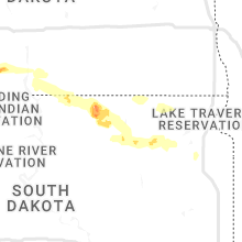
Hail Map for Friday, July 22, 2022

Number of Impacted Households on 7/22/2022
0
Impacted by 1" or Larger Hail
0
Impacted by 1.75" or Larger Hail
0
Impacted by 2.5" or Larger Hail
Square Miles of Populated Area Impacted on 7/22/2022
0
Impacted by 1" or Larger Hail
0
Impacted by 1.75" or Larger Hail
0
Impacted by 2.5" or Larger Hail


Cities Most Affected by Hail Storms of 7/22/2022
| Hail Size | Demographics of Zip Codes Affected | ||||||
|---|---|---|---|---|---|---|---|
| City | Count | Average | Largest | Pop Density | House Value | Income | Age |
| Pleasanton, NE | 1 | 1.75 | 1.75 | 5 | $74k | $40.5k | 41.6 |
Hail and Wind Damage Spotted on 7/22/2022
Filter by Report Type:Hail ReportsWind Reports
States Impacted
Pennsylvania, South Carolina, Utah, Ohio, West Virginia, Oklahoma, Mississippi, Florida, New York, Arizona, Alabama, Kansas, North Dakota, Wyoming, Nebraska, Illinois, Minnesota, Iowa, Indiana, South DakotaPennsylvania
| Local Time | Report Details |
|---|---|
| 2:04 PM EDT | Quarter sized hail reported near Trout Run, PA, 57.9 miles NE of State College, PA, quarter sized hail in trout run. |
| 2:45 PM EDT | Trees down. time estimated from rada in luzerne county PA, 12 miles W of Scranton, PA |
| 2:58 PM EDT | Several trees down... tree down on a truc in luzerne county PA, 11.6 miles SW of Scranton, PA |
| 3:45 PM EDT | Trees down. unknown size or number of trees. time estimated from rada in wyoming county PA, 25.3 miles NW of Scranton, PA |
| 4:00 PM EDT | Multiple trees down. unknown size or number of trees. time estimated from rada in wyoming county PA, 16.1 miles NW of Scranton, PA |
| 6:32 PM EDT | Trees down in the wysox... ulster and standing stone area in bradford county PA, 45.6 miles WNW of Scranton, PA |
South Carolina
| Local Time | Report Details |
|---|---|
| 3:11 PM EDT | Report of some trees and fences down... and windows broken out of a home. damage occurred on canvas back driv in horry county SC, 46.6 miles WSW of Wilmington, NC |
Utah
| Local Time | Report Details |
|---|---|
| 1:35 PM MDT | Estimate based on pictures of damage to large tree and pivot irrigatio in tooele county UT, 24.9 miles WSW of Salt Lake City, UT |
| 2:55 PM MDT | Causeway mesonet site in tooele county UT, 94.4 miles NE of Ely, NV |
| 3:15 PM MDT | V-grid mesonet site in tooele county UT, 85.4 miles WSW of Salt Lake City, UT |
| 3:30 PM MDT | Pom north side mesonet site in salt lake county UT, 20 miles S of Salt Lake City, UT |
| 3:35 PM MDT | Apg mesonet site in tooele county UT, 79.1 miles WSW of Salt Lake City, UT |
| 3:45 PM MDT | Playa station mesonet site in tooele county UT, 72.8 miles WSW of Salt Lake City, UT |
| 4:00 PM MDT | Aerie mesonet site in summit county UT, 22.2 miles ESE of Salt Lake City, UT |
| 4:00 PM MDT | Lower cedar mountain mesonet site in tooele county UT, 66.3 miles WSW of Salt Lake City, UT |
| 4:15 PM MDT | Dugway 32 mesonet site in tooele county UT, 60.4 miles SW of Salt Lake City, UT |
| 4:30 PM MDT | Johnsons pass mesonet site in tooele county UT, 46.1 miles SW of Salt Lake City, UT |
| 4:40 PM MDT | I-80 at grassey in tooele county UT, 58.9 miles W of Salt Lake City, UT |
| 4:50 PM MDT | I-80 at mp 71 - east delle in tooele county UT, 45.8 miles W of Salt Lake City, UT |
| 5:00 PM MDT | I-80 at mp 79 - timpie in tooele county UT, 37.4 miles W of Salt Lake City, UT |
| 5:20 PM MDT | I-80 mp 107 in salt lake county UT, 13.8 miles W of Salt Lake City, UT |
| 5:40 PM MDT | Legacy parkway in davis county UT, 10.5 miles N of Salt Lake City, UT |
| 5:45 PM MDT | Pom north side in salt lake county UT, 20 miles S of Salt Lake City, UT |
Ohio
| Local Time | Report Details |
|---|---|
| 3:42 PM EDT | Tree down along coffman rd. time estimated from rada in washington county OH, 72.6 miles N of Charleston, WV |
West Virginia
| Local Time | Report Details |
|---|---|
| 3:46 PM EDT | Tree down along old saint marys pike power out in the are in wood county WV, 68.5 miles N of Charleston, WV |
| 3:59 PM EDT | Trees down off of route 31 east of the airport. time estimated from rada in wood county WV, 70 miles N of Charleston, WV |
| 4:27 PM EDT | Tree into power lines along windy bush r in wood county WV, 62 miles NNE of Charleston, WV |
| 4:37 PM EDT | Trees down south of petroleum time estimated from rada in ritchie county WV, 61.3 miles NNE of Charleston, WV |
| 5:00 PM EDT | Trees down along cabin run. time estimated from rada in ritchie county WV, 60.8 miles NNE of Charleston, WV |
Oklahoma
| Local Time | Report Details |
|---|---|
| 3:45 PM CDT | Wilburton mesonet reported a 66 mph wind gus in latimer county OK, 57.6 miles NE of Atoka, OK |
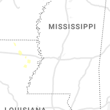
Mississippi
| Local Time | Report Details |
|---|---|
| 3:47 PM CDT | Multiple trees downed. pea sized hail reporte in lauderdale county MS, 75.8 miles S of Starkville, MS |
Florida
| Local Time | Report Details |
|---|---|
| 6:10 PM EDT | Delayed report. social media post reports one tree uprooted and another snapped in half from thunderstorm winds. exact time and location approximate in bradford county FL, 51.7 miles SW of Jacksonville, FL |
| 6:55 PM EDT | Spg airport reported 52 knots/60 mph peak wind gus in pinellas county FL, 18.5 miles N of Bradenton, FL |
| 7:38 PM EDT | Thunderstorm wind damage... possible tornado reporte in marion county FL, 46.7 miles NW of Orlando, FL |
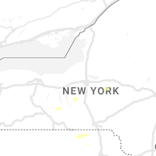
New York
| Local Time | Report Details |
|---|---|
| 6:46 PM EDT | Trees and wires down throughout northern portion of the count in cortland county NY, 23.5 miles SSE of Syracuse, NY |
| 6:53 PM EDT | A tree fell on a house on hollister stree in yates county NY, 55.6 miles SW of Syracuse, NY |
| 7:09 PM EDT | Multiple reports of trees down in deruyte in madison county NY, 23.9 miles SSE of Syracuse, NY |
| 7:27 PM EDT | A few trees down around eato in madison county NY, 31 miles ESE of Syracuse, NY |
| 7:27 PM EDT | Trees and limbs down on route 2 in madison county NY, 28.3 miles ESE of Syracuse, NY |
| 7:27 PM EDT | Tree down and blocking all lanes on ny-8 in seneca county NY, 40.2 miles SW of Syracuse, NY |
| 7:27 PM EDT | Lines and a tree down on holten beach roa in seneca county NY, 40.5 miles SW of Syracuse, NY |
| 7:27 PM EDT | Two poles down near the intersection of county road 142 and halls corners roa in seneca county NY, 43.1 miles SW of Syracuse, NY |
| 7:37 PM EDT | Tree down on preston hill roa in madison county NY, 36.1 miles ESE of Syracuse, NY |
| 7:41 PM EDT | Multiple reports of trees down along state route 90 in & near geno in cayuga county NY, 32.9 miles SW of Syracuse, NY |
| 8:45 PM EDT | Trees down near intersection of castle rd and state route 28 in herkimer county NY, 58.3 miles WNW of Schenectady, NY |
| 8:55 PM EDT | Approximately 30 trees down at a residence on dairy hill rd. time estimated from radar in herkimer county NY, 52.7 miles WNW of Schenectady, NY |
Arizona
| Local Time | Report Details |
|---|---|
| 3:52 PM MST | Quarter sized hail reported near Patagonia, AZ, 48.7 miles SSE of Tucson, AZ, hail reported 1in estimated still ongoing. |
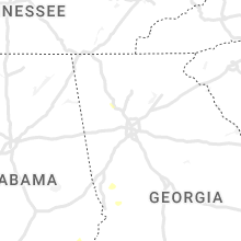
Alabama
| Local Time | Report Details |
|---|---|
| 6:22 PM CDT | A few trees were blown dow in shelby county AL, 19.3 miles S of Birmingham, AL |
Kansas
| Local Time | Report Details |
|---|---|
| 6:28 PM CDT | Storm damage reported in wichita county KS, 52.8 miles SSW of Colby, KS |
| 6:57 PM CDT | Storm damage reported in decatur county KS, 27.2 miles NE of Colby, KS |
| 7:14 PM CDT | Storm damage reported in rawlins county KS, 23.5 miles NNE of Colby, KS |
| 7:35 PM CDT | Corrects previous tstm wnd gst report from 2 e leoti. kansas mesonet. 61 mph gust at 10 meter height... 45 mph gust at 2 meter heigh in wichita county KS, 43.7 miles NW of Garden City, KS |
| 7:38 PM CDT | Storm damage reported in sheridan county KS, 25.9 miles ENE of Colby, KS |
| 7:39 PM CDT | Quarter sized hail reported near Selden, KS, 28 miles ENE of Colby, KS, trained spotter reported hail about the size of quarters... some were slightly larger than quarters. winds near 50 mph were also estimated. |
| 7:45 PM CDT | Delayed report from trained spotter. time (+/- 15 minutes) and magnitude are estimate in sheridan county KS, 33 miles E of Colby, KS |
| 7:50 PM CDT | Spotter estimated wind gusts ranging 60-70mph. time estimate in sheridan county KS, 32.4 miles E of Colby, KS |
| 8:01 PM CDT | Kansas mesonet. 61 mph gust at 10 meter height... 45 mph gust at 2 meter heigh in wichita county KS, 43.7 miles NW of Garden City, KS |
| 8:14 PM CDT | Storm damage reported in sheridan county KS, 33.4 miles ESE of Colby, KS |
| 8:28 PM CDT | Quarter sized hail reported near Oakley, KS, 35.2 miles SSE of Colby, KS, off-duty nws employee reports at least quarter-size hail. location estimated. |
| 8:28 PM CDT | Off-duty nws employee reports wind gusts of at least 70mph. location estimate in logan county KS, 35.2 miles SSE of Colby, KS |
| 8:28 PM CDT | Corrects previous tstm wnd gst report from 11 nnw the monument rocks. off-duty nws employee reports wind gusts of at least 70mph. location estimated. correction: employ in logan county KS, 38.5 miles SSE of Colby, KS |
| 8:28 PM CDT | Ping Pong Ball sized hail reported near Oakley, KS, 38.5 miles SSE of Colby, KS, corrects previous hail report from 11 nnw the monument rocks. off-duty nws employee reports at least quarter-size hail. location estimated. correction: employee called |
| 8:46 PM CDT | Lawn furniture thrown... 6 inch tree limb damaged. delayed report via social medi in graham county KS, 43.4 miles NW of Hays, KS |
| 8:49 PM CDT | Storm damage reported in graham county KS, 44.1 miles NW of Hays, KS |
| 8:55 PM CDT | Videos sent in via social media showing multiple... healthy tree branches broken off due to thunderstorm winds. branches look to be about 4 inches in diameter. time and in graham county KS, 47.1 miles NW of Hays, KS |
| 9:54 PM CDT | Storm damage reported in rooks county KS, 24.8 miles N of Hays, KS |
| 10:29 PM CDT | Awos station khys hays regional airport awos sit in ellis county KS, 3.7 miles ESE of Hays, KS |
| 10:40 PM CDT | Awos station khys hays regional airport awos sit in ellis county KS, 3.7 miles ESE of Hays, KS |
North Dakota
| Local Time | Report Details |
|---|---|
| 8:09 PM CDT | Quarter sized hail reported near Tolley, ND, 47.7 miles NNW of Minot, ND |
| 8:18 PM CDT | Storm damage reported in renville county ND, 47.7 miles NNW of Minot, ND |
| 8:27 PM CDT | Ping Pong Ball sized hail reported near Mohall, ND, 43.7 miles NNW of Minot, ND |
| 8:29 PM CDT | Corrects previous tstm wnd gst report from 4 w mohall. us air force weather statio in renville county ND, 38.6 miles NNW of Minot, ND |
| 8:30 PM CDT | Facebook report of a damaged quonset farm buildin in bottineau county ND, 27.5 miles N of Minot, ND |
| 8:38 PM CDT | Quarter sized hail was also reporte in renville county ND, 32.9 miles NNW of Minot, ND |
| 8:59 PM CDT | Minot af in ward county ND, 12.8 miles N of Minot, ND |
| 8:59 PM CDT | Dime sized hail also reporte in bottineau county ND, 27.5 miles N of Minot, ND |
| 9:00 PM CDT | Quarter sized hail reported near Minot AFB, ND, 12.8 miles N of Minot, ND |
| 9:00 PM CDT | Facebook report of tree and roof damage at the minot air force bas in ward county ND, 13 miles NNW of Minot, ND |
| 9:06 PM CDT | Pea sized hail also reporte in bottineau county ND, 25.2 miles N of Minot, ND |
| 9:45 PM CDT | Half Dollar sized hail reported near Granville, ND, 21.8 miles E of Minot, ND |
| 9:51 PM CDT | Ndawn site reported wind gus in mchenry county ND, 32.3 miles ESE of Minot, ND |
| 10:15 PM CDT | Loss of powe in mchenry county ND, 51.5 miles ESE of Minot, ND |
| 10:15 PM CDT | From ndawn sit in pierce county ND, 44.2 miles NW of Devils Lake, ND |
| 10:15 PM CDT | Ping Pong Ball sized hail reported near Anamoose, ND, 51.1 miles ESE of Minot, ND |
| 10:42 PM CDT | Ndawn niles station reports 79 mph gust at 10 meter in benson county ND, 24.2 miles WNW of Devils Lake, ND |
| 10:45 PM CDT | Ndawn reports 62 mph gust at 10 meter in benson county ND, 32.3 miles WSW of Devils Lake, ND |
| 11:03 PM CDT | Us air force weather statio in renville county ND, 38.6 miles NNW of Minot, ND |
| 11:04 PM CDT | Ndawn station reports 60 mph wind gus in ramsey county ND, 13.7 miles N of Devils Lake, ND |
| 11:19 PM CDT | Devils lake awos reports 61 mp in ramsey county ND, 2.9 miles W of Devils Lake, ND |
| 11:29 PM CDT | Report from the devils lake rwi in ramsey county ND, 4.4 miles SW of Devils Lake, ND |
| 11:45 PM CDT | Ndawn repor in ramsey county ND, 25.3 miles ENE of Devils Lake, ND |
| 11:48 PM CDT | Gust at 10 meters courtesy of ndaw in nelson county ND, 33.2 miles SE of Devils Lake, ND |
| 12:01 AM CDT | Personal weather station reports 58 mp in nelson county ND, 34.1 miles E of Devils Lake, ND |
| 12:18 AM CDT | Ndawn reports 65 mph at 10 meter in grand forks county ND, 51.9 miles ESE of Devils Lake, ND |
| 12:26 AM CDT | Ndawn repor in grand forks county ND, 53.6 miles ESE of Devils Lake, ND |
| 12:30 AM CDT | Measured at personal weather statio in grand forks county ND, 55 miles ESE of Devils Lake, ND |
| 12:44 AM CDT | Quarter sized hail reported near Northwood, ND, 67.2 miles NNW of Fargo, ND, report from mping: quarter (1.00 in.). |
| 12:45 AM CDT | Report from mping: 3-inch tree limbs broken; power poles broke in grand forks county ND, 67.2 miles NNW of Fargo, ND |
| 12:45 AM CDT | Storm damage reported in grand forks county ND, 71.1 miles ESE of Devils Lake, ND |
| 12:47 AM CDT | Three downed tree in grand forks county ND, 64.9 miles N of Fargo, ND |
| 12:47 AM CDT | 250 to 300 foot swath of large... old growth trees in shelter belt ripped apart. large 6-12 inch diameter trees ripped. sent deer running into the stor in grand forks county ND, 65 miles NNW of Fargo, ND |
| 12:51 AM CDT | Ndawn reports a gust of 70 mph at 10 meter in grand forks county ND, 72.5 miles E of Devils Lake, ND |
| 1:05 AM CDT | Measured at dot statio in grand forks county ND, 77.1 miles NNW of Fargo, ND |
| 1:06 AM CDT | Storm damage reported in grand forks county ND, 74.5 miles NNW of Fargo, ND |
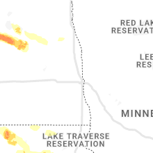
Wyoming
| Local Time | Report Details |
|---|---|
| 7:16 PM MDT | I-80 and us-189 - first divide in uinta county WY, 67.3 miles ENE of Salt Lake City, UT |
Nebraska
| Local Time | Report Details |
|---|---|
| 10:34 PM CDT | Golf Ball sized hail reported near Pleasanton, NE, 50.3 miles W of Grand Island, NE, delayed report. facebook photo of large hail estimated to be just shy of hen egg size. location estimated based on description of 13 s of mason city. time estimated fro |
| 1:14 AM CDT | Quarter sized hail reported near Gibbon, NE, 28 miles WSW of Grand Island, NE |
| 1:29 AM CDT | Nebraska dot mesonet along interstate 80 at shelton exi in buffalo county NE, 25.3 miles SW of Grand Island, NE |
| 1:44 AM CDT | Quarter sized hail reported near Kenesaw, NE, 26.9 miles SW of Grand Island, NE, facebook report. |
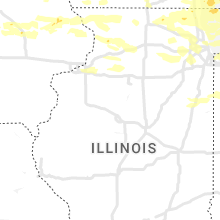
Illinois
| Local Time | Report Details |
|---|---|
| 1:14 AM CDT | Half Dollar sized hail reported near Mchenry, IL, 42.4 miles NW of Chicago, IL, measured size... with photo received on twitter. |
| 1:45 AM CDT | Quarter sized hail reported near Waukegan, IL, 34.6 miles NNW of Chicago, IL, photo received via twitter. |
| 4:10 AM CDT | Quarter sized hail reported near Freeport, IL, 52.8 miles SSW of Madison, WI, occurring right now. |
| 4:18 AM CDT | Peak thunderstorm wind gust at ohare airpor in cook county IL, 15.3 miles WNW of Chicago, IL |
| 5:18 AM CDT | Correction to time. peak thunderstorm wind gust at ohare airpor in cook county IL, 15.3 miles WNW of Chicago, IL |
Minnesota
| Local Time | Report Details |
|---|---|
| 1:15 AM CDT | Storm damage reported in polk county MN, 62.3 miles N of Fargo, ND |
| 1:18 AM CDT | Measured at personal weather statio in polk county MN, 65.7 miles N of Fargo, ND |
| 1:25 AM CDT | Measured at dot statio in polk county MN, 69.6 miles N of Fargo, ND |
| 1:36 AM CDT | Measured at personal weather statio in polk county MN, 67.3 miles N of Fargo, ND |
| 3:06 AM CDT | Measured by raws sit in beltrami county MN, 0.5 miles N of Bemidji, MN |
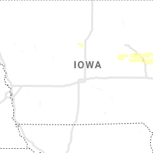
Iowa
| Local Time | Report Details |
|---|---|
| 3:07 AM CDT | Storm damage reported in dubuque county IA, 57 miles ENE of Cedar Rapids, IA |
| 4:02 AM CDT | Iadot rwi in clinton county IA, 57.8 miles E of Cedar Rapids, IA |
| 4:21 AM CDT | Tree reported to be blown down in rock creek campgroun in clinton county IA, 71.6 miles ESE of Cedar Rapids, IA |
Indiana
| Local Time | Report Details |
|---|---|
| 4:45 AM EDT | Quarter sized hail reported near Pleasant Lake, IN, 37 miles N of Fort Wayne, IN, report from mping: quarter (1.00 in.). |
| 6:15 AM CDT | Quarter sized hail reported near Walkerton, IN, 68 miles ESE of Chicago, IL, report from mping: quarter (1.00 in.). |
| 7:28 AM EDT | 5 inch diameter limb approx. 20 feet long down. several smaller branches down as wel in elkhart county IN, 59.7 miles NW of Fort Wayne, IN |
| 7:29 AM EDT | Quarter sized hail reported near Plymouth, IN, 70 miles WNW of Fort Wayne, IN, report from mping: quarter (1.00 in.). |
South Dakota
| Local Time | Report Details |
|---|---|
| 5:30 AM CDT | Mesonet station 50 herreid (sddot in campbell county SD, 73 miles SSE of Bismarck, ND |
| 6:15 AM CDT | Storm damage reported in edmunds county SD, 41.9 miles WNW of Aberdeen, SD |
Connect with Interactive Hail Maps