

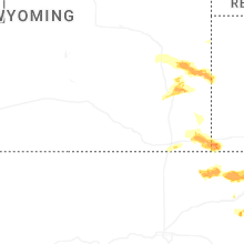
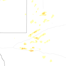
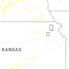
Hail Map for Monday, June 2, 2025

Number of Impacted Households on 6/2/2025
0
Impacted by 1" or Larger Hail
0
Impacted by 1.75" or Larger Hail
0
Impacted by 2.5" or Larger Hail
Square Miles of Populated Area Impacted on 6/2/2025
0
Impacted by 1" or Larger Hail
0
Impacted by 1.75" or Larger Hail
0
Impacted by 2.5" or Larger Hail


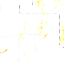

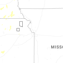

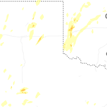
Cities Most Affected by Hail Storms of 6/2/2025
| Hail Size | Demographics of Zip Codes Affected | ||||||
|---|---|---|---|---|---|---|---|
| City | Count | Average | Largest | Pop Density | House Value | Income | Age |
| Sterling, CO | 1 | 2.00 | 2.00 | 31 | $91k | $32.2k | 37.3 |
| Merino, CO | 1 | 2.00 | 2.00 | 3 | $90k | $36.2k | 40.8 |
| North Platte, NE | 1 | 1.75 | 1.75 | 50 | $79k | $36.3k | 38.7 |
| Elk Point, SD | 1 | 1.75 | 1.75 | 15 | $82k | $41.4k | 39.5 |
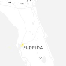
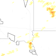
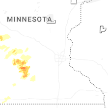
Hail and Wind Damage Spotted on 6/2/2025
Filter by Report Type:Hail ReportsWind Reports
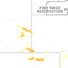
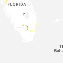
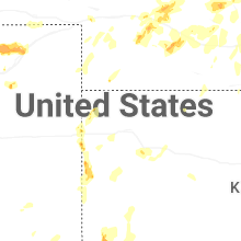
States Impacted
Florida, Texas, Minnesota, New Mexico, Iowa, Kansas, Oklahoma, Wyoming, South Dakota, Colorado, NebraskaFlorida
| Local Time | Report Details |
|---|---|
| 10:56 AM EDT | Report from davis island yacht clu in hillsborough county FL, 29.6 miles NNE of Bradenton, FL |
| 11:10 AM EDT | Quarter sized hail reported near Tampa, FL, 35.9 miles NNE of Bradenton, FL, a few reports of quarter size hail near the florida state fairgrounds. |
| 11:12 AM EDT | Ping Pong Ball sized hail reported near Tampa, FL, 37.2 miles NNE of Bradenton, FL, report of 1.5-inch hail near intersection of i-4 and hwy 301. |
Texas
| Local Time | Report Details |
|---|---|
| 1:42 PM CDT | Corrects previous non-tstm wnd gst report from 11 wnw bootle in deaf smith county TX, 46.2 miles ESE of Tucumcari, NM |
| 2:21 PM CDT | West texas mesone in oldham county TX, 52.5 miles W of Amarillo, TX |
| 2:46 PM CDT | Peak gust from west texas mesonet. severe gusts from 2:45 to 2:48 pm cd in castro county TX, 51 miles SSW of Amarillo, TX |
| 3:16 PM CDT | West texas mesonet report. additional 58 mph gust also occurred at 3:20 pm cd in swisher county TX, 46.3 miles S of Amarillo, TX |
| 3:23 PM CDT | Storm damage reported in hartley county TX, 69 miles NW of Amarillo, TX |
| 3:26 PM CDT | West texas mesonet repor in swisher county TX, 32.2 miles S of Amarillo, TX |
| 3:26 PM CDT | Storm damage reported in randall county TX, 16.8 miles SSW of Amarillo, TX |
| 3:30 PM CDT | Storm damage reported in lubbock county TX, 5.7 miles NNE of Lubbock, TX |
| 3:34 PM CDT | Multiple severe gusts of 59 to 63 mph starting around 3:25 pm and continuing through 3:35 p in hartley county TX, 69.1 miles NW of Amarillo, TX |
| 3:41 PM CDT | Storm damage reported in randall county TX, 20.5 miles SW of Amarillo, TX |
| 3:44 PM CDT | West texas mesonet repor in hale county TX, 20.6 miles NNE of Lubbock, TX |
| 3:44 PM CDT | Tree and roof damage reported from severe thunderstorm outflow wind gust in lubbock county TX, 11.2 miles ENE of Lubbock, TX |
| 3:46 PM CDT | Storm damage reported in sherman county TX, 81.2 miles NNW of Amarillo, TX |
| 3:55 PM CDT | Multiple 1 inch diameter... and slightly larger tree branches snappe in hutchinson county TX, 35.9 miles NNE of Amarillo, TX |
| 5:33 PM CDT | Storm damage reported in hemphill county TX, 77.6 miles SW of Woodward, OK |
| 5:58 PM CDT | Also up to nickel-sized hai in hockley county TX, 20.5 miles WSW of Lubbock, TX |
| 5:59 PM CDT | Storm damage reported in hockley county TX, 18.1 miles W of Lubbock, TX |
| 6:42 PM CDT | Corrects previous tstm wnd dmg report from fort stockton. approximately 50 homes had minor roof damage and 20 power poles were broken due to severe winds and hail in th in pecos county TX, 58.9 miles NE of Alpine, TX |
| 6:43 PM CDT | Report of a fence and backyard antenna tower blown over. time estimated by rada in pecos county TX, 58.9 miles NE of Alpine, TX |
| 7:28 PM CDT | Storm damage reported in lynn county TX, 26.7 miles S of Lubbock, TX |
| 7:31 PM CDT | Half Dollar sized hail reported near Tahoka, TX, 29.3 miles S of Lubbock, TX, media viewer reported. |
| 9:20 PM CDT | Fence blown down by thunderstorm wind in gaines county TX, 68.1 miles NNW of Odessa, TX |
| 11:45 PM CDT | Asos station kama amarillo (asos in potter county TX, 6.5 miles E of Amarillo, TX |
| 12:17 AM CDT | 61 mph thunderstorm wind gust reported by mesonet station 25 in seminol in gaines county TX, 63.3 miles NNW of Odessa, TX |
| 2:12 AM CDT | 1 mobile home damaged... another destroyed. power out in the are in ector county TX, 8.9 miles S of Odessa, TX |
| 2:12 AM CDT | Ping Pong Ball sized hail reported near Odessa, TX, 8.9 miles S of Odessa, TX |
| 2:18 AM CDT | Ping Pong Ball sized hail reported near Odessa, TX, 10.6 miles SSE of Odessa, TX, report from mping: ping pong ball (1.50 in.). |
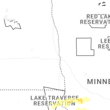
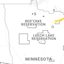
Minnesota
| Local Time | Report Details |
|---|---|
| 1:46 PM CDT | Ndawn observatio in grant county MN, 64.1 miles NNW of Montevideo, MN |
| 1:47 PM CDT | Ndawn observation sit in grant county MN, 64.1 miles NNW of Montevideo, MN |
| 1:55 PM CDT | Ten to 16 inch diameter trees and various limbs snapped off at a residence north of morris along hwy 59. time estimated based on rada in stevens county MN, 46.3 miles N of Montevideo, MN |
| 2:10 PM CDT | Storm damage reported in grant county MN, 66.7 miles N of Montevideo, MN |
| 2:13 PM CDT | 61 mph gust measured with personal weather statio in swift county MN, 23.3 miles NNW of Montevideo, MN |
| 2:20 PM CDT | Trees and power lines reported down in starbuck. time estimated based on rada in pope county MN, 46.4 miles NNE of Montevideo, MN |
| 2:30 PM CDT | Measured at alexandria airpor in douglas county MN, 64.7 miles NNE of Montevideo, MN |
| 2:30 PM CDT | Trees and power lines reported down in glenwood. time estimated based on rada in pope county MN, 50.8 miles NNE of Montevideo, MN |
| 2:30 PM CDT | Several trees down... including one on a farm building. time estimated based on rada in douglas county MN, 62.7 miles NNE of Montevideo, MN |
| 2:35 PM CDT | Several trees down... including one on a trailer. time estimated based on rada in pope county MN, 56.5 miles NNE of Montevideo, MN |
| 2:40 PM CDT | Measured by mndot rwis along hwy in swift county MN, 30.9 miles NNE of Montevideo, MN |
| 2:45 PM CDT | Wind gust estimated 55 to 60 mph... scouring dirt from the fields creating near zero visibility for a brief tim in otter tail county MN, 84.3 miles SE of Fargo, ND |
| 4:59 PM CDT | Report of damage to a metal outbuildin in kandiyohi county MN, 25.9 miles E of Montevideo, MN |
| 5:11 PM CDT | Half Dollar sized hail reported near Olivia, MN, 37.6 miles ESE of Montevideo, MN, delayed report... time estimated from radar. half dollar sized hail near cr11 north of olivia. |
| 5:12 PM CDT | Half Dollar sized hail reported near Olivia, MN, 38.1 miles ESE of Montevideo, MN |
| 5:41 PM CDT | A few birch trees were downed from southwest to northeast and on the shoulder of us in itasca county MN, 67.9 miles WNW of Duluth, MN |
| 6:33 PM CDT | Several downed trees near the new ulm medical center. time estimated from rada in brown county MN, 75.4 miles SE of Montevideo, MN |
| 6:34 PM CDT | Several large trees snapped at their base in german park. time estimated from rada in brown county MN, 74.4 miles SW of Minneapolis, MN |
| 6:34 PM CDT | A dead... 2 foot diameter tree downed along 5th north street. time estimated from rada in brown county MN, 74.8 miles SW of Minneapolis, MN |
| 6:35 PM CDT | Awos station kulm new ulm a in brown county MN, 74.2 miles SE of Montevideo, MN |
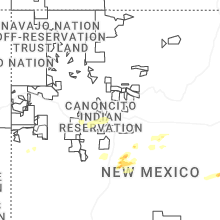
New Mexico
| Local Time | Report Details |
|---|---|
| 1:01 PM MDT | Awos station kcvs cannon air force bas in curry county NM, 60.3 miles SSE of Tucumcari, NM |
| 1:06 PM MDT | Awos station kcvs cannon air force bas in curry county NM, 60.3 miles SSE of Tucumcari, NM |
| 1:08 PM MDT | Mesonet station gw0819 clovi in curry county NM, 57.8 miles SSE of Tucumcari, NM |
| 1:13 PM MDT | Mesonet station gw0819 clovi in curry county NM, 57.8 miles SSE of Tucumcari, NM |
| 5:07 PM MDT | Power lines down at mile markers 53-55 on highway 128 east of jal. time estimated by rada in lea county NM, 49.5 miles WNW of Odessa, TX |
Iowa
| Local Time | Report Details |
|---|---|
| 4:12 PM CDT | Ping Pong Ball sized hail reported near Sioux Center, IA, 37.4 miles SE of Sioux Falls, SD, half dollar to ping pong size hail. |
| 4:16 PM CDT | Quarter sized hail reported near Sioux Center, IA, 37.4 miles SE of Sioux Falls, SD, report from mping: quarter (1.00 in.). |
| 5:05 PM CDT | Half Dollar sized hail reported near Doon, IA, 30.8 miles SE of Sioux Falls, SD, yard is covered with various sizes of hail... many with flat tops from the briefly heavy rain. |
| 5:20 PM CDT | Quarter sized hail reported near Rock Rapids, IA, 31.5 miles ESE of Sioux Falls, SD, hail from dime to quarter size. |
| 6:39 PM CDT | Wind destroyed a hog barn with debris on highway 6 in sioux county IA, 47.3 miles NW of Storm Lake, IA |
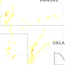
Kansas
| Local Time | Report Details |
|---|---|
| 4:28 PM CDT | Quarter sized hail reported near Rolla, KS, 72.9 miles SSW of Garden City, KS |
| 5:15 PM CDT | Awos station keha elkhart awos sit in morton county KS, 87.5 miles SW of Garden City, KS |
| 5:30 PM CDT | Storm damage reported in seward county KS, 64.7 miles S of Garden City, KS |
| 5:17 PM MDT | Nw_tribune_ks_(awn67d228aaf1137615aff5a604 in greeley county KS, 71.4 miles NW of Garden City, KS |
| 6:27 PM CDT | Report received from awn casade rodney observation sit in finney county KS, 6.5 miles WNW of Garden City, KS |
| 5:36 PM MDT | Weather link site section 32 reports 71 mph wind gus in wallace county KS, 66.3 miles SW of Colby, KS |
| 5:44 PM MDT | Weather link site farm location reports 59 mph wind gus in wallace county KS, 66.2 miles SW of Colby, KS |
| 5:49 PM MDT | Ks-wallac in wallace county KS, 58.8 miles SW of Colby, KS |
| 5:53 PM MDT | Awn site section 22 reports 64 mph wind gus in wallace county KS, 63.7 miles SW of Colby, KS |
| 5:54 PM MDT | Storm damage reported in wallace county KS, 51.6 miles SW of Colby, KS |
| 7:19 PM CDT | Asos station kddc dodge city regional airpor in ford county KS, 51.2 miles ESE of Garden City, KS |
| 6:19 PM MDT | Kgld reports 74 mph wind gus in sherman county KS, 35.1 miles W of Colby, KS |
| 6:19 PM MDT | Weather link site rietcheck farms reports 79 mph wind gus in sherman county KS, 39.4 miles W of Colby, KS |
| 7:23 PM CDT | Awn site cm_kistler reports 58 mph wind gus in thomas county KS, 11.8 miles SSW of Colby, KS |
| 6:28 PM MDT | Downed limbs along the 900 block of broadwa in sherman county KS, 35.8 miles W of Colby, KS |
| 6:30 PM MDT | Camper tipped over on i-70 mm 2 in sherman county KS, 28 miles W of Colby, KS |
| 6:30 PM MDT | Report of numerous blow overs from mm 32 east to mm 36 on i-7 in sherman county KS, 22.2 miles WSW of Colby, KS |
| 7:46 PM CDT | Koel reports 67 mph wind gust with half mile visibilit in logan county KS, 23.2 miles SSE of Colby, KS |
| 7:47 PM CDT | Awn site 1730 rd q reports 62 mph wind gus in cheyenne county KS, 46.4 miles NW of Colby, KS |
| 7:50 PM CDT | Trained spotter estimates 60-70 mph wind gus in cheyenne county KS, 40 miles NW of Colby, KS |
| 7:58 PM CDT | Two inch diameter tree limb blown dow in cheyenne county KS, 47.8 miles WNW of Colby, KS |
| 7:59 PM CDT | Awn site 3350 reports 62 mph wind gus in cheyenne county KS, 40.6 miles NNW of Colby, KS |
| 8:10 PM CDT | Ksyf reports wind gust of 61 mp in cheyenne county KS, 47.4 miles WNW of Colby, KS |
| 8:15 PM CDT | Awos station ksyf st. francis cit in cheyenne county KS, 47.8 miles WNW of Colby, KS |
| 8:25 PM CDT | Kzlf transmitter sit in barber county KS, 56.4 miles NE of Woodward, OK |
| 8:25 PM CDT | Report of 60 mph winds between 8:15-8:30 pm l in rawlins county KS, 30.9 miles N of Colby, KS |
| 8:29 PM CDT | Trained spotter reports winds around 40 with gusts to 60 mp in sheridan county KS, 33.4 miles E of Colby, KS |
| 8:35 PM CDT | Awos station koin oberli in decatur county KS, 40.6 miles NE of Colby, KS |
| 9:14 PM CDT | Pws site kksselde20 reports 58 mph wind gus in sheridan county KS, 27.7 miles ENE of Colby, KS |
| 9:27 PM CDT | Awn site selden reports 61 mph wind gus in sheridan county KS, 27.7 miles ENE of Colby, KS |
| 9:55 PM CDT | Awos station koin oberlin decaying showers in the are in decatur county KS, 40.6 miles NE of Colby, KS |
| 4:38 AM CDT | Delayed report... courtesy of ksu mesone in reno county KS, 41.5 miles WNW of Wichita, KS |
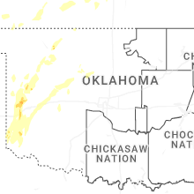
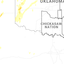
Oklahoma
| Local Time | Report Details |
|---|---|
| 4:35 PM CDT | Storm damage reported in cimarron county OK, 108.8 miles NNW of Amarillo, TX |
| 6:41 PM CDT | Quarter sized hail reported near Mangum, OK, 50.2 miles NE of Childress, TX, report from mping: quarter (1.00 in.). |
| 7:15 PM CDT | Storm damage reported in beckham county OK, 76.1 miles S of Woodward, OK |
| 7:31 PM CDT | Half Dollar sized hail reported near Canute, OK, 79.1 miles S of Woodward, OK, report from mping: half dollar (1.25 in.). |
| 7:33 PM CDT | Storm damage reported in washita county OK, 75.5 miles S of Woodward, OK |
| 7:35 PM CDT | Trees uprooted. mping report. time estimated from rada in washita county OK, 75.8 miles S of Woodward, OK |
| 8:52 PM CDT | Storm damage reported in roger mills county OK, 58.8 miles SSW of Woodward, OK |
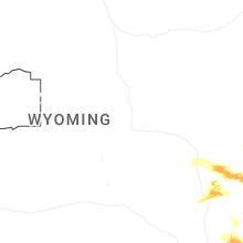
Wyoming
| Local Time | Report Details |
|---|---|
| 3:51 PM MDT | Quarter sized hail reported near Cheyenne, WY, 44.7 miles ESE of Laramie, WY, report of quarter size hail. |
| 3:52 PM MDT | Wydot sensor at coleman on interstate 25 measured a wind gust of 59 mp in platte county WY, 74.8 miles ESE of Casper, WY |
| 4:09 PM MDT | Camp guernsey airport gust 64 mp in platte county WY, 61.4 miles WNW of Scottsbluff, NE |
| 4:27 PM MDT | Quarter sized hail reported near Guernsey, WY, 59.5 miles WNW of Scottsbluff, NE, picture on social media showing quarter size hail. |
| 4:48 PM MDT | Half Dollar sized hail reported near Burns, WY, 58.2 miles SW of Scottsbluff, NE, picture on social media showing half dollar size hail. |
| 5:15 PM MDT | Half Dollar sized hail reported near Burns, WY, 58.2 miles SW of Scottsbluff, NE, report from mping: half dollar (1.25 in.). |
| 5:27 PM MDT | Emergency manager reports down trees and power outages around torringto in goshen county WY, 30.3 miles WNW of Scottsbluff, NE |
| 8:37 PM MDT | Em shared picture in slack of a newer-build barn with the roof ripped off and laying on the camper next to i in goshen county WY, 33 miles WNW of Scottsbluff, NE |
South Dakota
| Local Time | Report Details |
|---|---|
| 5:20 PM CDT | Several large trees limbs down along with one large tree leaning on a house. winds estimated at least 60 mp in clay county SD, 53.9 miles SSW of Sioux Falls, SD |
| 5:21 PM CDT | Storage building destroyed by severe winds. 2.4 inches of rainfall in 15 to 20 minutes. pea to dime sized hai in clay county SD, 53.2 miles SSW of Sioux Falls, SD |
| 5:21 PM CDT | Quarter sized hail reported near Vermillion, SD, 53.7 miles S of Sioux Falls, SD |
| 5:22 PM CDT | Quarter sized hail reported near Vermillion, SD, 53.1 miles S of Sioux Falls, SD, report via social media. |
| 5:54 PM CDT | Tree and structure damage to an agricultural themed event venue. fence at property also blown over. additional damage 1 mile southeast of property on burbank road to ne in union county SD, 56.4 miles S of Sioux Falls, SD |
| 6:00 PM CDT | Large trees down across burbank roa in union county SD, 58.4 miles S of Sioux Falls, SD |
| 6:10 PM CDT | Golf Ball sized hail reported near Elk Point, SD, 57 miles S of Sioux Falls, SD, ping pong to golf ball size hail between mile markers 19 and 22 on interstate 29. a semi truck ran into another semi truck in the adjoining lane due to poor visibility |
| 6:15 PM CDT | Ping Pong Ball sized hail reported near Elk Point, SD, 59.1 miles S of Sioux Falls, SD, quarter to ping pong ball size hail. |
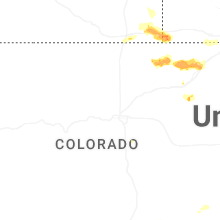
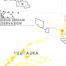
Colorado
| Local Time | Report Details |
|---|---|
| 4:24 PM MDT | Reported from kspd aso in baca county CO, 106.7 miles WSW of Garden City, KS |
| 4:26 PM MDT | Asos station kspd 8 s springfiel in baca county CO, 107 miles WSW of Garden City, KS |
| 4:59 PM MDT | Mesonet station ucnc2 ute canyo in baca county CO, 115.1 miles WSW of Garden City, KS |
| 6:47 PM MDT | Quarter sized hail reported near New Raymer, CO, 63.3 miles NW of Yuma, CO |
| 6:55 PM MDT | Half Dollar sized hail reported near Stoneham, CO, 63 miles WNW of Yuma, CO, highway completely covered by hail. |
| 7:20 PM MDT | Hen Egg sized hail reported near Merino, CO, 56.1 miles NW of Yuma, CO |
| 7:41 PM MDT | Hen Egg sized hail reported near Sterling, CO, 46.3 miles NW of Yuma, CO |
| 8:00 PM MDT | Ping Pong Ball sized hail reported near Sterling, CO, 43.7 miles NW of Yuma, CO |
| 8:06 PM MDT | Mesonet station co035 i-76 sterlin in logan county CO, 41.9 miles NW of Yuma, CO |
Nebraska
| Local Time | Report Details |
|---|---|
| 6:25 PM CDT | Storm damage reported in custer county NE, 61.4 miles ENE of North Platte, NE |
| 6:31 PM CDT | Pws peak wind gus in dixon county NE, 67.3 miles S of Sioux Falls, SD |
| 6:34 PM CDT | Quarter sized hail reported near North Platte, NE, 0.6 miles SW of North Platte, NE |
| 6:34 PM CDT | Golf Ball sized hail reported near North Platte, NE, 0.6 miles SW of North Platte, NE |
| 5:39 PM MDT | Ping Pong Ball sized hail reported near Bushnell, NE, 55.2 miles SSW of Scottsbluff, NE, trained spotter reports ping pong ball size hail. |
| 6:39 PM CDT | Ping Pong Ball sized hail reported near Sargent, NE, 70.5 miles ENE of North Platte, NE |
| 6:48 PM CDT | Quarter sized hail reported near North Platte, NE, 0.6 miles SW of North Platte, NE, photo of several 1 inch hail stones and report of minor street flooding 638 to 648pm cdt. |
| 7:03 PM CDT | Quarter sized hail reported near Ponca, NE, 70.3 miles S of Sioux Falls, SD, in addition to quarter sized hail... 60-70 mph estimated winds blew over the rain gauge and broke some sticks. rainfall was at least 1 inch. |
| 7:10 PM MDT | Tree uprooted and fallen on a house in tow in dundy county NE, 51.9 miles NNW of Colby, KS |
| 8:11 PM CDT | Awn site lorens farm reports 64 mph wind gus in hitchcock county NE, 44.8 miles NNW of Colby, KS |
| 7:16 PM MDT | Awn site ellis reports 58 mph wind gus in dundy county NE, 58.5 miles NNW of Colby, KS |
| 8:18 PM CDT | Lorens farm awn 64 mph gus in hitchcock county NE, 44.8 miles NNW of Colby, KS |
| 7:24 PM MDT | Weather link site parman reports 62 mph wind gus in dundy county NE, 61.5 miles E of Yuma, CO |
| 7:40 PM MDT | Storm damage reported in chase county NE, 62.3 miles SW of North Platte, NE |
| 9:40 PM CDT | Personal weather station gust to 64mp in harlan county NE, 80.2 miles SW of Grand Island, NE |
| 9:54 PM CDT | Personal weather station gust to 63mp in phelps county NE, 70 miles WSW of Grand Island, NE |
| 9:56 PM CDT | Personal weather station gust to 64mp in phelps county NE, 67.3 miles WSW of Grand Island, NE |
| 10:00 PM CDT | Personal weather station gust to 63mp in phelps county NE, 72.2 miles SE of North Platte, NE |
| 10:02 PM CDT | Awos reports gust to 61mp in phelps county NE, 61.9 miles WSW of Grand Island, NE |
| 10:12 PM CDT | Personal weather station gust to 58mp in phelps county NE, 53 miles WSW of Grand Island, NE |
| 10:27 PM CDT | Corrects previous tstm wnd gst report from 3 nne kearney. personal weather station reports gust to 63mp in buffalo county NE, 39.8 miles WSW of Grand Island, NE |
| 10:27 PM CDT | Photo on social media of tree damage in kearne in buffalo county NE, 41.5 miles WSW of Grand Island, NE |
| 10:27 PM CDT | Photo on social media of tree damage in kearne in buffalo county NE, 42 miles WSW of Grand Island, NE |
| 10:27 PM CDT | Photo on social media of tree damage in kearne in buffalo county NE, 42 miles WSW of Grand Island, NE |
| 10:28 PM CDT | Personal weather station gust to 62mp in buffalo county NE, 40.6 miles WSW of Grand Island, NE |
| 10:29 PM CDT | Personal weather station gust to 65mp in buffalo county NE, 38.6 miles WSW of Grand Island, NE |
| 10:32 PM CDT | Personal weather station gust to 58mp in kearney county NE, 34.8 miles SW of Grand Island, NE |
| 10:33 PM CDT | Personal weather station gust to 66mp in buffalo county NE, 41.4 miles WSW of Grand Island, NE |
| 10:34 PM CDT | Personal weather station reports gust to 72mp in kearney county NE, 32.8 miles SW of Grand Island, NE |
| 10:35 PM CDT | Personal weather station reports gust to 63mp in buffalo county NE, 39.8 miles WSW of Grand Island, NE |
| 10:40 PM CDT | Fire chief reports power poles down in kennesa in adams county NE, 26.9 miles SW of Grand Island, NE |
| 10:52 PM CDT | Personal weather station reports gust to 73mp in hall county NE, 18.8 miles WSW of Grand Island, NE |
| 10:54 PM CDT | Personal weather station reports gust to 64mp in buffalo county NE, 26.9 miles SW of Grand Island, NE |
Connect with Interactive Hail Maps