

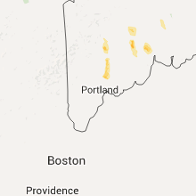
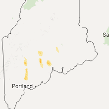
Hail Map for Tuesday, July 28, 2015

Number of Impacted Households on 7/28/2015
0
Impacted by 1" or Larger Hail
0
Impacted by 1.75" or Larger Hail
0
Impacted by 2.5" or Larger Hail
Square Miles of Populated Area Impacted on 7/28/2015
0
Impacted by 1" or Larger Hail
0
Impacted by 1.75" or Larger Hail
0
Impacted by 2.5" or Larger Hail


Cities Most Affected by Hail Storms of 7/28/2015
| Hail Size | Demographics of Zip Codes Affected | ||||||
|---|---|---|---|---|---|---|---|
| City | Count | Average | Largest | Pop Density | House Value | Income | Age |
Hail and Wind Damage Spotted on 7/28/2015
Filter by Report Type:Hail ReportsWind Reports
States Impacted
Maine, Massachusetts, Virginia, Montana, Alabama, Tennessee, Rhode Island, Iowa, New Hampshire, Arizona, Kentucky, TexasMaine
| Local Time | Report Details |
|---|---|
| 1:25 PM EDT | Trees down old corner rd... whitter r in franklin county ME, 68.5 miles W of Bangor, ME |
| 1:44 PM EDT | Trees on car on knoleton corner rd in franklin county ME, 65.4 miles N of Portland, ME |
| 1:56 PM EDT | Trees down in jay hyde rd... chesterville rd... east jay r in franklin county ME, 58.1 miles N of Portland, ME |
| 2:34 PM EDT | Trees down in kennebec county ME, 53.1 miles NNE of Portland, ME |
| 2:41 PM EDT | Trees down in kennebec county ME, 48.6 miles N of Portland, ME |
| 2:43 PM EDT | Trees down in kennebec county ME, 53.1 miles NNE of Portland, ME |
| 2:50 PM EDT | Ping Pong Ball sized hail reported near Old Town, ME, 15.2 miles N of Bangor, ME, general public posted a picture of large hailstones via facebook. hail size is oddly shaped but estimated to be ping pong size on minor axis. however... hail had signifi |
| 3:00 PM EDT | Quarter sized hail reported near Old Town, ME, 10.7 miles NNE of Bangor, ME, dime to quarter size hail |
| 3:01 PM EDT | Marrs point rd and rt 132 in androscoggin county ME, 35 miles NNE of Portland, ME |
| 3:15 PM EDT | Trees down on north rd near fayette town line in franklin county ME, 59.3 miles N of Portland, ME |
| 3:41 PM EDT | Trees down across highway 139... power outages in waldo county ME, 24.5 miles SW of Bangor, ME |
| 3:46 PM EDT | Quarter sized hail reported near Lisbon, ME, 26.8 miles NNE of Portland, ME |
| 3:54 PM EDT | Quarter sized hail reported near Durham, ME, 22.5 miles NNE of Portland, ME, based on photo |
| 3:55 PM EDT | Ping Pong Ball sized hail reported near Lisbon, ME, 26.8 miles NNE of Portland, ME, from photo |
| 4:00 PM EDT | Large branches and wires down in waldo county ME, 25.8 miles SSW of Bangor, ME |
| 5:30 PM EDT | Trees and wires down in somerset county ME, 33.8 miles W of Bangor, ME |
| 5:50 PM EDT | Trees and wires down - corrected - in pittsfied me in somerset county ME, 28 miles W of Bangor, ME |
| 5:52 PM EDT | Trees down in somerset county ME, 42.2 miles W of Bangor, ME |
| 6:35 PM EDT | Quarter sized hail reported near Albion, ME, 37.9 miles WSW of Bangor, ME, hail varied from 1/2 to 1 inch |
| 6:35 PM EDT | Trees down on albion rd in kennebec county ME, 41.1 miles WSW of Bangor, ME |
| 7:00 PM EDT | Trees down in waldo county ME, 41.5 miles SW of Bangor, ME |
Massachusetts
| Local Time | Report Details |
|---|---|
| 2:10 PM EDT | Route 91 southbound at greenfield town line...tree down across roa in franklin county MA, 70.3 miles ESE of Schenectady, NY |
| 2:12 PM EDT | Tree and wires down on lower roa in franklin county MA, 70.3 miles ESE of Schenectady, NY |
| 2:26 PM EDT | Tree hanging in road on keets road. road partially blocke in franklin county MA, 70.3 miles ESE of Schenectady, NY |
| 3:10 PM EDT | Trees and wires down on main and hollis street in worcester county MA, 22.5 miles NNW of Providence, RI |
Virginia
| Local Time | Report Details |
|---|---|
| 3:15 PM EDT | Tree down on rt 360 in charlotte county VA, 55.7 miles SW of Richmond, VA |
Montana
| Local Time | Report Details |
|---|---|
| 1:40 PM MDT | Storm damage reported in fallon county MT, 85.1 miles E of Miles City, MT |
Alabama
| Local Time | Report Details |
|---|---|
| 3:10 PM CDT | Several trees and phone lines down near coosa river rd and foreman rd. winds estimated 40-50 mph. time estimated from rada in elmore county AL, 51.8 miles W of Auburn, AL |
| 5:17 PM CDT | Trees and powerlines down on cooper ave in anniston between 18th and 19th streets. also trees down at 15th st and christine av in calhoun county AL, 57 miles E of Birmingham, AL |
| 5:21 PM CDT | Tree down near alice st and spring st in oxford. reported via social medi in calhoun county AL, 56.4 miles E of Birmingham, AL |
Tennessee
| Local Time | Report Details |
|---|---|
| 3:19 PM CDT | Tree down on hwy 76 in white house in robertson county TN, 21 miles NNE of Nashville, TN |
| 3:50 PM CDT | A few trees were downed by thunderstorm wind in franklin county TN, 46 miles WNW of Chattanooga, TN |
| 3:53 PM CDT | Roof damage to one business and structural damage to another business on midtown court in sumner county TN, 12.3 miles NE of Nashville, TN |
| 3:55 PM CDT | A few trees were downed by thunderstorm wind in franklin county TN, 54.5 miles W of Chattanooga, TN |
| 3:55 PM CDT | Goodlettsville city employee reported trees down across a roadway. relayed by nws employe in davidson county TN, 12 miles NNE of Nashville, TN |
| 4:00 PM CDT | Large tree snapped on anderson lane at myatt drive in davidson county TN, 8.6 miles NE of Nashville, TN |
| 4:00 PM CDT | Large tree down in backyard of home at 915 broadmorr drive in inglewood in davidson county TN, 5.1 miles NNE of Nashville, TN |
| 4:00 PM CDT | Power lines down on riviera drive in sumner county TN, 12 miles NE of Nashville, TN |
| 4:05 PM CDT | Trees blown down in old hickory in davidson county TN, 9.6 miles NE of Nashville, TN |
| 4:07 PM CDT | Power line down blocking elm hill pike near i-40. report via tspotter in davidson county TN, 7.7 miles E of Nashville, TN |
| 4:10 PM CDT | Large tree blown down at stewarts ferry pike and lebanon pike in donelson in davidson county TN, 6.6 miles E of Nashville, TN |
| 4:15 PM CDT | Trees and power lines down in woodland pointe area off bell road in davidson county TN, 8.4 miles ESE of Nashville, TN |
| 4:15 PM CDT | Large tree limb blown down in donelson in davidson county TN, 4.8 miles ESE of Nashville, TN |
| 4:18 PM CDT | 70 mph wind gusts currently near the hamilton church area of murfreesboro road in southeast davidson count in davidson county TN, 9.5 miles SE of Nashville, TN |
| 4:20 PM CDT | Tree branches blown down near nashville zoo in davidson county TN, 4.6 miles SE of Nashville, TN |
| 4:20 PM CDT | Two trees and power lines blown down on granny white pike near jt moore middle school in davidson county TN, 4.8 miles SSW of Nashville, TN |
| 4:25 PM CDT | Trees and power lines down at glendale lane at lealand lane in davidson county TN, 5.4 miles S of Nashville, TN |
| 4:27 PM CDT | Tree down on turning wheel lane between mcewen and liberty pike in williamson county TN, 16.4 miles S of Nashville, TN |
| 4:30 PM CDT | Tree snapped at stones river road and rocky ridge circle in rutherford county TN, 15.1 miles ESE of Nashville, TN |
| 4:30 PM CDT | Tree snapped in antioch in davidson county TN, 9.6 miles SE of Nashville, TN |
| 4:35 PM CDT | Tree down at carters creek and horton lane with roadway not passable in williamson county TN, 19 miles SSW of Nashville, TN |
Rhode Island
| Local Time | Report Details |
|---|---|
| 4:55 PM EDT | Three to 4 inch limbs down on water street at columbus avenue in bristol county RI, 9.4 miles SE of Providence, RI |
| 5:02 PM EDT | Large limb down on lindbergh avenue in bristol county RI, 12.3 miles SE of Providence, RI |
| 5:05 PM EDT | Large branch down on wires on linden street in bristol county RI, 12.3 miles SE of Providence, RI |
| 5:57 PM EDT | Quarter sized hail reported near Narragansett, RI, 25.9 miles S of Providence, RI, one half to 1 inch diameter hail and power outage due to lightning |
| 6:07 PM EDT | Multiple trees down across road on old boston neck road in washington county RI, 25.9 miles S of Providence, RI |
| 6:31 PM EDT | Large limbs blocking ocean road in washington county RI, 25.9 miles S of Providence, RI |
| 6:33 PM EDT | Branch and wires down on middlebridge road in washington county RI, 25.9 miles S of Providence, RI |
| 6:35 PM EDT | Straight line wind damage estimated to be around 60 mph occurred across old boston neck and boston neck road. most of the damage was large tree limbs that were southerl in washington county RI, 25.9 miles S of Providence, RI |
| 6:35 PM EDT | Large limb down 8 to 14 inches in diameter in the boston neck road and juliet road area in washington county RI, 25.9 miles S of Providence, RI |
Iowa
| Local Time | Report Details |
|---|---|
| 4:20 PM CDT | Trees and power lines down. tree on house. report relayed by e in marshall county IA, 36 miles NE of Des Moines, IA |
| 5:50 PM CDT | Tree down across highway 92. relayed by em. time estimate in marion county IA, 23.6 miles SE of Des Moines, IA |
| 6:54 PM CDT | Iowa dot rwis observation in wapello county IA, 55.3 miles NW of Kahoka, MO |
| 7:00 PM CDT | Telephone pole knock over at intersection of clay and gateway. wind gusts estimated at 60-65 mp in wapello county IA, 55.3 miles NW of Kahoka, MO |
| 7:00 PM CDT | Storm damage reported in wapello county IA, 62 miles NW of Kahoka, MO |
| 7:05 PM CDT | Numerous tree limbs down on houses and powerlines. time estimated from radar. report relayed from trained spotte in wapello county IA, 54.7 miles NW of Kahoka, MO |
| 7:42 PM CDT | Several small trees and branches down in streets. unknown diameter. estimated wind 60 mph. delayed report. time based on rada in washington county IA, 52 miles N of Kahoka, MO |
| 10:00 PM CDT | Storm damage reported in appanoose county IA, 64.2 miles WNW of Kahoka, MO |
New Hampshire
| Local Time | Report Details |
|---|---|
| 5:50 PM EDT | Trees and wires down in merrimack county NH, 56.8 miles WSW of Portland, ME |
Arizona
| Local Time | Report Details |
|---|---|
| 5:21 PM MST | Storm damage reported in pima county AZ, 6.4 miles S of Tucson, AZ |
| 5:25 PM MST | Downed power pole on valencia rd between 6th and nogales hwy in pima county AZ, 6.3 miles S of Tucson, AZ |
Kentucky
| Local Time | Report Details |
|---|---|
| 8:05 PM CDT | A few trees down blocking highway 280 between hwy 94e and hwy 121 in calloway county KY, 37.7 miles NNE of Mc Kenzie, TN |
Texas
| Local Time | Report Details |
|---|---|
| 9:15 PM CDT | Storm damage reported in roberts county TX, 71.1 miles NE of Amarillo, TX |
Connect with Interactive Hail Maps