

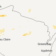
Hail Map for Saturday, July 30, 2011

Number of Impacted Households on 7/30/2011
0
Impacted by 1" or Larger Hail
0
Impacted by 1.75" or Larger Hail
0
Impacted by 2.5" or Larger Hail
Square Miles of Populated Area Impacted on 7/30/2011
0
Impacted by 1" or Larger Hail
0
Impacted by 1.75" or Larger Hail
0
Impacted by 2.5" or Larger Hail


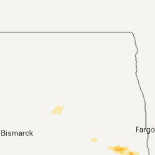
Cities Most Affected by Hail Storms of 7/30/2011
| Hail Size | Demographics of Zip Codes Affected | ||||||
|---|---|---|---|---|---|---|---|
| City | Count | Average | Largest | Pop Density | House Value | Income | Age |
| Bertha, MN | 1 | 1.75 | 1.75 | 16 | $38k | $28.4k | 35.1 |
| Merriman, NE | 1 | 1.75 | 1.75 | 0 | $30k | $26.6k | 47.3 |
Hail and Wind Damage Spotted on 7/30/2011
Filter by Report Type:Hail ReportsWind Reports
States Impacted
Minnesota, North Dakota, Illinois, Michigan, Wisconsin, Virginia, Missouri, Oklahoma, Arkansas, California, Kansas, Montana, Tennessee, Georgia, Nebraska, North Carolina, IdahoMinnesota
| Local Time | Report Details |
|---|---|
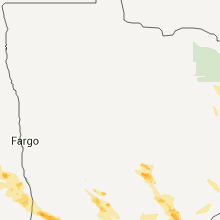
| 12:45 PM UTC | Several 3 to 5 inch diameter tree branches dow in wilkin county MN, 26.7 miles SE of Fargo, ND |
| 1:42 PM UTC | The strong wind gusts occurred from 842 to 847 am and were measured by a mndot rwis sit in wilkin county MN, 35.7 miles SE of Fargo, ND |
| 5:00 PM UTC | Ping Pong Ball sized hail reported near Herman, MN, 60.5 miles NNW of Montevideo, MN, hail occurred for approximately 15 minutes with ground still covered 30 minutes after onset. individual stored hailstones in freezer. |
| 5:09 PM UTC | Quarter sized hail reported near Donnelly, MN, 55.6 miles NNW of Montevideo, MN |
| 11:10 PM UTC | Golf Ball sized hail reported near Bertha, MN, 84.9 miles S of Bemidji, MN, spotter observed golf ball hail on the ground behind passing storm. time is estimated from radar. |
| 11:27 PM UTC | Quarter sized hail reported near Eagle Bend, MN, 89.3 miles NNE of Montevideo, MN |
| 12:00 AM UTC | Power line dow in crow wing county MN, 80.6 miles SSE of Bemidji, MN |
| 12:00 AM UTC | 5 to 6 inch diameter tree branches dow in otter tail county MN, 85.3 miles NNE of Montevideo, MN |
| 1:02 AM UTC | Trees up to 12 inches in diameter down. just west of hwy 16 in mille lacs county MN, 67.6 miles NNW of Minneapolis, MN |
| 1:19 AM UTC | Storm damage reported in mille lacs county MN, 57.1 miles NNW of Minneapolis, MN |
| 1:24 AM UTC | Numerous trees up to 35 inches in diameter down. time estimated based on rada in mille lacs county MN, 56.2 miles NNW of Minneapolis, MN |
| 1:26 AM UTC | Numerous trees down. some trees exceed one foot in diamete in mille lacs county MN, 57 miles NNW of Minneapolis, MN |
| 1:30 AM UTC | Quarter sized hail reported near Sauk Centre, MN, 65.8 miles NE of Montevideo, MN |
| 1:42 AM UTC | Half Dollar sized hail reported near Ogilvie, MN, 54.5 miles NNW of Minneapolis, MN |
| 1:42 AM UTC | Hundreds of trees down around the tow in isanti county MN, 49.9 miles N of Minneapolis, MN |
| 2:33 AM UTC | Half dozen trees down. some up to a foot in diameter. time estimated from rada in anoka county MN, 27.7 miles N of Minneapolis, MN |
| 4:20 AM UTC | 12 inch diameter and larger trees blown down in sibley county MN, 42 miles WSW of Minneapolis, MN |
North Dakota
| Local Time | Report Details |
|---|---|
| 1:40 PM UTC | Quarter sized hail reported near Enderlin, ND, 48.2 miles WSW of Fargo, ND |
| 4:20 PM UTC | Quarter sized hail reported near Fairmount, ND, 63.7 miles S of Fargo, ND, mostly pea to dime size but a few quarter sized hailstones mixed in late. |
Illinois
| Local Time | Report Details |
|---|---|
| 6:20 PM UTC | Spotter observed power poles damaged in sparta. time estimated from rada in randolph county IL, 42 miles SE of Saint Louis, MO |
Michigan
| Local Time | Report Details |
|---|---|
| 6:25 PM UTC | Branches estimated to be 6 inches in diameter. pea size hail also observe in ontonagon county MI, 66.9 miles N of Rhinelander, WI |
| 6:55 PM UTC | Trees down. time estimated by rada in ontonagon county MI, 62.4 miles N of Rhinelander, WI |
| 7:00 PM UTC | Trees down across town. sizes unknow in ontonagon county MI, 53.8 miles NNE of Rhinelander, WI |
| 7:00 PM UTC | Trees down. dimensions unknown. time estimated by radar. pea sized hail also reported in tow in ontonagon county MI, 62 miles N of Rhinelander, WI |
| 7:30 PM UTC | 6 inch diameter tree limb dow in baraga county MI, 56.6 miles W of Marquette, MI |
| 8:37 PM UTC | Storm damage reported in dickinson county MI, 58.4 miles SSW of Marquette, MI |
| 8:43 PM UTC | Large tree toppled on to car in dickinson county MI, 58.4 miles SSW of Marquette, MI |
| 8:45 PM UTC | 7 inch diameter tree dow in dickinson county MI, 54.7 miles SSW of Marquette, MI |
| 9:02 PM UTC | Storm damage reported in marquette county MI, 17.7 miles S of Marquette, MI |
| 9:05 PM UTC | Powerlines and trees down in lake township in menominee county MI, 64.2 miles NNE of Green Bay, WI |
| 9:10 PM UTC | Numerous 3 to 4 inch branches down. time estimated by rada in marquette county MI, 18.4 miles S of Marquette, MI |
| 9:15 PM UTC | 3 to 4 inch branches down. tree down on powerlines. metal launcher blown across the yar in menominee county MI, 66.3 miles S of Marquette, MI |
| 9:15 PM UTC | Tree fell onto a powerline. time estimated by rada in marquette county MI, 18.8 miles SSE of Marquette, MI |
| 9:15 PM UTC | 5 to 6 inch diameter tree limbs dow in menominee county MI, 46.1 miles NNE of Green Bay, WI |
| 9:15 PM UTC | Sheriffs office reported numerous trees and power lines down across northern menominee count in menominee county MI, 59.4 miles S of Marquette, MI |
| 9:15 PM UTC | Various trees down on powerlines. time estimated by rada in menominee county MI, 59.6 miles NNE of Green Bay, WI |
| 9:15 PM UTC | Trees down-approximately 1 ft in diameter. multiple reports of powerlines down. various 6-8 inch branches downe in menominee county MI, 71.5 miles S of Marquette, MI |
| 9:15 PM UTC | 3 ft diameter tree down in yard on county road g18. time estimated by rada in menominee county MI, 66.6 miles S of Marquette, MI |
| 9:20 PM UTC | Trees down across road and over powerlines. county road 38 is closed. time estimated by rada in menominee county MI, 66.3 miles S of Marquette, MI |
| 9:35 PM UTC | Trees down over road near m-35 in ford townshi in delta county MI, 58.8 miles SSE of Marquette, MI |
| 9:40 PM UTC | Tree down over the roa in delta county MI, 48.6 miles SSE of Marquette, MI |
| 10:08 PM UTC | Trees down across roa in delta county MI, 51 miles SE of Marquette, MI |
| 12:18 AM UTC | 7 inch diameter tree dow in dickinson county MI, 54.7 miles SSW of Marquette, MI |
Wisconsin
| Local Time | Report Details |
|---|---|
| 6:30 PM UTC | Trees down on state hwy 70 and powerlines down in fifiel in price county WI, 51.5 miles WNW of Rhinelander, WI |
| 6:54 PM UTC | Tent blown over at taylor county fair in taylor county WI, 57.2 miles SW of Rhinelander, WI |
| 7:09 PM UTC | In town of ne in oneida county WI, 4.4 miles NW of Rhinelander, WI |
| 7:10 PM UTC | Numerous trees down in small area of fort wilderness camp. diameter of trees from 6 inch to 1 foo in oneida county WI, 4.4 miles NW of Rhinelander, WI |
| 7:20 PM UTC | Estimated winds from 50 to 60 mph. inflatable raft blown off lak in oneida county WI, 16 miles NE of Rhinelander, WI |
| 7:20 PM UTC | Quarter sized hail reported near Merrill, WI, 34.2 miles SSW of Rhinelander, WI, downed trees and power lines also |
| 7:30 PM UTC | Debris on in lincoln county WI, 23.8 miles S of Rhinelander, WI |
| 7:30 PM UTC | 10 inch live tree down in lincoln county WI, 19.8 miles SW of Rhinelander, WI |
| 7:35 PM UTC | Many trees down in the downtown area in the city of wausa in marathon county WI, 48 miles SSW of Rhinelander, WI |
| 7:39 PM UTC | 12 inch branch blown in lincoln county WI, 34.2 miles SSW of Rhinelander, WI |
| 7:41 PM UTC | 8 to 12 inch trees down in langlade county WI, 27.2 miles SSE of Rhinelander, WI |
| 7:45 PM UTC | 4 to 5 ft trees uprooted/broke off above ground in downtown are in marathon county WI, 48 miles SSW of Rhinelander, WI |
| 8:14 PM UTC | Many trees and power lines down from tilleda to shawano in shawano county WI, 48.4 miles WNW of Green Bay, WI |
| 8:14 PM UTC | Several trees down and 6 to 8 inch branches in langlade county WI, 45.8 miles SE of Rhinelander, WI |
| 8:49 PM UTC | Two trees down blocking road in marinette county WI, 54.5 miles N of Green Bay, WI |
| 9:09 PM UTC | 2 ft diameter tree split in half in brown county WI, 4.8 miles SSW of Green Bay, WI |
| 9:10 PM UTC | Large maple tree down on roosevelt/north of maso in brown county WI, 0.5 miles ESE of Green Bay, WI |
| 9:20 PM UTC | 30 foot tree branch snapped off near corner of barker and harold streets on east side of cit in brown county WI, 0.5 miles ESE of Green Bay, WI |
| 9:26 PM UTC | Anemometer located 43 feet off the groun in calumet county WI, 26.9 miles SSW of Green Bay, WI |
| 9:30 PM UTC | 7 inch tree in winnebago county WI, 31.3 miles SW of Green Bay, WI |
| 9:42 PM UTC | Portable bathrooms tipped and trailer on side at eaa grounds in winnebago county WI, 43.8 miles SW of Green Bay, WI |
| 10:30 PM UTC | Many branches and limbs down. 1 foot trees down on roa in menominee county WI, 39.7 miles NW of Green Bay, WI |
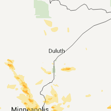
| 1:30 AM UTC | Trees down on power line. time estimated from rada in douglas county WI, 33.1 miles SSE of Duluth, MN |
| 1:45 AM UTC | Quarter sized hail reported near Solon Springs, WI, 33.1 miles SSE of Duluth, MN |
| 2:05 AM UTC | Quarter sized hail reported near Solon Springs, WI, 42.3 miles SE of Duluth, MN, hail in the town of barnes. |
| 4:45 AM UTC | Numerous trees and power lines down from ellsworth west to the intersection of county rd 10 and county rd in pierce county WI, 41.9 miles ESE of Minneapolis, MN |
| 4:55 AM UTC | A couple large trees down near the intersection of u.s. highway 63 and county highway 35. time estimate in pierce county WI, 44.2 miles SE of Minneapolis, MN |
Virginia
| Local Time | Report Details |
|---|---|
| 6:38 PM UTC | Tree down on rt 613 slippery ford rd in botetourt county VA, 22.1 miles N of Roanoke, VA |
| 6:45 PM UTC | Quarter sized hail reported near Covington, VA, 41.3 miles N of Roanoke, VA, hail slightly larger than quarters fell at cliffview drive. |
| 6:45 PM UTC | Quarter sized hail reported near Fincastle, VA, 18.5 miles N of Roanoke, VA, hail up to quarter sized began 245 pm and lasted 10 minutes. |
| 7:50 PM UTC | Tree down on power line on timberlane ave in roanoke county VA, 3.5 miles SW of Roanoke, VA |
| 7:50 PM UTC | Tree down on power line on colony lane in roanoke county VA, 4.5 miles SW of Roanoke, VA |
| 7:50 PM UTC | 3 trees down on home and power lines in roanoke county VA, 4 miles SW of Roanoke, VA |
| 7:55 PM UTC | Tree down on avon road in city of roanoke county VA, 2.3 miles WSW of Roanoke, VA |
| 7:55 PM UTC | Tree down on ashby st in city of roanoke county VA, 3.5 miles SW of Roanoke, VA |
| 7:58 PM UTC | Tree down on rosalind ave in city of roanoke county VA, 1.6 miles SSW of Roanoke, VA |
| 8:10 PM UTC | Many trees down 5 inches in diamete in city of roanoke county VA, 2.7 miles SW of Roanoke, VA |
| 8:20 PM UTC | Tree down on route 602 in franklin county VA, 20.5 miles SSW of Roanoke, VA |
| 8:30 PM UTC | Tree down on route 788 in franklin county VA, 23.9 miles SSW of Roanoke, VA |
| 9:18 PM UTC | Tree dwon on route 628 in campbell county VA, 34.9 miles ESE of Roanoke, VA |
| 9:22 PM UTC | Tree down on route 626 in campbell county VA, 36.3 miles E of Roanoke, VA |
| 9:22 PM UTC | Tree down on 100 block of route 712 in campbell county VA, 35.8 miles ESE of Roanoke, VA |
| 9:24 PM UTC | Power lines dow in campbell county VA, 35.9 miles E of Roanoke, VA |
| 9:35 PM UTC | Trees down on wisecarver roa in campbell county VA, 44.7 miles E of Roanoke, VA |
| 9:48 PM UTC | Trees dow in appomattox county VA, 59.8 miles E of Roanoke, VA |
| 10:02 PM UTC | Tree down on route 643 in appomattox county VA, 60.2 miles E of Roanoke, VA |
| 10:03 PM UTC | Trees down on lee-grant avenu in appomattox county VA, 62 miles E of Roanoke, VA |
| 10:04 PM UTC | Tree down on route 719 in appomattox county VA, 60.2 miles E of Roanoke, VA |
| 10:05 PM UTC | Tree down on route 604 in appomattox county VA, 60.1 miles E of Roanoke, VA |
| 10:05 PM UTC | Tree down on route 679 in appomattox county VA, 59 miles E of Roanoke, VA |
| 10:09 PM UTC | Tree down on route 644 in appomattox county VA, 61.8 miles E of Roanoke, VA |
| 10:09 PM UTC | Tree down on route 694 in appomattox county VA, 61.2 miles E of Roanoke, VA |
| 10:30 PM UTC | Tree down on route 671 county line road in charlotte county VA, 58.6 miles WSW of Richmond, VA |
| 10:34 PM UTC | Tree down on woodfork roa in charlotte county VA, 65.7 miles E of Roanoke, VA |
| 10:45 PM UTC | Numerous trees down on sandy creek church road. one on a power lin in pittsylvania county VA, 60.2 miles SE of Roanoke, VA |
Missouri
| Local Time | Report Details |
|---|---|
| 6:45 PM UTC | A window was blown out of a business...a traffic sign was partially detached from its mounting...and numerous power outages knocked out traffic signals. time of event e in greene county MO, 3.4 miles S of Springfield, MO |
Oklahoma
| Local Time | Report Details |
|---|---|
| 7:50 PM UTC | Storm damage reported in logan county OK, 43.5 miles N of Oklahoma City, OK |
| 9:45 PM UTC | Shed blown over near dover and minor tree damage in dover. winds estimated at 65 mph. time estimated using radar archiv in kingfisher county OK, 41.3 miles NNW of Oklahoma City, OK |
Arkansas
| Local Time | Report Details |
|---|---|
| 8:21 PM UTC | Several large trees have been downed across plainvie in white county AR, 51.8 miles NE of Little Rock, AR |
| 8:21 PM UTC | Quarter sized hail reported near Judsonia, AR, 51.8 miles NE of Little Rock, AR |
| 11:23 PM UTC | Wind gust measured by the xna aso in benton county AR, 62 miles N of Fort Smith, AR |
California
| Local Time | Report Details |
|---|---|
| 8:39 PM UTC | Spotter report in san bernardino county CA, 53.4 miles WNW of Yucca Valley, CA |
| 9:00 PM UTC | Powerlines down on 7th and d streets due to wind knocking trees on lines in san bernardino county CA, 59 miles WNW of Yucca Valley, CA |
| 9:54 PM UTC | A truck stop employee at kramar junction estimated thunderstorm winds of at least 60 mp in san bernardino county CA, 76.1 miles NNE of Los Angeles, CA |
| 10:13 PM UTC | Measured by wind tower on runway 0 in kern county CA, 61.7 miles NNE of Los Angeles, CA |
Kansas
| Local Time | Report Details |
|---|---|
| 10:13 PM UTC | A semi truck hauling an empty cattle trailer was overturned on hwy5 in meade county KS, 58.5 miles SE of Garden City, KS |
| 1:04 AM UTC | Storm damage reported in hodgeman county KS, 50.3 miles E of Garden City, KS |
Montana
| Local Time | Report Details |
|---|---|
| 10:40 PM UTC | Storm damage reported in cascade county MT, 36.3 miles SW of Great Falls, MT |
| 11:26 PM UTC | Tree 8 inches in diameter snapped off half way up the trunk south of great falls near the rive in cascade county MT, 0.9 miles ESE of Great Falls, MT |
| 12:15 AM UTC | Strong thunderstorm winds blew the roof of a vacant mobile home off on the south side of great falls and debris was thrown close to nearby power lines. fire department in cascade county MT, 0.9 miles ESE of Great Falls, MT |
Tennessee
| Local Time | Report Details |
|---|---|
| 10:40 PM UTC | A few trees were downed on state highway 76 west of adam in robertson county TN, 32.5 miles NNW of Nashville, TN |
Georgia
| Local Time | Report Details |
|---|---|
| 11:15 PM UTC | A fort stewart official reported two 24 inch diameter trees down near wright army airfiel in liberty county GA, 31.4 miles WSW of Savannah, GA |
Nebraska
| Local Time | Report Details |
|---|---|
| 12:04 AM UTC | Golf Ball sized hail reported near Merriman, NE, 62.9 miles WSW of Valentine, NE, mostly quarter sized hail falling but several stones as large as golf balls. |
| 12:30 AM UTC | Quarter sized hail reported near Merriman, NE, 71.1 miles W of Valentine, NE |
North Carolina
| Local Time | Report Details |
|---|---|
| 1:03 AM UTC | Several trees blown down in a subdivision between sulphor springs rd and south post r in cleveland county NC, 39.2 miles W of Charlotte, NC |
Idaho
| Local Time | Report Details |
|---|---|
| 2:05 AM UTC | Dewey and 33rd...north end. tree branch down. police road closure due to possible hot power line down. time estimated from radar and airport observation in ada county ID, 1.9 miles W of Boise, ID |
Connect with Interactive Hail Maps