

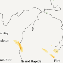
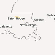
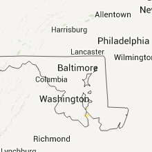
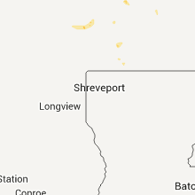
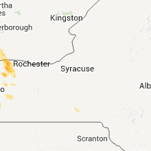
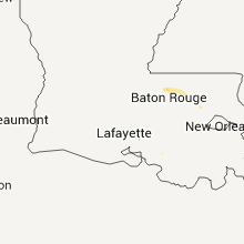
Hail Map for Sunday, July 31, 2011

Number of Impacted Households on 7/31/2011
0
Impacted by 1" or Larger Hail
0
Impacted by 1.75" or Larger Hail
0
Impacted by 2.5" or Larger Hail
Square Miles of Populated Area Impacted on 7/31/2011
0
Impacted by 1" or Larger Hail
0
Impacted by 1.75" or Larger Hail
0
Impacted by 2.5" or Larger Hail


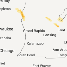


Cities Most Affected by Hail Storms of 7/31/2011
| Hail Size | Demographics of Zip Codes Affected | ||||||
|---|---|---|---|---|---|---|---|
| City | Count | Average | Largest | Pop Density | House Value | Income | Age |
| Reeder, ND | 1 | 2.00 | 2.00 | 1 | $21k | $24.6k | 49.5 |
| Spearfish, SD | 1 | 2.00 | 2.00 | 62 | $98k | $30.2k | 38.6 |
| Wisconsin Rapids, WI | 1 | 2.00 | 2.00 | 202 | $86k | $45.6k | 44.8 |
| Finley, ND | 1 | 1.75 | 1.75 | 2 | $41k | $36.3k | 45.5 |
| Bison, SD | 1 | 1.75 | 1.75 | 0 | $35k | $28.6k | 46.8 |
| Hurley, NM | 1 | 1.75 | 1.75 | 8 | $56k | $25.6k | 44.0 |
Hail and Wind Damage Spotted on 7/31/2011
Filter by Report Type:Hail ReportsWind Reports
States Impacted
South Carolina, Georgia, Kansas, Delaware, Arkansas, North Carolina, Utah, Missouri, Alabama, Wisconsin, South Dakota, Oregon, California, New Mexico, Arizona, North Dakota, Michigan, New York, MinnesotaSouth Carolina
| Local Time | Report Details |
|---|---|
| 5:40 PM UTC | Quarter sized hail reported near Gresham, SC, 64.5 miles NNE of Charleston, SC, nickel to quarter size hail fell briefly |
| 8:38 PM UTC | Law enforcement reported trees and powerlines down on cooper store roa in berkeley county SC, 2.8 miles W of Charleston, SC |
| 8:45 PM UTC | Trees down near heyward and pickens sts in richland county SC, 66.3 miles ENE of Augusta, GA |
| 8:45 PM UTC | Trees down near heyward and pickens sts in richland county SC, 65.2 miles NE of Augusta, GA |
| 8:49 PM UTC | Trees in roadway on main st also monticell rd reported by highway patrol in richland county SC, 65.2 miles NE of Augusta, GA |
| 9:15 PM UTC | Quarter sized hail reported near Laurens, SC, 39.2 miles SE of Greenville, SC, county comms reports quarter sized hail on ekom beach road. |
| 9:28 PM UTC | A tree was down on the whitemire highway just out of joann in laurens county SC, 54.2 miles ESE of Greenville, SC |
| 9:29 PM UTC | Another tree down along highway 76 going toward kinard in laurens county SC, 54.4 miles ESE of Greenville, SC |
| 10:08 PM UTC | South carolina highway patrol reported one tree down near the intersection of jones swamp road and wolfe creek roa in colleton county SC, 43.9 miles WSW of Charleston, SC |
| 10:10 PM UTC | Tree down on whitmir in union county SC, 57 miles ESE of Greenville, SC |
| 10:14 PM UTC | South carolina highway patrol reported one tree down near the intersection of deliverence road and red root roa in colleton county SC, 49.6 miles WSW of Charleston, SC |
| 10:15 PM UTC | Power lines down on lockhart dr and north 2nd st.61 in union county SC, 46.2 miles SW of Charlotte, NC |
| 10:15 PM UTC | Tree down on pineland road near sonoco roa in union county SC, 47.1 miles SW of Charlotte, NC |
| 10:18 PM UTC | South carolina highway patrol reported one tree down near the intersection of jefferies blvd and oakland driv in colleton county SC, 44.1 miles WSW of Charleston, SC |
| 10:45 PM UTC | South carolina highway patrol reported one tree down near the intersection of saint peters road and highway 6 in colleton county SC, 41.6 miles SW of Charleston, SC |
| 10:55 PM UTC | South carolina highway patrol reported one tree down on crumley roa in colleton county SC, 42.4 miles SW of Charleston, SC |
| 11:39 PM UTC | South carolina highway patrol reported one tree down near rice shire road and frontage roa in jasper county SC, 31.2 miles NNE of Savannah, GA |
| 12:57 AM UTC | Large branches broken in spartanburg county SC, 47.4 miles ENE of Greenville, SC |
Georgia
| Local Time | Report Details |
|---|---|
| 7:12 PM UTC | A few large limbs blown down with the storm near and to the southwest of tugalo da in habersham county GA, 45 miles WSW of Greenville, SC |
| 9:38 PM UTC | Storm damage reported in chatham county GA, 7.6 miles WNW of Savannah, GA |
| 9:42 PM UTC | Law enforcement reported a tree fell on a house along osteen stree in chatham county GA, 6.3 miles NW of Savannah, GA |
| 9:42 PM UTC | Law enforecemt reported one tree down on commonwealth avenu in chatham county GA, 6.3 miles NW of Savannah, GA |
| 9:47 PM UTC | A 70 mph gust was reported at savannah international airpor in chatham county GA, 7.6 miles WNW of Savannah, GA |
| 9:48 PM UTC | Law enforcement reported a tree down near the intersection of highway 80 and louisville roa in chatham county GA, 9 miles WNW of Savannah, GA |
| 11:13 PM UTC | Law enforcement reported a tree down near the intersection of south main street and ryon avenu in liberty county GA, 34.2 miles WSW of Savannah, GA |
| 11:13 PM UTC | Law enforcement reported one tree down on ashmore roa in liberty county GA, 33.9 miles WSW of Savannah, GA |
| 11:17 PM UTC | Law enforcement reported one tree and powerlines down near the intersection of red bird lane and cypress bay loop roa in bryan county GA, 27.6 miles W of Savannah, GA |
| 11:43 PM UTC | Law enforcement reported one tree down near the intersection of carter drive and griffen roa in liberty county GA, 38.6 miles SW of Savannah, GA |
| 12:40 AM UTC | Skywarn spotter reported tin roof ripped off shed and several trees and power lines down. quarter size hail was also observe in wayne county GA, 54.9 miles WSW of Savannah, GA |
| 12:50 AM UTC | 911 call center reported 2 trees down near the intersection of bluff road and linden road. they also reported another tree down on kerry davis roa in wayne county GA, 53.5 miles WSW of Savannah, GA |
Kansas
| Local Time | Report Details |
|---|---|
| 7:17 PM UTC | Storm damage reported in russell county KS, 24.6 miles ESE of Hays, KS |
| 8:11 PM UTC | Reports of trucks being blown over on interstate 70 at the ellis junction. no actual magnitude reported. from 800 mhz radi in ellis county KS, 13.2 miles WNW of Hays, KS |
| 8:15 PM UTC | Storm damage reported in ellis county KS, 13.4 miles WNW of Hays, KS |
| 8:20 PM UTC | 100 gallon horse tank three-quarters full was blown into shed in sedgwick county KS, 19.4 miles SW of Wichita, KS |
| 9:10 PM UTC | Storm damage reported in trego county KS, 27.1 miles W of Hays, KS |
| 10:01 PM UTC | Several large trees downed with some power lines down als in allen county KS, 9.7 miles N of Chanute, KS |
| 10:42 PM UTC | Tree limbs downe in ellsworth county KS, 53.5 miles ESE of Hays, KS |
| 10:55 PM UTC | Semi-trailer blown off highway 15 in ellsworth county KS, 52.5 miles ESE of Hays, KS |
| 10:57 PM UTC | Power lines downe in ellsworth county KS, 54 miles ESE of Hays, KS |
| 11:00 PM UTC | Storm damage reported in ellsworth county KS, 53.5 miles ESE of Hays, KS |
| 11:01 PM UTC | Numerous trees downe in ellsworth county KS, 53.5 miles ESE of Hays, KS |
Delaware
| Local Time | Report Details |
|---|---|
| 8:00 PM UTC | Poles down in clayton... blocked roadwa in kent county DE, 52.5 miles E of Baltimore, MD |
Arkansas
| Local Time | Report Details |
|---|---|
| 8:05 PM UTC | A shed was blown into a fenc in saline county AR, 15.6 miles SW of Little Rock, AR |
| 8:10 PM UTC | Large tree limbs were down on a rv and caused significant damage to the r in pulaski county AR, 11.4 miles NW of Little Rock, AR |
| 8:26 PM UTC | Trees down across sherwood with some trees down on powerlines and houses. no injuries reporte in pulaski county AR, 6.7 miles NNE of Little Rock, AR |
| 8:47 PM UTC | Several large trees were blown down with one tree being struck by lightnin in pulaski county AR, 6 miles SSE of Little Rock, AR |
| 9:00 PM UTC | Quarter sized hail reported near Sheridan, AR, 33.2 miles SSW of Little Rock, AR |
| 9:45 PM UTC | Numerous trees snapped. power poles and lines along hwy 71 down across road. several homes slighly damage in sevier county AR, 18.6 miles W of Nashville, AR |
| 11:30 PM UTC | At the intersection of u.s. 79/278 and ar 7...damage occured due to winds of 75 mph. damage consisted of a roof taken off a motel...and thrown into a vacant house behin in ouachita county AR, 63 miles ESE of Nashville, AR |
North Carolina
| Local Time | Report Details |
|---|---|
| 8:09 PM UTC | Tree down near intersection of u.s. 601 and nc route 26 in surry county NC, 76.6 miles N of Charlotte, NC |
| 8:14 PM UTC | One tree down at 9310 u.s. highway 60 in surry county NC, 74.6 miles N of Charlotte, NC |
| 9:15 PM UTC | County comms reports numerous trees down in the mocksville city limit in davie county NC, 49.3 miles NNE of Charlotte, NC |
| 9:35 PM UTC | Tree down at old greensboro and clodfelter road in davidson county NC, 60.3 miles NE of Charlotte, NC |
| 9:54 PM UTC | Multiple trees down in the vicinity of exit 96 on interstate 85 in davidson county NC, 54.9 miles NE of Charlotte, NC |
| 10:00 PM UTC | One tree down near the intersection of faith road and jake alexander roa in rowan county NC, 36.4 miles NE of Charlotte, NC |
| 10:00 PM UTC | Tree down and closed becks nursery road. time estimate in davidson county NC, 52.4 miles NE of Charlotte, NC |
| 10:02 PM UTC | Tree down on allred road in davidson county NC, 52 miles NE of Charlotte, NC |
| 10:03 PM UTC | One large limb down blocking long ferry road near the intersection with blue heron roa in rowan county NC, 41 miles NE of Charlotte, NC |
| 10:04 PM UTC | Tree down on old highway 64 in davidson county NC, 52.9 miles NE of Charlotte, NC |
| 10:53 PM UTC | Tree down on a house on lowder st in stanly county NC, 36.5 miles ENE of Charlotte, NC |
| 10:54 PM UTC | Tree blown down on morgan road. time estimate in stanly county NC, 36.4 miles ENE of Charlotte, NC |
| 11:00 PM UTC | Tree blown down along highway 205. time estimate in stanly county NC, 27.6 miles E of Charlotte, NC |
| 11:00 PM UTC | Multiple trees down near the intersection of miller bridge road and warlick chapel road. other trees reported down on other parts of miller bridge roa in burke county NC, 49.4 miles NW of Charlotte, NC |
| 11:25 PM UTC | Tree blown down on red hill mt. vernon church road. time estimate in anson county NC, 40.2 miles ESE of Charlotte, NC |
| 11:25 PM UTC | Tree blown down on hopewell church road. time estimate in anson county NC, 36 miles ESE of Charlotte, NC |
| 11:35 PM UTC | A couple of trees down in the area southeast of casar. one along the road and another nearb in cleveland county NC, 46.3 miles WNW of Charlotte, NC |
| 11:35 PM UTC | One tree down on casar-lawndale roa in cleveland county NC, 46.3 miles WNW of Charlotte, NC |
| 11:35 PM UTC | Tree blown down along bill curlee road. time estimate in anson county NC, 37.4 miles ESE of Charlotte, NC |
| 11:45 PM UTC | Tree blown down near highway 109 and pleasant hill church road. time estimate in anson county NC, 45.4 miles ESE of Charlotte, NC |
| 12:15 AM UTC | Numerous trees down in the county. this includes the spindale...forest city...and rutherfordton area in rutherford county NC, 54.3 miles NE of Greenville, SC |
Utah
| Local Time | Report Details |
|---|---|
| 9:26 PM UTC | Beaver municipal airport in beaver county UT, 41.1 miles SW of Monroe, UT |
Missouri
| Local Time | Report Details |
|---|---|
| 9:55 PM UTC | 8 inch tree limb removed from tre in christian county MO, 16.1 miles SSE of Springfield, MO |
Alabama
| Local Time | Report Details |
|---|---|
| 9:55 PM UTC | A few trees down along jeff hamilton rd in west mobile in mobile county AL, 10.8 miles WSW of Mobile, AL |
Wisconsin
| Local Time | Report Details |
|---|---|
| 9:55 PM UTC | Quarter sized hail reported near Alma Center, WI, 46.5 miles NNE of La Crosse, WI, time estimated based on radar |
| 11:09 PM UTC | Hen Egg sized hail reported near Wisconsin Rapids, WI, 84.9 miles ENE of La Crosse, WI |
South Dakota
| Local Time | Report Details |
|---|---|
| 10:30 PM UTC | Quarter sized hail reported near Spearfish, SD, 44.8 miles NW of Rapid City, SD |
| 4:30 PM MDT | Hen Egg sized hail reported near Spearfish, SD, 42.5 miles NW of Rapid City, SD |
| 10:35 PM UTC | Storm damage reported in lawrence county SD, 43 miles NW of Rapid City, SD |
| 10:40 PM UTC | Lasted 15 minutes big branches broken in butte county SD, 45.7 miles NNW of Rapid City, SD |
| 11:00 PM UTC | Storm damage reported in meade county SD, 25.8 miles NNW of Rapid City, SD |
| 11:15 PM UTC | Storm damage reported in meade county SD, 23.7 miles NNW of Rapid City, SD |
| 11:50 PM UTC | Quarter sized hail reported near Faith, SD, 69.5 miles NNE of Rapid City, SD |
| 12:48 AM UTC | Storm damage reported in perkins county SD, 102.2 miles NNE of Rapid City, SD |
| 12:49 AM UTC | Storm damage reported in perkins county SD, 100 miles NNE of Rapid City, SD |
| 12:50 AM UTC | Storm damage reported in meade county SD, 54.4 miles NE of Rapid City, SD |
| 12:50 AM UTC | Golf Ball sized hail reported near Bison, SD, 101.1 miles NNE of Rapid City, SD |
| 1:05 AM UTC | Half Dollar sized hail reported near Bison, SD, 104 miles NNE of Rapid City, SD |
| 1:10 AM UTC | Storm damage reported in meade county SD, 58.8 miles NE of Rapid City, SD |
| 1:26 AM UTC | Storm damage reported in perkins county SD, 108.2 miles SW of Bismarck, ND |
| 1:45 AM UTC | Storm damage reported in perkins county SD, 96.5 miles SW of Bismarck, ND |
| 1:45 AM UTC | 10 inch diameter trees broken and uprooted in perkins county SD, 96.5 miles SW of Bismarck, ND |
| 1:45 AM UTC | Quarter sized hail reported near Lemmon, SD, 96.5 miles SW of Bismarck, ND |
| 1:55 AM UTC | Storm damage reported in perkins county SD, 88.7 miles SW of Bismarck, ND |
| 1:55 AM UTC | 6-8 inch diameter tree branches broken in perkins county SD, 89.1 miles SW of Bismarck, ND |
| 1:56 AM UTC | Half Dollar sized hail reported near Lemmon, SD, 89.8 miles SW of Bismarck, ND |
| 2:00 AM UTC | Storm damage reported in corson county SD, 82.9 miles SW of Bismarck, ND |
| 2:00 AM UTC | Sddot rwis in perkins county SD, 91.2 miles SW of Bismarck, ND |
| 2:00 AM UTC | Storm damage reported in perkins county SD, 89.1 miles SW of Bismarck, ND |
| 3:45 AM UTC | Half Dollar sized hail reported near Meadow, SD, 92.6 miles NNE of Rapid City, SD |
| 4:05 AM UTC | Quarter sized hail reported near Meadow, SD, 110 miles NNE of Rapid City, SD, 50-60 mph wind accompanied the hail |
| 4:10 AM UTC | Sddot rwis in perkins county SD, 107.6 miles NNE of Rapid City, SD |
| 4:30 AM UTC | Tree branches dow in corson county SD, 102.7 miles SSW of Bismarck, ND |
| 5:00 AM UTC | Bear creek raws. time estimated from rada in dewey county SD, 73.4 miles NW of Pierre, SD |
| 6:01 AM UTC | Storm damage reported in meade county SD, 8.1 miles NE of Rapid City, SD |
| 7:32 AM UTC | Storm damage reported in walworth county SD, 81 miles N of Pierre, SD |
| 7:45 AM UTC | Trees and large branches down in and around mobridge. powerlines down with isolated power outage in walworth county SD, 81 miles N of Pierre, SD |
Oregon
| Local Time | Report Details |
|---|---|
| 10:47 PM UTC | Rained 0.25 inches of rain in 30 minutes then wind gusted to 58 mph. also rained 0.41 inches yesterda in harney county OR, 79.6 miles SSE of Burns, OR |
| 11:46 PM UTC | 0.25 inches of rain in 30 minutes and max wind gust to 58 mp in harney county OR, 79.6 miles SSE of Burns, OR |
| 12:58 AM UTC | Public relayed report to malheur county sheriff of broken tree brances in vale with local winds to 60 or 70 mp in malheur county OR, 58.4 miles WNW of Boise, ID |
California
| Local Time | Report Details |
|---|---|
| 11:35 PM UTC | 3 power poles reported down by wind. anza borrego state park ranger in san diego county CA, 63.3 miles ENE of San Diego, CA |
New Mexico
| Local Time | Report Details |
|---|---|
| 11:35 PM UTC | Golf Ball sized hail reported near Hurley, NM, 10.1 miles ESE of Silver City, NM, brief period of golfball size hail. |
Arizona
| Local Time | Report Details |
|---|---|
| 12:45 AM UTC | 2 mobile homes severely damaged in pinal county AZ, 40.3 miles SSE of Phoenix, AZ |
| 1:24 AM UTC | 65 mph winds damaged roof of neighboring house in pinal county AZ, 43.9 miles SSE of Phoenix, AZ |
| 2:20 AM UTC | Large tree blown down near higley and baseline road in maricopa county AZ, 21.3 miles ESE of Phoenix, AZ |
| 2:30 AM UTC | Four transmission lines for power knocked down in the northern tohono oodham nation and has resulted to loss of power to majority of the natio in pima county AZ, 57.3 miles WSW of Tucson, AZ |
| 2:30 AM UTC | Block wall 10 feet long and 6 feet tall blown ove in maricopa county AZ, 24.1 miles SE of Phoenix, AZ |
| 2:40 AM UTC | Numerous power poles down just south of gilbert rd and hunt hw in pinal county AZ, 23.8 miles SE of Phoenix, AZ |
| 4:26 AM UTC | Several downed power poles along with residential structure damage including backyard sheds and roof shingles in the vicinity of the 27th ave and van buren in phoeni in maricopa county AZ, 2.5 miles W of Phoenix, AZ |
North Dakota
| Local Time | Report Details |
|---|---|
| 1:55 AM UTC | Hen Egg sized hail reported near Bancroft, ND, 116.3 miles WSW of Bismarck, ND, hail lasted around 5 minutes. |
| 2:15 AM UTC | Wind gust tore a small deck off of a hous in sioux county ND, 77.7 miles SW of Bismarck, ND |
| 2:44 AM UTC | Quarter sized hail reported near Mott, ND, 84.2 miles WSW of Bismarck, ND, 50 mph winds and heavy rain. |
| 2:45 AM UTC | Delayed report. large trees blown down in carson. numerous large branches snapped. strong winds lasted 30 minute in grant county ND, 46.1 miles SW of Bismarck, ND |
| 3:00 AM UTC | Occured from 935 - 1035 pm cdt/835 - 935 pm md in grant county ND, 66.5 miles SW of Bismarck, ND |
| 3:15 AM UTC | Quarter sized hail reported near Kathryn, ND, 57.2 miles WSW of Fargo, ND |
| 3:43 AM UTC | Storm damage reported in morton county ND, 15.4 miles WNW of Bismarck, ND |
| 3:45 AM UTC | Two 4 inch diameter trees snapped off at ground leve in burleigh county ND, 7.1 miles NNW of Bismarck, ND |
| 3:55 AM UTC | Horizontal rain in morton county ND, 5.5 miles WNW of Bismarck, ND |
| 3:56 AM UTC | Pea sized hail occurring in addition to wind in burleigh county ND, 0.3 miles N of Bismarck, ND |
| 4:01 AM UTC | Estimated 60-70 mph wind gust in burleigh county ND, 1 miles ENE of Bismarck, ND |
| 4:04 AM UTC | Pea to dime size hai in morton county ND, 5.5 miles WNW of Bismarck, ND |
| 4:04 AM UTC | Storm damage reported in burleigh county ND, 0.3 miles N of Bismarck, ND |
| 4:04 AM UTC | Tree limbs down in morton county ND, 5.5 miles WNW of Bismarck, ND |
| 4:08 AM UTC | Small trees snapped at nws office in burleigh county ND, 0.3 miles N of Bismarck, ND |
| 4:09 AM UTC | Storm damage reported in burleigh county ND, 0.3 miles N of Bismarck, ND |
| 4:10 AM UTC | 35 foot tall tree with 14 inch diameter broken. employee estimates 80 to 85 mph win in burleigh county ND, 10 miles N of Bismarck, ND |
| 4:10 AM UTC | Trampoline flew into the side of home causing damage. winds estimated at 80 to 85 mp in burleigh county ND, 6.5 miles N of Bismarck, ND |
| 4:17 AM UTC | Power flashes occurring. est 80-90 mph gust in burleigh county ND, 0.3 miles N of Bismarck, ND |
| 4:17 AM UTC | Several tree limbs snapped with a diameter of 6 inches from 70 mph wind gust in morton county ND, 5.5 miles WNW of Bismarck, ND |
| 4:18 AM UTC | Storm damage reported in burleigh county ND, 10 miles N of Bismarck, ND |
| 4:18 AM UTC | Average 2 to 4 inch diameter tree limbs down...largest 10 inches in size. gazebo canopy torn of in morton county ND, 5.5 miles WNW of Bismarck, ND |
| 4:24 AM UTC | Winds of 61 mph or greater occurred for 20 minutes from 1104 pm to 1124 pm. peak wind gust was 68 mph at 1109 p in burleigh county ND, 0.3 miles N of Bismarck, ND |
| 4:35 AM UTC | Extensive large tree damage throughout tow in burleigh county ND, 23.2 miles E of Bismarck, ND |
| 4:48 AM UTC | Arb observer 11 miles southwest of tuttle estimated 80 mph wind in burleigh county ND, 33.2 miles ENE of Bismarck, ND |
| 5:45 AM UTC | Golf Ball sized hail reported near Finley, ND, 63.1 miles SE of Devils Lake, ND |
| 5:54 AM UTC | Trees down. estimated 60 to 70 mph wind in foster county ND, 50 miles S of Devils Lake, ND |
| 6:08 AM UTC | Large tree down in a yard. estimated 60 to 70 mph wind in foster county ND, 39.6 miles SSW of Devils Lake, ND |
| 6:30 AM UTC | Numerous large trees uprooted in town. two grain hopppers blown over at the kensal farmers elevator. wind speeds estimated 70 to 80 mp in stutsman county ND, 56.4 miles S of Devils Lake, ND |
| 6:40 AM UTC | Trees uprooted in tow in benson county ND, 11 miles SW of Devils Lake, ND |
| 6:45 AM UTC | Flag pole down and tree branches dow in nelson county ND, 22.7 miles ESE of Devils Lake, ND |
| 7:13 AM UTC | Objects blown around yard with strong wind gust in mcintosh county ND, 63 miles SE of Bismarck, ND |
| 7:15 AM UTC | Several trees in a shelterbelt were blown dow in steele county ND, 60 miles SE of Devils Lake, ND |
| 7:35 AM UTC | The wind gust was measured by the cooperstown airport awo in griggs county ND, 57.8 miles SE of Devils Lake, ND |
| 7:35 AM UTC | There were 20 to 25 trees uprooted in hope. three trees landed on cars and two landed on homes. the grain elevator was also damage in steele county ND, 53.8 miles NW of Fargo, ND |
| 8:00 AM UTC | Damage to a grain bin vicinity of hope nd. time of event based on radar velocity signatur in steele county ND, 53.8 miles NW of Fargo, ND |
| 8:05 AM UTC | Strong winds damaged a farmstead at galesburg. a large steel gas tank was blown off its mooring in traill county ND, 40.3 miles NW of Fargo, ND |
| 8:25 AM UTC | Numerous 6 to 10 inch diameter tree branches were blown dow in cass county ND, 27.4 miles NW of Fargo, ND |
| 9:00 AM UTC | Large tree split in two from strong wind in cass county ND, 10.1 miles SSW of Fargo, ND |
| 9:20 AM UTC | Many large tree branches blown down by the strong wind. crops flattened by the wind and rai in richland county ND, 20.5 miles S of Fargo, ND |
Michigan
| Local Time | Report Details |
|---|---|
| 2:02 AM UTC | 18 inch diameter tree down on power lines just north of downtow in mason county MI, 69 miles SW of Traverse City, MI |
| 7:50 AM UTC | 3 to 4 inch diameter limbs down in saginaw county MI, 33.1 miles NNW of Flint, MI |
New York
| Local Time | Report Details |
|---|---|
| 7:40 AM UTC | Quarter sized hail reported near Lyndonville, NY, 38.9 miles NE of Buffalo, NY |
| 7:44 AM UTC | Quarter sized hail reported near Gaines, NY, 43.5 miles NE of Buffalo, NY, quarter sized hail |
| 7:55 AM UTC | Quarter sized hail reported near Medina, NY, 33.8 miles NE of Buffalo, NY |
| 8:05 AM UTC | Quarter sized hail reported near Shelby, NY, 32.5 miles NE of Buffalo, NY, quarter size hail. |
| 10:34 AM UTC | Wires dowm in allegany county NY, 48.5 miles SE of Buffalo, NY |
| 10:34 AM UTC | Wires down in allegany county NY, 48.5 miles SE of Buffalo, NY |
Minnesota
| Local Time | Report Details |
|---|---|
| 11:46 AM UTC | Large trees blown down. street sign blown dow in douglas county MN, 64.8 miles N of Montevideo, MN |
| 11:47 AM UTC | Powerline downed in douglas county MN, 73.1 miles N of Montevideo, MN |
| 11:55 AM UTC | A grove of trees blown down between county road 114 and county road in douglas county MN, 70.6 miles N of Montevideo, MN |
Connect with Interactive Hail Maps