

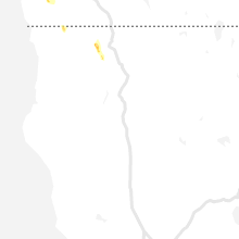
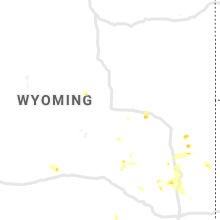
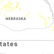
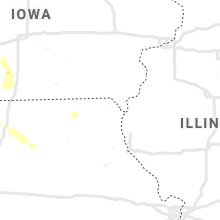
Hail Map for Friday, July 30, 2021

Number of Impacted Households on 7/30/2021
0
Impacted by 1" or Larger Hail
0
Impacted by 1.75" or Larger Hail
0
Impacted by 2.5" or Larger Hail
Square Miles of Populated Area Impacted on 7/30/2021
0
Impacted by 1" or Larger Hail
0
Impacted by 1.75" or Larger Hail
0
Impacted by 2.5" or Larger Hail


Cities Most Affected by Hail Storms of 7/30/2021
| Hail Size | Demographics of Zip Codes Affected | ||||||
|---|---|---|---|---|---|---|---|
| City | Count | Average | Largest | Pop Density | House Value | Income | Age |
| Murray, IA | 1 | 1.75 | 1.75 | 12 | $50k | $32.9k | 39.5 |
Hail and Wind Damage Spotted on 7/30/2021
Filter by Report Type:Hail ReportsWind Reports
Georgia
| Local Time | Report Details |
|---|---|
| 4:55 PM EDT | Reports of multiple trees downed onto roadways on the eastern side of the city of dalton in whitfield county GA, 27.5 miles SE of Chattanooga, TN |
| 4:57 PM EDT | Several reports of trees downed onto structures on the eastern side of the city of dalton in whitfield county GA, 27.5 miles SE of Chattanooga, TN |
Tennessee
| Local Time | Report Details |
|---|---|
| 4:35 PM CDT | Tree down on power lines at 1518 turnpike in lawrence county TN, 47.8 miles NNE of Florence, AL |
Colorado
| Local Time | Report Details |
|---|---|
| 3:55 PM MDT | Quarter sized hail reported near Wellington, CO, 51.4 miles SE of Laramie, WY, report via twitter. time estimated by radar. |
Alabama
| Local Time | Report Details |
|---|---|
| 5:43 PM CDT | Corrects previous tstm wnd dmg report from lexington. trees were knocked down on a house in the lexington and green hill area. time estimated by rada in lauderdale county AL, 20.9 miles NE of Florence, AL |
| 5:43 PM CDT | Corrects previous tstm wnd dmg report from 4 w lexington. trees and structure damage along 3/4 mile stretch of cr 33. six residences with significant damage... but no o in lauderdale county AL, 17.3 miles NE of Florence, AL |
| 6:07 PM CDT | Trees and power lines were knocked down in the vicinity of cr 364 and cr 36 in the green hill area. power outages also reported in this area via social medi in lauderdale county AL, 10.7 miles NE of Florence, AL |
| 6:07 PM CDT | Trees were knocked down on a house in the lexington and green hill area. time estimated by rada in lauderdale county AL, 20.9 miles NE of Florence, AL |
| 6:07 PM CDT | Trees and structure damage along 3/4 mile stretch of cr 33. six residences with significant damage... but no one hurt. roof and outbuilding damage and large trees dow in lauderdale county AL, 17.3 miles NE of Florence, AL |
| 6:45 PM CDT | Two trees down at 5180 highpoint road in horton. time estimated by rada in marshall county AL, 58 miles NNE of Birmingham, AL |
| 6:58 PM CDT | Two trees down at 1240 campbell road in grant. time estimated by rada in marshall county AL, 65 miles SW of Chattanooga, TN |
| 7:33 PM CDT | Corrects previous tstm wnd dmg report from 5 nne douglas. two trees down at 5180 highpoint road in horton. time estimated by rada in marshall county AL, 58 miles NNE of Birmingham, AL |
California
| Local Time | Report Details |
|---|---|
| 3:58 PM PDT | Corrects for wind gusts. tstm wnd dmg report from 3 s weaverville. public report of roads blocked due to tree damage in weaverville. power out as well. measured gust fr in trinity county CA, 30.4 miles WNW of Redding, CA |
| 6:06 PM PDT | *** 1 inj *** two big rigs flipped over by wind on i-10 ramp with 1 injury reported per ch in riverside county CA, 53.5 miles SE of Yucca Valley, CA |
Iowa
| Local Time | Report Details |
|---|---|
| 7:55 PM CDT | Outbuilding damaged. trees also affecte in harrison county IA, 29.3 miles NE of Omaha, NE |
| 8:25 PM CDT | Em relaying a report of trees and powerlines down off of 380th s in pottawattamie county IA, 26.3 miles ENE of Omaha, NE |
| 8:25 PM CDT | Trained spotter reported several trees 1-2 feet in diameter dow in pottawattamie county IA, 31.5 miles ENE of Omaha, NE |
| 8:28 PM CDT | Corrects previous tstm wnd gst report from hancock. storm spotter report of tree branches down in the area. estimated wind gusts up to 60 mp in pottawattamie county IA, 31.5 miles ENE of Omaha, NE |
| 8:28 PM CDT | Ping Pong Ball sized hail reported near Hancock, IA, 31.5 miles ENE of Omaha, NE, storm spotter reporting ping pong sized hail. also noted a broken window. |
| 8:30 PM CDT | Public report of large trees down and flattened cor in pottawattamie county IA, 30.9 miles E of Omaha, NE |
| 9:00 PM CDT | Report of tree damage near winterset with largest branches 2 to 3 inches in diameter. report from social medi in madison county IA, 27.2 miles SW of Des Moines, IA |
| 9:57 PM CDT | Golf Ball sized hail reported near Murray, IA, 42.4 miles SSW of Des Moines, IA, trained spotter reports wind driven golf ball sized hail and heavy rainfall. |
Arizona
| Local Time | Report Details |
|---|---|
| 8:14 PM MST | Asos station ktus tucson international airpor in pima county AZ, 6.4 miles S of Tucson, AZ |
| 8:49 PM MST | ***delayed report*** four tractor trailers blown over on i-10 west of tonopa in maricopa county AZ, 61.1 miles W of Phoenix, AZ |
Nebraska
| Local Time | Report Details |
|---|---|
| 2:53 AM MDT | Asos station ksny sidney airpor in cheyenne county NE, 63.4 miles SE of Scottsbluff, NE |
Connect with Interactive Hail Maps