

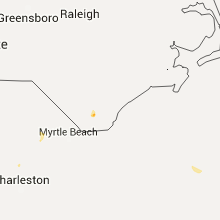
Hail Map for Friday, July 31, 2015

Number of Impacted Households on 7/31/2015
0
Impacted by 1" or Larger Hail
0
Impacted by 1.75" or Larger Hail
0
Impacted by 2.5" or Larger Hail
Square Miles of Populated Area Impacted on 7/31/2015
0
Impacted by 1" or Larger Hail
0
Impacted by 1.75" or Larger Hail
0
Impacted by 2.5" or Larger Hail


Cities Most Affected by Hail Storms of 7/31/2015
| Hail Size | Demographics of Zip Codes Affected | ||||||
|---|---|---|---|---|---|---|---|
| City | Count | Average | Largest | Pop Density | House Value | Income | Age |
| Pilger, NE | 1 | 2.00 | 2.00 | 6 | $52k | $33.2k | 46.9 |
| Sargent, NE | 1 | 1.75 | 1.75 | 2 | $24k | $27.0k | 47.6 |
| Albion, NE | 1 | 1.75 | 1.75 | 9 | $65k | $32.9k | 45.5 |
Hail and Wind Damage Spotted on 7/31/2015
Filter by Report Type:Hail ReportsWind Reports
Georgia
| Local Time | Report Details |
|---|---|
| 3:15 PM EDT | Emergency manager reported 15-20 trees down near highway 19 in dublin and extending into parts of east dubli in laurens county GA, 71.3 miles N of Douglas, GA |
| 4:35 PM EDT | 911 call center has received reports of at least 5 trees down across the county. radar imagery reveals most likely impacted areas were marion and locations just wes in twiggs county GA, 86.7 miles NNW of Douglas, GA |
| 5:10 PM EDT | 911 call center received report of 1 tree and 1 powerline down on highway 230 west located just west of downtown hawkinsville in pulaski county GA, 64.6 miles NW of Douglas, GA |
| 6:05 PM EDT | 911 call center received report of a tree down on cemetary road just off of highway 257 and another tree down on frontage road very near cordel in crisp county GA, 63.1 miles WNW of Douglas, GA |
Nebraska
| Local Time | Report Details |
|---|---|
| 2:35 PM CDT | Golf Ball sized hail reported near Albion, NE, 57.1 miles NNE of Grand Island, NE |
| 2:40 PM CDT | Substantial crop damage in the are in boone county NE, 54.8 miles NNE of Grand Island, NE |
| 2:45 PM CDT | Quarter sized hail reported near Albion, NE, 55.7 miles NNE of Grand Island, NE, some pea to quarter size hail in town. |
| 4:55 PM CDT | Report of a pivot overturned in york county NE, 36 miles E of Grand Island, NE |
| 5:02 PM CDT | Quarter sized hail reported near York, NE, 37.2 miles E of Grand Island, NE, heavy rain |
| 5:04 PM CDT | Hen Egg sized hail reported near Pilger, NE, 71.3 miles NW of Omaha, NE, also 40 mph winds. siding destroyed on home. windows knocked out. |
| 5:35 PM CDT | Numerous trees down onto power lines. wind speed uknown. also up to dime size hai in cuming county NE, 56.5 miles NW of Omaha, NE |
| 5:50 PM CDT | Golf Ball sized hail reported near Sargent, NE, 69.3 miles SW of Oneill, NE, est. 50 to 60 mph winds after the hail...tree limbs downed |
| 5:55 PM CDT | 5 inch diameter tree limbs down in merrick county NE, 21.9 miles NE of Grand Island, NE |
| 6:00 PM CDT | Quarter sized hail reported near Oakland, NE, 48.5 miles NW of Omaha, NE, also small tree limbs blown down. |
| 6:11 PM CDT | Tree limbs breakin in burt county NE, 41.9 miles NNW of Omaha, NE |
| 6:35 PM CDT | 6 to 8 inch tree limbs down in custer county NE, 65 miles NW of Grand Island, NE |
| 7:02 PM CDT | Quarter sized hail reported near Henderson, NE, 28.4 miles ESE of Grand Island, NE |
Oklahoma
| Local Time | Report Details |
|---|---|
| 2:35 PM CDT | Relayed by kswo-t in jackson county OK, 59.5 miles ENE of Childress, TX |
| 4:10 PM CDT | Small to medium sized tree branches dow in tillman county OK, 28.4 miles NNW of Wichita Falls, TX |
| 4:20 PM CDT | Snapped power lines on hwy 58 and cr 105 in caddo county OK, 59.8 miles W of Oklahoma City, OK |
Florida
| Local Time | Report Details |
|---|---|
| 3:38 PM EDT | Weatherbug mesonet site wstnn at cypress bay high school reported a wind gust of 59 mph at 338 pm ed in broward county FL, 25.6 miles NNW of Miami, FL |
| 5:05 PM EDT | Several downed tree limbs 3-4 inches in diameter near the interchange of fl874 and sw 104th stree in miami-dade county FL, 9.2 miles WSW of Miami, FL |
| 5:14 PM EDT | Powerlines down at us1 and beach road. report relayed via broadcast medi in palm beach county FL, 28 miles SE of Port Saint Lucie, FL |
| 3:56 AM EDT | Earth networks site at marco island reported 58 mph wind gust. the site is elevated on top of a 12-story buildin in collier county FL, 15 miles SSE of Naples, FL |
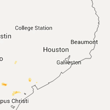
Texas
| Local Time | Report Details |
|---|---|
| 2:55 PM CDT | Storm damage reported in wilbarger county TX, 49.9 miles WNW of Wichita Falls, TX |
| 6:41 PM CDT | Large carport blown onto power lines and power poles blown onto road near intersection of staples and ayers. time estimated from rada in nueces county TX, 1.8 miles S of Corpus Christi, TX |
| 9:15 PM CDT | Report via west texas mesone in deaf smith county TX, 42.6 miles SW of Amarillo, TX |
| 9:58 PM CDT | Report received via kvii schoolne in deaf smith county TX, 27.3 miles SW of Amarillo, TX |
Arizona
| Local Time | Report Details |
|---|---|
| 1:40 PM MST | Delayed report...department of public safety reports power poles down near sr88 and tomohawk. salt river project utililty reported 12 poles blown down along apache trai in pinal county AZ, 31.6 miles E of Phoenix, AZ |
| 1:45 PM MST | Damage to windsong mobile home par in pinal county AZ, 29.2 miles E of Phoenix, AZ |
| 4:00 PM MST | Power poles blown down in maricopa county AZ, 12.5 miles N of Phoenix, AZ |
| 4:39 PM MST | Department of public safety reports power poles down near sr88 and tomahaw in pinal county AZ, 31.6 miles E of Phoenix, AZ |
Missouri
| Local Time | Report Details |
|---|---|
| 8:52 PM CDT | Tree and light pole down in ravenwoo in nodaway county MO, 86.2 miles N of Kansas City, MO |
Iowa
| Local Time | Report Details |
|---|---|
| 11:15 PM CDT | Half Dollar sized hail reported near Kellerton, IA, 64.8 miles SSW of Des Moines, IA, hail up to 1.25 inch for several minutes. hail preceded rain and continued with rain. |
New York
| Local Time | Report Details |
|---|---|
| 3:22 AM EDT | Wires dow in lewis county NY, 55.1 miles NE of Syracuse, NY |
Connect with Interactive Hail Maps