

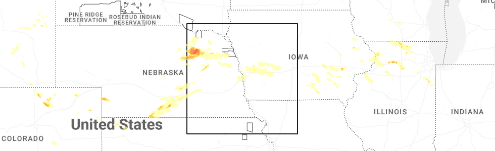
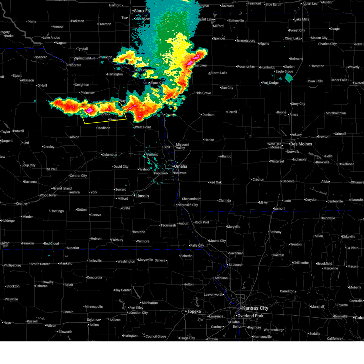
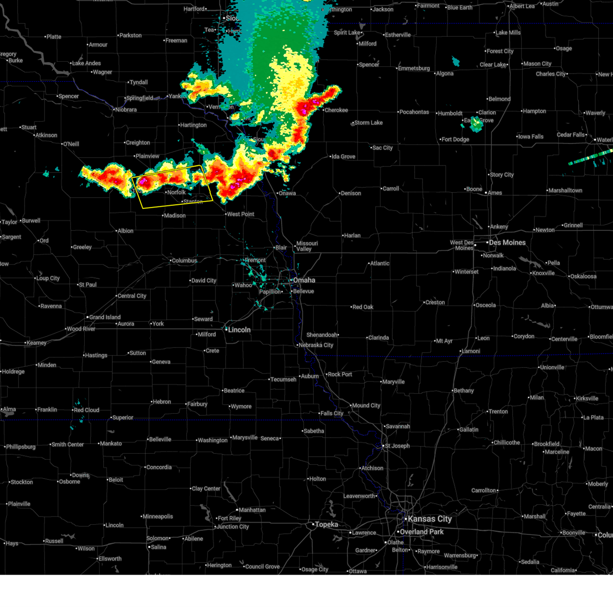
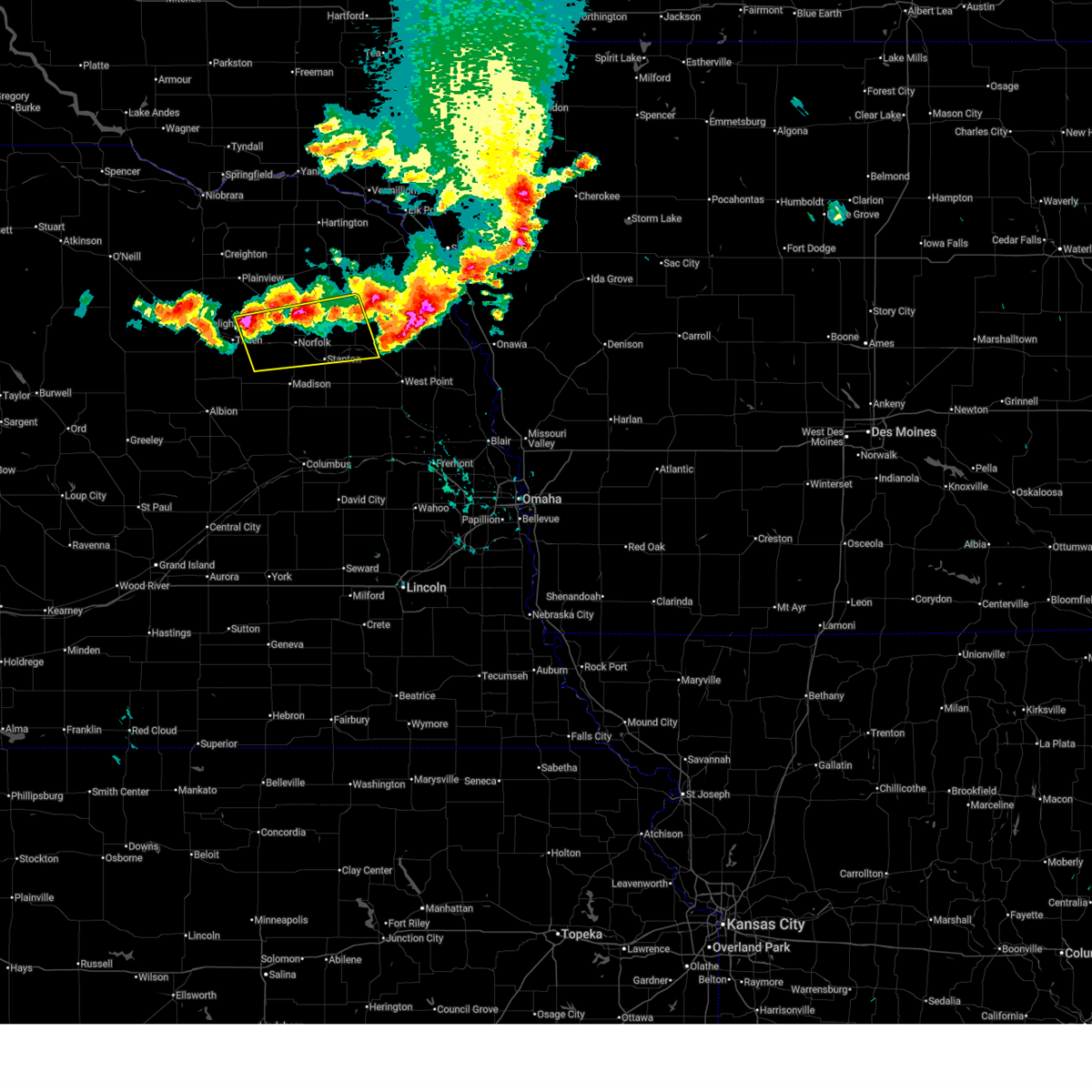
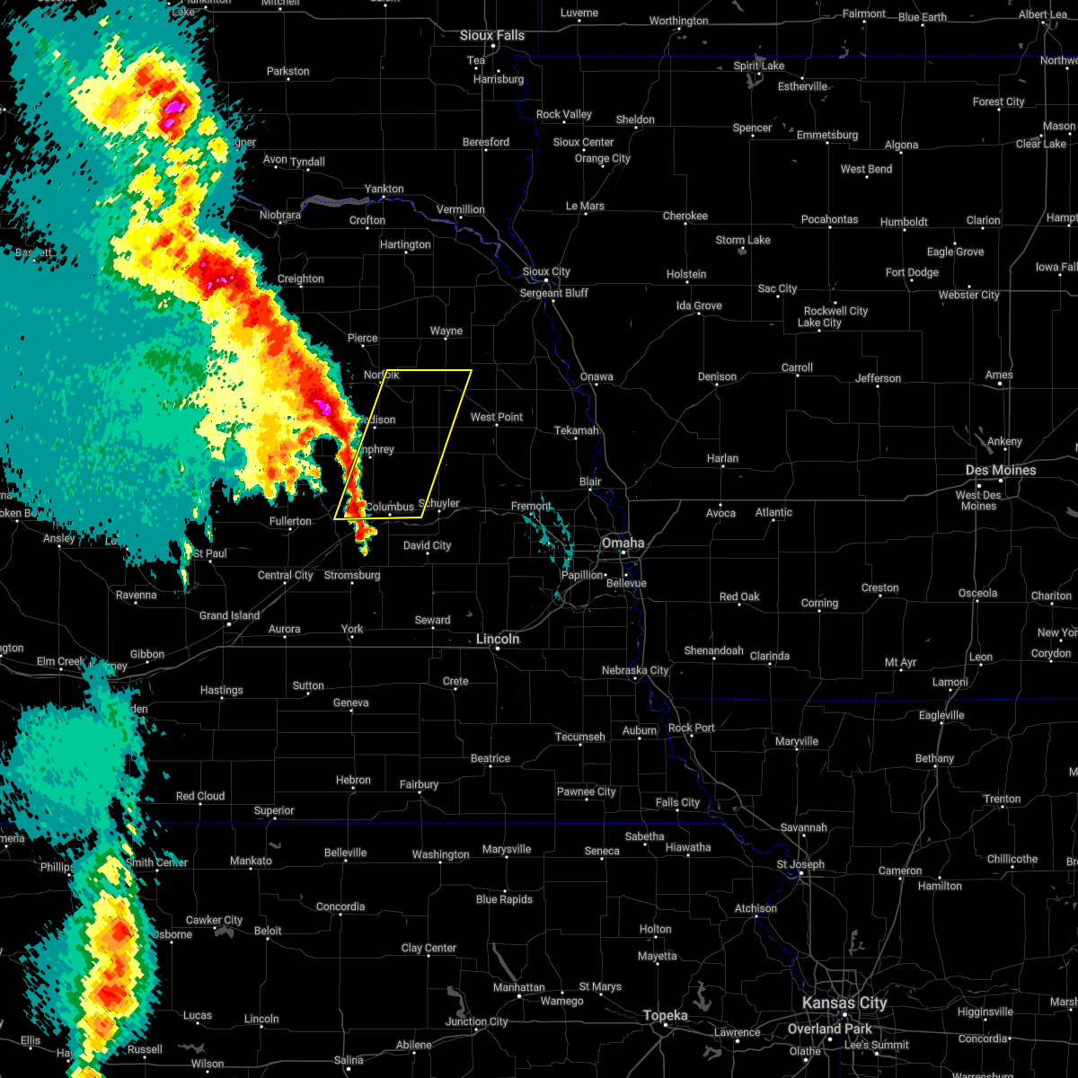
Hail Map for Pilger, NE
The Pilger, NE area has had 5 reports of on-the-ground hail by trained spotters, and has been under severe weather warnings 11 times during the past 12 months. Doppler radar has detected hail at or near Pilger, NE on 80 occasions, including 4 occasions during the past year.
| Name: | Pilger, NE |
| Where Located: | 77.4 miles NW of Omaha, NE |
| Map: | Google Map for Pilger, NE |
| Population: | 352 |
| Housing Units: | 186 |
| More Info: | Search Google for Pilger, NE |
2
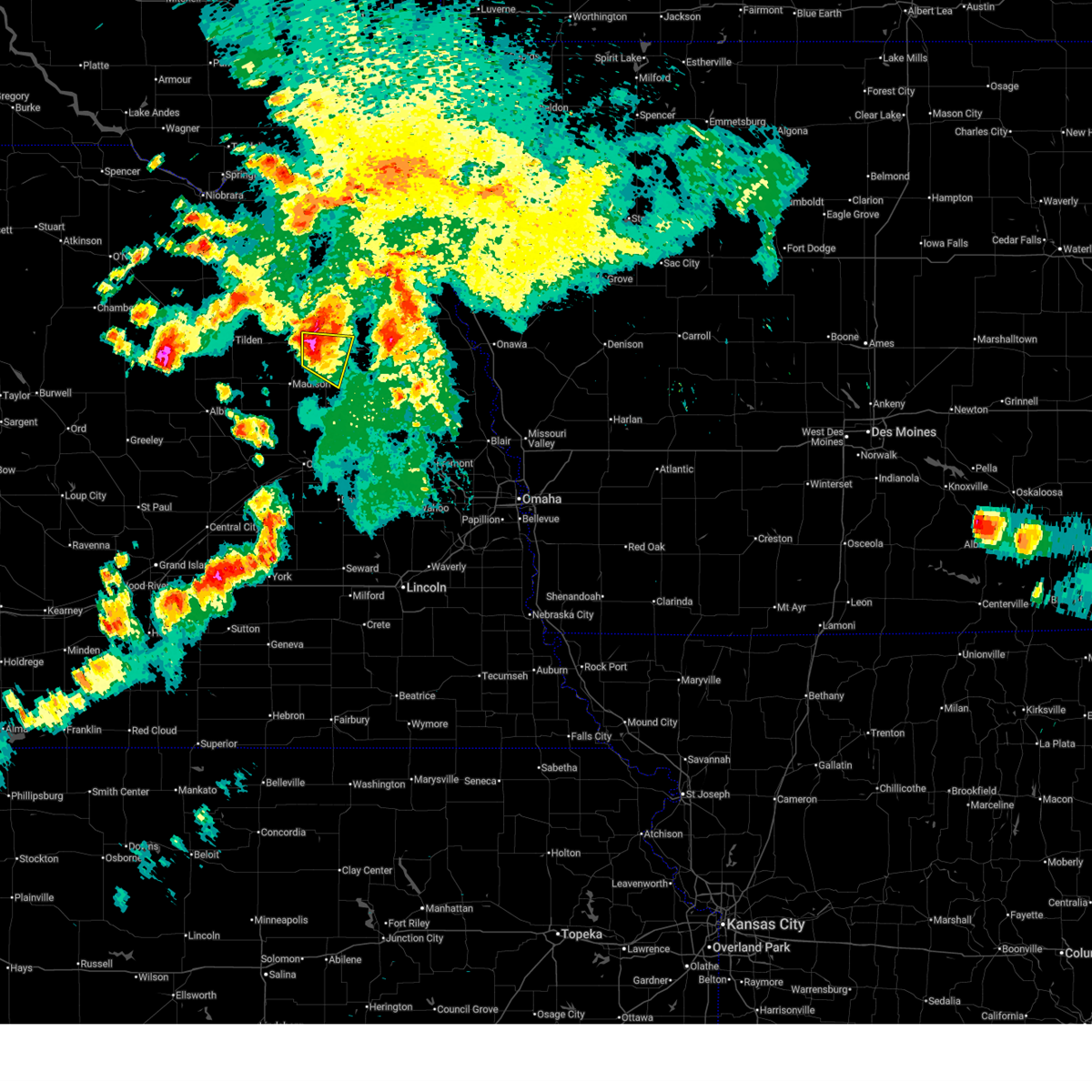
The Top Recent Hail Date for Pilger, NE is Thursday, July 10, 2025 (16th out of 80)
Hail and Wind Damage Spotted near Pilger, NE
| Date / Time | Report Details |
|---|---|
| 7/10/2025 7:43 PM CDT | the severe thunderstorm warning has been cancelled and is no longer in effect |
| 7/10/2025 7:28 PM CDT |
 At 728 pm cdt, a severe thunderstorm was located 5 miles northwest of stanton, or 6 miles southeast of norfolk, moving east at 25 mph (weather instrument measurement). Hazards include 60 mph wind gusts and quarter size hail. Hail damage to vehicles is expected. expect wind damage to roofs, siding, and trees. this severe storm will be near, stanton around 735 pm cdt. Other locations in the path of this severe thunderstorm include pilger. At 728 pm cdt, a severe thunderstorm was located 5 miles northwest of stanton, or 6 miles southeast of norfolk, moving east at 25 mph (weather instrument measurement). Hazards include 60 mph wind gusts and quarter size hail. Hail damage to vehicles is expected. expect wind damage to roofs, siding, and trees. this severe storm will be near, stanton around 735 pm cdt. Other locations in the path of this severe thunderstorm include pilger.
|
| 7/10/2025 7:28 PM CDT |
 the severe thunderstorm warning has been cancelled and is no longer in effect the severe thunderstorm warning has been cancelled and is no longer in effect
|
| 7/10/2025 7:17 PM CDT | At 715 pm cdt, a severe thunderstorm was located near norfolk, moving east at 25 mph (weather instrument measurement of 63 mph at norfolk airport at 709 pm). Hazards include 60 mph wind gusts and quarter size hail. Hail damage to vehicles is expected. expect wind damage to roofs, siding, and trees. this severe storm will be near, stanton around 730 pm cdt. Other locations in the path of this severe thunderstorm include pilger. |
| 7/10/2025 7:11 PM CDT | Svroax the national weather service in omaha has issued a * severe thunderstorm warning for, northeastern madison county in northeastern nebraska, central stanton county in northeastern nebraska, * until 800 pm cdt. * at 711 pm cdt, a severe thunderstorm was located near norfolk, moving east at 25 mph (radar indicated). Hazards include 60 mph wind gusts and quarter size hail. Hail damage to vehicles is expected. expect wind damage to roofs, siding, and trees. this severe thunderstorm will be near, norfolk around 715 pm cdt. Stanton around 725 pm cdt. |
| 7/7/2025 8:54 PM CDT |
 At 853 pm cdt, severe thunderstorms were located along a line extending from 5 miles south of smithland to 4 miles west of lyons to 6 miles north of clarkson, moving southeast at 30 mph (radar indicated). Hazards include 60 mph wind gusts and quarter size hail. Hail damage to vehicles is expected. expect wind damage to roofs, siding, and trees. Locations impacted include, west point, onawa, oakland, lyons, clarkson, howells, decatur, castana, dodge, blencoe, snyder, craig, soldier, uehling and moorhead. At 853 pm cdt, severe thunderstorms were located along a line extending from 5 miles south of smithland to 4 miles west of lyons to 6 miles north of clarkson, moving southeast at 30 mph (radar indicated). Hazards include 60 mph wind gusts and quarter size hail. Hail damage to vehicles is expected. expect wind damage to roofs, siding, and trees. Locations impacted include, west point, onawa, oakland, lyons, clarkson, howells, decatur, castana, dodge, blencoe, snyder, craig, soldier, uehling and moorhead.
|
| 7/7/2025 8:36 PM CDT |
 Svroax the national weather service in omaha has issued a * severe thunderstorm warning for, monona county in west central iowa, northwestern harrison county in southwestern iowa, burt county in east central nebraska, cuming county in northeastern nebraska, southern wayne county in northeastern nebraska, northeastern colfax county in northeastern nebraska, northwestern dodge county in east central nebraska, thurston county in northeastern nebraska, stanton county in northeastern nebraska, * until 915 pm cdt. * at 836 pm cdt, severe thunderstorms were located along a line extending from 5 miles northwest of smithland to 4 miles southeast of pender to 3 miles west of stanton, moving southeast at 30 mph (radar indicated). Hazards include 60 mph wind gusts and quarter size hail. Hail damage to vehicles is expected. expect wind damage to roofs, siding, and trees. severe thunderstorms will be near, wisner, whiting, beemer, bancroft, rosalie, and macy around 840 pm cdt. lyons and decatur around 850 pm cdt. west point and onawa around 855 pm cdt. other locations in the path of these severe thunderstorms include clarkson, castana, oakland and howells. This includes interstate 29 between mile markers 99 and 125. Svroax the national weather service in omaha has issued a * severe thunderstorm warning for, monona county in west central iowa, northwestern harrison county in southwestern iowa, burt county in east central nebraska, cuming county in northeastern nebraska, southern wayne county in northeastern nebraska, northeastern colfax county in northeastern nebraska, northwestern dodge county in east central nebraska, thurston county in northeastern nebraska, stanton county in northeastern nebraska, * until 915 pm cdt. * at 836 pm cdt, severe thunderstorms were located along a line extending from 5 miles northwest of smithland to 4 miles southeast of pender to 3 miles west of stanton, moving southeast at 30 mph (radar indicated). Hazards include 60 mph wind gusts and quarter size hail. Hail damage to vehicles is expected. expect wind damage to roofs, siding, and trees. severe thunderstorms will be near, wisner, whiting, beemer, bancroft, rosalie, and macy around 840 pm cdt. lyons and decatur around 850 pm cdt. west point and onawa around 855 pm cdt. other locations in the path of these severe thunderstorms include clarkson, castana, oakland and howells. This includes interstate 29 between mile markers 99 and 125.
|
| 6/16/2025 5:56 PM CDT | At 556 pm cdt, severe thunderstorms were located along a line extending from 6 miles northwest of pilger to 4 miles northeast of battle creek, moving east at 25 mph (radar indicated). Hazards include 60 mph wind gusts and quarter size hail. Hail damage to vehicles is expected. expect wind damage to roofs, siding, and trees. these severe storms will be near, norfolk and pilger around 600 pm cdt. Other locations in the path of these severe thunderstorms include stanton. |
| 6/16/2025 5:46 PM CDT |
 At 545 pm cdt, severe thunderstorms were located along a line extending from 5 miles east of hoskins to 5 miles north of battle creek, moving east at 25 mph (radar indicated). Hazards include 60 mph wind gusts and half dollar size hail. Hail damage to vehicles is expected. expect wind damage to roofs, siding, and trees. these severe storms will be near, norfolk, hadar, and hoskins around 550 pm cdt. Other locations in the path of these severe thunderstorms include pilger, stanton and wisner. At 545 pm cdt, severe thunderstorms were located along a line extending from 5 miles east of hoskins to 5 miles north of battle creek, moving east at 25 mph (radar indicated). Hazards include 60 mph wind gusts and half dollar size hail. Hail damage to vehicles is expected. expect wind damage to roofs, siding, and trees. these severe storms will be near, norfolk, hadar, and hoskins around 550 pm cdt. Other locations in the path of these severe thunderstorms include pilger, stanton and wisner.
|
| 6/16/2025 5:36 PM CDT |
 At 535 pm cdt, severe thunderstorms were located along a line extending from 2 miles north of hoskins to 6 miles north of meadow grove, moving southeast at 25 mph (radar indicated). Hazards include 60 mph wind gusts and half dollar size hail. Hail damage to vehicles is expected. expect wind damage to roofs, siding, and trees. these severe storms will be near, norfolk, hadar, and hoskins around 540 pm cdt. Other locations in the path of these severe thunderstorms include pilger and wisner. At 535 pm cdt, severe thunderstorms were located along a line extending from 2 miles north of hoskins to 6 miles north of meadow grove, moving southeast at 25 mph (radar indicated). Hazards include 60 mph wind gusts and half dollar size hail. Hail damage to vehicles is expected. expect wind damage to roofs, siding, and trees. these severe storms will be near, norfolk, hadar, and hoskins around 540 pm cdt. Other locations in the path of these severe thunderstorms include pilger and wisner.
|
| 6/16/2025 5:26 PM CDT |
 Svroax the national weather service in omaha has issued a * severe thunderstorm warning for, northern madison county in northeastern nebraska, northwestern cuming county in northeastern nebraska, southwestern wayne county in northeastern nebraska, southern pierce county in northeastern nebraska, northern stanton county in northeastern nebraska, * until 615 pm cdt. * at 525 pm cdt, severe thunderstorms were located along a line extending from 6 miles north of hoskins to 7 miles northeast of tilden, moving east at 25 mph (radar indicated). Hazards include 60 mph wind gusts and quarter size hail. Hail damage to vehicles is expected. expect wind damage to roofs, siding, and trees. severe thunderstorms will be near, pierce and hadar around 530 pm cdt. winside and hoskins around 535 pm cdt. Norfolk around 545 pm cdt. Svroax the national weather service in omaha has issued a * severe thunderstorm warning for, northern madison county in northeastern nebraska, northwestern cuming county in northeastern nebraska, southwestern wayne county in northeastern nebraska, southern pierce county in northeastern nebraska, northern stanton county in northeastern nebraska, * until 615 pm cdt. * at 525 pm cdt, severe thunderstorms were located along a line extending from 6 miles north of hoskins to 7 miles northeast of tilden, moving east at 25 mph (radar indicated). Hazards include 60 mph wind gusts and quarter size hail. Hail damage to vehicles is expected. expect wind damage to roofs, siding, and trees. severe thunderstorms will be near, pierce and hadar around 530 pm cdt. winside and hoskins around 535 pm cdt. Norfolk around 545 pm cdt.
|
| 6/25/2024 8:31 PM CDT |
 the severe thunderstorm warning has been cancelled and is no longer in effect the severe thunderstorm warning has been cancelled and is no longer in effect
|
| 6/25/2024 8:18 PM CDT |
 At 818 pm cdt, a severe thunderstorm was located 7 miles north of pilger, or 8 miles south of wayne, moving east at 25 mph (radar indicated). Hazards include 60 mph wind gusts and quarter size hail. Hail damage to vehicles is expected. expect wind damage to roofs, siding, and trees. Locations impacted include, wisner, pilger, winnebago reservation, and omaha reservation. At 818 pm cdt, a severe thunderstorm was located 7 miles north of pilger, or 8 miles south of wayne, moving east at 25 mph (radar indicated). Hazards include 60 mph wind gusts and quarter size hail. Hail damage to vehicles is expected. expect wind damage to roofs, siding, and trees. Locations impacted include, wisner, pilger, winnebago reservation, and omaha reservation.
|
| 6/25/2024 8:06 PM CDT |
 Svroax the national weather service in omaha has issued a * severe thunderstorm warning for, southeastern wayne county in northeastern nebraska, northwestern cuming county in northeastern nebraska, west central thurston county in northeastern nebraska, northeastern stanton county in northeastern nebraska, * until 845 pm cdt. * at 806 pm cdt, a severe thunderstorm was located 4 miles southeast of winside, or 7 miles southwest of wayne, moving east at 30 mph (radar indicated). Hazards include 60 mph wind gusts and quarter size hail. Hail damage to vehicles is expected. Expect wind damage to roofs, siding, and trees. Svroax the national weather service in omaha has issued a * severe thunderstorm warning for, southeastern wayne county in northeastern nebraska, northwestern cuming county in northeastern nebraska, west central thurston county in northeastern nebraska, northeastern stanton county in northeastern nebraska, * until 845 pm cdt. * at 806 pm cdt, a severe thunderstorm was located 4 miles southeast of winside, or 7 miles southwest of wayne, moving east at 30 mph (radar indicated). Hazards include 60 mph wind gusts and quarter size hail. Hail damage to vehicles is expected. Expect wind damage to roofs, siding, and trees.
|
| 6/15/2024 7:39 PM CDT |
 the severe thunderstorm warning has been cancelled and is no longer in effect the severe thunderstorm warning has been cancelled and is no longer in effect
|
| 6/15/2024 7:24 PM CDT |
 Svroax the national weather service in omaha has issued a * severe thunderstorm warning for, southeastern wayne county in northeastern nebraska, northwestern cuming county in northeastern nebraska, northeastern stanton county in northeastern nebraska, * until 800 pm cdt. * at 724 pm cdt, a severe thunderstorm was located over pilger, or 16 miles south of wayne, moving northeast at 35 mph (radar indicated). Hazards include quarter size hail. damage to vehicles is expected Svroax the national weather service in omaha has issued a * severe thunderstorm warning for, southeastern wayne county in northeastern nebraska, northwestern cuming county in northeastern nebraska, northeastern stanton county in northeastern nebraska, * until 800 pm cdt. * at 724 pm cdt, a severe thunderstorm was located over pilger, or 16 miles south of wayne, moving northeast at 35 mph (radar indicated). Hazards include quarter size hail. damage to vehicles is expected
|
| 6/15/2024 7:05 PM CDT |
 At 705 pm cdt, severe thunderstorms were located along a line extending from 4 miles south of wayne to 3 miles north of stanton to 9 miles northeast of newman grove, moving east at 10 mph (radar indicated). Hazards include ping pong ball size hail and 60 mph wind gusts. People and animals outdoors will be injured. expect hail damage to roofs, siding, windows, and vehicles. expect wind damage to roofs, siding, and trees. Locations impacted include, norfolk, wayne, stanton, pilger, and lake maskenthine recreation area. At 705 pm cdt, severe thunderstorms were located along a line extending from 4 miles south of wayne to 3 miles north of stanton to 9 miles northeast of newman grove, moving east at 10 mph (radar indicated). Hazards include ping pong ball size hail and 60 mph wind gusts. People and animals outdoors will be injured. expect hail damage to roofs, siding, windows, and vehicles. expect wind damage to roofs, siding, and trees. Locations impacted include, norfolk, wayne, stanton, pilger, and lake maskenthine recreation area.
|
| 6/15/2024 7:05 PM CDT |
 the severe thunderstorm warning has been cancelled and is no longer in effect the severe thunderstorm warning has been cancelled and is no longer in effect
|
| 6/15/2024 6:53 PM CDT |
 At 653 pm cdt, a severe thunderstorm capable of producing a tornado was located over pilger, or 14 miles south of wayne, moving northeast at 25 mph (radar indicated rotation). Hazards include tornado. Flying debris will be dangerous to those caught without shelter. mobile homes will be damaged or destroyed. damage to roofs, windows, and vehicles will occur. tree damage is likely. This tornadic thunderstorm will remain over mainly rural areas of southeastern wayne, northwestern cuming and northeastern stanton counties. At 653 pm cdt, a severe thunderstorm capable of producing a tornado was located over pilger, or 14 miles south of wayne, moving northeast at 25 mph (radar indicated rotation). Hazards include tornado. Flying debris will be dangerous to those caught without shelter. mobile homes will be damaged or destroyed. damage to roofs, windows, and vehicles will occur. tree damage is likely. This tornadic thunderstorm will remain over mainly rural areas of southeastern wayne, northwestern cuming and northeastern stanton counties.
|
| 6/15/2024 6:42 PM CDT |
 Toroax the national weather service in omaha has issued a * tornado warning for, southeastern wayne county in northeastern nebraska, northwestern cuming county in northeastern nebraska, northeastern stanton county in northeastern nebraska, * until 715 pm cdt. * at 642 pm cdt, a severe thunderstorm capable of producing a tornado was located near pilger, or 17 miles east of norfolk, moving northeast at 30 mph (radar indicated rotation). Hazards include tornado. Flying debris will be dangerous to those caught without shelter. mobile homes will be damaged or destroyed. damage to roofs, windows, and vehicles will occur. tree damage is likely. This dangerous storm will be near, pilger around 645 pm cdt. Toroax the national weather service in omaha has issued a * tornado warning for, southeastern wayne county in northeastern nebraska, northwestern cuming county in northeastern nebraska, northeastern stanton county in northeastern nebraska, * until 715 pm cdt. * at 642 pm cdt, a severe thunderstorm capable of producing a tornado was located near pilger, or 17 miles east of norfolk, moving northeast at 30 mph (radar indicated rotation). Hazards include tornado. Flying debris will be dangerous to those caught without shelter. mobile homes will be damaged or destroyed. damage to roofs, windows, and vehicles will occur. tree damage is likely. This dangerous storm will be near, pilger around 645 pm cdt.
|
| 6/15/2024 6:25 PM CDT |
 Svroax the national weather service in omaha has issued a * severe thunderstorm warning for, central madison county in northeastern nebraska, southeastern wayne county in northeastern nebraska, northwestern cuming county in northeastern nebraska, southeastern pierce county in northeastern nebraska, northern stanton county in northeastern nebraska, * until 730 pm cdt. * at 625 pm cdt, severe thunderstorms were located along a line extending from 2 miles northeast of hoskins to 9 miles north of newman grove, moving east at 25 mph (radar indicated). Hazards include golf ball size hail and 60 mph wind gusts. People and animals outdoors will be injured. expect hail damage to roofs, siding, windows, and vehicles. Expect wind damage to roofs, siding, and trees. Svroax the national weather service in omaha has issued a * severe thunderstorm warning for, central madison county in northeastern nebraska, southeastern wayne county in northeastern nebraska, northwestern cuming county in northeastern nebraska, southeastern pierce county in northeastern nebraska, northern stanton county in northeastern nebraska, * until 730 pm cdt. * at 625 pm cdt, severe thunderstorms were located along a line extending from 2 miles northeast of hoskins to 9 miles north of newman grove, moving east at 25 mph (radar indicated). Hazards include golf ball size hail and 60 mph wind gusts. People and animals outdoors will be injured. expect hail damage to roofs, siding, windows, and vehicles. Expect wind damage to roofs, siding, and trees.
|
| 5/24/2024 1:20 AM CDT |
 Svroax the national weather service in omaha has issued a * severe thunderstorm warning for, northwestern monona county in west central iowa, northwestern burt county in east central nebraska, southeastern wayne county in northeastern nebraska, cuming county in northeastern nebraska, thurston county in northeastern nebraska, central stanton county in northeastern nebraska, * until 200 am cdt. * at 120 am cdt, severe thunderstorms were located along a line extending from 2 miles southwest of wakefield to 4 miles southwest of pilger to 4 miles northeast of creston, moving east at 45 mph (radar indicated). Hazards include 60 mph wind gusts and quarter size hail. Hail damage to vehicles is expected. Expect wind damage to roofs, siding, and trees. Svroax the national weather service in omaha has issued a * severe thunderstorm warning for, northwestern monona county in west central iowa, northwestern burt county in east central nebraska, southeastern wayne county in northeastern nebraska, cuming county in northeastern nebraska, thurston county in northeastern nebraska, central stanton county in northeastern nebraska, * until 200 am cdt. * at 120 am cdt, severe thunderstorms were located along a line extending from 2 miles southwest of wakefield to 4 miles southwest of pilger to 4 miles northeast of creston, moving east at 45 mph (radar indicated). Hazards include 60 mph wind gusts and quarter size hail. Hail damage to vehicles is expected. Expect wind damage to roofs, siding, and trees.
|
| 5/24/2024 12:46 AM CDT |
 Svroax the national weather service in omaha has issued a * severe thunderstorm warning for, madison county in northeastern nebraska, wayne county in northeastern nebraska, northwestern cuming county in northeastern nebraska, southeastern pierce county in northeastern nebraska, northwestern thurston county in northeastern nebraska, southeastern cedar county in northeastern nebraska, stanton county in northeastern nebraska, * until 130 am cdt. * at 1246 am cdt, severe thunderstorms were located along a line extending from 2 miles northeast of belden to 3 miles east of hadar to 5 miles northeast of newman grove, moving east at 35 mph (radar indicated). Hazards include 60 mph wind gusts and quarter size hail. Hail damage to vehicles is expected. Expect wind damage to roofs, siding, and trees. Svroax the national weather service in omaha has issued a * severe thunderstorm warning for, madison county in northeastern nebraska, wayne county in northeastern nebraska, northwestern cuming county in northeastern nebraska, southeastern pierce county in northeastern nebraska, northwestern thurston county in northeastern nebraska, southeastern cedar county in northeastern nebraska, stanton county in northeastern nebraska, * until 130 am cdt. * at 1246 am cdt, severe thunderstorms were located along a line extending from 2 miles northeast of belden to 3 miles east of hadar to 5 miles northeast of newman grove, moving east at 35 mph (radar indicated). Hazards include 60 mph wind gusts and quarter size hail. Hail damage to vehicles is expected. Expect wind damage to roofs, siding, and trees.
|
| 5/21/2024 5:56 AM CDT |
 The storms which prompted the warning have moved out of the area. therefore, the warning will be allowed to expire. a severe thunderstorm watch remains in effect until 700 am cdt for northeastern nebraska. The storms which prompted the warning have moved out of the area. therefore, the warning will be allowed to expire. a severe thunderstorm watch remains in effect until 700 am cdt for northeastern nebraska.
|
| 5/21/2024 5:25 AM CDT |
 At 525 am cdt, severe thunderstorms were located along a line extending from 4 miles southeast of norfolk to 3 miles southeast of clarkson, moving northeast at 60 mph (radar indicated). Hazards include 60 mph wind gusts. Expect damage to roofs, siding, and trees. Locations impacted include, west point, stanton, wisner, beemer, clarkson, howells, leigh, pilger, the highway 15 and 32 junction, the highway 57 and 32 junction, aloys, lake maskenthine recreation area, and maple creek recreation area. At 525 am cdt, severe thunderstorms were located along a line extending from 4 miles southeast of norfolk to 3 miles southeast of clarkson, moving northeast at 60 mph (radar indicated). Hazards include 60 mph wind gusts. Expect damage to roofs, siding, and trees. Locations impacted include, west point, stanton, wisner, beemer, clarkson, howells, leigh, pilger, the highway 15 and 32 junction, the highway 57 and 32 junction, aloys, lake maskenthine recreation area, and maple creek recreation area.
|
| 5/21/2024 5:25 AM CDT |
 the severe thunderstorm warning has been cancelled and is no longer in effect the severe thunderstorm warning has been cancelled and is no longer in effect
|
| 5/21/2024 5:10 AM CDT |
 Svroax the national weather service in omaha has issued a * severe thunderstorm warning for, southeastern madison county in northeastern nebraska, south central wayne county in northeastern nebraska, western cuming county in northeastern nebraska, northwestern colfax county in northeastern nebraska, northeastern platte county in northeastern nebraska, stanton county in northeastern nebraska, * until 600 am cdt. * at 510 am cdt, severe thunderstorms were located along a line extending from 4 miles west of madison to near lakeview, moving east at 45 mph (radar indicated). Hazards include 60 mph wind gusts. expect damage to roofs, siding, and trees Svroax the national weather service in omaha has issued a * severe thunderstorm warning for, southeastern madison county in northeastern nebraska, south central wayne county in northeastern nebraska, western cuming county in northeastern nebraska, northwestern colfax county in northeastern nebraska, northeastern platte county in northeastern nebraska, stanton county in northeastern nebraska, * until 600 am cdt. * at 510 am cdt, severe thunderstorms were located along a line extending from 4 miles west of madison to near lakeview, moving east at 45 mph (radar indicated). Hazards include 60 mph wind gusts. expect damage to roofs, siding, and trees
|
| 4/30/2024 7:35 AM CDT |
 the severe thunderstorm warning has been cancelled and is no longer in effect the severe thunderstorm warning has been cancelled and is no longer in effect
|
| 4/30/2024 7:19 AM CDT |
 Svroax the national weather service in omaha has issued a * severe thunderstorm warning for, southeastern wayne county in northeastern nebraska, northwestern cuming county in northeastern nebraska, east central stanton county in northeastern nebraska, * until 800 am cdt. * at 719 am cdt, a severe thunderstorm was located 8 miles southeast of stanton, or 20 miles west of west point, moving northeast at 30 mph (radar indicated). Hazards include quarter size hail. damage to vehicles is expected Svroax the national weather service in omaha has issued a * severe thunderstorm warning for, southeastern wayne county in northeastern nebraska, northwestern cuming county in northeastern nebraska, east central stanton county in northeastern nebraska, * until 800 am cdt. * at 719 am cdt, a severe thunderstorm was located 8 miles southeast of stanton, or 20 miles west of west point, moving northeast at 30 mph (radar indicated). Hazards include quarter size hail. damage to vehicles is expected
|
| 4/26/2024 4:58 PM CDT |
 the severe thunderstorm warning has been cancelled and is no longer in effect the severe thunderstorm warning has been cancelled and is no longer in effect
|
| 4/26/2024 4:55 PM CDT |
 the severe thunderstorm warning has been cancelled and is no longer in effect the severe thunderstorm warning has been cancelled and is no longer in effect
|
| 4/26/2024 4:42 PM CDT |
 At 442 pm cdt, a severe thunderstorm was located 3 miles south of leigh, or 15 miles north of columbus, moving north at 45 mph (radar indicated). Hazards include 60 mph wind gusts and quarter size hail. Hail damage to vehicles is expected. expect wind damage to roofs, siding, and trees. Locations impacted include, norfolk, stanton, clarkson, leigh, pilger, creston, the highway 15 and 32 junction, the highway 57 and 32 junction, lake maskenthine recreation area, and maple creek recreation area. At 442 pm cdt, a severe thunderstorm was located 3 miles south of leigh, or 15 miles north of columbus, moving north at 45 mph (radar indicated). Hazards include 60 mph wind gusts and quarter size hail. Hail damage to vehicles is expected. expect wind damage to roofs, siding, and trees. Locations impacted include, norfolk, stanton, clarkson, leigh, pilger, creston, the highway 15 and 32 junction, the highway 57 and 32 junction, lake maskenthine recreation area, and maple creek recreation area.
|
| 4/26/2024 4:42 PM CDT |
 the severe thunderstorm warning has been cancelled and is no longer in effect the severe thunderstorm warning has been cancelled and is no longer in effect
|
| 4/26/2024 4:42 PM CDT |
 Svroax the national weather service in omaha has issued a * severe thunderstorm warning for, southeastern madison county in northeastern nebraska, northwestern colfax county in northeastern nebraska, northeastern platte county in northeastern nebraska, stanton county in northeastern nebraska, * until 530 pm cdt. * at 441 pm cdt, a severe thunderstorm was located 4 miles south of leigh, or 15 miles north of columbus, moving north at 45 mph (radar indicated). Hazards include 60 mph wind gusts and quarter size hail. Hail damage to vehicles is expected. Expect wind damage to roofs, siding, and trees. Svroax the national weather service in omaha has issued a * severe thunderstorm warning for, southeastern madison county in northeastern nebraska, northwestern colfax county in northeastern nebraska, northeastern platte county in northeastern nebraska, stanton county in northeastern nebraska, * until 530 pm cdt. * at 441 pm cdt, a severe thunderstorm was located 4 miles south of leigh, or 15 miles north of columbus, moving north at 45 mph (radar indicated). Hazards include 60 mph wind gusts and quarter size hail. Hail damage to vehicles is expected. Expect wind damage to roofs, siding, and trees.
|
| 4/26/2024 4:40 PM CDT |
 Svroax the national weather service in omaha has issued a * severe thunderstorm warning for, eastern madison county in northeastern nebraska, northwestern colfax county in northeastern nebraska, northeastern platte county in northeastern nebraska, southeastern pierce county in northeastern nebraska, stanton county in northeastern nebraska, * until 530 pm cdt. * at 440 pm cdt, a severe thunderstorm was located 5 miles south of leigh, or 14 miles north of columbus, moving north at 45 mph (radar indicated). Hazards include 60 mph wind gusts and quarter size hail. Hail damage to vehicles is expected. Expect wind damage to roofs, siding, and trees. Svroax the national weather service in omaha has issued a * severe thunderstorm warning for, eastern madison county in northeastern nebraska, northwestern colfax county in northeastern nebraska, northeastern platte county in northeastern nebraska, southeastern pierce county in northeastern nebraska, stanton county in northeastern nebraska, * until 530 pm cdt. * at 440 pm cdt, a severe thunderstorm was located 5 miles south of leigh, or 14 miles north of columbus, moving north at 45 mph (radar indicated). Hazards include 60 mph wind gusts and quarter size hail. Hail damage to vehicles is expected. Expect wind damage to roofs, siding, and trees.
|
| 4/16/2024 8:53 AM CDT |
 the tornado warning has been cancelled and is no longer in effect the tornado warning has been cancelled and is no longer in effect
|
| 4/16/2024 8:39 AM CDT |
 Toroax the national weather service in omaha has issued a * tornado warning for, northeastern stanton county in northeastern nebraska, * until 930 am cdt. * at 839 am cdt, a severe thunderstorm capable of producing a tornado was located 3 miles south of stanton, or 14 miles southeast of norfolk, moving north at 45 mph (radar indicated rotation). Hazards include tornado and quarter size hail. Flying debris will be dangerous to those caught without shelter. mobile homes will be damaged or destroyed. damage to roofs, windows, and vehicles will occur. tree damage is likely. This dangerous storm will be near, stanton around 845 am cdt. Toroax the national weather service in omaha has issued a * tornado warning for, northeastern stanton county in northeastern nebraska, * until 930 am cdt. * at 839 am cdt, a severe thunderstorm capable of producing a tornado was located 3 miles south of stanton, or 14 miles southeast of norfolk, moving north at 45 mph (radar indicated rotation). Hazards include tornado and quarter size hail. Flying debris will be dangerous to those caught without shelter. mobile homes will be damaged or destroyed. damage to roofs, windows, and vehicles will occur. tree damage is likely. This dangerous storm will be near, stanton around 845 am cdt.
|
| 4/1/2024 4:15 AM CDT | About 1/2 mile of power lines blown dow in stanton county NE, 9.4 miles N of Pilger, NE |
| 4/1/2024 4:04 AM CDT |
 Svroax the national weather service in omaha has issued a * severe thunderstorm warning for, northern cuming county in northeastern nebraska, central stanton county in northeastern nebraska, * until 445 am cdt. * at 403 am cdt, a severe thunderstorm was located near stanton, or 12 miles southeast of norfolk, moving east at 50 mph (radar indicated). Hazards include quarter size hail. damage to vehicles is expected Svroax the national weather service in omaha has issued a * severe thunderstorm warning for, northern cuming county in northeastern nebraska, central stanton county in northeastern nebraska, * until 445 am cdt. * at 403 am cdt, a severe thunderstorm was located near stanton, or 12 miles southeast of norfolk, moving east at 50 mph (radar indicated). Hazards include quarter size hail. damage to vehicles is expected
|
| 10/3/2023 7:46 PM CDT |
 At 746 pm cdt, severe thunderstorms were located along a line extending from 4 miles northwest of winside to 7 miles south of wayne to 5 miles southwest of wisner, moving northeast at 65 mph (radar indicated). Hazards include 60 mph wind gusts. Expect damage to roofs, siding, and trees. locations impacted include, wayne, wakefield, wisner, pender, laurel, emerson, winnebago, winside, pilger, carroll, thurston, belden, winnebago reservation, and omaha reservation. hail threat, radar indicated max hail size, <. 75 in wind threat, observed max wind gust, 60 mph. At 746 pm cdt, severe thunderstorms were located along a line extending from 4 miles northwest of winside to 7 miles south of wayne to 5 miles southwest of wisner, moving northeast at 65 mph (radar indicated). Hazards include 60 mph wind gusts. Expect damage to roofs, siding, and trees. locations impacted include, wayne, wakefield, wisner, pender, laurel, emerson, winnebago, winside, pilger, carroll, thurston, belden, winnebago reservation, and omaha reservation. hail threat, radar indicated max hail size, <. 75 in wind threat, observed max wind gust, 60 mph.
|
| 10/3/2023 7:40 PM CDT | Tree down across roa in stanton county NE, 3.7 miles ESE of Pilger, NE |
| 10/3/2023 7:31 PM CDT |
 At 731 pm cdt, severe thunderstorms were located along a line extending from norfolk to near stanton to 4 miles northwest of clarkson, moving northeast at 65 mph (radar indicated). Hazards include 60 mph wind gusts. expect damage to roofs, siding, and trees At 731 pm cdt, severe thunderstorms were located along a line extending from norfolk to near stanton to 4 miles northwest of clarkson, moving northeast at 65 mph (radar indicated). Hazards include 60 mph wind gusts. expect damage to roofs, siding, and trees
|
| 8/2/2023 6:31 AM CDT |
 At 630 am cdt, a severe thunderstorm was located 5 miles southwest of beemer, or 8 miles west of west point, moving northeast at 40 mph (radar indicated). Hazards include 60 mph wind gusts. expect damage to roofs, siding, and trees At 630 am cdt, a severe thunderstorm was located 5 miles southwest of beemer, or 8 miles west of west point, moving northeast at 40 mph (radar indicated). Hazards include 60 mph wind gusts. expect damage to roofs, siding, and trees
|
| 7/24/2023 3:22 AM CDT | Quarter sized hail reported 1 miles SSE of Pilger, NE |
| 7/12/2023 5:31 AM CDT | Personal weather statio in stanton county NE, 0.3 miles SE of Pilger, NE |
| 7/12/2023 5:10 AM CDT |
 At 510 am cdt, severe thunderstorms were located along a line extending from emerson to 7 miles southwest of beemer to 4 miles south of lindsay, moving southeast at 70 mph (at 508 am, a private weather station in wisner, nebraska recorded a 66 mph wind gust). Hazards include 70 mph wind gusts and penny size hail. Expect considerable tree damage. damage is likely to mobile homes, roofs, and outbuildings. locations impacted include, dodge, thurston, west point, walthill, winnebago, snyder, scribner, duncan, rosalie, lakeview, columbus and richland. people attending madison county fairgrounds should seek safe shelter immediately! thunderstorm damage threat, considerable hail threat, radar indicated max hail size, 0. 75 in wind threat, observed max wind gust, 70 mph. At 510 am cdt, severe thunderstorms were located along a line extending from emerson to 7 miles southwest of beemer to 4 miles south of lindsay, moving southeast at 70 mph (at 508 am, a private weather station in wisner, nebraska recorded a 66 mph wind gust). Hazards include 70 mph wind gusts and penny size hail. Expect considerable tree damage. damage is likely to mobile homes, roofs, and outbuildings. locations impacted include, dodge, thurston, west point, walthill, winnebago, snyder, scribner, duncan, rosalie, lakeview, columbus and richland. people attending madison county fairgrounds should seek safe shelter immediately! thunderstorm damage threat, considerable hail threat, radar indicated max hail size, 0. 75 in wind threat, observed max wind gust, 70 mph.
|
| 7/12/2023 4:45 AM CDT |
 At 444 am cdt, severe thunderstorms were located along a line extending from near coleridge to 3 miles west of hoskins to 2 miles west of petersburg, moving southeast at 75 mph (radar indicated). Hazards include 70 mph wind gusts and penny size hail. Expect considerable tree damage. damage is likely to mobile homes, roofs, and outbuildings. severe thunderstorms will be near, stanton around 455 am cdt. newman grove and pilger around 500 am cdt. other locations in the path of these severe thunderstorms include wakefield, st. edward, lindsay, howells, thurston, pender, dodge, platte center, snyder, monroe, scribner, walthill, bancroft, duncan, rosalie, columbus and lyons. people attending madison county fairgrounds should seek safe shelter immediately! thunderstorm damage threat, considerable hail threat, radar indicated max hail size, 0. 75 in wind threat, observed max wind gust, 70 mph. At 444 am cdt, severe thunderstorms were located along a line extending from near coleridge to 3 miles west of hoskins to 2 miles west of petersburg, moving southeast at 75 mph (radar indicated). Hazards include 70 mph wind gusts and penny size hail. Expect considerable tree damage. damage is likely to mobile homes, roofs, and outbuildings. severe thunderstorms will be near, stanton around 455 am cdt. newman grove and pilger around 500 am cdt. other locations in the path of these severe thunderstorms include wakefield, st. edward, lindsay, howells, thurston, pender, dodge, platte center, snyder, monroe, scribner, walthill, bancroft, duncan, rosalie, columbus and lyons. people attending madison county fairgrounds should seek safe shelter immediately! thunderstorm damage threat, considerable hail threat, radar indicated max hail size, 0. 75 in wind threat, observed max wind gust, 70 mph.
|
| 5/12/2023 6:07 PM CDT | Power lines down... lots of tree damag in stanton county NE, 0.3 miles SE of Pilger, NE |
| 5/12/2023 5:58 PM CDT | Personal weather station recorded a peak wind gust of 62 mp in stanton county NE, 0.3 miles SE of Pilger, NE |
| 5/12/2023 5:55 PM CDT | Unoccupied campers blown over. many farm structures damaged and large trees snapped and broken. powerlines and large trees blocking the road east of stanto in stanton county NE, 0.3 miles SE of Pilger, NE |
| 5/12/2023 5:48 PM CDT |
 At 548 pm cdt, a confirmed tornado was located 6 miles northwest of clarkson, or 19 miles southeast of norfolk, moving north at 30 mph (weather spotters confirmed tornado). Hazards include damaging tornado. Flying debris will be dangerous to those caught without shelter. mobile homes will be damaged or destroyed. damage to roofs, windows, and vehicles will occur. tree damage is likely. Locations impacted include, stanton and pilger. At 548 pm cdt, a confirmed tornado was located 6 miles northwest of clarkson, or 19 miles southeast of norfolk, moving north at 30 mph (weather spotters confirmed tornado). Hazards include damaging tornado. Flying debris will be dangerous to those caught without shelter. mobile homes will be damaged or destroyed. damage to roofs, windows, and vehicles will occur. tree damage is likely. Locations impacted include, stanton and pilger.
|
| 5/12/2023 5:46 PM CDT |
 At 546 pm cdt, a severe thunderstorm capable of producing a tornado was located 5 miles east of stanton, or 16 miles east of norfolk, moving north at 30 mph (radar indicated rotation). Hazards include tornado. Flying debris will be dangerous to those caught without shelter. mobile homes will be damaged or destroyed. damage to roofs, windows, and vehicles will occur. tree damage is likely. this dangerous storm will be near, pilger around 555 pm cdt. Other locations in the path of this tornadic thunderstorm include winside, wayne and carroll. At 546 pm cdt, a severe thunderstorm capable of producing a tornado was located 5 miles east of stanton, or 16 miles east of norfolk, moving north at 30 mph (radar indicated rotation). Hazards include tornado. Flying debris will be dangerous to those caught without shelter. mobile homes will be damaged or destroyed. damage to roofs, windows, and vehicles will occur. tree damage is likely. this dangerous storm will be near, pilger around 555 pm cdt. Other locations in the path of this tornadic thunderstorm include winside, wayne and carroll.
|
| 5/12/2023 5:31 PM CDT |
 At 530 pm cdt, a confirmed tornado was located 3 miles southwest of clarkson, or 19 miles northeast of columbus, moving north at 30 mph (weather spotters confirmed this storm is producing multiple tornadoes). Hazards include damaging tornado. Flying debris will be dangerous to those caught without shelter. mobile homes will be damaged or destroyed. damage to roofs, windows, and vehicles will occur. tree damage is likely. the tornado will be near, clarkson around 535 pm cdt. Other locations in the path of this tornadic thunderstorm include stanton and pilger. At 530 pm cdt, a confirmed tornado was located 3 miles southwest of clarkson, or 19 miles northeast of columbus, moving north at 30 mph (weather spotters confirmed this storm is producing multiple tornadoes). Hazards include damaging tornado. Flying debris will be dangerous to those caught without shelter. mobile homes will be damaged or destroyed. damage to roofs, windows, and vehicles will occur. tree damage is likely. the tornado will be near, clarkson around 535 pm cdt. Other locations in the path of this tornadic thunderstorm include stanton and pilger.
|
| 5/12/2023 5:00 PM CDT |
 At 500 pm cdt, a severe thunderstorm capable of producing a tornado was located 7 miles north of leigh, or 17 miles southeast of norfolk, moving north at 30 mph (radar indicated rotation). Hazards include tornado. Flying debris will be dangerous to those caught without shelter. mobile homes will be damaged or destroyed. damage to roofs, windows, and vehicles will occur. tree damage is likely. This dangerous storm will be near, stanton around 520 pm cdt. At 500 pm cdt, a severe thunderstorm capable of producing a tornado was located 7 miles north of leigh, or 17 miles southeast of norfolk, moving north at 30 mph (radar indicated rotation). Hazards include tornado. Flying debris will be dangerous to those caught without shelter. mobile homes will be damaged or destroyed. damage to roofs, windows, and vehicles will occur. tree damage is likely. This dangerous storm will be near, stanton around 520 pm cdt.
|
| 7/11/2022 1:42 AM CDT |
 At 141 am cdt, severe thunderstorms were located along a line extending from 2 miles north of stanton to 3 miles southeast of clarkson to 3 miles southeast of columbus, moving east at 60 mph (radar indicated). Hazards include 70 mph wind gusts. Expect considerable tree damage. damage is likely to mobile homes, roofs, and outbuildings. severe thunderstorms will be near, howells around 145 am cdt. dodge and pilger around 150 am cdt. schuyler, wisner and snyder around 155 am cdt. scribner, beemer and linwood around 200 am cdt. other locations in the path of these severe thunderstorms include north bend, uehling, morse bluff, oakland, bancroft, craig, rosalie, lyons, cedar bluffs, fremont, tekamah, nickerson, inglewood and woodcliff. thunderstorm damage threat, considerable hail threat, radar indicated max hail size, <. 75 in wind threat, radar indicated max wind gust, 70 mph. At 141 am cdt, severe thunderstorms were located along a line extending from 2 miles north of stanton to 3 miles southeast of clarkson to 3 miles southeast of columbus, moving east at 60 mph (radar indicated). Hazards include 70 mph wind gusts. Expect considerable tree damage. damage is likely to mobile homes, roofs, and outbuildings. severe thunderstorms will be near, howells around 145 am cdt. dodge and pilger around 150 am cdt. schuyler, wisner and snyder around 155 am cdt. scribner, beemer and linwood around 200 am cdt. other locations in the path of these severe thunderstorms include north bend, uehling, morse bluff, oakland, bancroft, craig, rosalie, lyons, cedar bluffs, fremont, tekamah, nickerson, inglewood and woodcliff. thunderstorm damage threat, considerable hail threat, radar indicated max hail size, <. 75 in wind threat, radar indicated max wind gust, 70 mph.
|
| 7/11/2022 1:26 AM CDT |
 At 126 am cdt, severe thunderstorms were located along a line extending from 2 miles south of norfolk to near creston to 3 miles northeast of monroe, moving east at 55 mph (radar indicated). Hazards include 70 mph wind gusts. Expect considerable tree damage. damage is likely to mobile homes, roofs, and outbuildings. locations impacted include, norfolk, columbus, schuyler, madison, stanton, wisner, humphrey, clarkson, dodge, howells, leigh, pilger, duncan, platte center, monroe, lindsay, creston, linwood, richland and lakeview. people attending madison county fairgrounds should seek safe shelter immediately! thunderstorm damage threat, considerable hail threat, radar indicated max hail size, <. 75 in wind threat, radar indicated max wind gust, 70 mph. At 126 am cdt, severe thunderstorms were located along a line extending from 2 miles south of norfolk to near creston to 3 miles northeast of monroe, moving east at 55 mph (radar indicated). Hazards include 70 mph wind gusts. Expect considerable tree damage. damage is likely to mobile homes, roofs, and outbuildings. locations impacted include, norfolk, columbus, schuyler, madison, stanton, wisner, humphrey, clarkson, dodge, howells, leigh, pilger, duncan, platte center, monroe, lindsay, creston, linwood, richland and lakeview. people attending madison county fairgrounds should seek safe shelter immediately! thunderstorm damage threat, considerable hail threat, radar indicated max hail size, <. 75 in wind threat, radar indicated max wind gust, 70 mph.
|
| 7/11/2022 1:17 AM CDT |
 At 117 am cdt, severe thunderstorms were located along a line extending from battle creek to 4 miles northwest of humphrey to 4 miles north of genoa, moving east at 55 mph (radar indicated). Hazards include 60 mph wind gusts. Expect damage to roofs, siding, and trees. locations impacted include, battle creek, humphrey, norfolk, madison, creston, platte center, leigh, lakeview, clarkson, pilger, dodge and howells. people attending madison county fairgrounds should seek safe shelter immediately! hail threat, radar indicated max hail size, <. 75 in wind threat, radar indicated max wind gust, 60 mph. At 117 am cdt, severe thunderstorms were located along a line extending from battle creek to 4 miles northwest of humphrey to 4 miles north of genoa, moving east at 55 mph (radar indicated). Hazards include 60 mph wind gusts. Expect damage to roofs, siding, and trees. locations impacted include, battle creek, humphrey, norfolk, madison, creston, platte center, leigh, lakeview, clarkson, pilger, dodge and howells. people attending madison county fairgrounds should seek safe shelter immediately! hail threat, radar indicated max hail size, <. 75 in wind threat, radar indicated max wind gust, 60 mph.
|
| 7/11/2022 12:59 AM CDT |
 At 1259 am cdt, severe thunderstorms were located along a line extending from 9 miles north of newman grove to 3 miles south of genoa, moving east at 55 mph (radar indicated). Hazards include 60 mph wind gusts. Expect damage to roofs, siding, and trees. severe thunderstorms will be near, monroe around 105 am cdt. battle creek and duncan around 110 am cdt. madison and lakeview around 115 am cdt. other locations in the path of these severe thunderstorms include columbus, stanton, richland, schuyler, pilger, linwood and wisner. people attending madison county fairgrounds should seek safe shelter immediately! hail threat, radar indicated max hail size, <. 75 in wind threat, radar indicated max wind gust, 60 mph. At 1259 am cdt, severe thunderstorms were located along a line extending from 9 miles north of newman grove to 3 miles south of genoa, moving east at 55 mph (radar indicated). Hazards include 60 mph wind gusts. Expect damage to roofs, siding, and trees. severe thunderstorms will be near, monroe around 105 am cdt. battle creek and duncan around 110 am cdt. madison and lakeview around 115 am cdt. other locations in the path of these severe thunderstorms include columbus, stanton, richland, schuyler, pilger, linwood and wisner. people attending madison county fairgrounds should seek safe shelter immediately! hail threat, radar indicated max hail size, <. 75 in wind threat, radar indicated max wind gust, 60 mph.
|
| 5/12/2022 6:15 PM CDT |
 At 615 pm cdt, a severe thunderstorm was located 8 miles southeast of wayne, moving north at 60 mph (radar indicated). Hazards include 70 mph wind gusts, ping pong ball size hail, and blowing dust. People and animals outdoors will be injured. expect hail damage to roofs, siding, windows, and vehicles. expect considerable tree damage. wind damage is also likely to mobile homes, roofs, and outbuildings. this severe storm will be near, wayne and wakefield around 625 pm cdt. thunderstorm damage threat, considerable hail threat, radar indicated max hail size, 1. 50 in wind threat, radar indicated max wind gust, 70 mph. At 615 pm cdt, a severe thunderstorm was located 8 miles southeast of wayne, moving north at 60 mph (radar indicated). Hazards include 70 mph wind gusts, ping pong ball size hail, and blowing dust. People and animals outdoors will be injured. expect hail damage to roofs, siding, windows, and vehicles. expect considerable tree damage. wind damage is also likely to mobile homes, roofs, and outbuildings. this severe storm will be near, wayne and wakefield around 625 pm cdt. thunderstorm damage threat, considerable hail threat, radar indicated max hail size, 1. 50 in wind threat, radar indicated max wind gust, 70 mph.
|
| 5/12/2022 6:07 PM CDT |
 At 606 pm cdt, a severe thunderstorm was located 3 miles east of pilger, or 16 miles south of wayne, moving north at 60 mph (radar indicated). Hazards include 70 mph wind gusts, ping pong ball size hail, and blowing dust. People and animals outdoors will be injured. expect hail damage to roofs, siding, windows, and vehicles. expect considerable tree damage. wind damage is also likely to mobile homes, roofs, and outbuildings. this severe thunderstorm will be near, wayne and wakefield around 625 pm cdt. thunderstorm damage threat, considerable hail threat, radar indicated max hail size, 1. 50 in wind threat, radar indicated max wind gust, 70 mph. At 606 pm cdt, a severe thunderstorm was located 3 miles east of pilger, or 16 miles south of wayne, moving north at 60 mph (radar indicated). Hazards include 70 mph wind gusts, ping pong ball size hail, and blowing dust. People and animals outdoors will be injured. expect hail damage to roofs, siding, windows, and vehicles. expect considerable tree damage. wind damage is also likely to mobile homes, roofs, and outbuildings. this severe thunderstorm will be near, wayne and wakefield around 625 pm cdt. thunderstorm damage threat, considerable hail threat, radar indicated max hail size, 1. 50 in wind threat, radar indicated max wind gust, 70 mph.
|
| 5/12/2022 4:44 PM CDT |
 At 444 pm cdt, a severe thunderstorm was located 3 miles west of winside, or 12 miles west of wayne, moving north at 50 mph (radar indicated). Hazards include 70 mph wind gusts and ping pong ball size hail. People and animals outdoors will be injured. expect hail damage to roofs, siding, windows, and vehicles. expect considerable tree damage. wind damage is also likely to mobile homes, roofs, and outbuildings. locations impacted include, stanton, wakefield, wisner, pender, beemer, pilger, thurston, the highway 9 and 51 junction, winnebago reservation and omaha reservation. thunderstorm damage threat, considerable hail threat, radar indicated max hail size, 1. 50 in wind threat, radar indicated max wind gust, 70 mph. At 444 pm cdt, a severe thunderstorm was located 3 miles west of winside, or 12 miles west of wayne, moving north at 50 mph (radar indicated). Hazards include 70 mph wind gusts and ping pong ball size hail. People and animals outdoors will be injured. expect hail damage to roofs, siding, windows, and vehicles. expect considerable tree damage. wind damage is also likely to mobile homes, roofs, and outbuildings. locations impacted include, stanton, wakefield, wisner, pender, beemer, pilger, thurston, the highway 9 and 51 junction, winnebago reservation and omaha reservation. thunderstorm damage threat, considerable hail threat, radar indicated max hail size, 1. 50 in wind threat, radar indicated max wind gust, 70 mph.
|
| 5/12/2022 4:28 PM CDT |
 At 428 pm cdt, a severe thunderstorm was located 5 miles northwest of stanton, or 6 miles east of norfolk, moving north at 60 mph (radar indicated). Hazards include 70 mph wind gusts and ping pong ball size hail. People and animals outdoors will be injured. expect hail damage to roofs, siding, windows, and vehicles. expect considerable tree damage. wind damage is also likely to mobile homes, roofs, and outbuildings. this severe thunderstorm will remain over mainly rural areas of east central madison, southeastern wayne, northwestern cuming, northwestern thurston and northern stanton counties, including the following locations, winnebago reservation, lake maskenthine recreation area, the highway 9 and 51 junction and omaha reservation. thunderstorm damage threat, considerable hail threat, radar indicated max hail size, 1. 50 in wind threat, radar indicated max wind gust, 70 mph. At 428 pm cdt, a severe thunderstorm was located 5 miles northwest of stanton, or 6 miles east of norfolk, moving north at 60 mph (radar indicated). Hazards include 70 mph wind gusts and ping pong ball size hail. People and animals outdoors will be injured. expect hail damage to roofs, siding, windows, and vehicles. expect considerable tree damage. wind damage is also likely to mobile homes, roofs, and outbuildings. this severe thunderstorm will remain over mainly rural areas of east central madison, southeastern wayne, northwestern cuming, northwestern thurston and northern stanton counties, including the following locations, winnebago reservation, lake maskenthine recreation area, the highway 9 and 51 junction and omaha reservation. thunderstorm damage threat, considerable hail threat, radar indicated max hail size, 1. 50 in wind threat, radar indicated max wind gust, 70 mph.
|
| 5/12/2022 4:20 PM CDT |
 At 420 pm cdt, a severe thunderstorm was located 4 miles northwest of stanton, or 8 miles east of norfolk, moving northeast at 70 mph (radar indicated). Hazards include 70 mph wind gusts and ping pong ball size hail. People and animals outdoors will be injured. expect hail damage to roofs, siding, windows, and vehicles. expect considerable tree damage. wind damage is also likely to mobile homes, roofs, and outbuildings. locations impacted include, norfolk, madison, stanton, wisner, clarkson, leigh, pilger, creston, the highway 15 and 32 junction, the highway 57 and 32 junction, lake maskenthine recreation area, maple creek recreation area and camp luther. thunderstorm damage threat, considerable hail threat, radar indicated max hail size, 1. 50 in wind threat, radar indicated max wind gust, 70 mph. At 420 pm cdt, a severe thunderstorm was located 4 miles northwest of stanton, or 8 miles east of norfolk, moving northeast at 70 mph (radar indicated). Hazards include 70 mph wind gusts and ping pong ball size hail. People and animals outdoors will be injured. expect hail damage to roofs, siding, windows, and vehicles. expect considerable tree damage. wind damage is also likely to mobile homes, roofs, and outbuildings. locations impacted include, norfolk, madison, stanton, wisner, clarkson, leigh, pilger, creston, the highway 15 and 32 junction, the highway 57 and 32 junction, lake maskenthine recreation area, maple creek recreation area and camp luther. thunderstorm damage threat, considerable hail threat, radar indicated max hail size, 1. 50 in wind threat, radar indicated max wind gust, 70 mph.
|
| 5/12/2022 3:43 PM CDT |
 At 343 pm cdt, a severe thunderstorm was located near monroe, or 10 miles west of columbus, moving northeast at 70 mph (radar indicated). Hazards include 70 mph wind gusts and ping pong ball size hail. People and animals outdoors will be injured. expect hail damage to roofs, siding, windows, and vehicles. expect considerable tree damage. wind damage is also likely to mobile homes, roofs, and outbuildings. this severe thunderstorm will be near, lakeview around 350 pm cdt. humphrey and creston around 400 pm cdt. other locations in the path of this severe thunderstorm include madison and stanton. thunderstorm damage threat, considerable hail threat, radar indicated max hail size, 1. 50 in wind threat, radar indicated max wind gust, 70 mph. At 343 pm cdt, a severe thunderstorm was located near monroe, or 10 miles west of columbus, moving northeast at 70 mph (radar indicated). Hazards include 70 mph wind gusts and ping pong ball size hail. People and animals outdoors will be injured. expect hail damage to roofs, siding, windows, and vehicles. expect considerable tree damage. wind damage is also likely to mobile homes, roofs, and outbuildings. this severe thunderstorm will be near, lakeview around 350 pm cdt. humphrey and creston around 400 pm cdt. other locations in the path of this severe thunderstorm include madison and stanton. thunderstorm damage threat, considerable hail threat, radar indicated max hail size, 1. 50 in wind threat, radar indicated max wind gust, 70 mph.
|
| 4/29/2022 8:26 PM CDT |
 The severe thunderstorm warning for western cuming, northeastern colfax, northwestern dodge and eastern stanton counties will expire at 830 pm cdt, the storm which prompted the warning has weakened below severe limits, and no longer poses an immediate threat to life or property. therefore, the warning will be allowed to expire. a severe thunderstorm watch remains in effect until midnight cdt for northeastern and east central nebraska. to report severe weather, contact your nearest law enforcement agency. they will relay your report to the national weather service omaha. The severe thunderstorm warning for western cuming, northeastern colfax, northwestern dodge and eastern stanton counties will expire at 830 pm cdt, the storm which prompted the warning has weakened below severe limits, and no longer poses an immediate threat to life or property. therefore, the warning will be allowed to expire. a severe thunderstorm watch remains in effect until midnight cdt for northeastern and east central nebraska. to report severe weather, contact your nearest law enforcement agency. they will relay your report to the national weather service omaha.
|
| 4/29/2022 8:13 PM CDT |
 At 813 pm cdt, a severe thunderstorm capable of producing a tornado was located 6 miles southeast of stanton, or 18 miles southeast of norfolk, moving northeast at 40 mph (radar indicated rotation). Hazards include tornado and half dollar size hail. Flying debris will be dangerous to those caught without shelter. mobile homes will be damaged or destroyed. damage to roofs, windows, and vehicles will occur. tree damage is likely. this dangerous storm will be near, pilger around 825 pm cdt. Other locations in the path of this tornadic thunderstorm include wisner. At 813 pm cdt, a severe thunderstorm capable of producing a tornado was located 6 miles southeast of stanton, or 18 miles southeast of norfolk, moving northeast at 40 mph (radar indicated rotation). Hazards include tornado and half dollar size hail. Flying debris will be dangerous to those caught without shelter. mobile homes will be damaged or destroyed. damage to roofs, windows, and vehicles will occur. tree damage is likely. this dangerous storm will be near, pilger around 825 pm cdt. Other locations in the path of this tornadic thunderstorm include wisner.
|
| 4/29/2022 8:02 PM CDT |
 At 802 pm cdt, a severe thunderstorm was located over howells, or 25 miles northeast of columbus, moving north at 30 mph (radar indicated). Hazards include ping pong ball size hail and 60 mph wind gusts. People and animals outdoors will be injured. expect hail damage to roofs, siding, windows, and vehicles. Expect wind damage to roofs, siding, and trees. At 802 pm cdt, a severe thunderstorm was located over howells, or 25 miles northeast of columbus, moving north at 30 mph (radar indicated). Hazards include ping pong ball size hail and 60 mph wind gusts. People and animals outdoors will be injured. expect hail damage to roofs, siding, windows, and vehicles. Expect wind damage to roofs, siding, and trees.
|
| 8/30/2021 11:42 PM CDT | Quarter sized hail reported 2.5 miles ESE of Pilger, NE |
| 8/30/2021 11:42 PM CDT |
 At 1142 pm cdt, a severe thunderstorm was located 5 miles southwest of wisner, or 23 miles east of norfolk, moving southeast at 30 mph (radar indicated). Hazards include ping pong ball size hail and 60 mph wind gusts. People and animals outdoors will be injured. expect hail damage to roofs, siding, windows, and vehicles. expect wind damage to roofs, siding, and trees. this severe thunderstorm will be near, beemer around 1155 pm cdt. other locations in the path of this severe thunderstorm include west point. hail threat, radar indicated max hail size, 1. 50 in wind threat, radar indicated max wind gust, 60 mph. At 1142 pm cdt, a severe thunderstorm was located 5 miles southwest of wisner, or 23 miles east of norfolk, moving southeast at 30 mph (radar indicated). Hazards include ping pong ball size hail and 60 mph wind gusts. People and animals outdoors will be injured. expect hail damage to roofs, siding, windows, and vehicles. expect wind damage to roofs, siding, and trees. this severe thunderstorm will be near, beemer around 1155 pm cdt. other locations in the path of this severe thunderstorm include west point. hail threat, radar indicated max hail size, 1. 50 in wind threat, radar indicated max wind gust, 60 mph.
|
| 8/30/2021 11:31 PM CDT |
 At 1131 pm cdt, a severe thunderstorm was located over pilger, or 17 miles east of norfolk, moving southeast at 20 mph (radar indicated). Hazards include ping pong ball size hail and 60 mph wind gusts. People and animals outdoors will be injured. expect hail damage to roofs, siding, windows, and vehicles. expect wind damage to roofs, siding, and trees. locations impacted include, pilger and 8 miles south of wayne. hail threat, radar indicated max hail size, 1. 50 in wind threat, radar indicated max wind gust, 60 mph. At 1131 pm cdt, a severe thunderstorm was located over pilger, or 17 miles east of norfolk, moving southeast at 20 mph (radar indicated). Hazards include ping pong ball size hail and 60 mph wind gusts. People and animals outdoors will be injured. expect hail damage to roofs, siding, windows, and vehicles. expect wind damage to roofs, siding, and trees. locations impacted include, pilger and 8 miles south of wayne. hail threat, radar indicated max hail size, 1. 50 in wind threat, radar indicated max wind gust, 60 mph.
|
| 8/30/2021 11:16 PM CDT |
 At 1116 pm cdt, a severe thunderstorm was located 6 miles northwest of pilger, or 13 miles east of norfolk, moving southeast at 20 mph (radar indicated). Hazards include two inch hail and 60 mph wind gusts. People and animals outdoors will be injured. expect hail damage to roofs, siding, windows, and vehicles. expect wind damage to roofs, siding, and trees. locations impacted include, wayne, stanton, winside, pilger, hoskins and 8 miles south of wayne. thunderstorm damage threat, considerable hail threat, radar indicated max hail size, 2. 00 in wind threat, radar indicated max wind gust, 60 mph. At 1116 pm cdt, a severe thunderstorm was located 6 miles northwest of pilger, or 13 miles east of norfolk, moving southeast at 20 mph (radar indicated). Hazards include two inch hail and 60 mph wind gusts. People and animals outdoors will be injured. expect hail damage to roofs, siding, windows, and vehicles. expect wind damage to roofs, siding, and trees. locations impacted include, wayne, stanton, winside, pilger, hoskins and 8 miles south of wayne. thunderstorm damage threat, considerable hail threat, radar indicated max hail size, 2. 00 in wind threat, radar indicated max wind gust, 60 mph.
|
| 8/30/2021 11:01 PM CDT |
 At 1101 pm cdt, a severe thunderstorm was located over winside, or 16 miles northeast of norfolk, moving southeast at 20 mph (radar indicated). Hazards include golf ball size hail and 60 mph wind gusts. People and animals outdoors will be injured. expect hail damage to roofs, siding, windows, and vehicles. Expect wind damage to roofs, siding, and trees. At 1101 pm cdt, a severe thunderstorm was located over winside, or 16 miles northeast of norfolk, moving southeast at 20 mph (radar indicated). Hazards include golf ball size hail and 60 mph wind gusts. People and animals outdoors will be injured. expect hail damage to roofs, siding, windows, and vehicles. Expect wind damage to roofs, siding, and trees.
|
| 8/28/2021 9:42 PM CDT |
 At 942 pm cdt, severe thunderstorms were located along a line extending from pilger to near howells to 7 miles northwest of schuyler, moving east at 35 mph (trained weather spotters). Hazards include 60 mph wind gusts and penny size hail. Expect damage to roofs, siding, and trees. these severe storms will be near, howells and pilger around 945 pm cdt. other locations in the path of these severe thunderstorms include wisner. hail threat, radar indicated max hail size, 0. 75 in wind threat, observed max wind gust, 60 mph. At 942 pm cdt, severe thunderstorms were located along a line extending from pilger to near howells to 7 miles northwest of schuyler, moving east at 35 mph (trained weather spotters). Hazards include 60 mph wind gusts and penny size hail. Expect damage to roofs, siding, and trees. these severe storms will be near, howells and pilger around 945 pm cdt. other locations in the path of these severe thunderstorms include wisner. hail threat, radar indicated max hail size, 0. 75 in wind threat, observed max wind gust, 60 mph.
|
| 8/28/2021 9:29 PM CDT |
 At 928 pm cdt, severe thunderstorms were located along a line extending from near stanton to 4 miles northwest of clarkson to 7 miles north of columbus, moving east at 40 mph (trained weather spotters). Hazards include 70 mph wind gusts and penny size hail. Expect considerable tree damage. damage is likely to mobile homes, roofs, and outbuildings. these severe storms will be near, clarkson around 935 pm cdt. other locations in the path of these severe thunderstorms include howells, pilger and wisner. thunderstorm damage threat, considerable hail threat, radar indicated max hail size, 0. 75 in wind threat, observed max wind gust, 70 mph. At 928 pm cdt, severe thunderstorms were located along a line extending from near stanton to 4 miles northwest of clarkson to 7 miles north of columbus, moving east at 40 mph (trained weather spotters). Hazards include 70 mph wind gusts and penny size hail. Expect considerable tree damage. damage is likely to mobile homes, roofs, and outbuildings. these severe storms will be near, clarkson around 935 pm cdt. other locations in the path of these severe thunderstorms include howells, pilger and wisner. thunderstorm damage threat, considerable hail threat, radar indicated max hail size, 0. 75 in wind threat, observed max wind gust, 70 mph.
|
| 8/28/2021 9:18 PM CDT |
 At 918 pm cdt, severe thunderstorms were located along a line extending from 5 miles northwest of stanton to 4 miles west of platte center, moving east at 30 mph (trained weather spotters). Hazards include 70 mph wind gusts and penny size hail. Expect considerable tree damage. damage is likely to mobile homes, roofs, and outbuildings. these severe storms will be near, stanton around 925 pm cdt. other locations in the path of these severe thunderstorms include pilger and wisner. thunderstorm damage threat, considerable hail threat, radar indicated max hail size, 0. 75 in wind threat, observed max wind gust, 70 mph. At 918 pm cdt, severe thunderstorms were located along a line extending from 5 miles northwest of stanton to 4 miles west of platte center, moving east at 30 mph (trained weather spotters). Hazards include 70 mph wind gusts and penny size hail. Expect considerable tree damage. damage is likely to mobile homes, roofs, and outbuildings. these severe storms will be near, stanton around 925 pm cdt. other locations in the path of these severe thunderstorms include pilger and wisner. thunderstorm damage threat, considerable hail threat, radar indicated max hail size, 0. 75 in wind threat, observed max wind gust, 70 mph.
|
| 8/28/2021 9:05 PM CDT |
 At 905 pm cdt, severe thunderstorms were located along a line extending from near hoskins to 5 miles southeast of lindsay, moving east at 35 mph (trained weather spotters). Hazards include 60 mph wind gusts and penny size hail. Expect damage to roofs, siding, and trees. severe thunderstorms will be near, hoskins around 910 pm cdt. platte center around 915 pm cdt. winside around 920 pm cdt. other locations in the path of these severe thunderstorms include creston, leigh, clarkson and howells. hail threat, radar indicated max hail size, 0. 75 in wind threat, observed max wind gust, 60 mph. At 905 pm cdt, severe thunderstorms were located along a line extending from near hoskins to 5 miles southeast of lindsay, moving east at 35 mph (trained weather spotters). Hazards include 60 mph wind gusts and penny size hail. Expect damage to roofs, siding, and trees. severe thunderstorms will be near, hoskins around 910 pm cdt. platte center around 915 pm cdt. winside around 920 pm cdt. other locations in the path of these severe thunderstorms include creston, leigh, clarkson and howells. hail threat, radar indicated max hail size, 0. 75 in wind threat, observed max wind gust, 60 mph.
|
| 8/26/2021 5:58 AM CDT |
 At 557 am cdt, severe thunderstorms were located along a line extending from 5 miles southwest of emerson to 6 miles southwest of pender to 6 miles north of dodge, moving east at 50 mph (radar indicated). Hazards include 60 mph wind gusts. Expect damage to roofs, siding, and trees. severe thunderstorms will be near, west point around 605 am cdt. bancroft around 610 am cdt. hail threat, radar indicated max hail size, <. 75 in wind threat, radar indicated max wind gust, 60 mph. At 557 am cdt, severe thunderstorms were located along a line extending from 5 miles southwest of emerson to 6 miles southwest of pender to 6 miles north of dodge, moving east at 50 mph (radar indicated). Hazards include 60 mph wind gusts. Expect damage to roofs, siding, and trees. severe thunderstorms will be near, west point around 605 am cdt. bancroft around 610 am cdt. hail threat, radar indicated max hail size, <. 75 in wind threat, radar indicated max wind gust, 60 mph.
|
| 8/26/2021 5:48 AM CDT |
 At 548 am cdt, a severe thunderstorm was located near wisner, or 26 miles east of norfolk, moving east at 50 mph (radar indicated). Hazards include 60 mph wind gusts. Expect damage to roofs, siding, and trees. locations impacted include, beemer. hail threat, radar indicated max hail size, <. 75 in wind threat, radar indicated max wind gust, 60 mph. At 548 am cdt, a severe thunderstorm was located near wisner, or 26 miles east of norfolk, moving east at 50 mph (radar indicated). Hazards include 60 mph wind gusts. Expect damage to roofs, siding, and trees. locations impacted include, beemer. hail threat, radar indicated max hail size, <. 75 in wind threat, radar indicated max wind gust, 60 mph.
|
| 8/26/2021 5:31 AM CDT |
 At 530 am cdt, a severe thunderstorm was located near stanton, or 12 miles east of norfolk, moving east at 45 mph (radar indicated). Hazards include 60 mph wind gusts. Expect damage to roofs, siding, and trees. this severe thunderstorm will be near, pilger around 540 am cdt. wisner around 545 am cdt. other locations in the path of this severe thunderstorm include beemer. hail threat, radar indicated max hail size, <. 75 in wind threat, radar indicated max wind gust, 60 mph. At 530 am cdt, a severe thunderstorm was located near stanton, or 12 miles east of norfolk, moving east at 45 mph (radar indicated). Hazards include 60 mph wind gusts. Expect damage to roofs, siding, and trees. this severe thunderstorm will be near, pilger around 540 am cdt. wisner around 545 am cdt. other locations in the path of this severe thunderstorm include beemer. hail threat, radar indicated max hail size, <. 75 in wind threat, radar indicated max wind gust, 60 mph.
|
| 7/9/2021 11:24 PM CDT | Report from mping: 1-inch tree limbs broke in stanton county NE, 1.8 miles SSW of Pilger, NE |
| 7/9/2021 11:24 PM CDT |
 At 1123 pm cdt, a severe thunderstorm was located near beemer, or 29 miles east of norfolk, moving east at 60 mph (radar indicated). Hazards include 65 mph wind gusts and penny size hail. Expect damage to roofs, siding, and trees. locations impacted include, west point. People attending madison county fairgrounds should seek safe shelter immediately!. At 1123 pm cdt, a severe thunderstorm was located near beemer, or 29 miles east of norfolk, moving east at 60 mph (radar indicated). Hazards include 65 mph wind gusts and penny size hail. Expect damage to roofs, siding, and trees. locations impacted include, west point. People attending madison county fairgrounds should seek safe shelter immediately!.
|
| 7/9/2021 11:14 PM CDT |
 At 1113 pm cdt, a severe thunderstorm was located near pilger, or 18 miles east of norfolk, moving east at 60 mph (radar indicated). Hazards include 65 mph wind gusts and quarter size hail. Hail damage to vehicles is expected. expect wind damage to roofs, siding, and trees. this severe storm will be near, wisner around 1120 pm cdt. other locations in the path of this severe thunderstorm include beemer and west point. People attending madison county fairgrounds should seek safe shelter immediately!. At 1113 pm cdt, a severe thunderstorm was located near pilger, or 18 miles east of norfolk, moving east at 60 mph (radar indicated). Hazards include 65 mph wind gusts and quarter size hail. Hail damage to vehicles is expected. expect wind damage to roofs, siding, and trees. this severe storm will be near, wisner around 1120 pm cdt. other locations in the path of this severe thunderstorm include beemer and west point. People attending madison county fairgrounds should seek safe shelter immediately!.
|
| 7/9/2021 11:00 PM CDT |
 At 1100 pm cdt, a severe thunderstorm was located 5 miles northwest of stanton, or 6 miles southeast of norfolk, moving east at 60 mph (radar indicated). Hazards include 60 mph wind gusts and nickel size hail. Expect damage to roofs, siding, and trees. this severe thunderstorm will be near, stanton around 1105 pm cdt. pilger around 1115 pm cdt. wisner around 1120 pm cdt. other locations in the path of this severe thunderstorm include beemer and west point. People attending madison county fairgrounds should seek safe shelter immediately!. At 1100 pm cdt, a severe thunderstorm was located 5 miles northwest of stanton, or 6 miles southeast of norfolk, moving east at 60 mph (radar indicated). Hazards include 60 mph wind gusts and nickel size hail. Expect damage to roofs, siding, and trees. this severe thunderstorm will be near, stanton around 1105 pm cdt. pilger around 1115 pm cdt. wisner around 1120 pm cdt. other locations in the path of this severe thunderstorm include beemer and west point. People attending madison county fairgrounds should seek safe shelter immediately!.
|
| 6/24/2021 2:06 AM CDT |
 At 204 am cdt, severe thunderstorms were located along a line extending from 4 miles northeast of bancroft to near wahoo, moving east at 65 mph. these are very dangerous storms (doppler radar. trained weather spotters recorded a gust of 71 mph in howells, ne at 1:55am). Hazards include 80 mph wind gusts. Flying debris will be dangerous to those caught without shelter. mobile homes will be heavily damaged. expect considerable damage to roofs, windows, and vehicles. extensive tree damage and power outages are likely. these severe storms will be near, macy around 210 am cdt. Other locations in the path of these severe thunderstorms include decatur, whiting and onawa. At 204 am cdt, severe thunderstorms were located along a line extending from 4 miles northeast of bancroft to near wahoo, moving east at 65 mph. these are very dangerous storms (doppler radar. trained weather spotters recorded a gust of 71 mph in howells, ne at 1:55am). Hazards include 80 mph wind gusts. Flying debris will be dangerous to those caught without shelter. mobile homes will be heavily damaged. expect considerable damage to roofs, windows, and vehicles. extensive tree damage and power outages are likely. these severe storms will be near, macy around 210 am cdt. Other locations in the path of these severe thunderstorms include decatur, whiting and onawa.
|
| 6/24/2021 1:51 AM CDT |
 At 150 am cdt, severe thunderstorms were located along a line extending from near pender to near prague, moving east at 65 mph. these are very dangerous storms (radar indicated. the columbus airport recorded a 61mph gust at 1:48am. this storm has a history of producing gusts over 80mph and uprooting large trees). Hazards include 80 mph wind gusts. Flying debris will be dangerous to those caught without shelter. mobile homes will be heavily damaged. expect considerable damage to roofs, windows, and vehicles. extensive tree damage and power outages are likely. these severe storms will be near, bancroft around 200 am cdt. Other locations in the path of these severe thunderstorms include walthill, macy, decatur, whiting and onawa. At 150 am cdt, severe thunderstorms were located along a line extending from near pender to near prague, moving east at 65 mph. these are very dangerous storms (radar indicated. the columbus airport recorded a 61mph gust at 1:48am. this storm has a history of producing gusts over 80mph and uprooting large trees). Hazards include 80 mph wind gusts. Flying debris will be dangerous to those caught without shelter. mobile homes will be heavily damaged. expect considerable damage to roofs, windows, and vehicles. extensive tree damage and power outages are likely. these severe storms will be near, bancroft around 200 am cdt. Other locations in the path of these severe thunderstorms include walthill, macy, decatur, whiting and onawa.
|
| 6/24/2021 1:43 AM CDT |
 At 142 am cdt, severe thunderstorms were located along a line extending from 7 miles north of wisner to 6 miles north of brainard, moving east at 65 mph. these are very dangerous storms (radar indicated. this storm has a history of producing 80mph gusts and uprooting large trees). Hazards include 80 mph wind gusts and penny size hail. Flying debris will be dangerous to those caught without shelter. mobile homes will be heavily damaged. expect considerable damage to roofs, windows, and vehicles. extensive tree damage and power outages are likely. severe thunderstorms will be near, pender around 150 am cdt. walthill and bancroft around 200 am cdt. other locations in the path of these severe thunderstorms include lyons, macy, decatur and onawa. This includes interstate 29 between mile markers 109 and 125. At 142 am cdt, severe thunderstorms were located along a line extending from 7 miles north of wisner to 6 miles north of brainard, moving east at 65 mph. these are very dangerous storms (radar indicated. this storm has a history of producing 80mph gusts and uprooting large trees). Hazards include 80 mph wind gusts and penny size hail. Flying debris will be dangerous to those caught without shelter. mobile homes will be heavily damaged. expect considerable damage to roofs, windows, and vehicles. extensive tree damage and power outages are likely. severe thunderstorms will be near, pender around 150 am cdt. walthill and bancroft around 200 am cdt. other locations in the path of these severe thunderstorms include lyons, macy, decatur and onawa. This includes interstate 29 between mile markers 109 and 125.
|
| 6/24/2021 1:34 AM CDT |
 At 132 am cdt, doppler radar indicated storms located along a line extending from 4 miles southeast of winside to near columbus, moving east at 75 mph. these are very dangerous storms (doppler radar. this storm has a history of producing 80 mph gusts and uprooting trees). Hazards include 80 mph wind gusts and penny size hail. Flying debris will be dangerous to those caught without shelter. mobile homes will be heavily damaged. expect considerable damage to roofs, windows, and vehicles. extensive tree damage and power outages are likely. these severe storms will be near, wisner around 140 am cdt. Other locations in the path of these severe thunderstorms include schuyler, david city, pender, bancroft, prague, walthill and cedar bluffs. At 132 am cdt, doppler radar indicated storms located along a line extending from 4 miles southeast of winside to near columbus, moving east at 75 mph. these are very dangerous storms (doppler radar. this storm has a history of producing 80 mph gusts and uprooting trees). Hazards include 80 mph wind gusts and penny size hail. Flying debris will be dangerous to those caught without shelter. mobile homes will be heavily damaged. expect considerable damage to roofs, windows, and vehicles. extensive tree damage and power outages are likely. these severe storms will be near, wisner around 140 am cdt. Other locations in the path of these severe thunderstorms include schuyler, david city, pender, bancroft, prague, walthill and cedar bluffs.
|
| 6/24/2021 1:25 AM CDT |
 At 124 am cdt, a severe thunderstorm was located 5 miles west of pilger, or 13 miles east of norfolk, moving east at 35 mph. this is a very dangerous storm with a history of producing 80 mph gusts and uprooting trees (radar indicated). Hazards include 80 mph wind gusts and penny size hail. Flying debris will be dangerous to those caught without shelter. mobile homes will be heavily damaged. expect considerable damage to roofs, windows, and vehicles. extensive tree damage and power outages are likely. locations impacted include, norfolk, columbus, madison, pierce, albion, stanton, battle creek, newman grove, st. Edward, winside, leigh, cedar rapids, pilger, platte center, petersburg, meadow grove, hadar, hoskins, monroe and lindsay. At 124 am cdt, a severe thunderstorm was located 5 miles west of pilger, or 13 miles east of norfolk, moving east at 35 mph. this is a very dangerous storm with a history of producing 80 mph gusts and uprooting trees (radar indicated). Hazards include 80 mph wind gusts and penny size hail. Flying debris will be dangerous to those caught without shelter. mobile homes will be heavily damaged. expect considerable damage to roofs, windows, and vehicles. extensive tree damage and power outages are likely. locations impacted include, norfolk, columbus, madison, pierce, albion, stanton, battle creek, newman grove, st. Edward, winside, leigh, cedar rapids, pilger, platte center, petersburg, meadow grove, hadar, hoskins, monroe and lindsay.
|
| 6/24/2021 1:22 AM CDT |
 At 121 am cdt, severe thunderstorms were located along a line extending from near hoskins to 4 miles south of monroe, moving east at 75 mph. these are very dangerous storms (this line of storms has a history of producing wind gusts over 80 mph). Hazards include 80 mph wind gusts and penny size hail. Flying debris will be dangerous to those caught without shelter. mobile homes will be heavily damaged. expect considerable damage to roofs, windows, and vehicles. extensive tree damage and power outages are likely. severe thunderstorms will be near, columbus around 130 am cdt. bellwood and pilger around 135 am cdt. david city and wisner around 140 am cdt. Other locations in the path of these severe thunderstorms include schuyler and pender. At 121 am cdt, severe thunderstorms were located along a line extending from near hoskins to 4 miles south of monroe, moving east at 75 mph. these are very dangerous storms (this line of storms has a history of producing wind gusts over 80 mph). Hazards include 80 mph wind gusts and penny size hail. Flying debris will be dangerous to those caught without shelter. mobile homes will be heavily damaged. expect considerable damage to roofs, windows, and vehicles. extensive tree damage and power outages are likely. severe thunderstorms will be near, columbus around 130 am cdt. bellwood and pilger around 135 am cdt. david city and wisner around 140 am cdt. Other locations in the path of these severe thunderstorms include schuyler and pender.
|
| 6/24/2021 1:08 AM CDT |
 At 107 am cdt, a severe thunderstorm was located near norfolk, moving east at 35 mph. this is a very dangerous storm (a 84 mph gust was recorded at the albion airport at 12:55am). Hazards include 80 mph wind gusts and penny size hail. Flying debris will be dangerous to those caught without shelter. mobile homes will be heavily damaged. expect considerable damage to roofs, windows, and vehicles. extensive tree damage and power outages are likely. Locations impacted include, stanton and pilger. At 107 am cdt, a severe thunderstorm was located near norfolk, moving east at 35 mph. this is a very dangerous storm (a 84 mph gust was recorded at the albion airport at 12:55am). Hazards include 80 mph wind gusts and penny size hail. Flying debris will be dangerous to those caught without shelter. mobile homes will be heavily damaged. expect considerable damage to roofs, windows, and vehicles. extensive tree damage and power outages are likely. Locations impacted include, stanton and pilger.
|
| 6/24/2021 12:58 AM CDT |
 At 1257 am cdt, a severe thunderstorm was located near norfolk, moving east at 35 mph. this is a very dangerous storm (law enforcement). Hazards include 80 mph wind gusts and penny size hail. Flying debris will be dangerous to those caught without shelter. mobile homes will be heavily damaged. expect considerable damage to roofs, windows, and vehicles. extensive tree damage and power outages are likely. this severe thunderstorm will be near, hoskins around 110 am cdt. Other locations in the path of this severe thunderstorm include stanton and pilger. At 1257 am cdt, a severe thunderstorm was located near norfolk, moving east at 35 mph. this is a very dangerous storm (law enforcement). Hazards include 80 mph wind gusts and penny size hail. Flying debris will be dangerous to those caught without shelter. mobile homes will be heavily damaged. expect considerable damage to roofs, windows, and vehicles. extensive tree damage and power outages are likely. this severe thunderstorm will be near, hoskins around 110 am cdt. Other locations in the path of this severe thunderstorm include stanton and pilger.
|
| 6/11/2021 7:10 AM CDT |
 At 709 am cdt, severe thunderstorms were located along a line extending from near sergeant bluff to near pender to near battle creek, moving southeast at 40 mph (radar indicated). Hazards include 60 mph wind gusts. Expect damage to roofs, siding, and trees. severe thunderstorms will be near, pender around 715 am cdt. bancroft around 720 am cdt. other locations in the path of these severe thunderstorms include lyons and whiting. This includes interstate 29 between mile markers 115 and 125. At 709 am cdt, severe thunderstorms were located along a line extending from near sergeant bluff to near pender to near battle creek, moving southeast at 40 mph (radar indicated). Hazards include 60 mph wind gusts. Expect damage to roofs, siding, and trees. severe thunderstorms will be near, pender around 715 am cdt. bancroft around 720 am cdt. other locations in the path of these severe thunderstorms include lyons and whiting. This includes interstate 29 between mile markers 115 and 125.
|
| 10/11/2020 6:20 PM CDT |
 At 620 pm cdt, a severe thunderstorm was located 6 miles northeast of pilger, or 21 miles east of norfolk, moving northeast at 35 mph (radar indicated). Hazards include quarter size hail. Damage to vehicles is expected. Locations impacted include, pilger and 8 miles south of wayne. At 620 pm cdt, a severe thunderstorm was located 6 miles northeast of pilger, or 21 miles east of norfolk, moving northeast at 35 mph (radar indicated). Hazards include quarter size hail. Damage to vehicles is expected. Locations impacted include, pilger and 8 miles south of wayne.
|
| 10/11/2020 6:09 PM CDT |
 At 609 pm cdt, a severe thunderstorm was located near pilger, or 17 miles east of norfolk, moving northeast at 35 mph (radar indicated). Hazards include quarter size hail. damage to vehicles is expected At 609 pm cdt, a severe thunderstorm was located near pilger, or 17 miles east of norfolk, moving northeast at 35 mph (radar indicated). Hazards include quarter size hail. damage to vehicles is expected
|
| 10/11/2020 5:58 PM CDT |
 At 558 pm cdt, a severe thunderstorm was located near stanton, or 7 miles southeast of norfolk, moving northeast at 25 mph (radar indicated). Hazards include 60 mph wind gusts and half dollar size hail. Hail damage to vehicles is expected. expect wind damage to roofs, siding, and trees. Locations impacted include, stanton and pilger. At 558 pm cdt, a severe thunderstorm was located near stanton, or 7 miles southeast of norfolk, moving northeast at 25 mph (radar indicated). Hazards include 60 mph wind gusts and half dollar size hail. Hail damage to vehicles is expected. expect wind damage to roofs, siding, and trees. Locations impacted include, stanton and pilger.
|
| 10/11/2020 5:40 PM CDT |
 At 540 pm cdt, a severe thunderstorm was located 5 miles west of stanton, or 7 miles southeast of norfolk, moving northeast at 35 mph (radar indicated). Hazards include golf ball size hail and 60 mph wind gusts. People and animals outdoors will be injured. expect hail damage to roofs, siding, windows, and vehicles. Expect wind damage to roofs, siding, and trees. At 540 pm cdt, a severe thunderstorm was located 5 miles west of stanton, or 7 miles southeast of norfolk, moving northeast at 35 mph (radar indicated). Hazards include golf ball size hail and 60 mph wind gusts. People and animals outdoors will be injured. expect hail damage to roofs, siding, windows, and vehicles. Expect wind damage to roofs, siding, and trees.
|
| 8/16/2020 6:33 PM CDT |
 At 632 pm cdt, a severe thunderstorm was located 6 miles west of pilger, or 12 miles east of norfolk, moving south at 25 mph (radar indicated). Hazards include ping pong ball size hail and 60 mph wind gusts. People and animals outdoors will be injured. expect hail damage to roofs, siding, windows, and vehicles. expect wind damage to roofs, siding, and trees. Locations impacted include, stanton, pilger, the highway 15 and 32 junction and 8 miles south of stanton. At 632 pm cdt, a severe thunderstorm was located 6 miles west of pilger, or 12 miles east of norfolk, moving south at 25 mph (radar indicated). Hazards include ping pong ball size hail and 60 mph wind gusts. People and animals outdoors will be injured. expect hail damage to roofs, siding, windows, and vehicles. expect wind damage to roofs, siding, and trees. Locations impacted include, stanton, pilger, the highway 15 and 32 junction and 8 miles south of stanton.
|
| 8/16/2020 6:21 PM CDT |
 At 621 pm cdt, a severe thunderstorm was located 5 miles south of winside, or 13 miles east of norfolk, moving south at 25 mph (radar indicated). Hazards include ping pong ball size hail and 60 mph wind gusts. People and animals outdoors will be injured. expect hail damage to roofs, siding, windows, and vehicles. Expect wind damage to roofs, siding, and trees. At 621 pm cdt, a severe thunderstorm was located 5 miles south of winside, or 13 miles east of norfolk, moving south at 25 mph (radar indicated). Hazards include ping pong ball size hail and 60 mph wind gusts. People and animals outdoors will be injured. expect hail damage to roofs, siding, windows, and vehicles. Expect wind damage to roofs, siding, and trees.
|
| 7/11/2020 12:41 AM CDT |
 The severe thunderstorm warning for southeastern wayne, northwestern cuming and stanton counties will expire at 1245 am cdt, the storm which prompted the warning has moved out of the area. therefore, the warning will be allowed to expire. however gusty winds and heavy rain are still possible with this thunderstorm as it moves to the east. winds gusted to 60 mph at the norfolk airport before midnight, and very large tree limbs were blown down in wisner. The severe thunderstorm warning for southeastern wayne, northwestern cuming and stanton counties will expire at 1245 am cdt, the storm which prompted the warning has moved out of the area. therefore, the warning will be allowed to expire. however gusty winds and heavy rain are still possible with this thunderstorm as it moves to the east. winds gusted to 60 mph at the norfolk airport before midnight, and very large tree limbs were blown down in wisner.
|
| 7/11/2020 12:29 AM CDT |
 At 1228 am cdt, a severe thunderstorm was located 7 miles south of wisner, or 26 miles southeast of norfolk, moving east at 50 mph (radar indicated). Hazards include 60 mph wind gusts. Expect damage to roofs, siding, and trees. Locations impacted include, stanton, wisner, winside, pilger, the highway 15 and 32 junction, 8 miles south of wayne and 8 miles south of stanton. At 1228 am cdt, a severe thunderstorm was located 7 miles south of wisner, or 26 miles southeast of norfolk, moving east at 50 mph (radar indicated). Hazards include 60 mph wind gusts. Expect damage to roofs, siding, and trees. Locations impacted include, stanton, wisner, winside, pilger, the highway 15 and 32 junction, 8 miles south of wayne and 8 miles south of stanton.
|
| 7/11/2020 12:15 AM CDT | Significant tree damage. 4-5 inch limbs blown down blocked streets. time estimate based on rada in stanton county NE, 0.4 miles SW of Pilger, NE |
| 7/11/2020 12:05 AM CDT |
 At 1204 am cdt, a severe thunderstorm was located near stanton, or 6 miles southeast of norfolk, moving east at 50 mph (this storm has a history of producing 60 mph wind gusts in the norfolk area). Hazards include 60 mph wind gusts. expect damage to roofs, siding, and trees At 1204 am cdt, a severe thunderstorm was located near stanton, or 6 miles southeast of norfolk, moving east at 50 mph (this storm has a history of producing 60 mph wind gusts in the norfolk area). Hazards include 60 mph wind gusts. expect damage to roofs, siding, and trees
|
| 6/30/2020 11:51 PM CDT | 3 to 4 inch limbs broken from healthy tree in stanton county NE, 0.4 miles SW of Pilger, NE |
| 5/24/2020 3:53 AM CDT |
 At 353 am cdt, severe thunderstorms were located along a line extending from 7 miles south of wakefield to near west point to near schuyler, moving east at 50 mph (radar indicated). Hazards include 70 mph wind gusts. Expect considerable tree damage. damage is likely to mobile homes, roofs, and outbuildings. Locations impacted include, columbus, schuyler, stanton, wisner, beemer, clarkson, dodge, howells, bellwood, leigh, pilger, snyder, octavia, rogers, linwood, richland, abie, the highway 15 and 32 junction, college view trailer park and camp pawnee. At 353 am cdt, severe thunderstorms were located along a line extending from 7 miles south of wakefield to near west point to near schuyler, moving east at 50 mph (radar indicated). Hazards include 70 mph wind gusts. Expect considerable tree damage. damage is likely to mobile homes, roofs, and outbuildings. Locations impacted include, columbus, schuyler, stanton, wisner, beemer, clarkson, dodge, howells, bellwood, leigh, pilger, snyder, octavia, rogers, linwood, richland, abie, the highway 15 and 32 junction, college view trailer park and camp pawnee.
|
| 5/24/2020 3:39 AM CDT |
 At 315 am cdt, severe thunderstorms were located along a line extending from 6 miles north of hoskins to 5 miles south of stanton to near duncan, moving east at 50 mph (this line of storms has a history of producing wind gusts to 75 mph). Hazards include 75 mph wind gusts and penny size hail. Expect considerable tree damage. Damage is likely to mobile homes, roofs, and outbuildings. At 315 am cdt, severe thunderstorms were located along a line extending from 6 miles north of hoskins to 5 miles south of stanton to near duncan, moving east at 50 mph (this line of storms has a history of producing wind gusts to 75 mph). Hazards include 75 mph wind gusts and penny size hail. Expect considerable tree damage. Damage is likely to mobile homes, roofs, and outbuildings.
|
| 5/24/2020 3:15 AM CDT |
 At 315 am cdt, severe thunderstorms were located along a line extending from 6 miles north of hoskins to 5 miles south of stanton to near duncan, moving east at 50 mph (this line of storms has a history of producing wind gusts to 75 mph). Hazards include 75 mph wind gusts and penny size hail. Expect considerable tree damage. Damage is likely to mobile homes, roofs, and outbuildings. At 315 am cdt, severe thunderstorms were located along a line extending from 6 miles north of hoskins to 5 miles south of stanton to near duncan, moving east at 50 mph (this line of storms has a history of producing wind gusts to 75 mph). Hazards include 75 mph wind gusts and penny size hail. Expect considerable tree damage. Damage is likely to mobile homes, roofs, and outbuildings.
|
| 5/24/2020 3:08 AM CDT |
 At 308 am cdt, severe thunderstorms were located along a line extending from near battle creek to near madison to 4 miles north of monroe, moving east at 45 mph (this storm has a history of producing 75 mph wind gusts). Hazards include 75 mph wind gusts and penny size hail. Expect considerable tree damage. damage is likely to mobile homes, roofs, and outbuildings. Locations impacted include, norfolk, columbus, schuyler, madison, stanton, battle creek, clarkson, howells, bellwood, leigh, rising city, pilger, duncan, platte center, monroe, lindsay, creston, humphrey, octavia and richland. At 308 am cdt, severe thunderstorms were located along a line extending from near battle creek to near madison to 4 miles north of monroe, moving east at 45 mph (this storm has a history of producing 75 mph wind gusts). Hazards include 75 mph wind gusts and penny size hail. Expect considerable tree damage. damage is likely to mobile homes, roofs, and outbuildings. Locations impacted include, norfolk, columbus, schuyler, madison, stanton, battle creek, clarkson, howells, bellwood, leigh, rising city, pilger, duncan, platte center, monroe, lindsay, creston, humphrey, octavia and richland.
|
| 5/24/2020 2:53 AM CDT |
 At 253 am cdt, severe thunderstorms were located along a line extending from meadow grove to 6 miles northeast of newman grove to near st. edward, moving east at 45 mph (radar indicated). Hazards include 60 mph wind gusts and penny size hail. Expect damage to roofs, siding, and trees. locations impacted include, norfolk, columbus, schuyler, madison, stanton, battle creek, newman grove, st. Edward, clarkson, howells, bellwood, leigh, rising city, pilger, duncan, platte center, meadow grove, monroe, lindsay and creston. At 253 am cdt, severe thunderstorms were located along a line extending from meadow grove to 6 miles northeast of newman grove to near st. edward, moving east at 45 mph (radar indicated). Hazards include 60 mph wind gusts and penny size hail. Expect damage to roofs, siding, and trees. locations impacted include, norfolk, columbus, schuyler, madison, stanton, battle creek, newman grove, st. Edward, clarkson, howells, bellwood, leigh, rising city, pilger, duncan, platte center, meadow grove, monroe, lindsay and creston.
|
| 5/24/2020 2:37 AM CDT |
 At 237 am cdt, severe thunderstorms were located along a line extending from 6 miles east of oakdale to near st. edward, moving east at 45 mph (radar indicated. these storms have a history of producing wind gusts near 70). Hazards include 70 mph wind gusts. Expect considerable tree damage. Damage is likely to mobile homes, roofs, and outbuildings. At 237 am cdt, severe thunderstorms were located along a line extending from 6 miles east of oakdale to near st. edward, moving east at 45 mph (radar indicated. these storms have a history of producing wind gusts near 70). Hazards include 70 mph wind gusts. Expect considerable tree damage. Damage is likely to mobile homes, roofs, and outbuildings.
|
| 7/13/2019 3:08 AM CDT |
 At 307 am cdt, severe thunderstorms were located along a line extending from near winside to 7 miles southwest of stanton to 5 miles northwest of platte center, moving east at 45 mph. the strongest storms were located in stanton county and northern platte county (radar indicated). Hazards include 60 mph wind gusts and quarter size hail. Hail damage to vehicles is expected. expect wind damage to roofs, siding, and trees. Locations impacted include, norfolk, madison, pierce, stanton, battle creek, clarkson, winside, leigh, pilger, platte center, hadar, hoskins, lindsay, creston, humphrey, tarnov, cornlea, the highway 15 and 32 junction, lake north babcock campground and circle h trailer park. At 307 am cdt, severe thunderstorms were located along a line extending from near winside to 7 miles southwest of stanton to 5 miles northwest of platte center, moving east at 45 mph. the strongest storms were located in stanton county and northern platte county (radar indicated). Hazards include 60 mph wind gusts and quarter size hail. Hail damage to vehicles is expected. expect wind damage to roofs, siding, and trees. Locations impacted include, norfolk, madison, pierce, stanton, battle creek, clarkson, winside, leigh, pilger, platte center, hadar, hoskins, lindsay, creston, humphrey, tarnov, cornlea, the highway 15 and 32 junction, lake north babcock campground and circle h trailer park.
|
| 7/13/2019 2:58 AM CDT |
 At 257 am cdt, severe thunderstorms were located along a line extending from hoskins to 5 miles northwest of platte center, moving east at 45 mph. the strongest storms in this line were near norfolk and also near lindsay (radar indicated). Hazards include 65 mph wind gusts and half dollar size hail. Hail damage to vehicles is expected. expect wind damage to roofs, siding, and trees. Locations impacted include, norfolk, madison, pierce, stanton, battle creek, clarkson, winside, leigh, pilger, platte center, hadar, hoskins, lindsay, creston, humphrey, tarnov, cornlea, the highway 15 and 32 junction, lake north babcock campground and circle h trailer park. At 257 am cdt, severe thunderstorms were located along a line extending from hoskins to 5 miles northwest of platte center, moving east at 45 mph. the strongest storms in this line were near norfolk and also near lindsay (radar indicated). Hazards include 65 mph wind gusts and half dollar size hail. Hail damage to vehicles is expected. expect wind damage to roofs, siding, and trees. Locations impacted include, norfolk, madison, pierce, stanton, battle creek, clarkson, winside, leigh, pilger, platte center, hadar, hoskins, lindsay, creston, humphrey, tarnov, cornlea, the highway 15 and 32 junction, lake north babcock campground and circle h trailer park.
|
| 7/13/2019 2:48 AM CDT |
 At 247 am cdt, severe thunderstorms were located along a line extending from hadar to 6 miles northwest of monroe, moving east at 45 mph. the strongest part of this line of storms should affect the norfolk area (radar indicated). Hazards include 65 mph wind gusts and half dollar size hail. Hail damage to vehicles is expected. expect wind damage to roofs, siding, and trees. Locations impacted include, norfolk, madison, pierce, stanton, battle creek, clarkson, winside, leigh, pilger, platte center, hadar, hoskins, lindsay, creston, humphrey, tarnov, cornlea, the highway 15 and 32 junction, lake north babcock campground and circle h trailer park. At 247 am cdt, severe thunderstorms were located along a line extending from hadar to 6 miles northwest of monroe, moving east at 45 mph. the strongest part of this line of storms should affect the norfolk area (radar indicated). Hazards include 65 mph wind gusts and half dollar size hail. Hail damage to vehicles is expected. expect wind damage to roofs, siding, and trees. Locations impacted include, norfolk, madison, pierce, stanton, battle creek, clarkson, winside, leigh, pilger, platte center, hadar, hoskins, lindsay, creston, humphrey, tarnov, cornlea, the highway 15 and 32 junction, lake north babcock campground and circle h trailer park.
|
| 7/13/2019 2:42 AM CDT |
 At 241 am cdt, severe thunderstorms were located along a line extending from 5 miles southwest of pierce to 7 miles east of st. edward, moving east at 45 mph (radar indicated). Hazards include 60 mph wind gusts and quarter size hail. Hail damage to vehicles is expected. Expect wind damage to roofs, siding, and trees. At 241 am cdt, severe thunderstorms were located along a line extending from 5 miles southwest of pierce to 7 miles east of st. edward, moving east at 45 mph (radar indicated). Hazards include 60 mph wind gusts and quarter size hail. Hail damage to vehicles is expected. Expect wind damage to roofs, siding, and trees.
|
| 8/26/2018 7:58 AM CDT |
 At 758 am cdt, a severe thunderstorm was located 4 miles southeast of winside, or 16 miles east of norfolk, moving northeast at 30 mph (radar indicated). Hazards include quarter size hail. damage to vehicles is expected At 758 am cdt, a severe thunderstorm was located 4 miles southeast of winside, or 16 miles east of norfolk, moving northeast at 30 mph (radar indicated). Hazards include quarter size hail. damage to vehicles is expected
|
| 6/28/2018 8:44 AM CDT |
 At 844 am cdt, severe thunderstorms were located along a line extending from 4 miles north of wisner to 6 miles southwest of beemer, moving east at 45 mph (radar indicated). Hazards include 60 mph wind gusts and nickel size hail. Expect damage to roofs, siding, and trees. Locations impacted include, stanton, wisner, beemer and pilger. At 844 am cdt, severe thunderstorms were located along a line extending from 4 miles north of wisner to 6 miles southwest of beemer, moving east at 45 mph (radar indicated). Hazards include 60 mph wind gusts and nickel size hail. Expect damage to roofs, siding, and trees. Locations impacted include, stanton, wisner, beemer and pilger.
|
| 6/28/2018 8:33 AM CDT |
 At 830 am cdt, severe thunderstorms were located along a line extending from 4 miles southwest of wayne to 5 miles south of pilger, moving east at 50 mph (the norfolk airport measured a 57 mph winds. stronger winds are likely occurring in this storm). Hazards include 70 mph wind gusts and quarter size hail. Hail damage to vehicles is expected. expect considerable tree damage. wind damage is also likely to mobile homes, roofs, and outbuildings. Locations impacted include, wayne, stanton, wakefield, wisner, pender, emerson, beemer, winside, pilger, hoskins, thurston and 8 miles south of wayne. At 830 am cdt, severe thunderstorms were located along a line extending from 4 miles southwest of wayne to 5 miles south of pilger, moving east at 50 mph (the norfolk airport measured a 57 mph winds. stronger winds are likely occurring in this storm). Hazards include 70 mph wind gusts and quarter size hail. Hail damage to vehicles is expected. expect considerable tree damage. wind damage is also likely to mobile homes, roofs, and outbuildings. Locations impacted include, wayne, stanton, wakefield, wisner, pender, emerson, beemer, winside, pilger, hoskins, thurston and 8 miles south of wayne.
|
| 6/28/2018 8:20 AM CDT |
 At 819 am cdt, a severe thunderstorm was located near hoskins, or 9 miles northeast of norfolk, moving east at 45 mph (radar indicated). Hazards include 70 mph wind gusts and quarter size hail. Hail damage to vehicles is expected. expect considerable tree damage. Wind damage is also likely to mobile homes, roofs, and outbuildings. At 819 am cdt, a severe thunderstorm was located near hoskins, or 9 miles northeast of norfolk, moving east at 45 mph (radar indicated). Hazards include 70 mph wind gusts and quarter size hail. Hail damage to vehicles is expected. expect considerable tree damage. Wind damage is also likely to mobile homes, roofs, and outbuildings.
|
| 6/23/2018 6:25 PM CDT |
 At 615 pm cdt, a severe thunderstorm was located near hoskins, or 9 miles northeast of norfolk, moving southeast at 25 mph (trained weather spotters have reported hail up to the size of golf balls with this storm at 559 pm). Hazards include golf ball size hail. People and animals outdoors will be injured. Expect damage to roofs, siding, windows, and vehicles. At 615 pm cdt, a severe thunderstorm was located near hoskins, or 9 miles northeast of norfolk, moving southeast at 25 mph (trained weather spotters have reported hail up to the size of golf balls with this storm at 559 pm). Hazards include golf ball size hail. People and animals outdoors will be injured. Expect damage to roofs, siding, windows, and vehicles.
|
| 6/23/2018 6:15 PM CDT |
 At 615 pm cdt, a severe thunderstorm was located near hoskins, or 9 miles northeast of norfolk, moving southeast at 25 mph (trained weather spotters have reported hail up to the size of golf balls with this storm at 559 pm). Hazards include golf ball size hail. People and animals outdoors will be injured. Expect damage to roofs, siding, windows, and vehicles. At 615 pm cdt, a severe thunderstorm was located near hoskins, or 9 miles northeast of norfolk, moving southeast at 25 mph (trained weather spotters have reported hail up to the size of golf balls with this storm at 559 pm). Hazards include golf ball size hail. People and animals outdoors will be injured. Expect damage to roofs, siding, windows, and vehicles.
|
| 6/18/2018 6:05 PM CDT | Storm damage reported in stanton county NE, 5.3 miles N of Pilger, NE |
| 6/18/2018 5:44 PM CDT |
 At 544 pm cdt, a severe thunderstorm was located 5 miles southeast of stanton, or 16 miles southeast of norfolk, moving northeast at 30 mph (radar indicated). Hazards include 60 mph wind gusts and quarter size hail. Hail damage to vehicles is expected. Expect wind damage to roofs, siding, and trees. At 544 pm cdt, a severe thunderstorm was located 5 miles southeast of stanton, or 16 miles southeast of norfolk, moving northeast at 30 mph (radar indicated). Hazards include 60 mph wind gusts and quarter size hail. Hail damage to vehicles is expected. Expect wind damage to roofs, siding, and trees.
|
| 6/6/2018 7:38 PM CDT |
 At 738 pm cdt, a severe thunderstorm was located over hoskins, or 10 miles northeast of norfolk, moving northeast at 15 mph (radar indicated). Hazards include 60 mph wind gusts and half dollar size hail. Hail damage to vehicles is expected. expect wind damage to roofs, siding, and trees. Locations impacted include, norfolk, wayne, stanton, wakefield, winside, pilger, hadar, hoskins, carroll and 8 miles south of wayne. At 738 pm cdt, a severe thunderstorm was located over hoskins, or 10 miles northeast of norfolk, moving northeast at 15 mph (radar indicated). Hazards include 60 mph wind gusts and half dollar size hail. Hail damage to vehicles is expected. expect wind damage to roofs, siding, and trees. Locations impacted include, norfolk, wayne, stanton, wakefield, winside, pilger, hadar, hoskins, carroll and 8 miles south of wayne.
|
| 6/6/2018 7:22 PM CDT |
 At 721 pm cdt, a severe thunderstorm was located near hoskins, or 8 miles east of norfolk, moving northeast at 30 mph (radar indicated). Hazards include 60 mph wind gusts and half dollar size hail. Hail damage to vehicles is expected. Expect wind damage to roofs, siding, and trees. At 721 pm cdt, a severe thunderstorm was located near hoskins, or 8 miles east of norfolk, moving northeast at 30 mph (radar indicated). Hazards include 60 mph wind gusts and half dollar size hail. Hail damage to vehicles is expected. Expect wind damage to roofs, siding, and trees.
|
| 6/6/2018 6:03 PM CDT |
 At 603 pm cdt, a severe thunderstorm was located over beemer, or 29 miles east of norfolk, and is nearly stationary (radar indicated). Hazards include two inch hail and 60 mph wind gusts. People and animals outdoors will be injured. expect hail damage to roofs, siding, windows, and vehicles. Expect wind damage to roofs, siding, and trees. At 603 pm cdt, a severe thunderstorm was located over beemer, or 29 miles east of norfolk, and is nearly stationary (radar indicated). Hazards include two inch hail and 60 mph wind gusts. People and animals outdoors will be injured. expect hail damage to roofs, siding, windows, and vehicles. Expect wind damage to roofs, siding, and trees.
|
| 6/1/2018 11:08 PM CDT |
 The severe thunderstorm warning for eastern madison, southwestern wayne, western cuming, southeastern pierce and stanton counties will expire at 1115 pm cdt, the line of storms which prompted the warning has moved out of most of the warned area. however a severe thunderstorm warning remains in effect for eastern stanton and western cuming counties. behind the main line of storms, wind gusts to 50 mph and heavy rainfall are possible. a severe thunderstorm watch remains in effect until 400 am cdt for northeastern and east central nebraska. The severe thunderstorm warning for eastern madison, southwestern wayne, western cuming, southeastern pierce and stanton counties will expire at 1115 pm cdt, the line of storms which prompted the warning has moved out of most of the warned area. however a severe thunderstorm warning remains in effect for eastern stanton and western cuming counties. behind the main line of storms, wind gusts to 50 mph and heavy rainfall are possible. a severe thunderstorm watch remains in effect until 400 am cdt for northeastern and east central nebraska.
|
| 6/1/2018 10:57 PM CDT |
 At 1056 pm cdt, severe thunderstorms were located along a line extending from 4 miles north of wisner to 3 miles northwest of howells, moving east at 30 mph (radar indicated). Hazards include 70 mph wind gusts. Expect considerable tree damage. Damage is likely to mobile homes, roofs, and outbuildings. At 1056 pm cdt, severe thunderstorms were located along a line extending from 4 miles north of wisner to 3 miles northwest of howells, moving east at 30 mph (radar indicated). Hazards include 70 mph wind gusts. Expect considerable tree damage. Damage is likely to mobile homes, roofs, and outbuildings.
|
| 6/1/2018 10:32 PM CDT |
 At 1032 pm cdt, a severe thunderstorm was located 5 miles south of norfolk, moving east at 35 mph (radar indicated). Hazards include 70 mph wind gusts and nickel size hail. Expect considerable tree damage. Damage is likely to mobile homes, roofs, and outbuildings. At 1032 pm cdt, a severe thunderstorm was located 5 miles south of norfolk, moving east at 35 mph (radar indicated). Hazards include 70 mph wind gusts and nickel size hail. Expect considerable tree damage. Damage is likely to mobile homes, roofs, and outbuildings.
|
| 5/5/2018 8:10 PM CDT |
 At 809 pm cdt, a severe thunderstorm was located near pilger, or 22 miles east of norfolk, moving southeast at 35 mph (radar indicated). Hazards include quarter size hail. Damage to vehicles is expected. locations impacted include, wisner, beemer, pilger, 10 miles west of west point and 8 miles south of wayne. This includes highway 275 in nebraska between mile markers 93 and 113. At 809 pm cdt, a severe thunderstorm was located near pilger, or 22 miles east of norfolk, moving southeast at 35 mph (radar indicated). Hazards include quarter size hail. Damage to vehicles is expected. locations impacted include, wisner, beemer, pilger, 10 miles west of west point and 8 miles south of wayne. This includes highway 275 in nebraska between mile markers 93 and 113.
|
| 5/5/2018 8:00 PM CDT |
 The national weather service in omaha has issued a * severe thunderstorm warning for. south central wayne county in northeastern nebraska. cuming county in northeastern nebraska. northeastern stanton county in northeastern nebraska. Until 830 pm cdt. The national weather service in omaha has issued a * severe thunderstorm warning for. south central wayne county in northeastern nebraska. cuming county in northeastern nebraska. northeastern stanton county in northeastern nebraska. Until 830 pm cdt.
|
| 9/16/2017 1:08 AM CDT |
 At 107 am cdt, a severe thunderstorm was located 4 miles northwest of pilger, or 15 miles east of norfolk, moving north at 30 mph (radar indicated). Hazards include 60 mph wind gusts and quarter size hail. Hail damage to vehicles is expected. Expect wind damage to roofs, siding, and trees. At 107 am cdt, a severe thunderstorm was located 4 miles northwest of pilger, or 15 miles east of norfolk, moving north at 30 mph (radar indicated). Hazards include 60 mph wind gusts and quarter size hail. Hail damage to vehicles is expected. Expect wind damage to roofs, siding, and trees.
|
| 7/11/2017 12:19 AM CDT |
 At 1218 am cdt, a severe thunderstorm was located 6 miles south of winside, or 15 miles east of norfolk, moving east at 40 mph (radar indicated). Hazards include 60 mph wind gusts and quarter size hail. Hail damage to vehicles is expected. expect wind damage to roofs, siding, and trees. locations impacted include, norfolk, wayne, stanton, winside, pilger, hoskins and 8 miles south of wayne. this includes the following highways, highway 275 in nebraska between mile markers 70 and 99. Highway 81 in nebraska between mile markers 149 and 161. At 1218 am cdt, a severe thunderstorm was located 6 miles south of winside, or 15 miles east of norfolk, moving east at 40 mph (radar indicated). Hazards include 60 mph wind gusts and quarter size hail. Hail damage to vehicles is expected. expect wind damage to roofs, siding, and trees. locations impacted include, norfolk, wayne, stanton, winside, pilger, hoskins and 8 miles south of wayne. this includes the following highways, highway 275 in nebraska between mile markers 70 and 99. Highway 81 in nebraska between mile markers 149 and 161.
|
| 7/10/2017 11:56 PM CDT |
 The national weather service in omaha has issued a * severe thunderstorm warning for. northeastern madison county in northeastern nebraska. wayne county in northeastern nebraska. northwestern cuming county in northeastern nebraska. Southeastern pierce county in northeastern nebraska. The national weather service in omaha has issued a * severe thunderstorm warning for. northeastern madison county in northeastern nebraska. wayne county in northeastern nebraska. northwestern cuming county in northeastern nebraska. Southeastern pierce county in northeastern nebraska.
|
| 6/29/2017 1:19 PM CDT |
 At 619 pm cdt, a severe thunderstorm was located 5 miles west of stanton, or 7 miles southeast of norfolk, moving east at 35 mph (radar indicated). Hazards include 60 mph wind gusts and quarter size hail. Hail damage to vehicles is expected. Expect wind damage to roofs, siding, and trees. At 619 pm cdt, a severe thunderstorm was located 5 miles west of stanton, or 7 miles southeast of norfolk, moving east at 35 mph (radar indicated). Hazards include 60 mph wind gusts and quarter size hail. Hail damage to vehicles is expected. Expect wind damage to roofs, siding, and trees.
|
| 6/16/2017 6:07 PM CDT |
 The tornado warning for central cuming and east central stanton counties will expire at 615 pm cdt, the tornado threat has diminished and the tornado warning has been cancelled. however, large hail and damaging winds remain likely and a severe thunderstorm warning remains in effect for the area. a severe thunderstorm watch remains in effect until 1000 pm cdt for northeastern and east central nebraska. remember, a severe thunderstorm warning still remains in effect for cuming county until 630 pm cdt. The tornado warning for central cuming and east central stanton counties will expire at 615 pm cdt, the tornado threat has diminished and the tornado warning has been cancelled. however, large hail and damaging winds remain likely and a severe thunderstorm warning remains in effect for the area. a severe thunderstorm watch remains in effect until 1000 pm cdt for northeastern and east central nebraska. remember, a severe thunderstorm warning still remains in effect for cuming county until 630 pm cdt.
|
| 6/16/2017 5:44 PM CDT |
 At 544 pm cdt, a severe thunderstorm capable of producing a tornado was located near pilger, or 21 miles east of norfolk, moving southeast at 35 mph (radar indicated rotation). Hazards include tornado and golf ball size hail. Flying debris will be dangerous to those caught without shelter. mobile homes will be damaged or destroyed. damage to roofs, windows, and vehicles will occur. tree damage is likely. this dangerous storm will be near, wisner around 550 pm cdt. beemer around 605 pm cdt. west point around 615 pm cdt. other locations impacted by this tornadic thunderstorm include 10 miles west of west point. This includes highway 275 in nebraska between mile markers 93 and 120. At 544 pm cdt, a severe thunderstorm capable of producing a tornado was located near pilger, or 21 miles east of norfolk, moving southeast at 35 mph (radar indicated rotation). Hazards include tornado and golf ball size hail. Flying debris will be dangerous to those caught without shelter. mobile homes will be damaged or destroyed. damage to roofs, windows, and vehicles will occur. tree damage is likely. this dangerous storm will be near, wisner around 550 pm cdt. beemer around 605 pm cdt. west point around 615 pm cdt. other locations impacted by this tornadic thunderstorm include 10 miles west of west point. This includes highway 275 in nebraska between mile markers 93 and 120.
|
| 6/16/2017 5:27 PM CDT |
 At 527 pm cdt, a severe thunderstorm capable of producing a tornado was located 5 miles south of winside, or 12 miles east of norfolk, moving southeast at 25 mph (radar indicated rotation). Hazards include tornado and golf ball size hail. Flying debris will be dangerous to those caught without shelter. mobile homes will be damaged or destroyed. damage to roofs, windows, and vehicles will occur. tree damage is likely. this dangerous storm will be near, pilger around 545 pm cdt. This includes highway 275 in nebraska between mile markers 84 and 103. At 527 pm cdt, a severe thunderstorm capable of producing a tornado was located 5 miles south of winside, or 12 miles east of norfolk, moving southeast at 25 mph (radar indicated rotation). Hazards include tornado and golf ball size hail. Flying debris will be dangerous to those caught without shelter. mobile homes will be damaged or destroyed. damage to roofs, windows, and vehicles will occur. tree damage is likely. this dangerous storm will be near, pilger around 545 pm cdt. This includes highway 275 in nebraska between mile markers 84 and 103.
|
| 6/16/2017 5:15 PM CDT |
 At 515 pm cdt, a severe thunderstorm capable of producing a tornado was located near hoskins, or 10 miles northeast of norfolk, moving southeast at 35 mph (radar indicated rotation). Hazards include tornado and ping pong ball size hail. Flying debris will be dangerous to those caught without shelter. mobile homes will be damaged or destroyed. damage to roofs, windows, and vehicles will occur. tree damage is likely. this dangerous storm will be near, pilger around 540 pm cdt. wisner around 545 pm cdt. this includes the following highways, highway 275 in nebraska between mile markers 84 and 103. Highway 81 in nebraska near mile marker 163. At 515 pm cdt, a severe thunderstorm capable of producing a tornado was located near hoskins, or 10 miles northeast of norfolk, moving southeast at 35 mph (radar indicated rotation). Hazards include tornado and ping pong ball size hail. Flying debris will be dangerous to those caught without shelter. mobile homes will be damaged or destroyed. damage to roofs, windows, and vehicles will occur. tree damage is likely. this dangerous storm will be near, pilger around 540 pm cdt. wisner around 545 pm cdt. this includes the following highways, highway 275 in nebraska between mile markers 84 and 103. Highway 81 in nebraska near mile marker 163.
|
| 6/13/2017 8:49 PM CDT |
 At 848 pm cdt, severe thunderstorms were located along a line extending from near emerson to 6 miles south of pender to 4 miles north of snyder, moving northeast at 45 mph (radar indicated). Hazards include 70 mph wind gusts. Expect considerable tree damage. damage is likely to mobile homes, roofs, and outbuildings. locations impacted include, wayne, west point, wakefield, wisner, pender, walthill, winnebago, beemer, bancroft, pilger, rosalie, thurston, the highway 15 and 32 junction, 10 miles west of west point, the highway 9 and 51 junction, omaha reservation, 8 miles south of wayne and winnebago reservation. this includes the following highways, highway 275 in nebraska between mile markers 93 and 123. highway 75 in nebraska near mile marker 171. Highway 77 in nebraska between mile markers 164 and 172. At 848 pm cdt, severe thunderstorms were located along a line extending from near emerson to 6 miles south of pender to 4 miles north of snyder, moving northeast at 45 mph (radar indicated). Hazards include 70 mph wind gusts. Expect considerable tree damage. damage is likely to mobile homes, roofs, and outbuildings. locations impacted include, wayne, west point, wakefield, wisner, pender, walthill, winnebago, beemer, bancroft, pilger, rosalie, thurston, the highway 15 and 32 junction, 10 miles west of west point, the highway 9 and 51 junction, omaha reservation, 8 miles south of wayne and winnebago reservation. this includes the following highways, highway 275 in nebraska between mile markers 93 and 123. highway 75 in nebraska near mile marker 171. Highway 77 in nebraska between mile markers 164 and 172.
|
| 6/13/2017 8:37 PM CDT |
 The severe thunderstorm warning for eastern madison, northwestern colfax, northeastern platte and stanton counties will expire at 845 pm cdt, the storm which prompted the warning has moved out of the area. therefore the warning will be allowed to expire. however gusty winds are still possible with this thunderstorm. a severe thunderstorm watch remains in effect until 100 am cdt for northeastern nebraska. remember, a severe thunderstorm warning still remains in effect for eastern stanton county. The severe thunderstorm warning for eastern madison, northwestern colfax, northeastern platte and stanton counties will expire at 845 pm cdt, the storm which prompted the warning has moved out of the area. therefore the warning will be allowed to expire. however gusty winds are still possible with this thunderstorm. a severe thunderstorm watch remains in effect until 100 am cdt for northeastern nebraska. remember, a severe thunderstorm warning still remains in effect for eastern stanton county.
|
| 6/13/2017 8:33 PM CDT |
 At 833 pm cdt, severe thunderstorms were located along a line extending from near wayne to near wisner to near howells, moving northeast at 40 mph (radar indicated). Hazards include 60 mph wind gusts. Expect damage to roofs, siding, and trees. locations impacted include, wayne, west point, wakefield, wisner, pender, walthill, winnebago, beemer, bancroft, pilger, rosalie, thurston, the highway 15 and 32 junction, 10 miles west of west point, the highway 9 and 51 junction, omaha reservation, 8 miles south of wayne and winnebago reservation. this includes the following highways, highway 275 in nebraska between mile markers 93 and 123. highway 75 in nebraska near mile marker 171. Highway 77 in nebraska between mile markers 164 and 172. At 833 pm cdt, severe thunderstorms were located along a line extending from near wayne to near wisner to near howells, moving northeast at 40 mph (radar indicated). Hazards include 60 mph wind gusts. Expect damage to roofs, siding, and trees. locations impacted include, wayne, west point, wakefield, wisner, pender, walthill, winnebago, beemer, bancroft, pilger, rosalie, thurston, the highway 15 and 32 junction, 10 miles west of west point, the highway 9 and 51 junction, omaha reservation, 8 miles south of wayne and winnebago reservation. this includes the following highways, highway 275 in nebraska between mile markers 93 and 123. highway 75 in nebraska near mile marker 171. Highway 77 in nebraska between mile markers 164 and 172.
|
| 6/13/2017 8:23 PM CDT |
 At 823 pm cdt, severe thunderstorms were located along a line extending from near wayne to 3 miles southeast of pilger to near clarkson, moving northeast at 45 mph (radar indicated). Hazards include 60 mph wind gusts. expect damage to roofs, siding, and trees At 823 pm cdt, severe thunderstorms were located along a line extending from near wayne to 3 miles southeast of pilger to near clarkson, moving northeast at 45 mph (radar indicated). Hazards include 60 mph wind gusts. expect damage to roofs, siding, and trees
|
| 6/13/2017 8:14 PM CDT |
 At 814 pm cdt, a severe thunderstorm was located 5 miles southwest of madison, or 19 miles south of norfolk, moving northeast at 45 mph (radar indicated). Hazards include 60 mph wind gusts. expect damage to roofs, siding, and trees At 814 pm cdt, a severe thunderstorm was located 5 miles southwest of madison, or 19 miles south of norfolk, moving northeast at 45 mph (radar indicated). Hazards include 60 mph wind gusts. expect damage to roofs, siding, and trees
|
| 4/15/2017 7:10 PM CDT |
 At 710 pm cdt, severe thunderstorms were located along a line extending from 3 miles northeast of pilger to 4 miles north of clarkson, moving east at 30 mph (radar indicated). Hazards include 60 mph wind gusts and quarter size hail. Hail damage to vehicles is expected. expect wind damage to roofs, siding, and trees. locations impacted include, wisner, pilger, the highway 15 and 32 junction and 10 miles west of west point. This includes highway 275 in nebraska between mile markers 93 and 106. At 710 pm cdt, severe thunderstorms were located along a line extending from 3 miles northeast of pilger to 4 miles north of clarkson, moving east at 30 mph (radar indicated). Hazards include 60 mph wind gusts and quarter size hail. Hail damage to vehicles is expected. expect wind damage to roofs, siding, and trees. locations impacted include, wisner, pilger, the highway 15 and 32 junction and 10 miles west of west point. This includes highway 275 in nebraska between mile markers 93 and 106.
|
| 4/15/2017 6:57 PM CDT |
 At 657 pm cdt, severe thunderstorms were located along a line extending from 5 miles northwest of pilger to 7 miles north of leigh, moving east at 30 mph (radar indicated). Hazards include 60 mph wind gusts and half dollar size hail. Hail damage to vehicles is expected. Expect wind damage to roofs, siding, and trees. At 657 pm cdt, severe thunderstorms were located along a line extending from 5 miles northwest of pilger to 7 miles north of leigh, moving east at 30 mph (radar indicated). Hazards include 60 mph wind gusts and half dollar size hail. Hail damage to vehicles is expected. Expect wind damage to roofs, siding, and trees.
|
| 9/15/2016 6:27 PM CDT |
 The severe thunderstorm warning for eastern stanton and northwestern cuming counties will expire at 630 pm cdt, the storm which prompted the warning has weakened below severe limits, and no longer poses an immediate threat to life or property. therefore, the warning will be allowed to expire. however small hail and heavy rain are still possible with this thunderstorm. a severe thunderstorm watch remains in effect until 900 pm cdt for northeastern nebraska. The severe thunderstorm warning for eastern stanton and northwestern cuming counties will expire at 630 pm cdt, the storm which prompted the warning has weakened below severe limits, and no longer poses an immediate threat to life or property. therefore, the warning will be allowed to expire. however small hail and heavy rain are still possible with this thunderstorm. a severe thunderstorm watch remains in effect until 900 pm cdt for northeastern nebraska.
|
| 9/15/2016 6:22 PM CDT |
 At 622 pm cdt, a severe thunderstorm was located 4 miles north of clarkson, or 22 miles southeast of norfolk, moving northeast at 20 mph (radar indicated). Hazards include 60 mph wind gusts and quarter size hail. Hail damage to vehicles is expected. expect wind damage to roofs, siding, and trees. locations impacted include, stanton, wisner, pilger, the highway 15 and 32 junction and 8 miles south of stanton. This includes highway 275 in nebraska between mile markers 90 and 103. At 622 pm cdt, a severe thunderstorm was located 4 miles north of clarkson, or 22 miles southeast of norfolk, moving northeast at 20 mph (radar indicated). Hazards include 60 mph wind gusts and quarter size hail. Hail damage to vehicles is expected. expect wind damage to roofs, siding, and trees. locations impacted include, stanton, wisner, pilger, the highway 15 and 32 junction and 8 miles south of stanton. This includes highway 275 in nebraska between mile markers 90 and 103.
|
| 9/15/2016 6:16 PM CDT |
 At 616 pm cdt, a severe thunderstorm was located 4 miles northwest of clarkson, or 22 miles southeast of norfolk, moving northeast at 25 mph. this is a new storm that developed in the southern part of the warned area (radar indicated). Hazards include quarter size hail. Damage to vehicles is expected. locations impacted include, stanton, wisner, pilger, the highway 15 and 32 junction and 8 miles south of stanton. This includes highway 275 in nebraska between mile markers 90 and 103. At 616 pm cdt, a severe thunderstorm was located 4 miles northwest of clarkson, or 22 miles southeast of norfolk, moving northeast at 25 mph. this is a new storm that developed in the southern part of the warned area (radar indicated). Hazards include quarter size hail. Damage to vehicles is expected. locations impacted include, stanton, wisner, pilger, the highway 15 and 32 junction and 8 miles south of stanton. This includes highway 275 in nebraska between mile markers 90 and 103.
|
| 9/15/2016 6:07 PM CDT |
 At 607 pm cdt, a severe thunderstorm was located 8 miles south of pilger, or 22 miles southeast of norfolk, moving northeast at 30 mph (radar indicated). Hazards include quarter size hail. Damage to vehicles is expected. locations impacted include, stanton, wisner, pilger, the highway 15 and 32 junction and 8 miles south of stanton. This includes highway 275 in nebraska between mile markers 90 and 103. At 607 pm cdt, a severe thunderstorm was located 8 miles south of pilger, or 22 miles southeast of norfolk, moving northeast at 30 mph (radar indicated). Hazards include quarter size hail. Damage to vehicles is expected. locations impacted include, stanton, wisner, pilger, the highway 15 and 32 junction and 8 miles south of stanton. This includes highway 275 in nebraska between mile markers 90 and 103.
|
| 9/15/2016 6:00 PM CDT |
 At 600 pm cdt, a severe thunderstorm was located 9 miles north of clarkson, or 20 miles southeast of norfolk, moving northeast at 30 mph (radar indicated). Hazards include 60 mph wind gusts and half dollar size hail. Hail damage to vehicles is expected. expect wind damage to roofs, siding, and trees. locations impacted include, stanton, wisner, pilger, the highway 15 and 32 junction and 8 miles south of stanton. This includes highway 275 in nebraska between mile markers 90 and 103. At 600 pm cdt, a severe thunderstorm was located 9 miles north of clarkson, or 20 miles southeast of norfolk, moving northeast at 30 mph (radar indicated). Hazards include 60 mph wind gusts and half dollar size hail. Hail damage to vehicles is expected. expect wind damage to roofs, siding, and trees. locations impacted include, stanton, wisner, pilger, the highway 15 and 32 junction and 8 miles south of stanton. This includes highway 275 in nebraska between mile markers 90 and 103.
|
| 9/15/2016 5:50 PM CDT |
 At 550 pm cdt, a severe thunderstorm was located 4 miles northwest of clarkson, or 21 miles southeast of norfolk, moving northeast at 20 mph (radar indicated). Hazards include ping pong ball size hail and 60 mph wind gusts. People and animals outdoors will be injured. expect hail damage to roofs, siding, windows, and vehicles. Expect wind damage to roofs, siding, and trees. At 550 pm cdt, a severe thunderstorm was located 4 miles northwest of clarkson, or 21 miles southeast of norfolk, moving northeast at 20 mph (radar indicated). Hazards include ping pong ball size hail and 60 mph wind gusts. People and animals outdoors will be injured. expect hail damage to roofs, siding, windows, and vehicles. Expect wind damage to roofs, siding, and trees.
|
| 9/15/2016 5:00 PM CDT | Golf Ball sized hail reported 9.4 miles N of Pilger, NE, also 2.25 inches of rain in 45 minuites. fields are flooded... but no flooding on roads. |
| 7/11/2016 7:02 PM CDT |
 At 701 pm cdt, severe thunderstorms were located along a line extending from near pender to 8 miles north of clarkson, moving east at 25 mph (radar indicated). Hazards include 60 mph wind gusts and nickel size hail. Expect damage to roofs. siding. and trees. locations impacted include, wisner, pender, beemer, pilger, the highway 15 and 32 junction, 8 miles south of stanton and the highway 9 and 51 junction. This includes highway 275 in nebraska between mile markers 96 and 109. At 701 pm cdt, severe thunderstorms were located along a line extending from near pender to 8 miles north of clarkson, moving east at 25 mph (radar indicated). Hazards include 60 mph wind gusts and nickel size hail. Expect damage to roofs. siding. and trees. locations impacted include, wisner, pender, beemer, pilger, the highway 15 and 32 junction, 8 miles south of stanton and the highway 9 and 51 junction. This includes highway 275 in nebraska between mile markers 96 and 109.
|
| 7/11/2016 6:45 PM CDT |
 At 645 pm cdt, severe thunderstorms were located along a line extending from 3 miles northwest of wisner to 4 miles southeast of madison, moving east at 20 mph (radar indicated). Hazards include 60 mph wind gusts and nickel size hail. Expect damage to roofs. siding. And trees. At 645 pm cdt, severe thunderstorms were located along a line extending from 3 miles northwest of wisner to 4 miles southeast of madison, moving east at 20 mph (radar indicated). Hazards include 60 mph wind gusts and nickel size hail. Expect damage to roofs. siding. And trees.
|
| 7/6/2016 11:21 PM CDT |
 At 1121 pm cdt, severe thunderstorms were located along a line extending from 6 miles west of winnebago to 3 miles northwest of pilger, moving east at 40 mph (radar indicated). Hazards include 60 mph wind gusts and penny size hail. Expect damage to roofs. siding and trees. Locations impacted include, wayne, wakefield, pender, emerson, walthill, winside, pilger, hoskins, thurston and 8 miles south of wayne. At 1121 pm cdt, severe thunderstorms were located along a line extending from 6 miles west of winnebago to 3 miles northwest of pilger, moving east at 40 mph (radar indicated). Hazards include 60 mph wind gusts and penny size hail. Expect damage to roofs. siding and trees. Locations impacted include, wayne, wakefield, pender, emerson, walthill, winside, pilger, hoskins, thurston and 8 miles south of wayne.
|
| 7/6/2016 11:14 PM CDT |
 At 1113 pm cdt, severe thunderstorms were located along a line extending from emerson to 4 miles north of stanton, moving east at 35 mph (radar indicated). Hazards include 60 mph wind gusts and quarter size hail. Hail damage to vehicles is expected. expect wind damage to roofs, siding and trees. Locations impacted include, wayne, stanton, wakefield, wisner, pender, emerson, walthill, winside, pilger, hoskins, carroll, thurston and 8 miles south of wayne. At 1113 pm cdt, severe thunderstorms were located along a line extending from emerson to 4 miles north of stanton, moving east at 35 mph (radar indicated). Hazards include 60 mph wind gusts and quarter size hail. Hail damage to vehicles is expected. expect wind damage to roofs, siding and trees. Locations impacted include, wayne, stanton, wakefield, wisner, pender, emerson, walthill, winside, pilger, hoskins, carroll, thurston and 8 miles south of wayne.
|
| 7/6/2016 11:04 PM CDT |
 At 1103 pm cdt, severe thunderstorms were located along a line extending from wakefield to 3 miles east of norfolk, moving southeast at 35 mph. these storms may produce winds of 60 to 70 mph (radar indicated). Hazards include 70 mph wind gusts and nickel size hail. Expect considerable tree damage. damage is likely to mobile homes, roofs and outbuildings. Locations impacted include, wayne, stanton, wakefield, wisner, pender, emerson, walthill, winside, pilger, hoskins, carroll, thurston and 8 miles south of wayne. At 1103 pm cdt, severe thunderstorms were located along a line extending from wakefield to 3 miles east of norfolk, moving southeast at 35 mph. these storms may produce winds of 60 to 70 mph (radar indicated). Hazards include 70 mph wind gusts and nickel size hail. Expect considerable tree damage. damage is likely to mobile homes, roofs and outbuildings. Locations impacted include, wayne, stanton, wakefield, wisner, pender, emerson, walthill, winside, pilger, hoskins, carroll, thurston and 8 miles south of wayne.
|
| 7/6/2016 10:56 PM CDT |
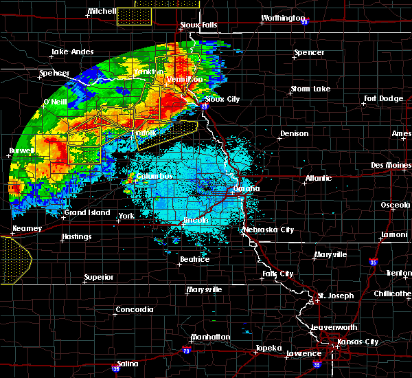 At 1056 pm cdt, severe thunderstorms were located along a line extending from 4 miles southeast of concord to near hadar, moving east at 45 mph (radar indicated). Hazards include 60 mph wind gusts and nickel size hail. Expect damage to roofs. Siding and trees. At 1056 pm cdt, severe thunderstorms were located along a line extending from 4 miles southeast of concord to near hadar, moving east at 45 mph (radar indicated). Hazards include 60 mph wind gusts and nickel size hail. Expect damage to roofs. Siding and trees.
|
| 6/20/2016 4:05 PM CDT |
 At 405 pm cdt, a severe thunderstorm was located 6 miles south of pilger, or 20 miles east of norfolk, moving southeast at 30 mph (radar indicated). Hazards include 60 mph wind gusts and quarter size hail. Hail damage to vehicles is expected. Expect wind damage to roofs, siding and trees. At 405 pm cdt, a severe thunderstorm was located 6 miles south of pilger, or 20 miles east of norfolk, moving southeast at 30 mph (radar indicated). Hazards include 60 mph wind gusts and quarter size hail. Hail damage to vehicles is expected. Expect wind damage to roofs, siding and trees.
|
| 6/18/2016 12:01 AM CDT |
 At 1201 am cdt, severe thunderstorms were located along a line extending from 9 miles west of petersburg to 3 miles south of nickerson, moving south at 15 mph (radar indicated). Hazards include 60 mph wind gusts. Expect damage to roofs. Siding and trees. At 1201 am cdt, severe thunderstorms were located along a line extending from 9 miles west of petersburg to 3 miles south of nickerson, moving south at 15 mph (radar indicated). Hazards include 60 mph wind gusts. Expect damage to roofs. Siding and trees.
|
| 6/17/2016 11:28 PM CDT |
 At 1128 pm cdt, severe thunderstorms were located along a line extending from 5 miles east of hoskins to 4 miles northeast of macy, moving southeast at 25 mph (radar indicated). Hazards include 60 mph wind gusts. Expect damage to roofs. Siding and trees. At 1128 pm cdt, severe thunderstorms were located along a line extending from 5 miles east of hoskins to 4 miles northeast of macy, moving southeast at 25 mph (radar indicated). Hazards include 60 mph wind gusts. Expect damage to roofs. Siding and trees.
|
| 6/17/2016 10:45 PM CDT |
 At 1045 pm cdt, a severe thunderstorm was located near pender, or 31 miles south of ponca, moving south at 20 mph (radar indicated). Hazards include 60 mph wind gusts. Expect damage to roofs. Siding and trees. At 1045 pm cdt, a severe thunderstorm was located near pender, or 31 miles south of ponca, moving south at 20 mph (radar indicated). Hazards include 60 mph wind gusts. Expect damage to roofs. Siding and trees.
|
| 9/22/2015 11:02 AM CDT |
 At 1101 am cdt, a severe thunderstorm was located near pilger, or 15 miles east of norfolk, moving southeast at 15 mph (radar indicated). Hazards include golf ball size hail. People and animals outdoors will be injured. expect damage to roofs, siding, windows and vehicles. locations impacted include, pilger. This includes highway 275 in nebraska between mile markers 87 and 97. At 1101 am cdt, a severe thunderstorm was located near pilger, or 15 miles east of norfolk, moving southeast at 15 mph (radar indicated). Hazards include golf ball size hail. People and animals outdoors will be injured. expect damage to roofs, siding, windows and vehicles. locations impacted include, pilger. This includes highway 275 in nebraska between mile markers 87 and 97.
|
| 9/22/2015 10:45 AM CDT |
 At 1045 am cdt, a severe thunderstorm was located 5 miles north of stanton, or 10 miles east of norfolk, moving southeast at 15 mph (radar indicated). Hazards include golf ball size hail. People and animals outdoors will be injured. Expect damage to roofs, siding, windows and vehicles. At 1045 am cdt, a severe thunderstorm was located 5 miles north of stanton, or 10 miles east of norfolk, moving southeast at 15 mph (radar indicated). Hazards include golf ball size hail. People and animals outdoors will be injured. Expect damage to roofs, siding, windows and vehicles.
|
| 9/22/2015 10:33 AM CDT |
 At 1033 am cdt, a severe thunderstorm was located 6 miles southeast of hoskins, or 9 miles east of norfolk, moving southeast at 25 mph (radar indicated). Hazards include quarter size hail. Damage to vehicles is expected. locations impacted include, pilger. This includes highway 275 in nebraska between mile markers 81 and 93. At 1033 am cdt, a severe thunderstorm was located 6 miles southeast of hoskins, or 9 miles east of norfolk, moving southeast at 25 mph (radar indicated). Hazards include quarter size hail. Damage to vehicles is expected. locations impacted include, pilger. This includes highway 275 in nebraska between mile markers 81 and 93.
|
| 9/22/2015 10:14 AM CDT |
 At 1014 am cdt, a severe thunderstorm was located 5 miles southeast of hoskins, or 10 miles east of norfolk, moving east at 20 mph (radar indicated). Hazards include quarter size hail. damage to vehicles is expected At 1014 am cdt, a severe thunderstorm was located 5 miles southeast of hoskins, or 10 miles east of norfolk, moving east at 20 mph (radar indicated). Hazards include quarter size hail. damage to vehicles is expected
|
| 7/31/2015 5:04 PM CDT | Hen Egg sized hail reported 10.1 miles N of Pilger, NE, also 40 mph winds. siding destroyed on home. windows knocked out. |
| 6/10/2015 8:44 PM CDT |
 At 844 pm cdt, severe thunderstorms were located along a line extending from 6 miles northwest of pilger to near schuyler, moving northeast at 60 mph (radar indicated). Hazards include 60 mph wind gusts and penny size hail. Expect damage to roofs. siding and trees. locations impacted include, columbus, stanton, clarkson, leigh, pilger, richland, the highway 15 and 32 junction, maple creek recreation area, 8 miles south of stanton, 9 miles north of schuyler, camp luther and shell creek elementary school. this includes the following highways, highway 275 in nebraska between mile markers 87 and 96. Highway 30 in nebraska between mile markers 378 and 396. At 844 pm cdt, severe thunderstorms were located along a line extending from 6 miles northwest of pilger to near schuyler, moving northeast at 60 mph (radar indicated). Hazards include 60 mph wind gusts and penny size hail. Expect damage to roofs. siding and trees. locations impacted include, columbus, stanton, clarkson, leigh, pilger, richland, the highway 15 and 32 junction, maple creek recreation area, 8 miles south of stanton, 9 miles north of schuyler, camp luther and shell creek elementary school. this includes the following highways, highway 275 in nebraska between mile markers 87 and 96. Highway 30 in nebraska between mile markers 378 and 396.
|
| 6/10/2015 8:37 PM CDT |
 At 837 pm cdt, severe thunderstorms were located along a line extending from near stanton to 6 miles east of columbus, moving northeast at 60 mph (radar indicated). Hazards include 70 mph wind gusts and penny size hail. Expect considerable tree damage. damage is likely to mobile homes, roofs and outbuildings. locations impacted include, columbus, stanton, clarkson, leigh, pilger, richland, the highway 15 and 32 junction, maple creek recreation area, 8 miles south of stanton, 9 miles north of schuyler, camp luther and shell creek elementary school. this includes the following highways, highway 275 in nebraska between mile markers 87 and 96. Highway 30 in nebraska between mile markers 378 and 396. At 837 pm cdt, severe thunderstorms were located along a line extending from near stanton to 6 miles east of columbus, moving northeast at 60 mph (radar indicated). Hazards include 70 mph wind gusts and penny size hail. Expect considerable tree damage. damage is likely to mobile homes, roofs and outbuildings. locations impacted include, columbus, stanton, clarkson, leigh, pilger, richland, the highway 15 and 32 junction, maple creek recreation area, 8 miles south of stanton, 9 miles north of schuyler, camp luther and shell creek elementary school. this includes the following highways, highway 275 in nebraska between mile markers 87 and 96. Highway 30 in nebraska between mile markers 378 and 396.
|
| 6/10/2015 8:29 PM CDT |
 At 828 pm cdt, severe thunderstorms were located along a line extending from near stanton to near columbus, moving northeast at 80 mph (radar indicated). Hazards include 60 mph wind gusts and penny size hail. Expect damage to roofs. Siding and trees. At 828 pm cdt, severe thunderstorms were located along a line extending from near stanton to near columbus, moving northeast at 80 mph (radar indicated). Hazards include 60 mph wind gusts and penny size hail. Expect damage to roofs. Siding and trees.
|
| 6/6/2015 10:53 PM CDT | Storm damage reported in stanton county NE, 1.8 miles N of Pilger, NE |
| 6/3/2014 3:07 PM CDT | Golf Ball sized hail reported 0.4 miles SW of Pilger, NE |
| 1/1/0001 12:00 AM | Storm damage reported in cuming county NE, 2.6 miles WNW of Pilger, NE |
Hail Maps for Pilger, NE
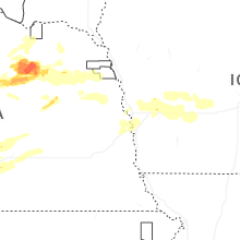
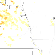


Connect with Interactive Hail Maps