

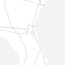
Hail Map for Monday, June 10, 2019

Number of Impacted Households on 6/10/2019
0
Impacted by 1" or Larger Hail
0
Impacted by 1.75" or Larger Hail
0
Impacted by 2.5" or Larger Hail
Square Miles of Populated Area Impacted on 6/10/2019
0
Impacted by 1" or Larger Hail
0
Impacted by 1.75" or Larger Hail
0
Impacted by 2.5" or Larger Hail

Cities Most Affected by Hail Storms of 6/10/2019
| Hail Size | Demographics of Zip Codes Affected | ||||||
|---|---|---|---|---|---|---|---|
| City | Count | Average | Largest | Pop Density | House Value | Income | Age |
Hail and Wind Damage Spotted on 6/10/2019
Filter by Report Type:Hail ReportsWind Reports
Georgia
| Local Time | Report Details |
|---|---|
| 4:14 PM EDT | A few trees were downed near the intersection of old jefferson highway and state road 110. time estimated by rada in camden county GA, 41.7 miles N of Jacksonville, FL |
Virginia
| Local Time | Report Details |
|---|---|
| 5:15 PM EDT | Tree down - penn forest roa in roanoke county VA, 4.8 miles SW of Roanoke, VA |
Texas
| Local Time | Report Details |
|---|---|
| 4:30 PM CDT | Willacy county emergency manager reports damage to 8 utility poles and 20 to 30 mesquite trees on the frontage road near the intersection of conley and 77. damage to ut in willacy county TX, 43.7 miles NNW of Brownsville, TX |
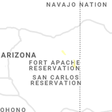
Arizona
| Local Time | Report Details |
|---|---|
| 4:05 PM MST | Quarter sized hail reported near Nutrioso, AZ, 50.8 miles ESE of Show Low, AZ, trained spotter reported hail falling that was the size of a quarter with larger hail stones intermixed. |
Wisconsin
| Local Time | Report Details |
|---|---|
| 6:21 PM CDT | Three to four trees down. one across a county highway in marathon county WI, 48 miles SSW of Rhinelander, WI |
Connect with Interactive Hail Maps