

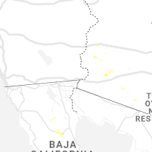
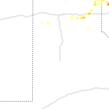
Hail Map for Saturday, June 25, 2022

Number of Impacted Households on 6/25/2022
0
Impacted by 1" or Larger Hail
0
Impacted by 1.75" or Larger Hail
0
Impacted by 2.5" or Larger Hail
Square Miles of Populated Area Impacted on 6/25/2022
0
Impacted by 1" or Larger Hail
0
Impacted by 1.75" or Larger Hail
0
Impacted by 2.5" or Larger Hail


Cities Most Affected by Hail Storms of 6/25/2022
| Hail Size | Demographics of Zip Codes Affected | ||||||
|---|---|---|---|---|---|---|---|
| City | Count | Average | Largest | Pop Density | House Value | Income | Age |
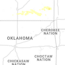
| David City, NE | 3 | 2.08 | 2.75 | 25 | $67k | $36.1k | 42.0 |
| Saint Charles, IA | 1 | 1.75 | 1.75 | 27 | $103k | $51.4k | 41.3 |
| Cheyenne, OK | 1 | 1.75 | 1.75 | 3 | $52k | $28.7k | 39.7 |
| Winterset, IA | 1 | 1.75 | 1.75 | 41 | $87k | $37.1k | 40.1 |
Hail and Wind Damage Spotted on 6/25/2022
Filter by Report Type:Hail ReportsWind Reports
States Impacted
Iowa, Illinois, Nebraska, Minnesota, Florida, Alabama, West Virginia, Tennessee, Kentucky, Louisiana, Oklahoma, Texas, Arizona, Kansas, MissouriIowa
| Local Time | Report Details |
|---|---|
| 7:06 AM CDT | Golf Ball sized hail reported near Winterset, IA, 25.9 miles SW of Des Moines, IA, social media report. |
| 7:07 AM CDT | Ping Pong Ball sized hail reported near Winterset, IA, 25.1 miles SW of Des Moines, IA, report from social media. |
| 7:18 AM CDT | Golf Ball sized hail reported near Saint Charles, IA, 17.3 miles SSW of Des Moines, IA, time estimated from radar. report from social media. |
| 7:29 AM CDT | Ping Pong Ball sized hail reported near Indianola, IA, 17.3 miles S of Des Moines, IA, report from social media one half mile south of hwy 92 roughly 4 miles west of indianola. half dollar to ping pong ball sized hail. time estimated from radar. |
| 7:34 AM CDT | Quarter sized hail reported near Indianola, IA, 15.5 miles SSE of Des Moines, IA, nickel to quarter sized hail on northeast side of indianola. report from social media. time estimated from radar. |
Illinois
| Local Time | Report Details |
|---|---|
| 7:17 AM CDT | Public report and a picture of a large tree down taking powerlines with it. time estimated by rada in rock island county IL, 66.6 miles ESE of Cedar Rapids, IA |
| 9:00 PM CDT | Power lines down. time estimated. relayed by medi in peoria county IL, 1.9 miles N of Peoria, IL |
| 9:25 PM CDT | Estimated 70 mph gus in woodford county IL, 15.8 miles E of Peoria, IL |
Nebraska
| Local Time | Report Details |
|---|---|
| 8:32 AM CDT | Baseball sized hail reported near David City, NE, 61.9 miles W of Omaha, NE, measurement from a picture on social medial. |
| 8:35 AM CDT | Ping Pong Ball sized hail reported near David City, NE, 61.9 miles W of Omaha, NE, public report on the north side of david city. |
| 8:36 AM CDT | Golf Ball sized hail reported near David City, NE, 61.9 miles W of Omaha, NE, size estimated from a picture submitted via social media. |
| 9:13 AM CDT | Golf Ball sized hail reported near David City, NE, 62.7 miles ENE of Grand Island, NE, time estimated based on radar... report from social media. |
Minnesota
| Local Time | Report Details |
|---|---|
| 10:57 AM CDT | Area of tree damage with multiple trees snapped off... downing power lines and blocking the road. report from social media. time estimated off rada in cass county MN, 32 miles SSE of Bemidji, MN |
Florida
| Local Time | Report Details |
|---|---|
| 2:53 PM EDT | Asos station khwo pembroke pine in broward county FL, 18.7 miles N of Miami, FL |
Alabama
| Local Time | Report Details |
|---|---|
| 2:45 PM CDT | Emergency manager reports multiple trees down near the highway 43 and al highway 5 intersection near thomasvill in clarke county AL, 26.7 miles W of Camden, AL |
| 2:53 PM CDT | Estimated 50-60 mph winds with damage to a fence near daphn in baldwin county AL, 13.7 miles ESE of Mobile, AL |
| 4:20 PM CDT | Several large branches were blown down... winds estimated at 55 mph... and half inch hai in hale county AL, 44.1 miles NNW of Camden, AL |
West Virginia
| Local Time | Report Details |
|---|---|
| 4:03 PM EDT | Tree down in bentre in clay county WV, 21.7 miles E of Charleston, WV |
| 4:03 PM EDT | Corrects location for previous tstm wind damege report of tree down in bentre in clay county WV, 24.9 miles E of Charleston, WV |
| 6:41 PM EDT | Numerous trees blew down along river r in hardy county WV, 44.2 miles E of Elkins, WV |
| 6:43 PM EDT | Several trees blew down along rig r in hardy county WV, 45.2 miles ENE of Elkins, WV |
| 6:43 PM EDT | A large tree blew down blocking darlington school r in hardy county WV, 45 miles ENE of Elkins, WV |
Tennessee
| Local Time | Report Details |
|---|---|
| 4:15 PM EDT | A few trees down in white pine along main street and roy messer highway. report from retired national weather service employe in jefferson county TN, 36.6 miles ENE of Knoxville, TN |
| 8:05 PM CDT | Several trees down in livingston including on buena vista driv in overton county TN, 83.3 miles WNW of Knoxville, TN |
Kentucky
| Local Time | Report Details |
|---|---|
| 4:50 PM EDT | Tree dow in lawrence county KY, 64.9 miles WSW of Charleston, WV |
Louisiana
| Local Time | Report Details |
|---|---|
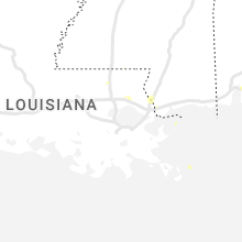
| 5:21 PM CDT | Delayed report - nws employee reports tree down on robert rd across from st. joe apartments. time estimated based on rada in st. tammany county LA, 33.1 miles NE of New Orleans, LA |
Oklahoma
| Local Time | Report Details |
|---|---|
| 5:25 PM CDT | Quarter sized hail reported near Cheyenne, OK, 59.4 miles SSW of Woodward, OK, em relayed in nwschat with picture in the report. |
| 5:40 PM CDT | Golf Ball sized hail reported near Cheyenne, OK, 59.5 miles SSW of Woodward, OK, twitter video forwarded by broadcast media... time is radar estimated. |
| 6:03 PM CDT | Quarter sized hail reported near Cheyenne, OK, 60.8 miles SSW of Woodward, OK, em relayed in nwschat |
Texas
| Local Time | Report Details |
|---|---|
| 6:45 PM CDT | Tree limbs down around town... of which were at least 3 inches in diamete in donley county TX, 54.6 miles E of Amarillo, TX |
| 6:46 PM CDT | Quarter sized hail reported near Clarendon, TX, 54.6 miles E of Amarillo, TX |
Arizona
| Local Time | Report Details |
|---|---|
| 4:45 PM MST | Hurricane raws site in arizona gusted to 63mph from a nearby thunderstorm. time estimated as hurricane raws only report observations once per hou in mohave county AZ, 35 miles SE of Saint George, UT |
| 8:01 PM MST | Mesonet weather station reported 59 mph wind gus in la paz county AZ, 50.7 miles NNE of Yuma, AZ |
Kansas
| Local Time | Report Details |
|---|---|
| 8:54 PM CDT | Quarter sized hail reported near Parsons, KS, 25.2 miles SSE of Chanute, KS |
| 12:30 AM CDT | Quarter sized hail reported near Wellington, KS, 20.9 miles SSW of Wichita, KS |
| 2:30 AM CDT | Various sizes of limbs down in arcadia... largest being about 6 inches in diameter so fa in crawford county KS, 45.7 miles E of Chanute, KS |
Missouri
| Local Time | Report Details |
|---|---|
| 5:20 AM CDT | Main power line down at the old rock quarry ra and 64 hwy jct. time estimated via rada in hickory county MO, 42.1 miles N of Springfield, MO |
| 5:25 AM CDT | Off 365 loop southeastern hickory county 3 to 4 inch diameter trees down lots of limbs down approximately 1 inch of rain. time estimated via rada in hickory county MO, 42.2 miles N of Springfield, MO |
Connect with Interactive Hail Maps