

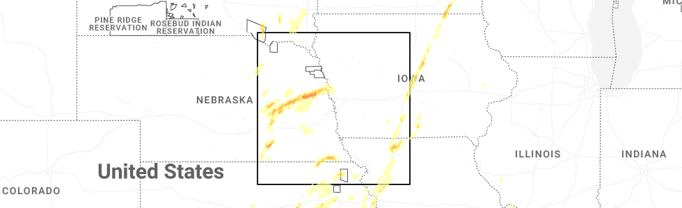
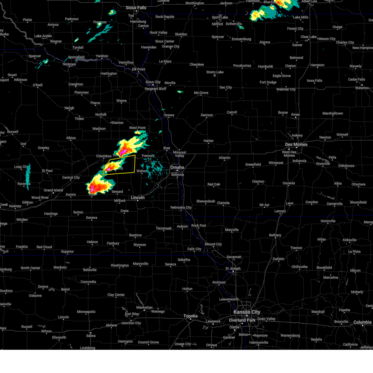
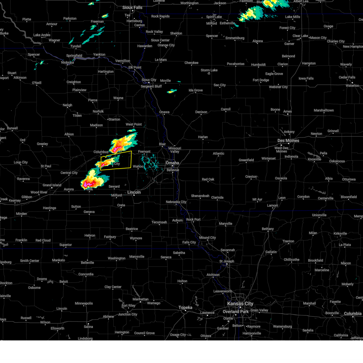
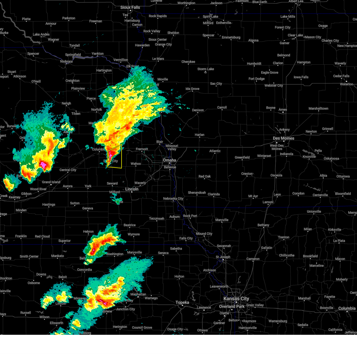
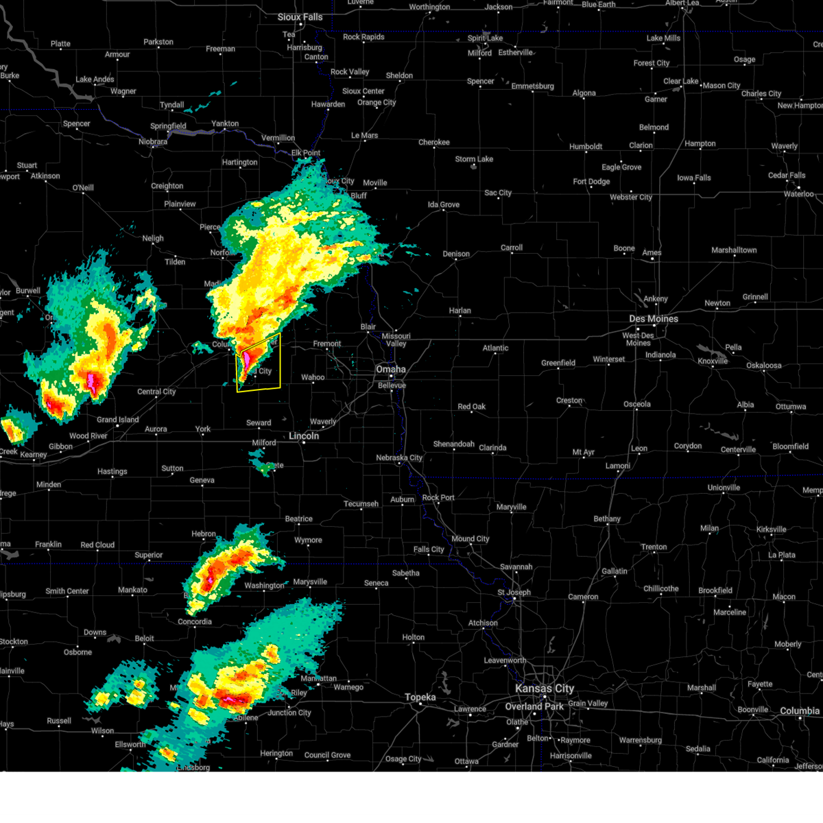
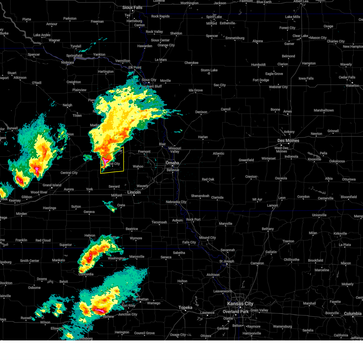
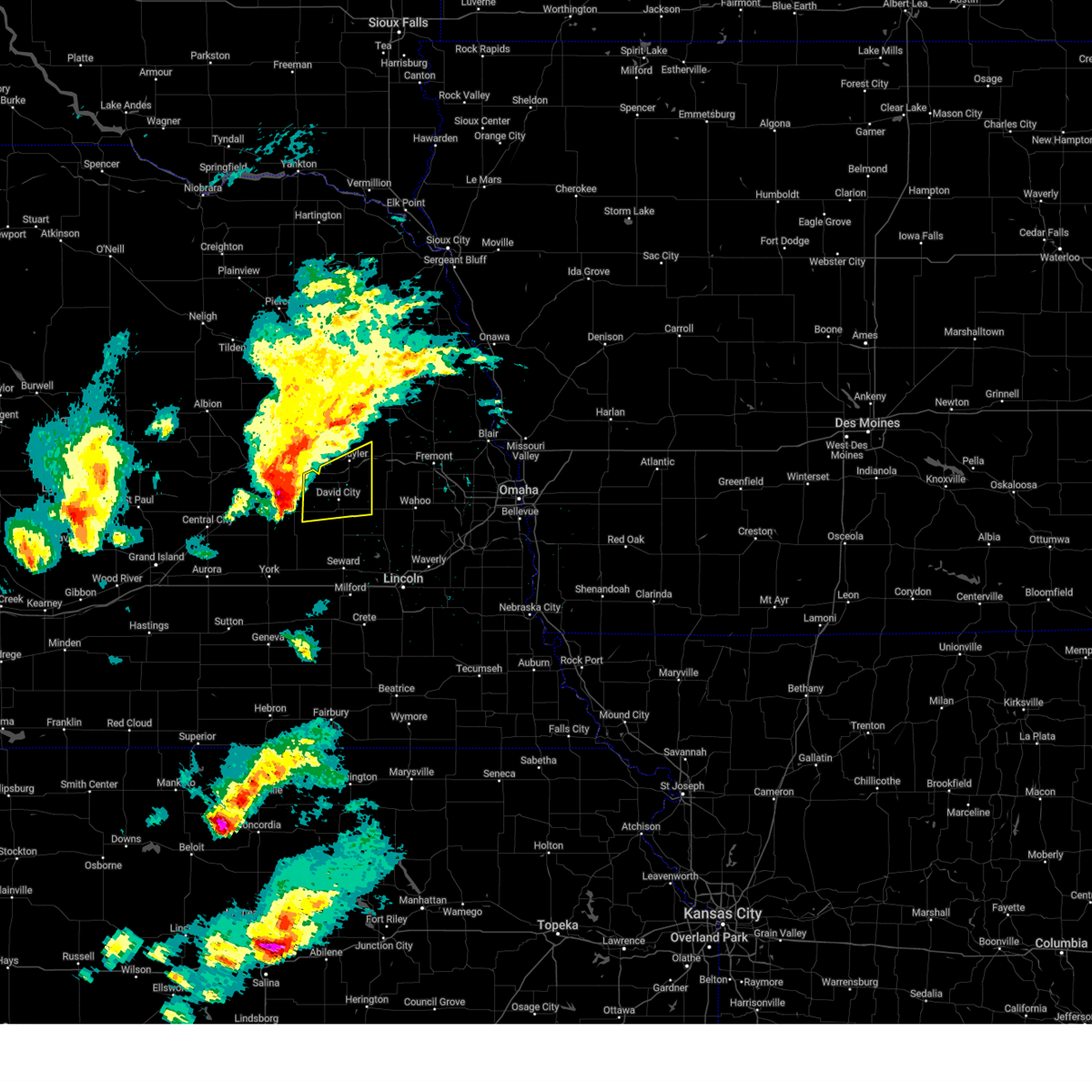
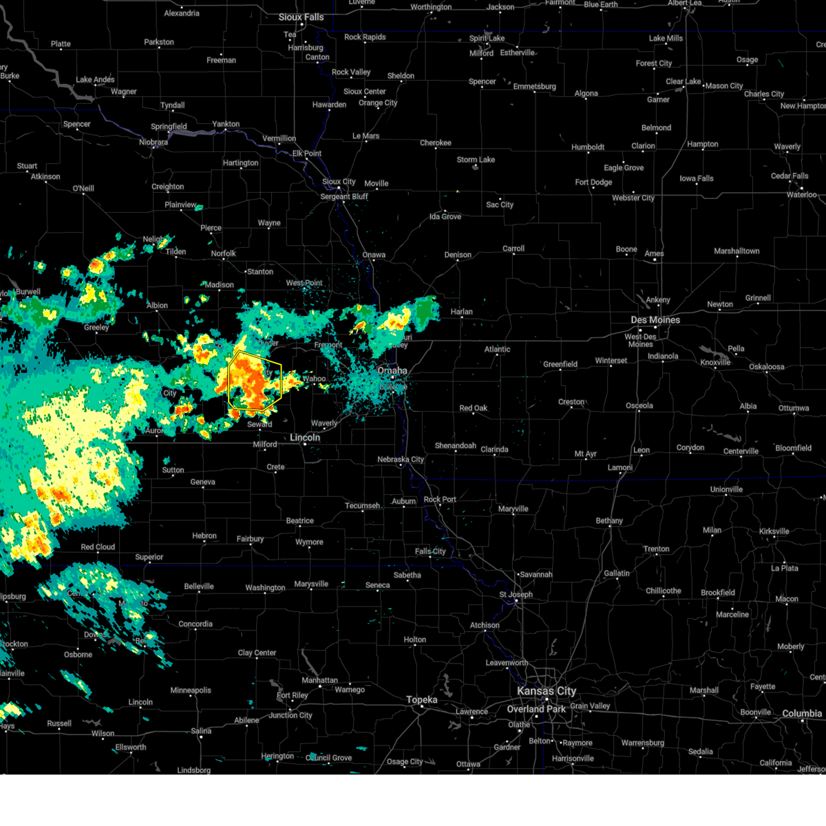
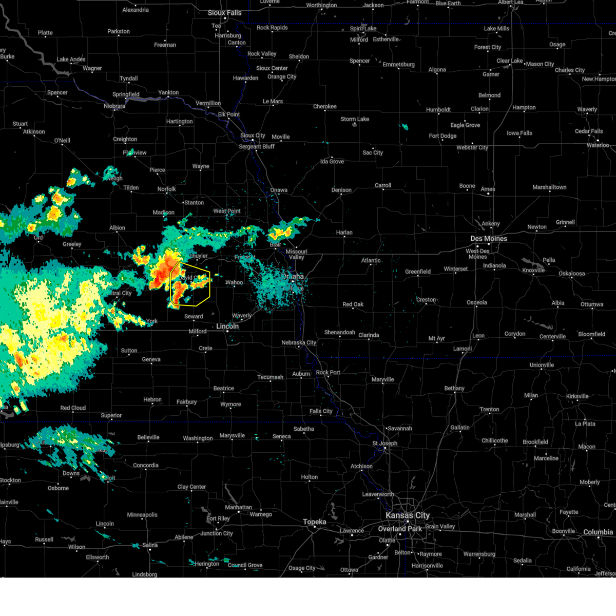
Hail Map for David City, NE
The David City, NE area has had 24 reports of on-the-ground hail by trained spotters, and has been under severe weather warnings 17 times during the past 12 months. Doppler radar has detected hail at or near David City, NE on 104 occasions, including 4 occasions during the past year.
| Name: | David City, NE |
| Where Located: | 61.8 miles W of Omaha, NE |
| Map: | Google Map for David City, NE |
| Population: | 2906 |
| Housing Units: | 1274 |
| More Info: | Search Google for David City, NE |
1
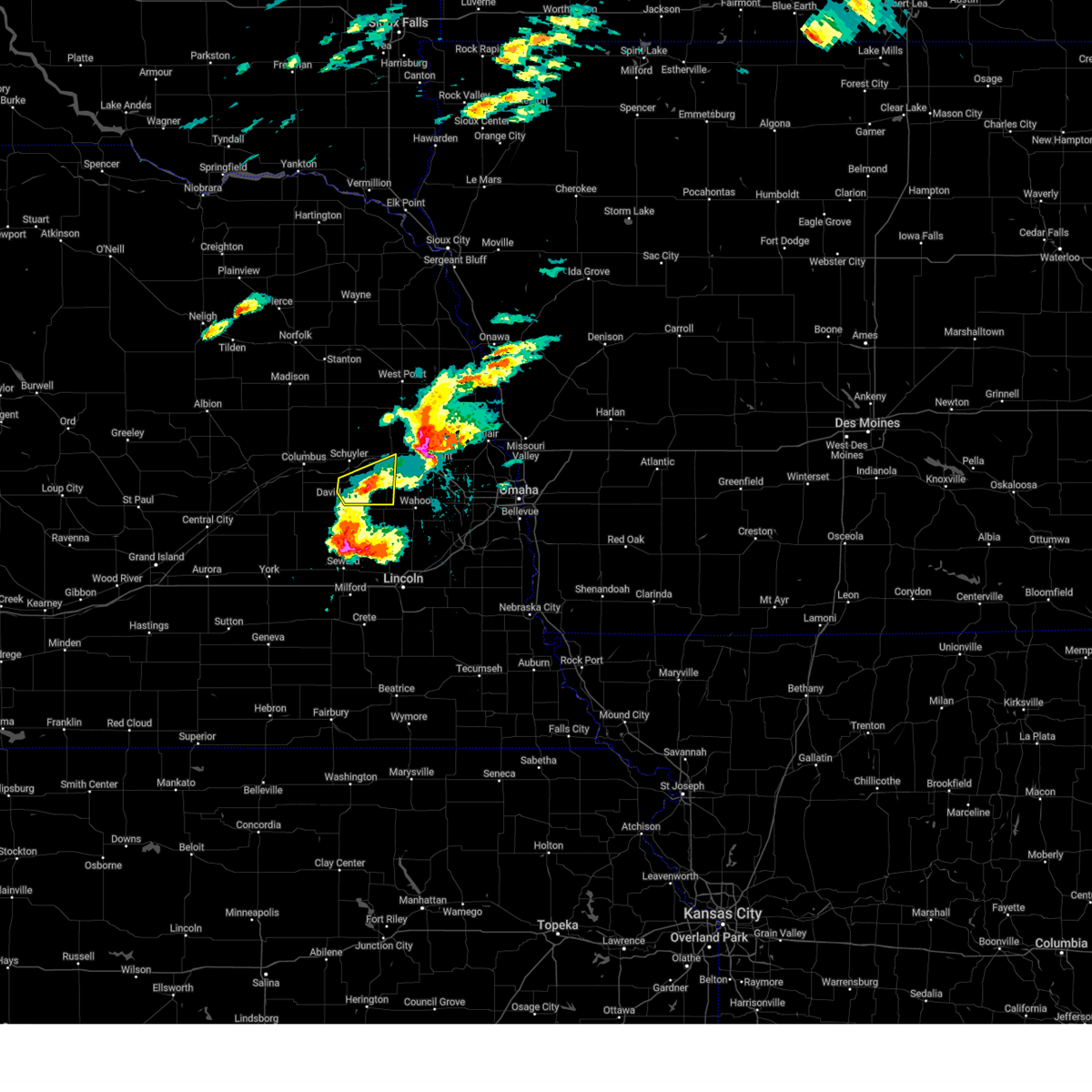
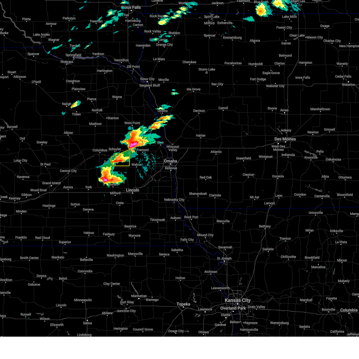
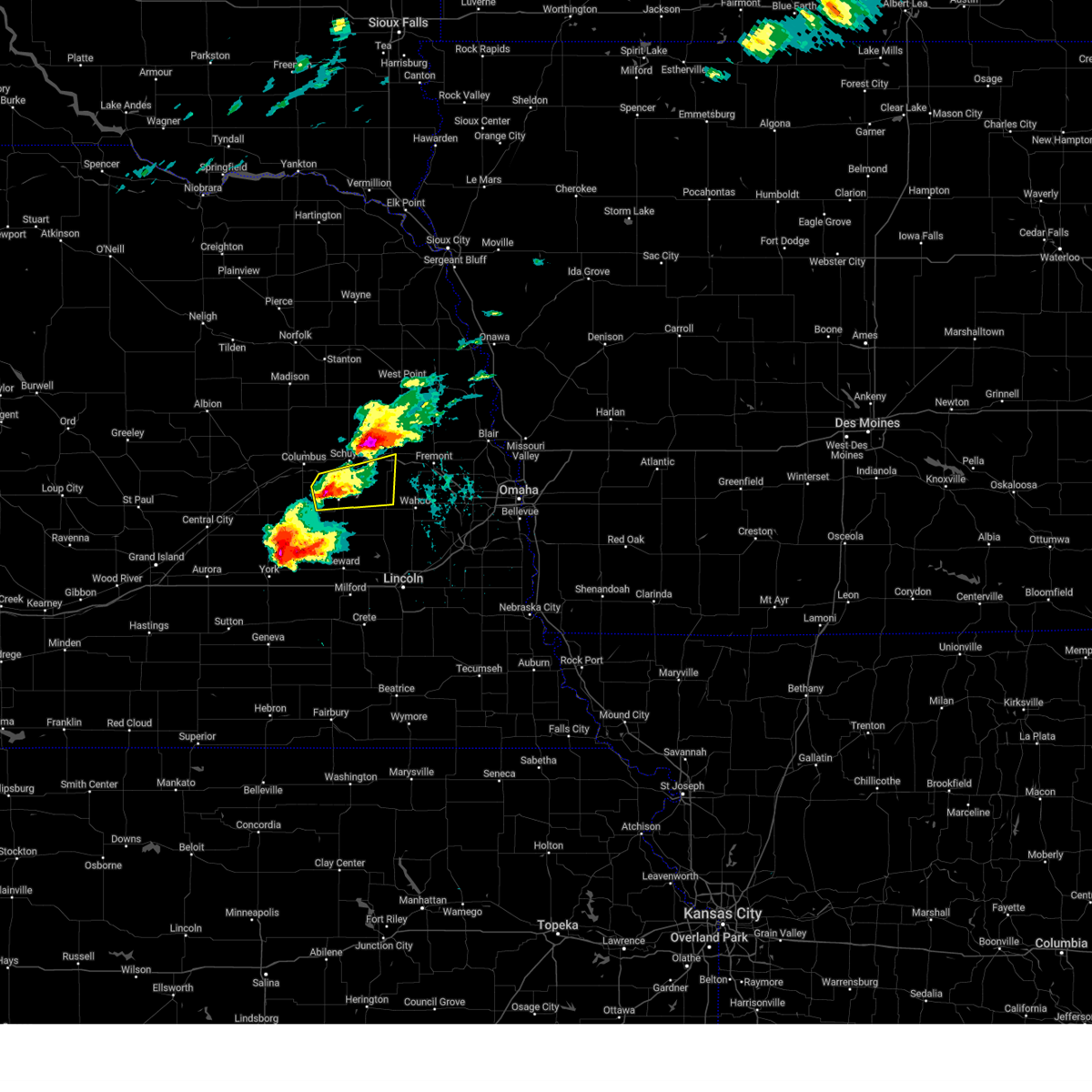
The Top Recent Hail Date for David City, NE is Monday, May 19, 2025 (17th out of 104)
Hail and Wind Damage Spotted near David City, NE
| Date / Time | Report Details |
|---|---|
| 5/19/2025 5:37 PM CDT | Svroax the national weather service in omaha has issued a * severe thunderstorm warning for, southeastern colfax county in northeastern nebraska, southwestern dodge county in east central nebraska, eastern butler county in east central nebraska, northwestern saunders county in east central nebraska, * until 630 pm cdt. * at 537 pm cdt, a severe thunderstorm was located near octavia, or 5 miles northeast of david city, moving northeast at 25 mph (radar indicated). Hazards include 60 mph wind gusts and half dollar size hail. Hail damage to vehicles is expected. expect wind damage to roofs, siding, and trees. this severe thunderstorm will be near, octavia and abie around 545 pm cdt. linwood around 550 pm cdt. Other locations in the path of this severe thunderstorm include north bend and morse bluff. |
| 5/19/2025 5:14 PM CDT | At 512 pm cdt, a severe thunderstorm was located 5 miles north of schuyler, or 17 miles east of columbus, moving northeast at 30 mph (trained weather spotters. at 510 pm, ping pong ball size hail was reported 3 miles northwest of schuyler). Hazards include ping pong ball size hail and 60 mph wind gusts. People and animals outdoors will be injured. expect hail damage to roofs, siding, windows, and vehicles. expect wind damage to roofs, siding, and trees. This severe thunderstorm will remain over mainly rural areas of colfax, southeastern platte, southwestern dodge, northern butler and northwestern saunders counties, including the following locations, fishers elementary, central community college, rogers, lake babcock, camp pawnee, camp luther, and lake north. |
| 5/19/2025 4:50 PM CDT | Svroax the national weather service in omaha has issued a * severe thunderstorm warning for, colfax county in northeastern nebraska, southeastern platte county in northeastern nebraska, southwestern dodge county in east central nebraska, northern butler county in east central nebraska, northwestern saunders county in east central nebraska, * until 530 pm cdt. * at 450 pm cdt, a severe thunderstorm was located over richland, or 8 miles east of columbus, moving northeast at 30 mph (radar indicated). Hazards include ping pong ball size hail and 60 mph wind gusts. People and animals outdoors will be injured. expect hail damage to roofs, siding, windows, and vehicles. expect wind damage to roofs, siding, and trees. This severe thunderstorm will be near, schuyler around 455 pm cdt. |
| 5/19/2025 4:29 PM CDT | At 426 pm cdt, a severe thunderstorm was located 3 miles south of columbus, moving northeast at 30 mph (trained weather spotters. at 425 pm, golf ball sized hail was reported 7 miles west-southwest of bellwood, and in columbus). Hazards include golf ball size hail and 60 mph wind gusts. People and animals outdoors will be injured. expect hail damage to roofs, siding, windows, and vehicles. expect wind damage to roofs, siding, and trees. this severe storm will be near, columbus around 430 pm cdt. Other locations in the path of this severe thunderstorm include richland. |
| 5/19/2025 4:14 PM CDT | Svroax the national weather service in omaha has issued a * severe thunderstorm warning for, southwestern colfax county in northeastern nebraska, southeastern platte county in northeastern nebraska, northern butler county in east central nebraska, * until 500 pm cdt. * at 414 pm cdt, a severe thunderstorm was located 5 miles south of duncan, or 11 miles southwest of columbus, moving northeast at 30 mph (radar indicated). Hazards include ping pong ball size hail and 60 mph wind gusts. People and animals outdoors will be injured. expect hail damage to roofs, siding, windows, and vehicles. expect wind damage to roofs, siding, and trees. this severe thunderstorm will be near, columbus around 430 pm cdt. Other locations in the path of this severe thunderstorm include bellwood and richland. |
| 4/17/2025 6:24 PM CDT |
 The storm which prompted the warning has weakened below severe limits, and no longer poses an immediate threat to life or property. therefore, the warning will be allowed to expire. however, small hail is still possible with this thunderstorm. a tornado watch remains in effect until midnight cdt for east central nebraska. The storm which prompted the warning has weakened below severe limits, and no longer poses an immediate threat to life or property. therefore, the warning will be allowed to expire. however, small hail is still possible with this thunderstorm. a tornado watch remains in effect until midnight cdt for east central nebraska.
|
| 4/17/2025 6:15 PM CDT |
 At 615 pm cdt, a severe thunderstorm was located 3 miles southeast of octavia, or 6 miles northeast of david city, moving east at 35 mph (radar indicated). Hazards include 60 mph wind gusts and quarter size hail. Hail damage to vehicles is expected. expect wind damage to roofs, siding, and trees. Locations impacted include, bruno, abie, prague and morse bluff. At 615 pm cdt, a severe thunderstorm was located 3 miles southeast of octavia, or 6 miles northeast of david city, moving east at 35 mph (radar indicated). Hazards include 60 mph wind gusts and quarter size hail. Hail damage to vehicles is expected. expect wind damage to roofs, siding, and trees. Locations impacted include, bruno, abie, prague and morse bluff.
|
| 4/17/2025 6:15 PM CDT |
 the severe thunderstorm warning has been cancelled and is no longer in effect the severe thunderstorm warning has been cancelled and is no longer in effect
|
| 4/17/2025 5:59 PM CDT |
 At 558 pm cdt, a severe thunderstorm was located 3 miles northwest of david city, moving northeast at 40 mph (radar indicated). Hazards include 60 mph wind gusts and half dollar size hail. Hail damage to vehicles is expected. expect wind damage to roofs, siding, and trees. this severe storm will be near, octavia around 605 pm cdt. abie around 610 pm cdt. Other locations in the path of this severe thunderstorm include linwood, north bend and morse bluff. At 558 pm cdt, a severe thunderstorm was located 3 miles northwest of david city, moving northeast at 40 mph (radar indicated). Hazards include 60 mph wind gusts and half dollar size hail. Hail damage to vehicles is expected. expect wind damage to roofs, siding, and trees. this severe storm will be near, octavia around 605 pm cdt. abie around 610 pm cdt. Other locations in the path of this severe thunderstorm include linwood, north bend and morse bluff.
|
| 4/17/2025 5:56 PM CDT | Tennis Ball sized hail reported 2.1 miles SW of David City, NE, time estimated from radar. actual measurement was 2.4. |
| 4/17/2025 5:50 PM CDT |
 At 550 pm cdt, a severe thunderstorm was located 4 miles south of bellwood, or 6 miles west of david city, moving northeast at 40 mph (radar indicated). Hazards include 60 mph wind gusts and half dollar size hail. Hail damage to vehicles is expected. expect wind damage to roofs, siding, and trees. this severe storm will be near, david city and bellwood around 555 pm cdt. octavia around 600 pm cdt. Other locations in the path of this severe thunderstorm include abie, linwood, north bend and morse bluff. At 550 pm cdt, a severe thunderstorm was located 4 miles south of bellwood, or 6 miles west of david city, moving northeast at 40 mph (radar indicated). Hazards include 60 mph wind gusts and half dollar size hail. Hail damage to vehicles is expected. expect wind damage to roofs, siding, and trees. this severe storm will be near, david city and bellwood around 555 pm cdt. octavia around 600 pm cdt. Other locations in the path of this severe thunderstorm include abie, linwood, north bend and morse bluff.
|
| 4/17/2025 5:40 PM CDT |
 Svroax the national weather service in omaha has issued a * severe thunderstorm warning for, southern colfax county in northeastern nebraska, southwestern dodge county in east central nebraska, central butler county in east central nebraska, northwestern saunders county in east central nebraska, * until 630 pm cdt. * at 539 pm cdt, a severe thunderstorm was located 5 miles north of rising city, or 10 miles west of david city, moving northeast at 35 mph (radar indicated). Hazards include 60 mph wind gusts and quarter size hail. Hail damage to vehicles is expected. expect wind damage to roofs, siding, and trees. this severe thunderstorm will be near, bellwood around 545 pm cdt. octavia around 555 pm cdt. Other locations in the path of this severe thunderstorm include linwood, abie, north bend and morse bluff. Svroax the national weather service in omaha has issued a * severe thunderstorm warning for, southern colfax county in northeastern nebraska, southwestern dodge county in east central nebraska, central butler county in east central nebraska, northwestern saunders county in east central nebraska, * until 630 pm cdt. * at 539 pm cdt, a severe thunderstorm was located 5 miles north of rising city, or 10 miles west of david city, moving northeast at 35 mph (radar indicated). Hazards include 60 mph wind gusts and quarter size hail. Hail damage to vehicles is expected. expect wind damage to roofs, siding, and trees. this severe thunderstorm will be near, bellwood around 545 pm cdt. octavia around 555 pm cdt. Other locations in the path of this severe thunderstorm include linwood, abie, north bend and morse bluff.
|
| 4/1/2025 9:25 PM CDT | Personal weather statio in butler county NE, 2.1 miles SW of David City, NE |
| 4/1/2025 9:25 PM CDT |
 At 925 pm cdt, a severe thunderstorm was located 3 miles northeast of octavia, or 10 miles northeast of david city, moving east at 50 mph (radar indicated). Hazards include 60 mph wind gusts and quarter size hail. Hail damage to vehicles is expected. expect wind damage to roofs, siding, and trees. Locations impacted include, bruno, octavia, abie, linwood, rogers, schuyler, david city, and brainard. At 925 pm cdt, a severe thunderstorm was located 3 miles northeast of octavia, or 10 miles northeast of david city, moving east at 50 mph (radar indicated). Hazards include 60 mph wind gusts and quarter size hail. Hail damage to vehicles is expected. expect wind damage to roofs, siding, and trees. Locations impacted include, bruno, octavia, abie, linwood, rogers, schuyler, david city, and brainard.
|
| 4/1/2025 9:17 PM CDT |
 At 916 pm cdt, a severe thunderstorm was located 3 miles east of bellwood, or 6 miles north of david city, moving east at 45 mph (radar indicated). Hazards include 60 mph wind gusts and quarter size hail. Hail damage to vehicles is expected. expect wind damage to roofs, siding, and trees. Locations impacted include, bruno, octavia, abie, linwood, garrison, rogers, schuyler, david city, bellwood, brainard, and rising city. At 916 pm cdt, a severe thunderstorm was located 3 miles east of bellwood, or 6 miles north of david city, moving east at 45 mph (radar indicated). Hazards include 60 mph wind gusts and quarter size hail. Hail damage to vehicles is expected. expect wind damage to roofs, siding, and trees. Locations impacted include, bruno, octavia, abie, linwood, garrison, rogers, schuyler, david city, bellwood, brainard, and rising city.
|
| 4/1/2025 9:10 PM CDT |
 At 909 pm cdt, a severe thunderstorm was located near bellwood, or 7 miles northwest of david city, moving east at 45 mph (radar indicated). Hazards include 60 mph wind gusts and half dollar size hail. Hail damage to vehicles is expected. expect wind damage to roofs, siding, and trees. Locations impacted include, bruno, octavia, abie, linwood, garrison, rogers, schuyler, david city, rising city, bellwood, and brainard. At 909 pm cdt, a severe thunderstorm was located near bellwood, or 7 miles northwest of david city, moving east at 45 mph (radar indicated). Hazards include 60 mph wind gusts and half dollar size hail. Hail damage to vehicles is expected. expect wind damage to roofs, siding, and trees. Locations impacted include, bruno, octavia, abie, linwood, garrison, rogers, schuyler, david city, rising city, bellwood, and brainard.
|
| 4/1/2025 8:56 PM CDT |
 Svroax the national weather service in omaha has issued a * severe thunderstorm warning for, southern colfax county in northeastern nebraska, butler county in east central nebraska, * until 945 pm cdt. * at 855 pm cdt, a severe thunderstorm was located 4 miles north of shelby, or 12 miles south of columbus, moving east at 40 mph (radar indicated). Hazards include 60 mph wind gusts and quarter size hail. Hail damage to vehicles is expected. Expect wind damage to roofs, siding, and trees. Svroax the national weather service in omaha has issued a * severe thunderstorm warning for, southern colfax county in northeastern nebraska, butler county in east central nebraska, * until 945 pm cdt. * at 855 pm cdt, a severe thunderstorm was located 4 miles north of shelby, or 12 miles south of columbus, moving east at 40 mph (radar indicated). Hazards include 60 mph wind gusts and quarter size hail. Hail damage to vehicles is expected. Expect wind damage to roofs, siding, and trees.
|
| 8/8/2024 12:42 AM CDT |
 the severe thunderstorm warning has been cancelled and is no longer in effect the severe thunderstorm warning has been cancelled and is no longer in effect
|
| 8/8/2024 12:24 AM CDT |
 Svroax the national weather service in omaha has issued a * severe thunderstorm warning for, southwestern colfax county in northeastern nebraska, eastern platte county in northeastern nebraska, butler county in east central nebraska, * until 100 am cdt. * at 1224 am cdt, severe thunderstorms were located along a line extending from 2 miles north of bellwood to 7 miles north of rising city to 2 miles east of osceola, moving southeast at 40 mph (radar indicated). Hazards include 60 mph wind gusts and penny size hail. expect damage to roofs, siding, and trees Svroax the national weather service in omaha has issued a * severe thunderstorm warning for, southwestern colfax county in northeastern nebraska, eastern platte county in northeastern nebraska, butler county in east central nebraska, * until 100 am cdt. * at 1224 am cdt, severe thunderstorms were located along a line extending from 2 miles north of bellwood to 7 miles north of rising city to 2 miles east of osceola, moving southeast at 40 mph (radar indicated). Hazards include 60 mph wind gusts and penny size hail. expect damage to roofs, siding, and trees
|
| 7/1/2024 9:39 PM CDT |
 At 939 pm cdt, severe thunderstorms were located along a line extending from 3 miles northeast of howells to 6 miles north of linwood to 3 miles northwest of brainard, moving northeast at 45 mph (radar indicated). Hazards include 60 mph wind gusts. Expect damage to roofs, siding, and trees. Locations impacted include, david city, brainard, and garrison. At 939 pm cdt, severe thunderstorms were located along a line extending from 3 miles northeast of howells to 6 miles north of linwood to 3 miles northwest of brainard, moving northeast at 45 mph (radar indicated). Hazards include 60 mph wind gusts. Expect damage to roofs, siding, and trees. Locations impacted include, david city, brainard, and garrison.
|
| 7/1/2024 9:39 PM CDT |
 the severe thunderstorm warning has been cancelled and is no longer in effect the severe thunderstorm warning has been cancelled and is no longer in effect
|
| 7/1/2024 9:38 PM CDT |
 Svroax the national weather service in omaha has issued a * severe thunderstorm warning for, northern lancaster county in southeastern nebraska, northeastern seward county in southeastern nebraska, southeastern butler county in east central nebraska, southwestern saunders county in east central nebraska, * until 1030 pm cdt. * at 937 pm cdt, a severe thunderstorm was located 3 miles northwest of dwight, or 9 miles south of david city, moving east at 35 mph (radar indicated). Hazards include 60 mph wind gusts. Expect damage to roofs, siding, and trees. this severe thunderstorm will be near, david city at 935 pm cdt. dwight around 945 pm cdt. valparaiso around 950 pm cdt. ceresco around 1005 pm cdt. Other locations impacted by this severe thunderstorm include lake wanahoo recreation area and garrison. Svroax the national weather service in omaha has issued a * severe thunderstorm warning for, northern lancaster county in southeastern nebraska, northeastern seward county in southeastern nebraska, southeastern butler county in east central nebraska, southwestern saunders county in east central nebraska, * until 1030 pm cdt. * at 937 pm cdt, a severe thunderstorm was located 3 miles northwest of dwight, or 9 miles south of david city, moving east at 35 mph (radar indicated). Hazards include 60 mph wind gusts. Expect damage to roofs, siding, and trees. this severe thunderstorm will be near, david city at 935 pm cdt. dwight around 945 pm cdt. valparaiso around 950 pm cdt. ceresco around 1005 pm cdt. Other locations impacted by this severe thunderstorm include lake wanahoo recreation area and garrison.
|
| 7/1/2024 9:27 PM CDT |
 At 926 pm cdt, severe thunderstorms were located along a line extending from near clarkson to 2 miles west of schuyler to 4 miles north of ulysses, moving east at 50 mph (radar indicated). Hazards include 60 mph wind gusts. Expect damage to roofs, siding, and trees. Locations impacted include, columbus, david city, schuyler, clarkson, howells, bellwood, leigh, rising city, brainard, creston, octavia, richland, lakeview, garrison, fishers elementary, camp pawnee, shell creek elementary school, maple creek recreation area, camp luther, and lake north. At 926 pm cdt, severe thunderstorms were located along a line extending from near clarkson to 2 miles west of schuyler to 4 miles north of ulysses, moving east at 50 mph (radar indicated). Hazards include 60 mph wind gusts. Expect damage to roofs, siding, and trees. Locations impacted include, columbus, david city, schuyler, clarkson, howells, bellwood, leigh, rising city, brainard, creston, octavia, richland, lakeview, garrison, fishers elementary, camp pawnee, shell creek elementary school, maple creek recreation area, camp luther, and lake north.
|
| 7/1/2024 9:15 PM CDT |
 At 915 pm cdt, severe thunderstorms were located along a line extending from 3 miles northwest of leigh to 7 miles northeast of lakeview to 2 miles northwest of rising city, moving northeast at 40 mph (radar indicated). Hazards include 60 mph wind gusts. Expect damage to roofs, siding, and trees. Locations impacted include, columbus, david city, schuyler, humphrey, clarkson, howells, bellwood, leigh, rising city, duncan, platte center, brainard, creston, octavia, richland, lakeview, garrison, tarnov, college view trailer park, and camp pawnee. At 915 pm cdt, severe thunderstorms were located along a line extending from 3 miles northwest of leigh to 7 miles northeast of lakeview to 2 miles northwest of rising city, moving northeast at 40 mph (radar indicated). Hazards include 60 mph wind gusts. Expect damage to roofs, siding, and trees. Locations impacted include, columbus, david city, schuyler, humphrey, clarkson, howells, bellwood, leigh, rising city, duncan, platte center, brainard, creston, octavia, richland, lakeview, garrison, tarnov, college view trailer park, and camp pawnee.
|
| 7/1/2024 9:10 PM CDT |
 At 909 pm cdt, severe thunderstorms were located along a line extending from 2 miles north of creston to 5 miles northeast of lakeview to 2 miles northwest of rising city, moving northeast at 45 mph (radar indicated). Hazards include 60 mph wind gusts. Expect damage to roofs, siding, and trees. Locations impacted include, columbus, david city, schuyler, humphrey, clarkson, howells, bellwood, leigh, rising city, duncan, platte center, brainard, monroe, creston, octavia, richland, lakeview, garrison, tarnov, and college view trailer park. At 909 pm cdt, severe thunderstorms were located along a line extending from 2 miles north of creston to 5 miles northeast of lakeview to 2 miles northwest of rising city, moving northeast at 45 mph (radar indicated). Hazards include 60 mph wind gusts. Expect damage to roofs, siding, and trees. Locations impacted include, columbus, david city, schuyler, humphrey, clarkson, howells, bellwood, leigh, rising city, duncan, platte center, brainard, monroe, creston, octavia, richland, lakeview, garrison, tarnov, and college view trailer park.
|
| 7/1/2024 8:57 PM CDT |
 Svroax the national weather service in omaha has issued a * severe thunderstorm warning for, colfax county in northeastern nebraska, platte county in northeastern nebraska, butler county in east central nebraska, * until 945 pm cdt. * at 856 pm cdt, severe thunderstorms were located along a line extending from 4 miles northwest of humphrey to 5 miles southwest of lakeview to 3 miles southeast of osceola, moving northeast at 45 mph (radar indicated). Hazards include 60 mph wind gusts. expect damage to roofs, siding, and trees Svroax the national weather service in omaha has issued a * severe thunderstorm warning for, colfax county in northeastern nebraska, platte county in northeastern nebraska, butler county in east central nebraska, * until 945 pm cdt. * at 856 pm cdt, severe thunderstorms were located along a line extending from 4 miles northwest of humphrey to 5 miles southwest of lakeview to 3 miles southeast of osceola, moving northeast at 45 mph (radar indicated). Hazards include 60 mph wind gusts. expect damage to roofs, siding, and trees
|
| 6/26/2024 12:08 AM CDT |
 The storm which prompted the warning has weakened below severe limits, and no longer poses an immediate threat to life or property. therefore, the warning will be allowed to expire. a severe thunderstorm watch remains in effect until 700 am cdt for northeastern and east central nebraska. The storm which prompted the warning has weakened below severe limits, and no longer poses an immediate threat to life or property. therefore, the warning will be allowed to expire. a severe thunderstorm watch remains in effect until 700 am cdt for northeastern and east central nebraska.
|
| 6/25/2024 11:57 PM CDT |
 At 1157 pm cdt, a severe thunderstorm was located 3 miles west of octavia, or 7 miles north of david city, moving southeast at 25 mph (radar indicated). Hazards include 60 mph wind gusts and quarter size hail. Hail damage to vehicles is expected. expect wind damage to roofs, siding, and trees. Locations impacted include, david city, schuyler, and octavia. At 1157 pm cdt, a severe thunderstorm was located 3 miles west of octavia, or 7 miles north of david city, moving southeast at 25 mph (radar indicated). Hazards include 60 mph wind gusts and quarter size hail. Hail damage to vehicles is expected. expect wind damage to roofs, siding, and trees. Locations impacted include, david city, schuyler, and octavia.
|
| 6/25/2024 11:57 PM CDT |
 the severe thunderstorm warning has been cancelled and is no longer in effect the severe thunderstorm warning has been cancelled and is no longer in effect
|
| 6/25/2024 11:56 PM CDT |
 At 1156 pm cdt, a severe thunderstorm was located 4 miles west of octavia, or 7 miles north of david city, moving southeast at 25 mph (radar indicated). Hazards include 60 mph wind gusts and quarter size hail. Hail damage to vehicles is expected. expect wind damage to roofs, siding, and trees. Locations impacted include, david city, schuyler, and octavia. At 1156 pm cdt, a severe thunderstorm was located 4 miles west of octavia, or 7 miles north of david city, moving southeast at 25 mph (radar indicated). Hazards include 60 mph wind gusts and quarter size hail. Hail damage to vehicles is expected. expect wind damage to roofs, siding, and trees. Locations impacted include, david city, schuyler, and octavia.
|
| 6/25/2024 11:56 PM CDT |
 the severe thunderstorm warning has been cancelled and is no longer in effect the severe thunderstorm warning has been cancelled and is no longer in effect
|
| 6/25/2024 11:45 PM CDT |
 At 1145 pm cdt, a severe thunderstorm was located over richland, or 8 miles east of columbus, moving southeast at 25 mph (radar indicated). Hazards include 60 mph wind gusts and quarter size hail. Hail damage to vehicles is expected. expect wind damage to roofs, siding, and trees. Locations impacted include, columbus, david city, schuyler, bellwood, octavia, richland, and camp pawnee. At 1145 pm cdt, a severe thunderstorm was located over richland, or 8 miles east of columbus, moving southeast at 25 mph (radar indicated). Hazards include 60 mph wind gusts and quarter size hail. Hail damage to vehicles is expected. expect wind damage to roofs, siding, and trees. Locations impacted include, columbus, david city, schuyler, bellwood, octavia, richland, and camp pawnee.
|
| 6/25/2024 11:28 PM CDT |
 Svroax the national weather service in omaha has issued a * severe thunderstorm warning for, southwestern colfax county in northeastern nebraska, southeastern platte county in northeastern nebraska, northern butler county in east central nebraska, * until 1215 am cdt. * at 1127 pm cdt, a severe thunderstorm was located 3 miles east of lakeview, or 4 miles northeast of columbus, moving southeast at 25 mph (radar indicated). Hazards include 60 mph wind gusts and quarter size hail. Hail damage to vehicles is expected. Expect wind damage to roofs, siding, and trees. Svroax the national weather service in omaha has issued a * severe thunderstorm warning for, southwestern colfax county in northeastern nebraska, southeastern platte county in northeastern nebraska, northern butler county in east central nebraska, * until 1215 am cdt. * at 1127 pm cdt, a severe thunderstorm was located 3 miles east of lakeview, or 4 miles northeast of columbus, moving southeast at 25 mph (radar indicated). Hazards include 60 mph wind gusts and quarter size hail. Hail damage to vehicles is expected. Expect wind damage to roofs, siding, and trees.
|
| 6/25/2024 11:28 PM CDT |
 Svroax the national weather service in omaha has issued a * severe thunderstorm warning for, southwestern colfax county in northeastern nebraska, southeastern platte county in northeastern nebraska, northern butler county in east central nebraska, * until 1215 am cdt. * at 1128 pm cdt, a severe thunderstorm was located 3 miles east of lakeview, or 4 miles northeast of columbus, moving southeast at 25 mph (radar indicated). Hazards include 60 mph wind gusts and quarter size hail. Hail damage to vehicles is expected. Expect wind damage to roofs, siding, and trees. Svroax the national weather service in omaha has issued a * severe thunderstorm warning for, southwestern colfax county in northeastern nebraska, southeastern platte county in northeastern nebraska, northern butler county in east central nebraska, * until 1215 am cdt. * at 1128 pm cdt, a severe thunderstorm was located 3 miles east of lakeview, or 4 miles northeast of columbus, moving southeast at 25 mph (radar indicated). Hazards include 60 mph wind gusts and quarter size hail. Hail damage to vehicles is expected. Expect wind damage to roofs, siding, and trees.
|
| 6/18/2024 5:58 PM CDT |
 The current warning has been replaced by a new severe thunderstorm warning. therefore, the warning will be allowed to expire. a severe thunderstorm watch remains in effect until 800 pm cdt for southeastern and east central nebraska. to report severe weather, contact your nearest law enforcement agency. they will relay your report to the national weather service omaha. remember, a severe thunderstorm warning still remains in effect for butler, seward, saunders, and lancaster counties. The current warning has been replaced by a new severe thunderstorm warning. therefore, the warning will be allowed to expire. a severe thunderstorm watch remains in effect until 800 pm cdt for southeastern and east central nebraska. to report severe weather, contact your nearest law enforcement agency. they will relay your report to the national weather service omaha. remember, a severe thunderstorm warning still remains in effect for butler, seward, saunders, and lancaster counties.
|
| 6/18/2024 5:43 PM CDT |
 At 543 pm cdt, severe thunderstorms were located along a line extending from near brainard to near dwight to near garland, moving east at 35 mph (radar indicated). Hazards include 60 mph wind gusts and penny size hail. Expect damage to roofs, siding, and trees. these severe storms will be near, valparaiso and malcolm around 550 pm cdt. raymond around 555 pm cdt. Other locations impacted by these severe thunderstorms include branched oak state recreation area and pawnee state recreation area. At 543 pm cdt, severe thunderstorms were located along a line extending from near brainard to near dwight to near garland, moving east at 35 mph (radar indicated). Hazards include 60 mph wind gusts and penny size hail. Expect damage to roofs, siding, and trees. these severe storms will be near, valparaiso and malcolm around 550 pm cdt. raymond around 555 pm cdt. Other locations impacted by these severe thunderstorms include branched oak state recreation area and pawnee state recreation area.
|
| 6/18/2024 5:19 PM CDT |
 Svroax the national weather service in omaha has issued a * severe thunderstorm warning for, northwestern lancaster county in southeastern nebraska, seward county in southeastern nebraska, southern butler county in east central nebraska, southwestern saunders county in east central nebraska, * until 600 pm cdt. * at 519 pm cdt, severe thunderstorms were located along a line extending from 3 miles northeast of surprise to 5 miles southwest of ulysses to 2 miles east of utica, moving east at 35 mph (radar indicated). Hazards include 60 mph wind gusts and penny size hail. Expect damage to roofs, siding, and trees. severe thunderstorms will be near, staplehurst and ulysses around 525 pm cdt. seward and bee around 530 pm cdt. brainard and dwight around 535 pm cdt. garland around 540 pm cdt. other locations impacted by these severe thunderstorms include branched oak state recreation area, garrison, tamora, and pawnee state recreation area. This includes interstate 80 in nebraska between mile markers 366 and 392. Svroax the national weather service in omaha has issued a * severe thunderstorm warning for, northwestern lancaster county in southeastern nebraska, seward county in southeastern nebraska, southern butler county in east central nebraska, southwestern saunders county in east central nebraska, * until 600 pm cdt. * at 519 pm cdt, severe thunderstorms were located along a line extending from 3 miles northeast of surprise to 5 miles southwest of ulysses to 2 miles east of utica, moving east at 35 mph (radar indicated). Hazards include 60 mph wind gusts and penny size hail. Expect damage to roofs, siding, and trees. severe thunderstorms will be near, staplehurst and ulysses around 525 pm cdt. seward and bee around 530 pm cdt. brainard and dwight around 535 pm cdt. garland around 540 pm cdt. other locations impacted by these severe thunderstorms include branched oak state recreation area, garrison, tamora, and pawnee state recreation area. This includes interstate 80 in nebraska between mile markers 366 and 392.
|
| 6/7/2024 8:08 PM CDT |
 Svroax the national weather service in omaha has issued a * severe thunderstorm warning for, lancaster county in southeastern nebraska, eastern seward county in southeastern nebraska, northwestern otoe county in southeastern nebraska, southeastern butler county in east central nebraska, southern saunders county in east central nebraska, western cass county in southeastern nebraska, * until 915 pm cdt. * at 807 pm cdt, a severe thunderstorm was located 4 miles north of garland, or 9 miles northeast of seward, moving east at 45 mph (radar indicated). Hazards include 60 mph wind gusts. expect damage to roofs, siding, and trees Svroax the national weather service in omaha has issued a * severe thunderstorm warning for, lancaster county in southeastern nebraska, eastern seward county in southeastern nebraska, northwestern otoe county in southeastern nebraska, southeastern butler county in east central nebraska, southern saunders county in east central nebraska, western cass county in southeastern nebraska, * until 915 pm cdt. * at 807 pm cdt, a severe thunderstorm was located 4 miles north of garland, or 9 miles northeast of seward, moving east at 45 mph (radar indicated). Hazards include 60 mph wind gusts. expect damage to roofs, siding, and trees
|
| 6/7/2024 7:53 PM CDT |
 At 752 pm cdt, a severe thunderstorm was located near ulysses, or 10 miles northwest of seward, moving east at 45 mph (radar indicated). Hazards include 60 mph wind gusts and penny size hail. Expect damage to roofs, siding, and trees. Locations impacted include, seward, david city, milford, utica, rising city, brainard, staplehurst, garland, pleasant dale, dwight, bee, ulysses, goehner, bruno, surprise, garrison, and tamora. At 752 pm cdt, a severe thunderstorm was located near ulysses, or 10 miles northwest of seward, moving east at 45 mph (radar indicated). Hazards include 60 mph wind gusts and penny size hail. Expect damage to roofs, siding, and trees. Locations impacted include, seward, david city, milford, utica, rising city, brainard, staplehurst, garland, pleasant dale, dwight, bee, ulysses, goehner, bruno, surprise, garrison, and tamora.
|
| 6/7/2024 7:33 PM CDT |
 Svroax the national weather service in omaha has issued a * severe thunderstorm warning for, seward county in southeastern nebraska, butler county in east central nebraska, * until 815 pm cdt. * at 732 pm cdt, a severe thunderstorm was located 5 miles north of gresham, or 17 miles northeast of york, moving east at 55 mph (radar indicated). Hazards include 60 mph wind gusts and quarter size hail. Hail damage to vehicles is expected. Expect wind damage to roofs, siding, and trees. Svroax the national weather service in omaha has issued a * severe thunderstorm warning for, seward county in southeastern nebraska, butler county in east central nebraska, * until 815 pm cdt. * at 732 pm cdt, a severe thunderstorm was located 5 miles north of gresham, or 17 miles northeast of york, moving east at 55 mph (radar indicated). Hazards include 60 mph wind gusts and quarter size hail. Hail damage to vehicles is expected. Expect wind damage to roofs, siding, and trees.
|
| 5/24/2024 1:24 AM CDT |
 Toroax the national weather service in omaha has issued a * tornado warning for, southern colfax county in northeastern nebraska, southwestern dodge county in east central nebraska, northeastern butler county in east central nebraska, northwestern saunders county in east central nebraska, * until 200 am cdt. * at 123 am cdt, a severe thunderstorm capable of producing a tornado was located 3 miles east of bellwood, or 5 miles north of david city, moving east at 50 mph (radar indicated rotation). Hazards include tornado and ping pong ball size hail. Flying debris will be dangerous to those caught without shelter. mobile homes will be damaged or destroyed. damage to roofs, windows, and vehicles will occur. tree damage is likely. this dangerous storm will be near, octavia and abie around 130 am cdt. bruno around 135 am cdt. Other locations in the path of this tornadic thunderstorm include prague and cedar bluffs. Toroax the national weather service in omaha has issued a * tornado warning for, southern colfax county in northeastern nebraska, southwestern dodge county in east central nebraska, northeastern butler county in east central nebraska, northwestern saunders county in east central nebraska, * until 200 am cdt. * at 123 am cdt, a severe thunderstorm capable of producing a tornado was located 3 miles east of bellwood, or 5 miles north of david city, moving east at 50 mph (radar indicated rotation). Hazards include tornado and ping pong ball size hail. Flying debris will be dangerous to those caught without shelter. mobile homes will be damaged or destroyed. damage to roofs, windows, and vehicles will occur. tree damage is likely. this dangerous storm will be near, octavia and abie around 130 am cdt. bruno around 135 am cdt. Other locations in the path of this tornadic thunderstorm include prague and cedar bluffs.
|
| 5/24/2024 1:17 AM CDT |
 Svroax the national weather service in omaha has issued a * severe thunderstorm warning for, southwestern burt county in east central nebraska, southern cuming county in northeastern nebraska, colfax county in northeastern nebraska, eastern platte county in northeastern nebraska, dodge county in east central nebraska, northern butler county in east central nebraska, northern saunders county in east central nebraska, southeastern stanton county in northeastern nebraska, * until 200 am cdt. * at 117 am cdt, severe thunderstorms were located along a line extending from 2 miles north of leigh to 5 miles south of bellwood, moving east at 65 mph (radar indicated). Hazards include 70 mph wind gusts and quarter size hail. Hail damage to vehicles is expected. expect considerable tree damage. Wind damage is also likely to mobile homes, roofs, and outbuildings. Svroax the national weather service in omaha has issued a * severe thunderstorm warning for, southwestern burt county in east central nebraska, southern cuming county in northeastern nebraska, colfax county in northeastern nebraska, eastern platte county in northeastern nebraska, dodge county in east central nebraska, northern butler county in east central nebraska, northern saunders county in east central nebraska, southeastern stanton county in northeastern nebraska, * until 200 am cdt. * at 117 am cdt, severe thunderstorms were located along a line extending from 2 miles north of leigh to 5 miles south of bellwood, moving east at 65 mph (radar indicated). Hazards include 70 mph wind gusts and quarter size hail. Hail damage to vehicles is expected. expect considerable tree damage. Wind damage is also likely to mobile homes, roofs, and outbuildings.
|
| 5/24/2024 1:04 AM CDT |
 Svroax the national weather service in omaha has issued a * severe thunderstorm warning for, southwestern colfax county in northeastern nebraska, southeastern platte county in northeastern nebraska, northern seward county in southeastern nebraska, butler county in east central nebraska, northwestern saunders county in east central nebraska, * until 145 am cdt. * at 103 am cdt, severe thunderstorms were located along a line extending from near duncan to 4 miles northwest of shelby to 4 miles northeast of bradshaw, moving east at 50 mph (radar indicated). Hazards include 70 mph wind gusts and quarter size hail. Hail damage to vehicles is expected. expect considerable tree damage. Wind damage is also likely to mobile homes, roofs, and outbuildings. Svroax the national weather service in omaha has issued a * severe thunderstorm warning for, southwestern colfax county in northeastern nebraska, southeastern platte county in northeastern nebraska, northern seward county in southeastern nebraska, butler county in east central nebraska, northwestern saunders county in east central nebraska, * until 145 am cdt. * at 103 am cdt, severe thunderstorms were located along a line extending from near duncan to 4 miles northwest of shelby to 4 miles northeast of bradshaw, moving east at 50 mph (radar indicated). Hazards include 70 mph wind gusts and quarter size hail. Hail damage to vehicles is expected. expect considerable tree damage. Wind damage is also likely to mobile homes, roofs, and outbuildings.
|
| 5/21/2024 5:35 AM CDT |
 At 534 am cdt, severe thunderstorms were located along a line extending from 2 miles west of dodge to 8 miles north of north bend to 3 miles east of linwood, moving northeast at 60 mph. these are destructive storms for snyder, scribner, and north bend (weather instrument measurement). Hazards include 80 mph wind gusts and penny size hail. Flying debris will be dangerous to those caught without shelter. mobile homes will be heavily damaged. expect considerable damage to roofs, windows, and vehicles. extensive tree damage and power outages are likely. Locations impacted include, west point, david city, schuyler, north bend, scribner, dodge, howells, snyder, morse bluff, octavia, bruno, linwood, abie, rogers, dead timber state recreation area, fishers elementary, and czechland lake. At 534 am cdt, severe thunderstorms were located along a line extending from 2 miles west of dodge to 8 miles north of north bend to 3 miles east of linwood, moving northeast at 60 mph. these are destructive storms for snyder, scribner, and north bend (weather instrument measurement). Hazards include 80 mph wind gusts and penny size hail. Flying debris will be dangerous to those caught without shelter. mobile homes will be heavily damaged. expect considerable damage to roofs, windows, and vehicles. extensive tree damage and power outages are likely. Locations impacted include, west point, david city, schuyler, north bend, scribner, dodge, howells, snyder, morse bluff, octavia, bruno, linwood, abie, rogers, dead timber state recreation area, fishers elementary, and czechland lake.
|
| 5/21/2024 5:24 AM CDT |
 At 524 am cdt, severe thunderstorms were located along a line extending from 3 miles east of david city to 2 miles east of friend, moving east at 60 mph (radar indicated). Hazards include 60 mph wind gusts. Expect damage to roofs, siding, and trees. Locations impacted include, seward, david city, crete, milford, friend, dorchester, valparaiso, beaver crossing, malcolm, brainard, weston, prague, staplehurst, garland, pleasant dale, dwight, bee, ulysses, raymond, and goehner. At 524 am cdt, severe thunderstorms were located along a line extending from 3 miles east of david city to 2 miles east of friend, moving east at 60 mph (radar indicated). Hazards include 60 mph wind gusts. Expect damage to roofs, siding, and trees. Locations impacted include, seward, david city, crete, milford, friend, dorchester, valparaiso, beaver crossing, malcolm, brainard, weston, prague, staplehurst, garland, pleasant dale, dwight, bee, ulysses, raymond, and goehner.
|
| 5/21/2024 5:23 AM CDT |
 the severe thunderstorm warning has been cancelled and is no longer in effect the severe thunderstorm warning has been cancelled and is no longer in effect
|
| 5/21/2024 5:23 AM CDT |
 At 522 am cdt, severe thunderstorms were located along a line extending from 6 miles south of clarkson to 4 miles northeast of schuyler to near octavia, moving northeast at 60 mph (weather instrument measurement. at 505 am, a 63 mph wind gust was reported at the columbus awos). Hazards include 70 mph wind gusts and penny size hail. Expect considerable tree damage. damage is likely to mobile homes, roofs, and outbuildings. Locations impacted include, west point, david city, schuyler, north bend, scribner, dodge, howells, snyder, morse bluff, octavia, bruno, linwood, abie, rogers, dead timber state recreation area, fishers elementary, and czechland lake. At 522 am cdt, severe thunderstorms were located along a line extending from 6 miles south of clarkson to 4 miles northeast of schuyler to near octavia, moving northeast at 60 mph (weather instrument measurement. at 505 am, a 63 mph wind gust was reported at the columbus awos). Hazards include 70 mph wind gusts and penny size hail. Expect considerable tree damage. damage is likely to mobile homes, roofs, and outbuildings. Locations impacted include, west point, david city, schuyler, north bend, scribner, dodge, howells, snyder, morse bluff, octavia, bruno, linwood, abie, rogers, dead timber state recreation area, fishers elementary, and czechland lake.
|
| 5/21/2024 5:16 AM CDT |
 At 516 am cdt, severe thunderstorms were located along a line extending from 7 miles south of leigh to 2 miles west of schuyler to near david city, moving northeast at 55 mph (public. at 503 am, a 63 mph wind gust was reported in columbus). Hazards include 70 mph wind gusts and penny size hail. Expect considerable tree damage. damage is likely to mobile homes, roofs, and outbuildings. Locations impacted include, west point, david city, schuyler, north bend, scribner, dodge, howells, bellwood, snyder, morse bluff, octavia, bruno, linwood, richland, abie, rogers, dead timber state recreation area, fishers elementary, camp luther, and czechland lake. At 516 am cdt, severe thunderstorms were located along a line extending from 7 miles south of leigh to 2 miles west of schuyler to near david city, moving northeast at 55 mph (public. at 503 am, a 63 mph wind gust was reported in columbus). Hazards include 70 mph wind gusts and penny size hail. Expect considerable tree damage. damage is likely to mobile homes, roofs, and outbuildings. Locations impacted include, west point, david city, schuyler, north bend, scribner, dodge, howells, bellwood, snyder, morse bluff, octavia, bruno, linwood, richland, abie, rogers, dead timber state recreation area, fishers elementary, camp luther, and czechland lake.
|
| 5/21/2024 5:03 AM CDT |
 Svroax the national weather service in omaha has issued a * severe thunderstorm warning for, northwestern lancaster county in southeastern nebraska, seward county in southeastern nebraska, northern saline county in southeastern nebraska, butler county in east central nebraska, western saunders county in east central nebraska, * until 545 am cdt. * at 502 am cdt, severe thunderstorms were located along a line extending from 5 miles south of shelby to 4 miles southeast of mccool junction, moving east at 60 mph (public. at 456 am cdt, a 66 mph wind gust was reported 3 miles southwest of fairmont). Hazards include 70 mph wind gusts. Expect considerable tree damage. Damage is likely to mobile homes, roofs, and outbuildings. Svroax the national weather service in omaha has issued a * severe thunderstorm warning for, northwestern lancaster county in southeastern nebraska, seward county in southeastern nebraska, northern saline county in southeastern nebraska, butler county in east central nebraska, western saunders county in east central nebraska, * until 545 am cdt. * at 502 am cdt, severe thunderstorms were located along a line extending from 5 miles south of shelby to 4 miles southeast of mccool junction, moving east at 60 mph (public. at 456 am cdt, a 66 mph wind gust was reported 3 miles southwest of fairmont). Hazards include 70 mph wind gusts. Expect considerable tree damage. Damage is likely to mobile homes, roofs, and outbuildings.
|
| 5/21/2024 5:00 AM CDT |
 Svroax the national weather service in omaha has issued a * severe thunderstorm warning for, southwestern cuming county in northeastern nebraska, colfax county in northeastern nebraska, southeastern platte county in northeastern nebraska, western dodge county in east central nebraska, central butler county in east central nebraska, northwestern saunders county in east central nebraska, * until 545 am cdt. * at 500 am cdt, severe thunderstorms were located along a line extending from 2 miles north of duncan to 7 miles west of bellwood to 3 miles south of shelby, moving northeast at 60 mph. Hazards include 70 mph wind gusts and penny size hail. Expect considerable tree damage. Damage is likely to mobile homes, roofs, and outbuildings. Svroax the national weather service in omaha has issued a * severe thunderstorm warning for, southwestern cuming county in northeastern nebraska, colfax county in northeastern nebraska, southeastern platte county in northeastern nebraska, western dodge county in east central nebraska, central butler county in east central nebraska, northwestern saunders county in east central nebraska, * until 545 am cdt. * at 500 am cdt, severe thunderstorms were located along a line extending from 2 miles north of duncan to 7 miles west of bellwood to 3 miles south of shelby, moving northeast at 60 mph. Hazards include 70 mph wind gusts and penny size hail. Expect considerable tree damage. Damage is likely to mobile homes, roofs, and outbuildings.
|
| 5/20/2024 9:14 PM CDT |
 At 914 pm cdt, a severe thunderstorm was located near malmo, or 8 miles northwest of wahoo, moving east at 25 mph (radar indicated). Hazards include ping pong ball size hail and 60 mph wind gusts. People and animals outdoors will be injured. expect hail damage to roofs, siding, windows, and vehicles. expect wind damage to roofs, siding, and trees. Locations impacted include, wahoo, david city, yutan, cedar bluffs, mead, brainard, weston, prague, ithaca, malmo, leshara, colon, bruno, abie, woodcliff, two rivers state recreation area, lake wanahoo recreation area, camp eagle, czechland lake, and camp cedars. At 914 pm cdt, a severe thunderstorm was located near malmo, or 8 miles northwest of wahoo, moving east at 25 mph (radar indicated). Hazards include ping pong ball size hail and 60 mph wind gusts. People and animals outdoors will be injured. expect hail damage to roofs, siding, windows, and vehicles. expect wind damage to roofs, siding, and trees. Locations impacted include, wahoo, david city, yutan, cedar bluffs, mead, brainard, weston, prague, ithaca, malmo, leshara, colon, bruno, abie, woodcliff, two rivers state recreation area, lake wanahoo recreation area, camp eagle, czechland lake, and camp cedars.
|
| 5/20/2024 8:57 PM CDT |
 Svroax the national weather service in omaha has issued a * severe thunderstorm warning for, southeastern butler county in east central nebraska, saunders county in east central nebraska, * until 1000 pm cdt. * at 857 pm cdt, a severe thunderstorm was located 3 miles southeast of bruno, or 11 miles east of david city, moving east at 35 mph (radar indicated). Hazards include 60 mph wind gusts and quarter size hail. Hail damage to vehicles is expected. Expect wind damage to roofs, siding, and trees. Svroax the national weather service in omaha has issued a * severe thunderstorm warning for, southeastern butler county in east central nebraska, saunders county in east central nebraska, * until 1000 pm cdt. * at 857 pm cdt, a severe thunderstorm was located 3 miles southeast of bruno, or 11 miles east of david city, moving east at 35 mph (radar indicated). Hazards include 60 mph wind gusts and quarter size hail. Hail damage to vehicles is expected. Expect wind damage to roofs, siding, and trees.
|
| 5/6/2024 6:44 PM CDT |
 The storms which prompted the warning have weakened below severe limits, and no longer pose an immediate threat to life or property. therefore, the warning will be allowed to expire. however, gusty winds up to 50 mph are still possible with these thunderstorms. a tornado watch remains in effect until 1100 pm cdt for southeastern and east central nebraska. The storms which prompted the warning have weakened below severe limits, and no longer pose an immediate threat to life or property. therefore, the warning will be allowed to expire. however, gusty winds up to 50 mph are still possible with these thunderstorms. a tornado watch remains in effect until 1100 pm cdt for southeastern and east central nebraska.
|
| 5/6/2024 6:37 PM CDT |
 At 637 pm cdt, severe thunderstorms were located along a line extending from 5 miles north of ulysses to near seward, moving northeast at 35 mph (radar indicated). Hazards include 60 mph wind gusts and penny size hail. Expect damage to roofs, siding, and trees. these severe storms will be near, seward and bee around 640 pm cdt. david city and dwight around 645 pm cdt. brainard around 650 pm cdt. Other locations impacted by these severe thunderstorms include garrison and tamora. At 637 pm cdt, severe thunderstorms were located along a line extending from 5 miles north of ulysses to near seward, moving northeast at 35 mph (radar indicated). Hazards include 60 mph wind gusts and penny size hail. Expect damage to roofs, siding, and trees. these severe storms will be near, seward and bee around 640 pm cdt. david city and dwight around 645 pm cdt. brainard around 650 pm cdt. Other locations impacted by these severe thunderstorms include garrison and tamora.
|
| 5/6/2024 6:28 PM CDT |
 At 627 pm cdt, severe thunderstorms were located along a line extending from 5 miles northeast of rising city to near goehner, moving northeast at 35 mph (radar indicated). Hazards include 60 mph wind gusts and penny size hail. Expect damage to roofs, siding, and trees. these severe storms will be near, seward, david city, staplehurst, bee, and ulysses around 635 pm cdt. dwight and octavia around 640 pm cdt. brainard around 645 pm cdt. Other locations impacted by these severe thunderstorms include garrison and tamora. At 627 pm cdt, severe thunderstorms were located along a line extending from 5 miles northeast of rising city to near goehner, moving northeast at 35 mph (radar indicated). Hazards include 60 mph wind gusts and penny size hail. Expect damage to roofs, siding, and trees. these severe storms will be near, seward, david city, staplehurst, bee, and ulysses around 635 pm cdt. dwight and octavia around 640 pm cdt. brainard around 645 pm cdt. Other locations impacted by these severe thunderstorms include garrison and tamora.
|
| 5/6/2024 6:12 PM CDT |
 At 611 pm cdt, severe thunderstorms were located along a line extending from 2 miles west of rising city to 3 miles northwest of beaver crossing, moving northeast at 45 mph (radar indicated). Hazards include 60 mph wind gusts and penny size hail. Expect damage to roofs, siding, and trees. these severe storms will be near, utica, rising city, goehner, and surprise around 615 pm cdt. staplehurst and ulysses around 620 pm cdt. david city around 625 pm cdt. bee and octavia around 635 pm cdt. brainard and dwight around 640 pm cdt. Other locations impacted by these severe thunderstorms include garrison and tamora. At 611 pm cdt, severe thunderstorms were located along a line extending from 2 miles west of rising city to 3 miles northwest of beaver crossing, moving northeast at 45 mph (radar indicated). Hazards include 60 mph wind gusts and penny size hail. Expect damage to roofs, siding, and trees. these severe storms will be near, utica, rising city, goehner, and surprise around 615 pm cdt. staplehurst and ulysses around 620 pm cdt. david city around 625 pm cdt. bee and octavia around 635 pm cdt. brainard and dwight around 640 pm cdt. Other locations impacted by these severe thunderstorms include garrison and tamora.
|
| 5/6/2024 5:57 PM CDT |
 Svroax the national weather service in omaha has issued a * severe thunderstorm warning for, northern seward county in southeastern nebraska, butler county in east central nebraska, * until 645 pm cdt. * at 556 pm cdt, severe thunderstorms were located along a line extending from 2 miles east of benedict to 4 miles south of waco to 4 miles west of cordova, moving northeast at 45 mph (radar indicated). Hazards include 60 mph wind gusts and quarter size hail. Hail damage to vehicles is expected. expect wind damage to roofs, siding, and trees. severe thunderstorms will be near, utica around 600 pm cdt. goehner and surprise around 610 pm cdt. rising city, staplehurst, and ulysses around 615 pm cdt. seward around 625 pm cdt. david city, dwight, and bee around 630 pm cdt. brainard around 635 pm cdt. other locations impacted by these severe thunderstorms include garrison and tamora. This includes interstate 80 in nebraska between mile markers 366 and 371. Svroax the national weather service in omaha has issued a * severe thunderstorm warning for, northern seward county in southeastern nebraska, butler county in east central nebraska, * until 645 pm cdt. * at 556 pm cdt, severe thunderstorms were located along a line extending from 2 miles east of benedict to 4 miles south of waco to 4 miles west of cordova, moving northeast at 45 mph (radar indicated). Hazards include 60 mph wind gusts and quarter size hail. Hail damage to vehicles is expected. expect wind damage to roofs, siding, and trees. severe thunderstorms will be near, utica around 600 pm cdt. goehner and surprise around 610 pm cdt. rising city, staplehurst, and ulysses around 615 pm cdt. seward around 625 pm cdt. david city, dwight, and bee around 630 pm cdt. brainard around 635 pm cdt. other locations impacted by these severe thunderstorms include garrison and tamora. This includes interstate 80 in nebraska between mile markers 366 and 371.
|
| 4/26/2024 3:22 PM CDT |
 Svroax the national weather service in omaha has issued a * severe thunderstorm warning for, southeastern colfax county in northeastern nebraska, southwestern dodge county in east central nebraska, northeastern butler county in east central nebraska, northwestern saunders county in east central nebraska, * until 345 pm cdt. * at 321 pm cdt, a severe thunderstorm was located near octavia, or 6 miles northeast of david city, moving north at 40 mph (radar indicated). Hazards include golf ball size hail and 60 mph wind gusts. People and animals outdoors will be injured. expect hail damage to roofs, siding, windows, and vehicles. Expect wind damage to roofs, siding, and trees. Svroax the national weather service in omaha has issued a * severe thunderstorm warning for, southeastern colfax county in northeastern nebraska, southwestern dodge county in east central nebraska, northeastern butler county in east central nebraska, northwestern saunders county in east central nebraska, * until 345 pm cdt. * at 321 pm cdt, a severe thunderstorm was located near octavia, or 6 miles northeast of david city, moving north at 40 mph (radar indicated). Hazards include golf ball size hail and 60 mph wind gusts. People and animals outdoors will be injured. expect hail damage to roofs, siding, windows, and vehicles. Expect wind damage to roofs, siding, and trees.
|
| 4/26/2024 2:54 PM CDT |
 Toroax the national weather service in omaha has issued a * tornado warning for, southeastern butler county in east central nebraska, * until 345 pm cdt. * at 254 pm cdt, a confirmed tornado was located 4 miles east of ulysses, or 11 miles south of david city, moving northeast at 25 mph (emergency management confirmed tornado). Hazards include damaging tornado and quarter size hail. Flying debris will be dangerous to those caught without shelter. mobile homes will be damaged or destroyed. damage to roofs, windows, and vehicles will occur. tree damage is likely. the tornado will be near, brainard around 305 pm cdt. Other locations in the path of this tornadic thunderstorm include bruno. Toroax the national weather service in omaha has issued a * tornado warning for, southeastern butler county in east central nebraska, * until 345 pm cdt. * at 254 pm cdt, a confirmed tornado was located 4 miles east of ulysses, or 11 miles south of david city, moving northeast at 25 mph (emergency management confirmed tornado). Hazards include damaging tornado and quarter size hail. Flying debris will be dangerous to those caught without shelter. mobile homes will be damaged or destroyed. damage to roofs, windows, and vehicles will occur. tree damage is likely. the tornado will be near, brainard around 305 pm cdt. Other locations in the path of this tornadic thunderstorm include bruno.
|
| 4/25/2024 11:06 PM CDT |
 the severe thunderstorm warning has been cancelled and is no longer in effect the severe thunderstorm warning has been cancelled and is no longer in effect
|
| 4/25/2024 10:56 PM CDT |
 At 1055 pm cdt, a severe thunderstorm was located 3 miles northeast of surprise, or 10 miles southwest of david city, moving north at 55 mph (radar indicated). Hazards include quarter size hail. Damage to vehicles is expected. Locations impacted include, david city, bellwood, rising city, ulysses, octavia, surprise, and garrison. At 1055 pm cdt, a severe thunderstorm was located 3 miles northeast of surprise, or 10 miles southwest of david city, moving north at 55 mph (radar indicated). Hazards include quarter size hail. Damage to vehicles is expected. Locations impacted include, david city, bellwood, rising city, ulysses, octavia, surprise, and garrison.
|
| 4/25/2024 10:56 PM CDT |
 the severe thunderstorm warning has been cancelled and is no longer in effect the severe thunderstorm warning has been cancelled and is no longer in effect
|
| 4/25/2024 10:53 PM CDT |
 Svroax the national weather service in omaha has issued a * severe thunderstorm warning for, northwestern seward county in southeastern nebraska, western butler county in east central nebraska, * until 1130 pm cdt. * at 1053 pm cdt, a severe thunderstorm was located near surprise, or 11 miles southwest of david city, moving north at 55 mph (radar indicated). Hazards include quarter size hail. damage to vehicles is expected Svroax the national weather service in omaha has issued a * severe thunderstorm warning for, northwestern seward county in southeastern nebraska, western butler county in east central nebraska, * until 1130 pm cdt. * at 1053 pm cdt, a severe thunderstorm was located near surprise, or 11 miles southwest of david city, moving north at 55 mph (radar indicated). Hazards include quarter size hail. damage to vehicles is expected
|
| 4/16/2024 7:30 AM CDT |
 Svroax the national weather service in omaha has issued a * severe thunderstorm warning for, northwestern seward county in southeastern nebraska, western butler county in east central nebraska, * until 815 am cdt. * at 729 am cdt, a severe thunderstorm was located over waco, or 8 miles northeast of york, moving north at 50 mph (radar indicated). Hazards include 60 mph wind gusts and quarter size hail. Hail damage to vehicles is expected. Expect wind damage to roofs, siding, and trees. Svroax the national weather service in omaha has issued a * severe thunderstorm warning for, northwestern seward county in southeastern nebraska, western butler county in east central nebraska, * until 815 am cdt. * at 729 am cdt, a severe thunderstorm was located over waco, or 8 miles northeast of york, moving north at 50 mph (radar indicated). Hazards include 60 mph wind gusts and quarter size hail. Hail damage to vehicles is expected. Expect wind damage to roofs, siding, and trees.
|
| 4/16/2024 4:25 AM CDT |
 Svroax the national weather service in omaha has issued a * severe thunderstorm warning for, northwestern lancaster county in southeastern nebraska, seward county in southeastern nebraska, north central saline county in southeastern nebraska, butler county in east central nebraska, southwestern saunders county in east central nebraska, * until 515 am cdt. * at 425 am cdt, severe thunderstorms were located along a line extending from 4 miles south of gresham to 3 miles southeast of utica to 6 miles southwest of dorchester, moving northeast at 50 mph (radar indicated). Hazards include 60 mph wind gusts. expect damage to roofs, siding, and trees Svroax the national weather service in omaha has issued a * severe thunderstorm warning for, northwestern lancaster county in southeastern nebraska, seward county in southeastern nebraska, north central saline county in southeastern nebraska, butler county in east central nebraska, southwestern saunders county in east central nebraska, * until 515 am cdt. * at 425 am cdt, severe thunderstorms were located along a line extending from 4 miles south of gresham to 3 miles southeast of utica to 6 miles southwest of dorchester, moving northeast at 50 mph (radar indicated). Hazards include 60 mph wind gusts. expect damage to roofs, siding, and trees
|
| 4/6/2024 6:19 PM CDT |
 the severe thunderstorm warning has been cancelled and is no longer in effect the severe thunderstorm warning has been cancelled and is no longer in effect
|
| 4/6/2024 6:08 PM CDT |
 At 608 pm cdt, severe thunderstorms were located along a line extending from 4 miles northwest of beaver crossing to 2 miles northeast of swanton to 3 miles east of steele city, moving north at 50 mph (radar indicated). Hazards include 60 mph wind gusts. Expect damage to roofs, siding, and trees. Locations impacted include, seward, david city, crete, milford, wilber, friend, utica, dorchester, de witt, bellwood, plymouth, beaver crossing, rising city, brainard, odell, diller, staplehurst, western, clatonia, and garland. At 608 pm cdt, severe thunderstorms were located along a line extending from 4 miles northwest of beaver crossing to 2 miles northeast of swanton to 3 miles east of steele city, moving north at 50 mph (radar indicated). Hazards include 60 mph wind gusts. Expect damage to roofs, siding, and trees. Locations impacted include, seward, david city, crete, milford, wilber, friend, utica, dorchester, de witt, bellwood, plymouth, beaver crossing, rising city, brainard, odell, diller, staplehurst, western, clatonia, and garland.
|
| 4/6/2024 5:49 PM CDT |
 Svroax the national weather service in omaha has issued a * severe thunderstorm warning for, southwestern lancaster county in southeastern nebraska, jefferson county in southeastern nebraska, seward county in southeastern nebraska, saline county in southeastern nebraska, butler county in east central nebraska, western gage county in southeastern nebraska, * until 630 pm cdt. * at 549 pm cdt, severe thunderstorms were located along a line extending from 3 miles west of cordova to 3 miles southeast of western to 2 miles southeast of endicott, moving north at 70 mph (radar indicated). Hazards include 60 mph wind gusts. expect damage to roofs, siding, and trees Svroax the national weather service in omaha has issued a * severe thunderstorm warning for, southwestern lancaster county in southeastern nebraska, jefferson county in southeastern nebraska, seward county in southeastern nebraska, saline county in southeastern nebraska, butler county in east central nebraska, western gage county in southeastern nebraska, * until 630 pm cdt. * at 549 pm cdt, severe thunderstorms were located along a line extending from 3 miles west of cordova to 3 miles southeast of western to 2 miles southeast of endicott, moving north at 70 mph (radar indicated). Hazards include 60 mph wind gusts. expect damage to roofs, siding, and trees
|
| 10/3/2023 7:25 PM CDT |
 At 725 pm cdt, severe thunderstorms were located along a line extending from 4 miles northeast of creston to 4 miles south of clarkson to near octavia, moving northeast at 80 mph (radar indicated). Hazards include 70 mph wind gusts and penny size hail. Expect considerable tree damage. damage is likely to mobile homes, roofs, and outbuildings. locations impacted include, david city, schuyler, madison, humphrey, clarkson, dodge, valparaiso, howells, bellwood, leigh, brainard, prague, dwight, creston, ulysses, octavia, bruno, linwood, richland, and abie. thunderstorm damage threat, considerable hail threat, radar indicated max hail size, 0. 75 in wind threat, observed max wind gust, 70 mph. At 725 pm cdt, severe thunderstorms were located along a line extending from 4 miles northeast of creston to 4 miles south of clarkson to near octavia, moving northeast at 80 mph (radar indicated). Hazards include 70 mph wind gusts and penny size hail. Expect considerable tree damage. damage is likely to mobile homes, roofs, and outbuildings. locations impacted include, david city, schuyler, madison, humphrey, clarkson, dodge, valparaiso, howells, bellwood, leigh, brainard, prague, dwight, creston, ulysses, octavia, bruno, linwood, richland, and abie. thunderstorm damage threat, considerable hail threat, radar indicated max hail size, 0. 75 in wind threat, observed max wind gust, 70 mph.
|
| 10/3/2023 6:54 PM CDT |
 At 654 pm cdt, severe thunderstorms were located along a line extending from 6 miles north of clarks to 5 miles northwest of osceola to 3 miles northeast of york, moving northeast at 80 mph (radar indicated). Hazards include 70 mph wind gusts and penny size hail. Expect considerable tree damage. Damage is likely to mobile homes, roofs, and outbuildings. At 654 pm cdt, severe thunderstorms were located along a line extending from 6 miles north of clarks to 5 miles northwest of osceola to 3 miles northeast of york, moving northeast at 80 mph (radar indicated). Hazards include 70 mph wind gusts and penny size hail. Expect considerable tree damage. Damage is likely to mobile homes, roofs, and outbuildings.
|
| 7/12/2023 5:41 AM CDT |
 At 541 am cdt, severe thunderstorms were located along a line extending from 4 miles southwest of morse bluff to 6 miles north of shelby, moving southeast at 45 mph (radar indicated). Hazards include 60 mph wind gusts. Expect damage to roofs, siding, and trees. severe thunderstorms will be near, rising city around 550 am cdt. surprise around 600 am cdt. ulysses around 605 am cdt. staplehurst around 615 am cdt. seward around 620 am cdt. other locations impacted by these severe thunderstorms include branched oak state recreation area, garrison and tamora. people attending county fairgrounds at david city should seek safe shelter immediately! hail threat, radar indicated max hail size, <. 75 in wind threat, radar indicated max wind gust, 60 mph. At 541 am cdt, severe thunderstorms were located along a line extending from 4 miles southwest of morse bluff to 6 miles north of shelby, moving southeast at 45 mph (radar indicated). Hazards include 60 mph wind gusts. Expect damage to roofs, siding, and trees. severe thunderstorms will be near, rising city around 550 am cdt. surprise around 600 am cdt. ulysses around 605 am cdt. staplehurst around 615 am cdt. seward around 620 am cdt. other locations impacted by these severe thunderstorms include branched oak state recreation area, garrison and tamora. people attending county fairgrounds at david city should seek safe shelter immediately! hail threat, radar indicated max hail size, <. 75 in wind threat, radar indicated max wind gust, 60 mph.
|
| 7/4/2023 6:38 PM CDT |
 At 637 pm cdt, severe thunderstorms were located along a line extending from 5 miles southeast of morse bluff to 5 miles southwest of valparaiso to utica, moving southeast at 30 mph (radar indicated). Hazards include 70 mph wind gusts and quarter size hail. Hail damage to vehicles is expected. expect considerable tree damage. wind damage is also likely to mobile homes, roofs, and outbuildings. these severe storms will be near, garland around 645 pm cdt. other locations in the path of these severe thunderstorms include malcolm, raymond, goehner, weston and wahoo. people attending seward should seek safe shelter immediately! thunderstorm damage threat, considerable hail threat, radar indicated max hail size, 1. 00 in wind threat, radar indicated max wind gust, 70 mph. At 637 pm cdt, severe thunderstorms were located along a line extending from 5 miles southeast of morse bluff to 5 miles southwest of valparaiso to utica, moving southeast at 30 mph (radar indicated). Hazards include 70 mph wind gusts and quarter size hail. Hail damage to vehicles is expected. expect considerable tree damage. wind damage is also likely to mobile homes, roofs, and outbuildings. these severe storms will be near, garland around 645 pm cdt. other locations in the path of these severe thunderstorms include malcolm, raymond, goehner, weston and wahoo. people attending seward should seek safe shelter immediately! thunderstorm damage threat, considerable hail threat, radar indicated max hail size, 1. 00 in wind threat, radar indicated max wind gust, 70 mph.
|
| 7/4/2023 6:31 PM CDT |
 At 630 pm cdt, a severe thunderstorm was located 3 miles east of rising city, or 7 miles southwest of david city, moving southeast at 30 mph (radar indicated). Hazards include 60 mph wind gusts and quarter size hail. Hail damage to vehicles is expected. expect wind damage to roofs, siding, and trees. locations impacted include, david city and ulysses. hail threat, radar indicated max hail size, 1. 00 in wind threat, radar indicated max wind gust, 60 mph. At 630 pm cdt, a severe thunderstorm was located 3 miles east of rising city, or 7 miles southwest of david city, moving southeast at 30 mph (radar indicated). Hazards include 60 mph wind gusts and quarter size hail. Hail damage to vehicles is expected. expect wind damage to roofs, siding, and trees. locations impacted include, david city and ulysses. hail threat, radar indicated max hail size, 1. 00 in wind threat, radar indicated max wind gust, 60 mph.
|
| 7/4/2023 6:26 PM CDT |
 At 625 pm cdt, severe thunderstorms were located along a line extending from near north bend to 4 miles southeast of brainard to 3 miles east of gresham, moving southeast at 25 mph (trained weather spotters). Hazards include 60 mph wind gusts and quarter size hail. Hail damage to vehicles is expected. expect wind damage to roofs, siding, and trees. severe thunderstorms will be near, dwight around 630 pm cdt. utica and valparaiso around 640 pm cdt. prague and staplehurst around 645 pm cdt. other locations in the path of these severe thunderstorms include garland, malmo, goehner, malcolm, raymond and wahoo. people attending the seward fourth of july celebration should seek safe shelter immediately! this includes interstate 80 in nebraska between mile markers 366 and 373. hail threat, radar indicated max hail size, 1. 00 in wind threat, radar indicated max wind gust, 60 mph. At 625 pm cdt, severe thunderstorms were located along a line extending from near north bend to 4 miles southeast of brainard to 3 miles east of gresham, moving southeast at 25 mph (trained weather spotters). Hazards include 60 mph wind gusts and quarter size hail. Hail damage to vehicles is expected. expect wind damage to roofs, siding, and trees. severe thunderstorms will be near, dwight around 630 pm cdt. utica and valparaiso around 640 pm cdt. prague and staplehurst around 645 pm cdt. other locations in the path of these severe thunderstorms include garland, malmo, goehner, malcolm, raymond and wahoo. people attending the seward fourth of july celebration should seek safe shelter immediately! this includes interstate 80 in nebraska between mile markers 366 and 373. hail threat, radar indicated max hail size, 1. 00 in wind threat, radar indicated max wind gust, 60 mph.
|
| 7/4/2023 6:17 PM CDT | Measured on personal weather statio in butler county NE, 3.1 miles WSW of David City, NE |
| 7/4/2023 6:11 PM CDT |
 At 611 pm cdt, a severe thunderstorm was located 4 miles north of shelby, or 12 miles south of columbus, moving east at 25 mph (radar indicated). Hazards include 60 mph wind gusts and quarter size hail. Hail damage to vehicles is expected. expect wind damage to roofs, siding, and trees. this severe thunderstorm will be near, rising city around 630 pm cdt. other locations in the path of this severe thunderstorm include bellwood and david city. hail threat, radar indicated max hail size, 1. 00 in wind threat, radar indicated max wind gust, 60 mph. At 611 pm cdt, a severe thunderstorm was located 4 miles north of shelby, or 12 miles south of columbus, moving east at 25 mph (radar indicated). Hazards include 60 mph wind gusts and quarter size hail. Hail damage to vehicles is expected. expect wind damage to roofs, siding, and trees. this severe thunderstorm will be near, rising city around 630 pm cdt. other locations in the path of this severe thunderstorm include bellwood and david city. hail threat, radar indicated max hail size, 1. 00 in wind threat, radar indicated max wind gust, 60 mph.
|
| 7/4/2023 6:03 PM CDT | Relayed via social media. measured on personal weather statio in butler county NE, 7.3 miles SSW of David City, NE |
| 5/12/2023 4:15 PM CDT |
 At 415 pm cdt, a severe thunderstorm was located near bellwood, or 8 miles northwest of david city, moving north at 30 mph (radar indicated). Hazards include 60 mph wind gusts and quarter size hail. Hail damage to vehicles is expected. expect wind damage to roofs, siding, and trees. this severe thunderstorm will be near, richland around 430 pm cdt. columbus around 435 pm cdt. other locations in the path of this severe thunderstorm include lakeview. hail threat, radar indicated max hail size, 1. 00 in wind threat, radar indicated max wind gust, 60 mph. At 415 pm cdt, a severe thunderstorm was located near bellwood, or 8 miles northwest of david city, moving north at 30 mph (radar indicated). Hazards include 60 mph wind gusts and quarter size hail. Hail damage to vehicles is expected. expect wind damage to roofs, siding, and trees. this severe thunderstorm will be near, richland around 430 pm cdt. columbus around 435 pm cdt. other locations in the path of this severe thunderstorm include lakeview. hail threat, radar indicated max hail size, 1. 00 in wind threat, radar indicated max wind gust, 60 mph.
|
| 5/12/2023 3:29 PM CDT |
 At 328 pm cdt, a severe thunderstorm capable of producing a tornado was located 3 miles east of rising city, or 6 miles southwest of david city, moving north at 25 mph (radar indicated rotation). Hazards include tornado and ping pong ball size hail. Flying debris will be dangerous to those caught without shelter. mobile homes will be damaged or destroyed. damage to roofs, windows, and vehicles will occur. Tree damage is likely. At 328 pm cdt, a severe thunderstorm capable of producing a tornado was located 3 miles east of rising city, or 6 miles southwest of david city, moving north at 25 mph (radar indicated rotation). Hazards include tornado and ping pong ball size hail. Flying debris will be dangerous to those caught without shelter. mobile homes will be damaged or destroyed. damage to roofs, windows, and vehicles will occur. Tree damage is likely.
|
| 4/18/2023 11:28 PM CDT |
 At 1128 pm cdt, a severe thunderstorm was located 4 miles west of octavia, or 6 miles north of david city, moving northeast at 45 mph (radar indicated). Hazards include 60 mph wind gusts and quarter size hail. Hail damage to vehicles is expected. expect wind damage to roofs, siding, and trees. locations impacted include, david city. hail threat, radar indicated max hail size, 1. 00 in wind threat, radar indicated max wind gust, 60 mph. At 1128 pm cdt, a severe thunderstorm was located 4 miles west of octavia, or 6 miles north of david city, moving northeast at 45 mph (radar indicated). Hazards include 60 mph wind gusts and quarter size hail. Hail damage to vehicles is expected. expect wind damage to roofs, siding, and trees. locations impacted include, david city. hail threat, radar indicated max hail size, 1. 00 in wind threat, radar indicated max wind gust, 60 mph.
|
| 4/18/2023 11:22 PM CDT | At 1121 pm cdt, a severe thunderstorm was located 3 miles southeast of bellwood, or 4 miles northwest of david city, moving northeast at 45 mph (radar indicated). Hazards include 60 mph wind gusts and quarter size hail. Hail damage to vehicles is expected. expect wind damage to roofs, siding, and trees. locations impacted include, david city, bellwood and rising city. hail threat, radar indicated max hail size, 1. 00 in wind threat, radar indicated max wind gust, 60 mph. |
| 4/18/2023 11:12 PM CDT | At 1112 pm cdt, a severe thunderstorm was located over rising city, or 8 miles west of david city, moving northeast at 45 mph (radar indicated). Hazards include 60 mph wind gusts and quarter size hail. Hail damage to vehicles is expected. expect wind damage to roofs, siding, and trees. locations impacted include, david city, bellwood and richland. hail threat, radar indicated max hail size, 1. 00 in wind threat, radar indicated max wind gust, 60 mph. |
| 4/18/2023 10:54 PM CDT | At 1054 pm cdt, a severe thunderstorm was located near gresham, or 15 miles northeast of york, moving northeast at 45 mph (radar indicated). Hazards include 60 mph wind gusts and quarter size hail. Hail damage to vehicles is expected. expect wind damage to roofs, siding, and trees. this severe thunderstorm will be near, surprise around 1105 pm cdt. rising city around 1110 pm cdt. other locations in the path of this severe thunderstorm include david city, bellwood and richland. hail threat, radar indicated max hail size, 1. 00 in wind threat, radar indicated max wind gust, 60 mph. |
| 6/25/2022 9:13 AM CDT | Golf Ball sized hail reported 6.3 miles ESE of David City, NE, time estimated based on radar... report from social media. |
| 6/25/2022 8:57 AM CDT |
 The severe thunderstorm warning for central butler county will expire at 900 am cdt, the storm which prompted the warning has moved out of the area. therefore, the warning will be allowed to expire. a severe thunderstorm warning remains in effect until 930 am cdt for portions of eastern butler county. The severe thunderstorm warning for central butler county will expire at 900 am cdt, the storm which prompted the warning has moved out of the area. therefore, the warning will be allowed to expire. a severe thunderstorm warning remains in effect until 930 am cdt for portions of eastern butler county.
|
| 6/25/2022 8:36 AM CDT | Golf Ball sized hail reported 0.5 miles NNE of David City, NE, size estimated from a picture submitted via social media. |
| 6/25/2022 8:35 AM CDT | Ping Pong Ball sized hail reported 0.9 miles S of David City, NE, public report on the north side of david city. |
| 6/25/2022 8:32 AM CDT | Baseball sized hail reported 0.5 miles NNE of David City, NE, measurement from a picture on social medial. |
| 6/25/2022 8:30 AM CDT |
 At 830 am cdt, a severe thunderstorm was located near david city, moving southeast at 25 mph (radar indicated). Hazards include ping pong ball size hail and 60 mph wind gusts. People and animals outdoors will be injured. expect hail damage to roofs, siding, windows, and vehicles. expect wind damage to roofs, siding, and trees. locations impacted include, david city, octavia and garrison. hail threat, radar indicated max hail size, 1. 50 in wind threat, radar indicated max wind gust, 60 mph. At 830 am cdt, a severe thunderstorm was located near david city, moving southeast at 25 mph (radar indicated). Hazards include ping pong ball size hail and 60 mph wind gusts. People and animals outdoors will be injured. expect hail damage to roofs, siding, windows, and vehicles. expect wind damage to roofs, siding, and trees. locations impacted include, david city, octavia and garrison. hail threat, radar indicated max hail size, 1. 50 in wind threat, radar indicated max wind gust, 60 mph.
|
| 6/25/2022 8:19 AM CDT |
 At 819 am cdt, a severe thunderstorm was located 3 miles south of bellwood, or 6 miles northwest of david city, moving east at 35 mph (radar indicated). Hazards include ping pong ball size hail and 60 mph wind gusts. People and animals outdoors will be injured. expect hail damage to roofs, siding, windows, and vehicles. expect wind damage to roofs, siding, and trees. locations impacted include, david city and octavia. hail threat, radar indicated max hail size, 1. 50 in wind threat, radar indicated max wind gust, 60 mph. At 819 am cdt, a severe thunderstorm was located 3 miles south of bellwood, or 6 miles northwest of david city, moving east at 35 mph (radar indicated). Hazards include ping pong ball size hail and 60 mph wind gusts. People and animals outdoors will be injured. expect hail damage to roofs, siding, windows, and vehicles. expect wind damage to roofs, siding, and trees. locations impacted include, david city and octavia. hail threat, radar indicated max hail size, 1. 50 in wind threat, radar indicated max wind gust, 60 mph.
|
| 6/25/2022 8:08 AM CDT |
 At 808 am cdt, a severe thunderstorm was located 6 miles north of shelby, or 10 miles south of columbus, moving southeast at 25 mph (radar indicated). Hazards include ping pong ball size hail and 60 mph wind gusts. People and animals outdoors will be injured. expect hail damage to roofs, siding, windows, and vehicles. expect wind damage to roofs, siding, and trees. this severe thunderstorm will be near, bellwood around 820 am cdt. rising city around 825 am cdt. other locations in the path of this severe thunderstorm include david city. hail threat, radar indicated max hail size, 1. 50 in wind threat, radar indicated max wind gust, 60 mph. At 808 am cdt, a severe thunderstorm was located 6 miles north of shelby, or 10 miles south of columbus, moving southeast at 25 mph (radar indicated). Hazards include ping pong ball size hail and 60 mph wind gusts. People and animals outdoors will be injured. expect hail damage to roofs, siding, windows, and vehicles. expect wind damage to roofs, siding, and trees. this severe thunderstorm will be near, bellwood around 820 am cdt. rising city around 825 am cdt. other locations in the path of this severe thunderstorm include david city. hail threat, radar indicated max hail size, 1. 50 in wind threat, radar indicated max wind gust, 60 mph.
|
| 6/15/2022 3:27 AM CDT |
 At 327 am cdt, a severe thunderstorm was located near octavia, or 5 miles north of david city, moving northeast at 45 mph (radar indicated). Hazards include 60 mph wind gusts and quarter size hail. Hail damage to vehicles is expected. expect wind damage to roofs, siding, and trees. this severe storm will be near, octavia around 330 am cdt. bruno and abie around 335 am cdt. linwood around 340 am cdt. hail threat, radar indicated max hail size, 1. 00 in wind threat, radar indicated max wind gust, 60 mph. At 327 am cdt, a severe thunderstorm was located near octavia, or 5 miles north of david city, moving northeast at 45 mph (radar indicated). Hazards include 60 mph wind gusts and quarter size hail. Hail damage to vehicles is expected. expect wind damage to roofs, siding, and trees. this severe storm will be near, octavia around 330 am cdt. bruno and abie around 335 am cdt. linwood around 340 am cdt. hail threat, radar indicated max hail size, 1. 00 in wind threat, radar indicated max wind gust, 60 mph.
|
| 6/15/2022 3:25 AM CDT | Golf Ball sized hail reported 0.5 miles NNE of David City, NE |
| 6/15/2022 3:23 AM CDT |
 At 323 am cdt, a severe thunderstorm was located 3 miles northwest of david city, moving northeast at 45 mph (radar indicated). Hazards include 60 mph wind gusts and quarter size hail. Hail damage to vehicles is expected. expect wind damage to roofs, siding, and trees. this severe storm will be near, octavia around 330 am cdt. bruno and abie around 335 am cdt. other locations in the path of this severe thunderstorm include schuyler and linwood. hail threat, radar indicated max hail size, 1. 00 in wind threat, radar indicated max wind gust, 60 mph. At 323 am cdt, a severe thunderstorm was located 3 miles northwest of david city, moving northeast at 45 mph (radar indicated). Hazards include 60 mph wind gusts and quarter size hail. Hail damage to vehicles is expected. expect wind damage to roofs, siding, and trees. this severe storm will be near, octavia around 330 am cdt. bruno and abie around 335 am cdt. other locations in the path of this severe thunderstorm include schuyler and linwood. hail threat, radar indicated max hail size, 1. 00 in wind threat, radar indicated max wind gust, 60 mph.
|
| 6/15/2022 3:19 AM CDT |
 At 318 am cdt, a severe thunderstorm was located 4 miles west of david city, moving northeast at 45 mph (radar indicated). Hazards include 60 mph wind gusts and quarter size hail. Hail damage to vehicles is expected. expect wind damage to roofs, siding, and trees. this severe storm will be near, octavia around 330 am cdt. bruno and abie around 335 am cdt. other locations in the path of this severe thunderstorm include linwood. hail threat, radar indicated max hail size, 1. 00 in wind threat, radar indicated max wind gust, 60 mph. At 318 am cdt, a severe thunderstorm was located 4 miles west of david city, moving northeast at 45 mph (radar indicated). Hazards include 60 mph wind gusts and quarter size hail. Hail damage to vehicles is expected. expect wind damage to roofs, siding, and trees. this severe storm will be near, octavia around 330 am cdt. bruno and abie around 335 am cdt. other locations in the path of this severe thunderstorm include linwood. hail threat, radar indicated max hail size, 1. 00 in wind threat, radar indicated max wind gust, 60 mph.
|
| 6/15/2022 3:15 AM CDT |
 At 315 am cdt, a severe thunderstorm was located near rising city, or 7 miles west of david city, moving northeast at 45 mph (radar indicated). Hazards include 60 mph wind gusts and quarter size hail. Hail damage to vehicles is expected. expect wind damage to roofs, siding, and trees. locations impacted include, david city, bellwood, octavia, bruno, abie, schuyler and linwood. hail threat, radar indicated max hail size, 1. 00 in wind threat, radar indicated max wind gust, 60 mph. At 315 am cdt, a severe thunderstorm was located near rising city, or 7 miles west of david city, moving northeast at 45 mph (radar indicated). Hazards include 60 mph wind gusts and quarter size hail. Hail damage to vehicles is expected. expect wind damage to roofs, siding, and trees. locations impacted include, david city, bellwood, octavia, bruno, abie, schuyler and linwood. hail threat, radar indicated max hail size, 1. 00 in wind threat, radar indicated max wind gust, 60 mph.
|
| 6/15/2022 3:04 AM CDT |
 At 304 am cdt, a severe thunderstorm was located over shelby, or 17 miles west of david city, moving northeast at 45 mph (radar indicated). Hazards include 60 mph wind gusts and quarter size hail. Hail damage to vehicles is expected. expect wind damage to roofs, siding, and trees. this severe thunderstorm will be near, rising city around 315 am cdt. other locations in the path of this severe thunderstorm include david city, bellwood, richland, octavia, schuyler, abie and linwood. hail threat, radar indicated max hail size, 1. 00 in wind threat, radar indicated max wind gust, 60 mph. At 304 am cdt, a severe thunderstorm was located over shelby, or 17 miles west of david city, moving northeast at 45 mph (radar indicated). Hazards include 60 mph wind gusts and quarter size hail. Hail damage to vehicles is expected. expect wind damage to roofs, siding, and trees. this severe thunderstorm will be near, rising city around 315 am cdt. other locations in the path of this severe thunderstorm include david city, bellwood, richland, octavia, schuyler, abie and linwood. hail threat, radar indicated max hail size, 1. 00 in wind threat, radar indicated max wind gust, 60 mph.
|
| 6/7/2022 8:28 PM CDT |
 At 827 pm cdt, a severe thunderstorm was located over david city, moving east at 30 mph (radar indicated). Hazards include ping pong ball size hail and 60 mph wind gusts. People and animals outdoors will be injured. expect hail damage to roofs, siding, windows, and vehicles. expect wind damage to roofs, siding, and trees. locations impacted include, brainard, bruno, prague and valparaiso. hail threat, radar indicated max hail size, 1. 50 in wind threat, radar indicated max wind gust, 60 mph. At 827 pm cdt, a severe thunderstorm was located over david city, moving east at 30 mph (radar indicated). Hazards include ping pong ball size hail and 60 mph wind gusts. People and animals outdoors will be injured. expect hail damage to roofs, siding, windows, and vehicles. expect wind damage to roofs, siding, and trees. locations impacted include, brainard, bruno, prague and valparaiso. hail threat, radar indicated max hail size, 1. 50 in wind threat, radar indicated max wind gust, 60 mph.
|
| 6/7/2022 8:23 PM CDT |
 The severe thunderstorm warning for southwestern colfax, southeastern platte and northwestern butler counties will expire at 830 pm cdt, the storm which prompted the warning has moved out of the area. therefore, the warning will be allowed to expire. a severe thunderstorm watch remains in effect until 100 am cdt for northeastern and east central nebraska. The severe thunderstorm warning for southwestern colfax, southeastern platte and northwestern butler counties will expire at 830 pm cdt, the storm which prompted the warning has moved out of the area. therefore, the warning will be allowed to expire. a severe thunderstorm watch remains in effect until 100 am cdt for northeastern and east central nebraska.
|
| 6/7/2022 8:12 PM CDT |
 At 812 pm cdt, a severe thunderstorm was located 3 miles north of rising city, or 7 miles west of david city, moving east at 30 mph (radar indicated). Hazards include ping pong ball size hail and 60 mph wind gusts. People and animals outdoors will be injured. expect hail damage to roofs, siding, windows, and vehicles. expect wind damage to roofs, siding, and trees. this severe thunderstorm will be near, david city around 825 pm cdt. other locations in the path of this severe thunderstorm include brainard, bruno and valparaiso. hail threat, radar indicated max hail size, 1. 50 in wind threat, radar indicated max wind gust, 60 mph. At 812 pm cdt, a severe thunderstorm was located 3 miles north of rising city, or 7 miles west of david city, moving east at 30 mph (radar indicated). Hazards include ping pong ball size hail and 60 mph wind gusts. People and animals outdoors will be injured. expect hail damage to roofs, siding, windows, and vehicles. expect wind damage to roofs, siding, and trees. this severe thunderstorm will be near, david city around 825 pm cdt. other locations in the path of this severe thunderstorm include brainard, bruno and valparaiso. hail threat, radar indicated max hail size, 1. 50 in wind threat, radar indicated max wind gust, 60 mph.
|
| 6/7/2022 8:07 PM CDT |
 At 807 pm cdt, a severe thunderstorm was located 4 miles south of columbus, moving east at 40 mph (public). Hazards include two inch hail and 60 mph wind gusts. People and animals outdoors will be injured. expect hail damage to roofs, siding, windows, and vehicles. expect wind damage to roofs, siding, and trees. locations impacted include, david city. thunderstorm damage threat, considerable hail threat, radar indicated max hail size, 2. 00 in wind threat, radar indicated max wind gust, 60 mph. At 807 pm cdt, a severe thunderstorm was located 4 miles south of columbus, moving east at 40 mph (public). Hazards include two inch hail and 60 mph wind gusts. People and animals outdoors will be injured. expect hail damage to roofs, siding, windows, and vehicles. expect wind damage to roofs, siding, and trees. locations impacted include, david city. thunderstorm damage threat, considerable hail threat, radar indicated max hail size, 2. 00 in wind threat, radar indicated max wind gust, 60 mph.
|
| 6/7/2022 8:04 PM CDT |
 At 804 pm cdt, a severe thunderstorm was located near columbus, moving east at 45 mph (radar indicated). Hazards include 60 mph wind gusts and quarter size hail. Hail damage to vehicles is expected. expect wind damage to roofs, siding, and trees. this severe storm will be near, bellwood and richland around 815 pm cdt. other locations in the path of this severe thunderstorm include david city. hail threat, radar indicated max hail size, 1. 00 in wind threat, radar indicated max wind gust, 60 mph. At 804 pm cdt, a severe thunderstorm was located near columbus, moving east at 45 mph (radar indicated). Hazards include 60 mph wind gusts and quarter size hail. Hail damage to vehicles is expected. expect wind damage to roofs, siding, and trees. this severe storm will be near, bellwood and richland around 815 pm cdt. other locations in the path of this severe thunderstorm include david city. hail threat, radar indicated max hail size, 1. 00 in wind threat, radar indicated max wind gust, 60 mph.
|
| 6/7/2022 7:56 PM CDT |
 At 756 pm cdt, a severe thunderstorm was located 3 miles north of duncan, or 6 miles west of columbus, moving east at 40 mph (radar indicated). Hazards include 60 mph wind gusts and quarter size hail. Hail damage to vehicles is expected. expect wind damage to roofs, siding, and trees. this severe storm will be near, lakeview around 800 pm cdt. other locations in the path of this severe thunderstorm include columbus, bellwood, richland and david city. hail threat, radar indicated max hail size, 1. 00 in wind threat, radar indicated max wind gust, 60 mph. At 756 pm cdt, a severe thunderstorm was located 3 miles north of duncan, or 6 miles west of columbus, moving east at 40 mph (radar indicated). Hazards include 60 mph wind gusts and quarter size hail. Hail damage to vehicles is expected. expect wind damage to roofs, siding, and trees. this severe storm will be near, lakeview around 800 pm cdt. other locations in the path of this severe thunderstorm include columbus, bellwood, richland and david city. hail threat, radar indicated max hail size, 1. 00 in wind threat, radar indicated max wind gust, 60 mph.
|
| 6/7/2022 7:40 PM CDT |
 At 740 pm cdt, a severe thunderstorm was located 3 miles northeast of genoa, or 17 miles west of columbus, moving east at 40 mph (radar indicated). Hazards include 60 mph wind gusts and quarter size hail. Hail damage to vehicles is expected. expect wind damage to roofs, siding, and trees. this severe thunderstorm will be near, duncan and platte center around 755 pm cdt. lakeview around 800 pm cdt. other locations in the path of this severe thunderstorm include columbus, bellwood, richland and david city. hail threat, radar indicated max hail size, 1. 00 in wind threat, radar indicated max wind gust, 60 mph. At 740 pm cdt, a severe thunderstorm was located 3 miles northeast of genoa, or 17 miles west of columbus, moving east at 40 mph (radar indicated). Hazards include 60 mph wind gusts and quarter size hail. Hail damage to vehicles is expected. expect wind damage to roofs, siding, and trees. this severe thunderstorm will be near, duncan and platte center around 755 pm cdt. lakeview around 800 pm cdt. other locations in the path of this severe thunderstorm include columbus, bellwood, richland and david city. hail threat, radar indicated max hail size, 1. 00 in wind threat, radar indicated max wind gust, 60 mph.
|
| 6/4/2022 8:33 PM CDT |
 At 832 pm cdt, a severe thunderstorm was located 5 miles northwest of schuyler, or 12 miles east of columbus, moving south at 15 mph (radar indicated). Hazards include ping pong ball size hail and 60 mph wind gusts. People and animals outdoors will be injured. expect hail damage to roofs, siding, windows, and vehicles. expect wind damage to roofs, siding, and trees. this severe thunderstorm will be near, schuyler and richland around 845 pm cdt. other locations in the path of this severe thunderstorm include octavia. hail threat, radar indicated max hail size, 1. 50 in wind threat, radar indicated max wind gust, 60 mph. At 832 pm cdt, a severe thunderstorm was located 5 miles northwest of schuyler, or 12 miles east of columbus, moving south at 15 mph (radar indicated). Hazards include ping pong ball size hail and 60 mph wind gusts. People and animals outdoors will be injured. expect hail damage to roofs, siding, windows, and vehicles. expect wind damage to roofs, siding, and trees. this severe thunderstorm will be near, schuyler and richland around 845 pm cdt. other locations in the path of this severe thunderstorm include octavia. hail threat, radar indicated max hail size, 1. 50 in wind threat, radar indicated max wind gust, 60 mph.
|
| 6/4/2022 8:19 PM CDT |
 At 819 pm cdt, a severe thunderstorm was located 4 miles north of rising city, or 8 miles west of david city, moving southeast at 15 mph (radar indicated). Hazards include golf ball size hail and 60 mph wind gusts. People and animals outdoors will be injured. expect hail damage to roofs, siding, windows, and vehicles. expect wind damage to roofs, siding, and trees. locations impacted include, david city, rising city, ulysses, surprise and garrison. thunderstorm damage threat, considerable hail threat, radar indicated max hail size, 1. 75 in wind threat, radar indicated max wind gust, 60 mph. At 819 pm cdt, a severe thunderstorm was located 4 miles north of rising city, or 8 miles west of david city, moving southeast at 15 mph (radar indicated). Hazards include golf ball size hail and 60 mph wind gusts. People and animals outdoors will be injured. expect hail damage to roofs, siding, windows, and vehicles. expect wind damage to roofs, siding, and trees. locations impacted include, david city, rising city, ulysses, surprise and garrison. thunderstorm damage threat, considerable hail threat, radar indicated max hail size, 1. 75 in wind threat, radar indicated max wind gust, 60 mph.
|
| 6/4/2022 8:15 PM CDT | Ping Pong Ball sized hail reported 9.1 miles E of David City, NE |
| 6/4/2022 8:13 PM CDT |
 At 813 pm cdt, a severe thunderstorm was located 5 miles southwest of bellwood, or 9 miles west of david city, moving south at 15 mph (radar indicated). Hazards include ping pong ball size hail and 60 mph wind gusts. People and animals outdoors will be injured. expect hail damage to roofs, siding, windows, and vehicles. expect wind damage to roofs, siding, and trees. locations impacted include, david city, bellwood, rising city, ulysses, surprise and garrison. hail threat, radar indicated max hail size, 1. 50 in wind threat, radar indicated max wind gust, 60 mph. At 813 pm cdt, a severe thunderstorm was located 5 miles southwest of bellwood, or 9 miles west of david city, moving south at 15 mph (radar indicated). Hazards include ping pong ball size hail and 60 mph wind gusts. People and animals outdoors will be injured. expect hail damage to roofs, siding, windows, and vehicles. expect wind damage to roofs, siding, and trees. locations impacted include, david city, bellwood, rising city, ulysses, surprise and garrison. hail threat, radar indicated max hail size, 1. 50 in wind threat, radar indicated max wind gust, 60 mph.
|
| 6/4/2022 8:04 PM CDT |
 At 803 pm cdt, a severe thunderstorm was located 3 miles southwest of bellwood, or 8 miles west of david city, moving south at 15 mph (radar indicated). Hazards include ping pong ball size hail and 60 mph wind gusts. People and animals outdoors will be injured. expect hail damage to roofs, siding, windows, and vehicles. expect wind damage to roofs, siding, and trees. locations impacted include, david city, bellwood, rising city, ulysses, surprise and garrison. hail threat, radar indicated max hail size, 1. 50 in wind threat, radar indicated max wind gust, 60 mph. At 803 pm cdt, a severe thunderstorm was located 3 miles southwest of bellwood, or 8 miles west of david city, moving south at 15 mph (radar indicated). Hazards include ping pong ball size hail and 60 mph wind gusts. People and animals outdoors will be injured. expect hail damage to roofs, siding, windows, and vehicles. expect wind damage to roofs, siding, and trees. locations impacted include, david city, bellwood, rising city, ulysses, surprise and garrison. hail threat, radar indicated max hail size, 1. 50 in wind threat, radar indicated max wind gust, 60 mph.
|
| 6/4/2022 7:56 PM CDT |
 At 756 pm cdt, a severe thunderstorm was located near bellwood, or 8 miles southeast of columbus, moving southeast at 15 mph (radar indicated). Hazards include 60 mph wind gusts and half dollar size hail. Hail damage to vehicles is expected. Expect wind damage to roofs, siding, and trees. At 756 pm cdt, a severe thunderstorm was located near bellwood, or 8 miles southeast of columbus, moving southeast at 15 mph (radar indicated). Hazards include 60 mph wind gusts and half dollar size hail. Hail damage to vehicles is expected. Expect wind damage to roofs, siding, and trees.
|
| 5/12/2022 6:51 PM CDT |
 The severe thunderstorm warning for southern colfax, northwestern lancaster, northeastern seward, butler and western saunders counties will expire at 700 pm cdt, the storms which prompted the warning have weakened below severe limits, and no longer pose an immediate threat to life or property. therefore, the warning will be allowed to expire. however small hail, gusty winds, and blowing dust are still possible with these thunderstorms. a severe thunderstorm watch remains in effect until 900 pm cdt for southeastern, northeastern and east central nebraska. The severe thunderstorm warning for southern colfax, northwestern lancaster, northeastern seward, butler and western saunders counties will expire at 700 pm cdt, the storms which prompted the warning have weakened below severe limits, and no longer pose an immediate threat to life or property. therefore, the warning will be allowed to expire. however small hail, gusty winds, and blowing dust are still possible with these thunderstorms. a severe thunderstorm watch remains in effect until 900 pm cdt for southeastern, northeastern and east central nebraska.
|
| 5/12/2022 6:35 PM CDT |
 At 635 pm cdt, severe thunderstorms were located along a line extending from 2 miles north of snyder to 2 miles north of north bend to 2 miles northeast of prague to 2 miles southwest of weston, moving northeast at 55 mph (radar indicated). Hazards include 70 mph wind gusts, quarter size hail, and blowing dust. Hail damage to vehicles is expected. expect considerable tree damage. wind damage is also likely to mobile homes, roofs, and outbuildings. these severe thunderstorms will remain over mainly rural areas of southern colfax, northwestern lancaster, northeastern seward, butler and western saunders counties, including the following locations, branched oak state recreation area, fishers elementary, garrison, camp luther, rogers and tamora. thunderstorm damage threat, considerable hail threat, radar indicated max hail size, 1. 00 in wind threat, radar indicated max wind gust, 70 mph. At 635 pm cdt, severe thunderstorms were located along a line extending from 2 miles north of snyder to 2 miles north of north bend to 2 miles northeast of prague to 2 miles southwest of weston, moving northeast at 55 mph (radar indicated). Hazards include 70 mph wind gusts, quarter size hail, and blowing dust. Hail damage to vehicles is expected. expect considerable tree damage. wind damage is also likely to mobile homes, roofs, and outbuildings. these severe thunderstorms will remain over mainly rural areas of southern colfax, northwestern lancaster, northeastern seward, butler and western saunders counties, including the following locations, branched oak state recreation area, fishers elementary, garrison, camp luther, rogers and tamora. thunderstorm damage threat, considerable hail threat, radar indicated max hail size, 1. 00 in wind threat, radar indicated max wind gust, 70 mph.
|
| 5/12/2022 6:12 PM CDT |
 At 612 pm cdt, severe thunderstorms were located along a line extending from 9 miles north of schuyler to octavia to 3 miles west of brainard to bee, moving northeast at 55 mph (radar indicated). Hazards include 70 mph wind gusts and blowing dust. Expect considerable tree damage. damage is likely to mobile homes, roofs, and outbuildings. severe thunderstorms will be near, linwood and abie around 620 pm cdt. thunderstorm damage threat, considerable hail threat, radar indicated max hail size, <. 75 in wind threat, radar indicated max wind gust, 70 mph. At 612 pm cdt, severe thunderstorms were located along a line extending from 9 miles north of schuyler to octavia to 3 miles west of brainard to bee, moving northeast at 55 mph (radar indicated). Hazards include 70 mph wind gusts and blowing dust. Expect considerable tree damage. damage is likely to mobile homes, roofs, and outbuildings. severe thunderstorms will be near, linwood and abie around 620 pm cdt. thunderstorm damage threat, considerable hail threat, radar indicated max hail size, <. 75 in wind threat, radar indicated max wind gust, 70 mph.
|
| 5/12/2022 5:58 PM CDT |
 At 557 pm cdt, severe thunderstorms were located along a line extending from 2 miles north of david city to 5 miles northwest of valparaiso to 2 miles northwest of raymond to near pioneers park, moving east at 65 mph. storm is leading to blowing dust and reducing visbility (radar indicated). Hazards include 70 mph wind gusts and quarter size hail. Hail damage to vehicles is expected. expect considerable tree damage. wind damage is also likely to mobile homes, roofs, and outbuildings. locations impacted include, northwestern lincoln. thunderstorm damage threat, considerable hail threat, radar indicated max hail size, 1. 00 in wind threat, radar indicated max wind gust, 70 mph. At 557 pm cdt, severe thunderstorms were located along a line extending from 2 miles north of david city to 5 miles northwest of valparaiso to 2 miles northwest of raymond to near pioneers park, moving east at 65 mph. storm is leading to blowing dust and reducing visbility (radar indicated). Hazards include 70 mph wind gusts and quarter size hail. Hail damage to vehicles is expected. expect considerable tree damage. wind damage is also likely to mobile homes, roofs, and outbuildings. locations impacted include, northwestern lincoln. thunderstorm damage threat, considerable hail threat, radar indicated max hail size, 1. 00 in wind threat, radar indicated max wind gust, 70 mph.
|
| 5/12/2022 5:40 PM CDT |
 At 540 pm cdt, severe thunderstorms were located along a line extending from 3 miles northwest of shelby to 2 miles east of surprise to 3 miles south of staplehurst to 4 miles north of dorchester, moving east at 65 mph (radar indicated). Hazards include 70 mph wind gusts and quarter size hail. Hail damage to vehicles is expected. expect considerable tree damage. wind damage is also likely to mobile homes, roofs, and outbuildings. these severe storms will be near, seward, milford and bee around 545 pm cdt. other locations in the path of these severe thunderstorms include bellwood, garland, pleasant dale, dwight, david city, malcolm, brainard, pioneers park, emerald, valparaiso, octavia, northwestern lincoln, bruno and abie. thunderstorm damage threat, considerable hail threat, radar indicated max hail size, 1. 00 in wind threat, radar indicated max wind gust, 70 mph. At 540 pm cdt, severe thunderstorms were located along a line extending from 3 miles northwest of shelby to 2 miles east of surprise to 3 miles south of staplehurst to 4 miles north of dorchester, moving east at 65 mph (radar indicated). Hazards include 70 mph wind gusts and quarter size hail. Hail damage to vehicles is expected. expect considerable tree damage. wind damage is also likely to mobile homes, roofs, and outbuildings. these severe storms will be near, seward, milford and bee around 545 pm cdt. other locations in the path of these severe thunderstorms include bellwood, garland, pleasant dale, dwight, david city, malcolm, brainard, pioneers park, emerald, valparaiso, octavia, northwestern lincoln, bruno and abie. thunderstorm damage threat, considerable hail threat, radar indicated max hail size, 1. 00 in wind threat, radar indicated max wind gust, 70 mph.
|
| 5/12/2022 5:25 PM CDT |
 At 524 pm cdt, severe thunderstorms were located along a line extending from 3 miles east of clarks to 4 miles northeast of benedict to waco to 2 miles northeast of exeter, moving east at 60 mph (radar indicated). Hazards include 70 mph wind gusts and quarter size hail. Hail damage to vehicles is expected. expect considerable tree damage. wind damage is also likely to mobile homes, roofs, and outbuildings. severe thunderstorms will be near, utica and beaver crossing around 530 pm cdt. goehner and surprise around 535 pm cdt. staplehurst and ulysses around 540 pm cdt. other locations in the path of these severe thunderstorms include seward, milford, rising city, garland, bee, bellwood, brainard, pleasant dale, dwight, david city, malcolm, pioneers park, emerald, valparaiso, octavia, northwestern lincoln, bruno and abie. this includes interstate 80 in nebraska between mile markers 366 and 395. thunderstorm damage threat, considerable hail threat, radar indicated max hail size, 1. 00 in wind threat, radar indicated max wind gust, 70 mph. At 524 pm cdt, severe thunderstorms were located along a line extending from 3 miles east of clarks to 4 miles northeast of benedict to waco to 2 miles northeast of exeter, moving east at 60 mph (radar indicated). Hazards include 70 mph wind gusts and quarter size hail. Hail damage to vehicles is expected. expect considerable tree damage. wind damage is also likely to mobile homes, roofs, and outbuildings. severe thunderstorms will be near, utica and beaver crossing around 530 pm cdt. goehner and surprise around 535 pm cdt. staplehurst and ulysses around 540 pm cdt. other locations in the path of these severe thunderstorms include seward, milford, rising city, garland, bee, bellwood, brainard, pleasant dale, dwight, david city, malcolm, pioneers park, emerald, valparaiso, octavia, northwestern lincoln, bruno and abie. this includes interstate 80 in nebraska between mile markers 366 and 395. thunderstorm damage threat, considerable hail threat, radar indicated max hail size, 1. 00 in wind threat, radar indicated max wind gust, 70 mph.
|
| 4/29/2022 7:52 PM CDT |
 At 751 pm cdt, severe thunderstorms were located along a line extending from near bellwood to near friend, moving east at 40 mph (radar indicated). Hazards include 60 mph wind gusts and nickel size hail. Expect damage to roofs, siding, and trees. locations impacted include, david city, bellwood, milford and pleasant dale. hail threat, radar indicated max hail size, 0. 88 in wind threat, radar indicated max wind gust, 60 mph. At 751 pm cdt, severe thunderstorms were located along a line extending from near bellwood to near friend, moving east at 40 mph (radar indicated). Hazards include 60 mph wind gusts and nickel size hail. Expect damage to roofs, siding, and trees. locations impacted include, david city, bellwood, milford and pleasant dale. hail threat, radar indicated max hail size, 0. 88 in wind threat, radar indicated max wind gust, 60 mph.
|
| 4/29/2022 7:31 PM CDT |
 At 730 pm cdt, severe thunderstorms were located along a line extending from 5 miles southeast of duncan to 4 miles west of milligan, moving east at 45 mph (radar indicated). Hazards include 60 mph wind gusts and nickel size hail. Expect damage to roofs, siding, and trees. severe thunderstorms will be near, bellwood around 745 pm cdt. david city and western around 750 pm cdt. other locations in the path of these severe thunderstorms include wilber and de witt. this includes interstate 80 in nebraska between mile markers 366 and 388. hail threat, radar indicated max hail size, 0. 88 in wind threat, radar indicated max wind gust, 60 mph. At 730 pm cdt, severe thunderstorms were located along a line extending from 5 miles southeast of duncan to 4 miles west of milligan, moving east at 45 mph (radar indicated). Hazards include 60 mph wind gusts and nickel size hail. Expect damage to roofs, siding, and trees. severe thunderstorms will be near, bellwood around 745 pm cdt. david city and western around 750 pm cdt. other locations in the path of these severe thunderstorms include wilber and de witt. this includes interstate 80 in nebraska between mile markers 366 and 388. hail threat, radar indicated max hail size, 0. 88 in wind threat, radar indicated max wind gust, 60 mph.
|
| 12/15/2021 3:15 PM CST | From personal weather statio in butler county NE, 2.1 miles SW of David City, NE |
| 8/24/2021 11:55 PM CDT |
 The severe thunderstorm warning for central butler county will expire at midnight cdt, the storm which prompted the warning has weakened below severe limits, and no longer poses an immediate threat to life or property. therefore, the warning will be allowed to expire. however heavy rain is still possible with this thunderstorm. The severe thunderstorm warning for central butler county will expire at midnight cdt, the storm which prompted the warning has weakened below severe limits, and no longer poses an immediate threat to life or property. therefore, the warning will be allowed to expire. however heavy rain is still possible with this thunderstorm.
|
| 8/24/2021 11:47 PM CDT |
 At 1147 pm cdt, a severe thunderstorm was located 6 miles northeast of david city, or 19 miles southeast of columbus, moving east at 20 mph (radar indicated). Hazards include 60 mph wind gusts and quarter size hail. Hail damage to vehicles is expected. expect wind damage to roofs, siding, and trees. this severe thunderstorm will remain over mainly rural areas of central butler county, including the following locations, garrison. hail threat, radar indicated max hail size, 1. 00 in wind threat, radar indicated max wind gust, 60 mph. At 1147 pm cdt, a severe thunderstorm was located 6 miles northeast of david city, or 19 miles southeast of columbus, moving east at 20 mph (radar indicated). Hazards include 60 mph wind gusts and quarter size hail. Hail damage to vehicles is expected. expect wind damage to roofs, siding, and trees. this severe thunderstorm will remain over mainly rural areas of central butler county, including the following locations, garrison. hail threat, radar indicated max hail size, 1. 00 in wind threat, radar indicated max wind gust, 60 mph.
|
| 8/24/2021 11:08 PM CDT |
 At 1107 pm cdt, a severe thunderstorm was located over rising city, or 14 miles south of columbus, moving east at 20 mph (radar indicated). Hazards include 60 mph wind gusts and quarter size hail. Hail damage to vehicles is expected. expect wind damage to roofs, siding, and trees. this severe thunderstorm will be near, bellwood around 1120 pm cdt. other locations in the path of this severe thunderstorm include david city, rising city and brainard. hail threat, radar indicated max hail size, 1. 00 in wind threat, radar indicated max wind gust, 60 mph. At 1107 pm cdt, a severe thunderstorm was located over rising city, or 14 miles south of columbus, moving east at 20 mph (radar indicated). Hazards include 60 mph wind gusts and quarter size hail. Hail damage to vehicles is expected. expect wind damage to roofs, siding, and trees. this severe thunderstorm will be near, bellwood around 1120 pm cdt. other locations in the path of this severe thunderstorm include david city, rising city and brainard. hail threat, radar indicated max hail size, 1. 00 in wind threat, radar indicated max wind gust, 60 mph.
|
| 8/7/2021 10:14 PM CDT |
 At 1014 pm cdt, a severe thunderstorm was located over rising city, or 17 miles south of columbus, moving northeast at 25 mph (radar indicated). Hazards include 60 mph wind gusts. Expect damage to roofs, siding, and trees. locations impacted include, david city and brainard. hail threat, radar indicated max hail size, <. 75 in wind threat, radar indicated max wind gust, 60 mph. At 1014 pm cdt, a severe thunderstorm was located over rising city, or 17 miles south of columbus, moving northeast at 25 mph (radar indicated). Hazards include 60 mph wind gusts. Expect damage to roofs, siding, and trees. locations impacted include, david city and brainard. hail threat, radar indicated max hail size, <. 75 in wind threat, radar indicated max wind gust, 60 mph.
|
| 8/7/2021 9:59 PM CDT |
 At 959 pm cdt, a severe thunderstorm was located near shelby, or 20 miles south of columbus, moving northeast at 30 mph (radar indicated). Hazards include 60 mph wind gusts. Expect damage to roofs, siding, and trees. this severe thunderstorm will be near, rising city around 1015 pm cdt. other locations in the path of this severe thunderstorm include david city and brainard. hail threat, radar indicated max hail size, <. 75 in wind threat, radar indicated max wind gust, 60 mph. At 959 pm cdt, a severe thunderstorm was located near shelby, or 20 miles south of columbus, moving northeast at 30 mph (radar indicated). Hazards include 60 mph wind gusts. Expect damage to roofs, siding, and trees. this severe thunderstorm will be near, rising city around 1015 pm cdt. other locations in the path of this severe thunderstorm include david city and brainard. hail threat, radar indicated max hail size, <. 75 in wind threat, radar indicated max wind gust, 60 mph.
|
| 8/7/2021 9:26 PM CDT |
 The severe thunderstorm warning for northeastern butler and central saunders counties will expire at 930 pm cdt, the storms which prompted the warning have weakened below severe limits. therefore, the warning will be allowed to expire. however gusty winds and extremely heavy rain and flash flooding are still possible with these thunderstorms. a severe thunderstorm watch remains in effect until 100 am cdt for southeastern, northeastern and east central nebraska. The severe thunderstorm warning for northeastern butler and central saunders counties will expire at 930 pm cdt, the storms which prompted the warning have weakened below severe limits. therefore, the warning will be allowed to expire. however gusty winds and extremely heavy rain and flash flooding are still possible with these thunderstorms. a severe thunderstorm watch remains in effect until 100 am cdt for southeastern, northeastern and east central nebraska.
|
| 8/7/2021 9:15 PM CDT |
 At 914 pm cdt, severe thunderstorms were located along a line extending from david city to 6 miles south of mead, moving east at 30 mph (trained weather spotters. a mesonet observation reported 63 mph wind gust north of memphis at 9 pm). Hazards include 60 mph wind gusts and nickel size hail. Expect damage to roofs, siding, and trees. locations impacted include, wahoo, david city, yutan, mead, brainard, weston, prague, ceresco, ithaca, octavia, malmo, memphis, colon, bruno, abie, garrison and memphis state recreation area. hail threat, radar indicated max hail size, 0. 88 in wind threat, observed max wind gust, 60 mph. At 914 pm cdt, severe thunderstorms were located along a line extending from david city to 6 miles south of mead, moving east at 30 mph (trained weather spotters. a mesonet observation reported 63 mph wind gust north of memphis at 9 pm). Hazards include 60 mph wind gusts and nickel size hail. Expect damage to roofs, siding, and trees. locations impacted include, wahoo, david city, yutan, mead, brainard, weston, prague, ceresco, ithaca, octavia, malmo, memphis, colon, bruno, abie, garrison and memphis state recreation area. hail threat, radar indicated max hail size, 0. 88 in wind threat, observed max wind gust, 60 mph.
|
| 8/7/2021 8:55 PM CDT |
 At 854 pm cdt, severe thunderstorms were located along a line extending from near bellwood to near wahoo, moving east northeast at 40 mph (radar indicated. these storms have a history of producing hail larger than quarters). Hazards include 60 mph wind gusts and quarter size hail. Hail damage to vehicles is expected. Expect wind damage to roofs, siding, and trees. At 854 pm cdt, severe thunderstorms were located along a line extending from near bellwood to near wahoo, moving east northeast at 40 mph (radar indicated. these storms have a history of producing hail larger than quarters). Hazards include 60 mph wind gusts and quarter size hail. Hail damage to vehicles is expected. Expect wind damage to roofs, siding, and trees.
|
| 8/7/2021 8:31 PM CDT |
 At 830 pm cdt, a severe thunderstorm was located near bellwood, or 13 miles southeast of columbus, moving east at 25 mph (trained weather spotters reported nickel to half dollar size hail west of bellwood with this storm). Hazards include 60 mph wind gusts and quarter size hail. Hail damage to vehicles is expected. expect wind damage to roofs, siding, and trees. locations impacted include, david city, bellwood, rising city, octavia, bruno and abie. hail threat, radar indicated max hail size, 1. 00 in wind threat, radar indicated max wind gust, 60 mph. At 830 pm cdt, a severe thunderstorm was located near bellwood, or 13 miles southeast of columbus, moving east at 25 mph (trained weather spotters reported nickel to half dollar size hail west of bellwood with this storm). Hazards include 60 mph wind gusts and quarter size hail. Hail damage to vehicles is expected. expect wind damage to roofs, siding, and trees. locations impacted include, david city, bellwood, rising city, octavia, bruno and abie. hail threat, radar indicated max hail size, 1. 00 in wind threat, radar indicated max wind gust, 60 mph.
|
| 8/7/2021 8:16 PM CDT |
 At 815 pm cdt, a severe thunderstorm was located over bellwood, or 8 miles southeast of columbus, moving east at 25 mph (trained weather spotters reported nickel size hail 7 miles west of bellwood. larger hail is likely to occur with this storm). Hazards include 60 mph wind gusts and quarter size hail. Hail damage to vehicles is expected. expect wind damage to roofs, siding, and trees. locations impacted include, david city, bellwood, rising city, octavia, bruno and abie. hail threat, radar indicated max hail size, 1. 00 in wind threat, radar indicated max wind gust, 60 mph. At 815 pm cdt, a severe thunderstorm was located over bellwood, or 8 miles southeast of columbus, moving east at 25 mph (trained weather spotters reported nickel size hail 7 miles west of bellwood. larger hail is likely to occur with this storm). Hazards include 60 mph wind gusts and quarter size hail. Hail damage to vehicles is expected. expect wind damage to roofs, siding, and trees. locations impacted include, david city, bellwood, rising city, octavia, bruno and abie. hail threat, radar indicated max hail size, 1. 00 in wind threat, radar indicated max wind gust, 60 mph.
|
| 8/7/2021 8:10 PM CDT |
 At 809 pm cdt, a severe thunderstorm was located 5 miles west of bellwood, or 7 miles south of columbus, moving east at 25 mph (radar indicated). Hazards include 60 mph wind gusts and quarter size hail. Hail damage to vehicles is expected. Expect wind damage to roofs, siding, and trees. At 809 pm cdt, a severe thunderstorm was located 5 miles west of bellwood, or 7 miles south of columbus, moving east at 25 mph (radar indicated). Hazards include 60 mph wind gusts and quarter size hail. Hail damage to vehicles is expected. Expect wind damage to roofs, siding, and trees.
|
| 8/7/2021 7:20 PM CDT |
 At 719 pm cdt, a severe thunderstorm was located over david city, or 17 miles southeast of columbus, moving northeast at 25 mph (trained weather spotters). Hazards include ping pong ball size hail. People and animals outdoors will be injured. expect damage to roofs, siding, windows, and vehicles. locations impacted include, david city, octavia and garrison. hail threat, radar indicated max hail size, 1. 50 in wind threat, radar indicated max wind gust, <50 mph. At 719 pm cdt, a severe thunderstorm was located over david city, or 17 miles southeast of columbus, moving northeast at 25 mph (trained weather spotters). Hazards include ping pong ball size hail. People and animals outdoors will be injured. expect damage to roofs, siding, windows, and vehicles. locations impacted include, david city, octavia and garrison. hail threat, radar indicated max hail size, 1. 50 in wind threat, radar indicated max wind gust, <50 mph.
|
| 8/7/2021 7:15 PM CDT | Quarter sized hail reported 3.5 miles NNE of David City, NE |
| 8/7/2021 7:07 PM CDT |
 At 707 pm cdt, a severe thunderstorm was located near david city, or 21 miles southeast of columbus, moving northeast at 40 mph (trained weather spotters). Hazards include 60 mph wind gusts and quarter size hail. Hail damage to vehicles is expected. expect wind damage to roofs, siding, and trees. locations impacted include, david city, brainard and prague. hail threat, radar indicated max hail size, 1. 00 in wind threat, radar indicated max wind gust, 60 mph. At 707 pm cdt, a severe thunderstorm was located near david city, or 21 miles southeast of columbus, moving northeast at 40 mph (trained weather spotters). Hazards include 60 mph wind gusts and quarter size hail. Hail damage to vehicles is expected. expect wind damage to roofs, siding, and trees. locations impacted include, david city, brainard and prague. hail threat, radar indicated max hail size, 1. 00 in wind threat, radar indicated max wind gust, 60 mph.
|
| 8/7/2021 7:00 PM CDT |
 At 700 pm cdt, a severe thunderstorm was located 5 miles east of rising city, or 18 miles southeast of columbus, moving northeast at 40 mph (trained weather spotters). Hazards include quarter size hail. Damage to vehicles is expected. locations impacted include, david city. hail threat, radar indicated max hail size, 1. 00 in wind threat, radar indicated max wind gust, <50 mph. At 700 pm cdt, a severe thunderstorm was located 5 miles east of rising city, or 18 miles southeast of columbus, moving northeast at 40 mph (trained weather spotters). Hazards include quarter size hail. Damage to vehicles is expected. locations impacted include, david city. hail threat, radar indicated max hail size, 1. 00 in wind threat, radar indicated max wind gust, <50 mph.
|
| 8/7/2021 6:54 PM CDT |
 At 654 pm cdt, a severe thunderstorm was located 6 miles northeast of ulysses, or 22 miles southeast of columbus, moving northeast at 25 mph (radar indicated). Hazards include 60 mph wind gusts and half dollar size hail. Hail damage to vehicles is expected. expect wind damage to roofs, siding, and trees. this severe thunderstorm will be near, david city around 710 pm cdt. other locations in the path of this severe thunderstorm include brainard and prague. hail threat, radar indicated max hail size, 1. 25 in wind threat, radar indicated max wind gust, 60 mph. At 654 pm cdt, a severe thunderstorm was located 6 miles northeast of ulysses, or 22 miles southeast of columbus, moving northeast at 25 mph (radar indicated). Hazards include 60 mph wind gusts and half dollar size hail. Hail damage to vehicles is expected. expect wind damage to roofs, siding, and trees. this severe thunderstorm will be near, david city around 710 pm cdt. other locations in the path of this severe thunderstorm include brainard and prague. hail threat, radar indicated max hail size, 1. 25 in wind threat, radar indicated max wind gust, 60 mph.
|
| 8/7/2021 6:44 PM CDT |
 At 644 pm cdt, a severe thunderstorm was located near shelby, or 19 miles south of columbus, moving northeast at 25 mph (radar indicated). Hazards include 60 mph wind gusts and half dollar size hail. Hail damage to vehicles is expected. expect wind damage to roofs, siding, and trees. this severe thunderstorm will be near, rising city around 700 pm cdt. other locations in the path of this severe thunderstorm include david city and bellwood. hail threat, radar indicated max hail size, 1. 25 in wind threat, radar indicated max wind gust, 60 mph. At 644 pm cdt, a severe thunderstorm was located near shelby, or 19 miles south of columbus, moving northeast at 25 mph (radar indicated). Hazards include 60 mph wind gusts and half dollar size hail. Hail damage to vehicles is expected. expect wind damage to roofs, siding, and trees. this severe thunderstorm will be near, rising city around 700 pm cdt. other locations in the path of this severe thunderstorm include david city and bellwood. hail threat, radar indicated max hail size, 1. 25 in wind threat, radar indicated max wind gust, 60 mph.
|
| 7/9/2021 11:53 PM CDT |
 At 1153 pm cdt, severe thunderstorms were located along a line extending from scribner to near schuyler, moving southeast at 45 mph (radar indicated). Hazards include 70 mph wind gusts and penny size hail. Expect considerable tree damage. damage is likely to mobile homes, roofs, and outbuildings. these severe storms will be near, hooper around 1200 am cdt. Other locations in the path of these severe thunderstorms include nickerson, prague, fremont, weston, wahoo and mead. At 1153 pm cdt, severe thunderstorms were located along a line extending from scribner to near schuyler, moving southeast at 45 mph (radar indicated). Hazards include 70 mph wind gusts and penny size hail. Expect considerable tree damage. damage is likely to mobile homes, roofs, and outbuildings. these severe storms will be near, hooper around 1200 am cdt. Other locations in the path of these severe thunderstorms include nickerson, prague, fremont, weston, wahoo and mead.
|
| 7/9/2021 11:41 PM CDT |
 At 1140 pm cdt, severe thunderstorms were located along a line extending from near snyder to 5 miles northwest of schuyler, moving southeast at 45 mph (radar indicated). Hazards include 70 mph wind gusts and penny size hail. Expect considerable tree damage. damage is likely to mobile homes, roofs, and outbuildings. severe thunderstorms will be near, snyder around 1145 pm cdt. scribner around 1150 pm cdt. hooper around 1200 am cdt. Other locations in the path of these severe thunderstorms include nickerson, prague, fremont, weston and wahoo. At 1140 pm cdt, severe thunderstorms were located along a line extending from near snyder to 5 miles northwest of schuyler, moving southeast at 45 mph (radar indicated). Hazards include 70 mph wind gusts and penny size hail. Expect considerable tree damage. damage is likely to mobile homes, roofs, and outbuildings. severe thunderstorms will be near, snyder around 1145 pm cdt. scribner around 1150 pm cdt. hooper around 1200 am cdt. Other locations in the path of these severe thunderstorms include nickerson, prague, fremont, weston and wahoo.
|
| 7/9/2021 11:34 PM CDT |
 At 1134 pm cdt, severe thunderstorms were located along a line extending from 7 miles east of hooper to 4 miles southwest of david city, moving east at 45 mph (radar indicated). Hazards include 60 mph wind gusts and penny size hail. Expect damage to roofs, siding, and trees. Locations impacted include, fremont, schuyler, david city, north bend, scribner, hooper, cedar bluffs, bellwood, rising city, nickerson, prague, snyder, uehling, morse bluff, octavia, malmo, winslow, bruno, rogers and linwood. At 1134 pm cdt, severe thunderstorms were located along a line extending from 7 miles east of hooper to 4 miles southwest of david city, moving east at 45 mph (radar indicated). Hazards include 60 mph wind gusts and penny size hail. Expect damage to roofs, siding, and trees. Locations impacted include, fremont, schuyler, david city, north bend, scribner, hooper, cedar bluffs, bellwood, rising city, nickerson, prague, snyder, uehling, morse bluff, octavia, malmo, winslow, bruno, rogers and linwood.
|
| 7/9/2021 11:18 PM CDT |
 At 1118 pm cdt, severe thunderstorms were located along a line extending from near hooper to near shelby, moving east at 40 mph (radar indicated). Hazards include 65 mph wind gusts and penny size hail. Expect damage to roofs, siding, and trees. Locations impacted include, columbus, fremont, schuyler, david city, north bend, scribner, hooper, cedar bluffs, bellwood, rising city, nickerson, prague, snyder, uehling, morse bluff, octavia, malmo, winslow, bruno and rogers. At 1118 pm cdt, severe thunderstorms were located along a line extending from near hooper to near shelby, moving east at 40 mph (radar indicated). Hazards include 65 mph wind gusts and penny size hail. Expect damage to roofs, siding, and trees. Locations impacted include, columbus, fremont, schuyler, david city, north bend, scribner, hooper, cedar bluffs, bellwood, rising city, nickerson, prague, snyder, uehling, morse bluff, octavia, malmo, winslow, bruno and rogers.
|
| 7/9/2021 11:11 PM CDT |
 At 1111 pm cdt, severe thunderstorms were located along a line extending from near scribner to 4 miles north of rising city, moving east at 40 mph (radar indicated). Hazards include 65 mph wind gusts and penny size hail. Expect damage to roofs, siding, and trees. Locations impacted include, columbus, fremont, schuyler, david city, north bend, scribner, hooper, dodge, cedar bluffs, bellwood, rising city, nickerson, duncan, prague, snyder, uehling, morse bluff, octavia, malmo and winslow. At 1111 pm cdt, severe thunderstorms were located along a line extending from near scribner to 4 miles north of rising city, moving east at 40 mph (radar indicated). Hazards include 65 mph wind gusts and penny size hail. Expect damage to roofs, siding, and trees. Locations impacted include, columbus, fremont, schuyler, david city, north bend, scribner, hooper, dodge, cedar bluffs, bellwood, rising city, nickerson, duncan, prague, snyder, uehling, morse bluff, octavia, malmo and winslow.
|
| 7/9/2021 10:56 PM CDT |
 At 1055 pm cdt, severe thunderstorms were located along a line extending from 4 miles southwest of snyder to 5 miles south of columbus, moving east at 45 mph (radar indicated). Hazards include 65 mph wind gusts and penny size hail. Expect damage to roofs, siding, and trees. severe thunderstorms will be near, dodge and snyder around 1100 pm cdt. david city and scribner around 1110 pm cdt. schuyler and hooper around 1115 pm cdt. Other locations in the path of these severe thunderstorms include nickerson, uehling, north bend, prague, cedar bluffs and fremont. At 1055 pm cdt, severe thunderstorms were located along a line extending from 4 miles southwest of snyder to 5 miles south of columbus, moving east at 45 mph (radar indicated). Hazards include 65 mph wind gusts and penny size hail. Expect damage to roofs, siding, and trees. severe thunderstorms will be near, dodge and snyder around 1100 pm cdt. david city and scribner around 1110 pm cdt. schuyler and hooper around 1115 pm cdt. Other locations in the path of these severe thunderstorms include nickerson, uehling, north bend, prague, cedar bluffs and fremont.
|
| 7/9/2021 10:35 PM CDT |
 At 1034 pm cdt, a severe thunderstorm was located west of columbus, moving east at 40 mph (radar indicated). Hazards include 60 mph wind gusts and penny size hail. Expect damage to roofs, siding, and trees. Locations impacted include, monroe, columbus, and schuyler. At 1034 pm cdt, a severe thunderstorm was located west of columbus, moving east at 40 mph (radar indicated). Hazards include 60 mph wind gusts and penny size hail. Expect damage to roofs, siding, and trees. Locations impacted include, monroe, columbus, and schuyler.
|
| 7/9/2021 10:15 PM CDT |
 At 1015 pm cdt, a severe thunderstorm was located over monroe, or 13 miles west of columbus, moving east at 50 mph (radar indicated). Hazards include 60 mph wind gusts and penny size hail. Expect damage to roofs, siding, and trees. this severe thunderstorm will be near, platte center around 1020 pm cdt. duncan around 1025 pm cdt. columbus around 1030 pm cdt. Other locations in the path of this severe thunderstorm include schuyler. At 1015 pm cdt, a severe thunderstorm was located over monroe, or 13 miles west of columbus, moving east at 50 mph (radar indicated). Hazards include 60 mph wind gusts and penny size hail. Expect damage to roofs, siding, and trees. this severe thunderstorm will be near, platte center around 1020 pm cdt. duncan around 1025 pm cdt. columbus around 1030 pm cdt. Other locations in the path of this severe thunderstorm include schuyler.
|
| 6/24/2021 1:55 AM CDT |
 At 155 am cdt, severe thunderstorms were located along a line extending from 7 miles southeast of schuyler to 4 miles north of gresham, moving southeast at 50 mph (radar indicated). Hazards include 65 mph wind gusts. Expect damage to roofs, siding, and trees. severe thunderstorms will be near, prague and ulysses around 205 am cdt. weston, staplehurst and bee around 215 am cdt. other locations in the path of these severe thunderstorms include seward, wahoo, mead, garland, milford and pleasant dale. This includes interstate 80 in nebraska between mile markers 366 and 388. At 155 am cdt, severe thunderstorms were located along a line extending from 7 miles southeast of schuyler to 4 miles north of gresham, moving southeast at 50 mph (radar indicated). Hazards include 65 mph wind gusts. Expect damage to roofs, siding, and trees. severe thunderstorms will be near, prague and ulysses around 205 am cdt. weston, staplehurst and bee around 215 am cdt. other locations in the path of these severe thunderstorms include seward, wahoo, mead, garland, milford and pleasant dale. This includes interstate 80 in nebraska between mile markers 366 and 388.
|
| 6/24/2021 1:34 AM CDT |
 At 132 am cdt, doppler radar indicated storms located along a line extending from 4 miles southeast of winside to near columbus, moving east at 75 mph. these are very dangerous storms (doppler radar. this storm has a history of producing 80 mph gusts and uprooting trees). Hazards include 80 mph wind gusts and penny size hail. Flying debris will be dangerous to those caught without shelter. mobile homes will be heavily damaged. expect considerable damage to roofs, windows, and vehicles. extensive tree damage and power outages are likely. these severe storms will be near, wisner around 140 am cdt. Other locations in the path of these severe thunderstorms include schuyler, david city, pender, bancroft, prague, walthill and cedar bluffs. At 132 am cdt, doppler radar indicated storms located along a line extending from 4 miles southeast of winside to near columbus, moving east at 75 mph. these are very dangerous storms (doppler radar. this storm has a history of producing 80 mph gusts and uprooting trees). Hazards include 80 mph wind gusts and penny size hail. Flying debris will be dangerous to those caught without shelter. mobile homes will be heavily damaged. expect considerable damage to roofs, windows, and vehicles. extensive tree damage and power outages are likely. these severe storms will be near, wisner around 140 am cdt. Other locations in the path of these severe thunderstorms include schuyler, david city, pender, bancroft, prague, walthill and cedar bluffs.
|
| 6/24/2021 1:22 AM CDT |
 At 121 am cdt, severe thunderstorms were located along a line extending from near hoskins to 4 miles south of monroe, moving east at 75 mph. these are very dangerous storms (this line of storms has a history of producing wind gusts over 80 mph). Hazards include 80 mph wind gusts and penny size hail. Flying debris will be dangerous to those caught without shelter. mobile homes will be heavily damaged. expect considerable damage to roofs, windows, and vehicles. extensive tree damage and power outages are likely. severe thunderstorms will be near, columbus around 130 am cdt. bellwood and pilger around 135 am cdt. david city and wisner around 140 am cdt. Other locations in the path of these severe thunderstorms include schuyler and pender. At 121 am cdt, severe thunderstorms were located along a line extending from near hoskins to 4 miles south of monroe, moving east at 75 mph. these are very dangerous storms (this line of storms has a history of producing wind gusts over 80 mph). Hazards include 80 mph wind gusts and penny size hail. Flying debris will be dangerous to those caught without shelter. mobile homes will be heavily damaged. expect considerable damage to roofs, windows, and vehicles. extensive tree damage and power outages are likely. severe thunderstorms will be near, columbus around 130 am cdt. bellwood and pilger around 135 am cdt. david city and wisner around 140 am cdt. Other locations in the path of these severe thunderstorms include schuyler and pender.
|
| 6/11/2021 8:58 AM CDT |
 The severe thunderstorm warning for colfax, east central platte and northern butler counties will expire at 900 am cdt, the storms which prompted the warning have moved out of the area. therefore, the warning will be allowed to expire. however gusty winds are still possible with these thunderstorms. additional strong to severe storms remain possible in southern butler county. a severe thunderstorm watch remains in effect until 1100 am cdt for northeastern and east central nebraska. The severe thunderstorm warning for colfax, east central platte and northern butler counties will expire at 900 am cdt, the storms which prompted the warning have moved out of the area. therefore, the warning will be allowed to expire. however gusty winds are still possible with these thunderstorms. additional strong to severe storms remain possible in southern butler county. a severe thunderstorm watch remains in effect until 1100 am cdt for northeastern and east central nebraska.
|
| 6/11/2021 8:31 AM CDT |
 At 831 am cdt, severe thunderstorms were located along a line extending from near howells to 5 miles northeast of schuyler to near david city, moving east at 35 mph (radar indicated). Hazards include 60 mph wind gusts. Expect damage to roofs, siding, and trees. These severe thunderstorms will remain over mainly rural areas of colfax, east central platte and central butler counties, including the following locations, octavia, bruno, 9 miles north of schuyler, abie, linwood, garrison, rogers, camp luther and richland. At 831 am cdt, severe thunderstorms were located along a line extending from near howells to 5 miles northeast of schuyler to near david city, moving east at 35 mph (radar indicated). Hazards include 60 mph wind gusts. Expect damage to roofs, siding, and trees. These severe thunderstorms will remain over mainly rural areas of colfax, east central platte and central butler counties, including the following locations, octavia, bruno, 9 miles north of schuyler, abie, linwood, garrison, rogers, camp luther and richland.
|
| 6/11/2021 8:13 AM CDT |
 At 813 am cdt, severe thunderstorms were located along a line extending from near leigh to 7 miles west of schuyler to near rising city, moving east at 35 mph (trained weather spotters). Hazards include 65 mph wind gusts. Expect damage to roofs, siding, and trees. severe thunderstorms will be near, schuyler around 825 am cdt. Other locations in the path of these severe thunderstorms include brainard. At 813 am cdt, severe thunderstorms were located along a line extending from near leigh to 7 miles west of schuyler to near rising city, moving east at 35 mph (trained weather spotters). Hazards include 65 mph wind gusts. Expect damage to roofs, siding, and trees. severe thunderstorms will be near, schuyler around 825 am cdt. Other locations in the path of these severe thunderstorms include brainard.
|
| 5/2/2021 8:52 PM CDT |
 At 851 pm cdt, a severe thunderstorm was located near ulysses, or 22 miles northeast of york, moving east at 20 mph (radar indicated). Hazards include 60 mph wind gusts and quarter size hail. Hail damage to vehicles is expected. Expect wind damage to roofs, siding, and trees. At 851 pm cdt, a severe thunderstorm was located near ulysses, or 22 miles northeast of york, moving east at 20 mph (radar indicated). Hazards include 60 mph wind gusts and quarter size hail. Hail damage to vehicles is expected. Expect wind damage to roofs, siding, and trees.
|
| 5/2/2021 8:03 PM CDT |
 At 801 pm cdt, a severe thunderstorm was located about 5 miles southwest of rising city, or 19 miles south of columbus, moving northeast at 5 mph. another storm was near david city, and that could be producing small hail (radar indicated). Hazards include 60 mph wind gusts and half dollar size hail. Hail damage to vehicles is expected. expect wind damage to roofs, siding, and trees. Locations impacted include, david city, rising city, brainard, octavia, garrison and surprise. At 801 pm cdt, a severe thunderstorm was located about 5 miles southwest of rising city, or 19 miles south of columbus, moving northeast at 5 mph. another storm was near david city, and that could be producing small hail (radar indicated). Hazards include 60 mph wind gusts and half dollar size hail. Hail damage to vehicles is expected. expect wind damage to roofs, siding, and trees. Locations impacted include, david city, rising city, brainard, octavia, garrison and surprise.
|
| 5/2/2021 7:52 PM CDT |
 At 751 pm cdt, a severe thunderstorm was located near rising city, or 19 miles south of columbus, moving northeast at 10 mph. a second storm was near david city, also capable or producing hail (radar indicated). Hazards include 60 mph wind gusts and half dollar size hail. Hail damage to vehicles is expected. expect wind damage to roofs, siding, and trees. Locations impacted include, david city, rising city, brainard, octavia, garrison and surprise. At 751 pm cdt, a severe thunderstorm was located near rising city, or 19 miles south of columbus, moving northeast at 10 mph. a second storm was near david city, also capable or producing hail (radar indicated). Hazards include 60 mph wind gusts and half dollar size hail. Hail damage to vehicles is expected. expect wind damage to roofs, siding, and trees. Locations impacted include, david city, rising city, brainard, octavia, garrison and surprise.
|
| 5/2/2021 7:42 PM CDT |
 At 742 pm cdt, a severe thunderstorm was located over rising city, or 17 miles south of columbus, moving northeast at 15 mph (radar indicated). Hazards include 60 mph wind gusts and half dollar size hail. Hail damage to vehicles is expected. expect wind damage to roofs, siding, and trees. Locations impacted include, david city, rising city, brainard, octavia, garrison and surprise. At 742 pm cdt, a severe thunderstorm was located over rising city, or 17 miles south of columbus, moving northeast at 15 mph (radar indicated). Hazards include 60 mph wind gusts and half dollar size hail. Hail damage to vehicles is expected. expect wind damage to roofs, siding, and trees. Locations impacted include, david city, rising city, brainard, octavia, garrison and surprise.
|
| 5/2/2021 7:33 PM CDT |
 At 733 pm cdt, a severe thunderstorm was located over rising city, or 18 miles south of columbus, moving northeast at 15 mph (radar indicated). Hazards include 60 mph wind gusts and quarter size hail. Hail damage to vehicles is expected. Expect wind damage to roofs, siding, and trees. At 733 pm cdt, a severe thunderstorm was located over rising city, or 18 miles south of columbus, moving northeast at 15 mph (radar indicated). Hazards include 60 mph wind gusts and quarter size hail. Hail damage to vehicles is expected. Expect wind damage to roofs, siding, and trees.
|
| 8/16/2020 5:52 PM CDT | Quarter sized hail reported 3.3 miles N of David City, NE |
| 8/16/2020 5:44 PM CDT |
 At 544 pm cdt, a severe thunderstorm was located near brainard, or 21 miles southeast of columbus, moving southeast at 30 mph (trained weather spotters). Hazards include 60 mph wind gusts and quarter size hail. Hail damage to vehicles is expected. Expect wind damage to roofs, siding, and trees. At 544 pm cdt, a severe thunderstorm was located near brainard, or 21 miles southeast of columbus, moving southeast at 30 mph (trained weather spotters). Hazards include 60 mph wind gusts and quarter size hail. Hail damage to vehicles is expected. Expect wind damage to roofs, siding, and trees.
|
| 8/16/2020 5:39 PM CDT | Quarter sized hail reported 0.2 miles SE of David City, NE |
| 8/16/2020 5:18 PM CDT |
 At 518 pm cdt, a severe thunderstorm was located 5 miles north of brainard, or 22 miles southeast of columbus, moving southeast at 30 mph (radar indicated). Hazards include 60 mph wind gusts and quarter size hail. Hail damage to vehicles is expected. Expect wind damage to roofs, siding, and trees. At 518 pm cdt, a severe thunderstorm was located 5 miles north of brainard, or 22 miles southeast of columbus, moving southeast at 30 mph (radar indicated). Hazards include 60 mph wind gusts and quarter size hail. Hail damage to vehicles is expected. Expect wind damage to roofs, siding, and trees.
|
| 8/16/2020 5:06 PM CDT |
 At 506 pm cdt, a severe thunderstorm was located 5 miles northeast of bellwood, or 8 miles east of columbus, moving southeast at 30 mph (radar indicated). Hazards include 60 mph wind gusts and quarter size hail. Hail damage to vehicles is expected. Expect wind damage to roofs, siding, and trees. At 506 pm cdt, a severe thunderstorm was located 5 miles northeast of bellwood, or 8 miles east of columbus, moving southeast at 30 mph (radar indicated). Hazards include 60 mph wind gusts and quarter size hail. Hail damage to vehicles is expected. Expect wind damage to roofs, siding, and trees.
|
| 8/16/2020 4:43 PM CDT |
 At 443 pm cdt, a severe thunderstorm was located over prague, or 31 miles east of columbus, moving south at 30 mph (radar indicated). Hazards include 60 mph wind gusts and quarter size hail. Hail damage to vehicles is expected. expect wind damage to roofs, siding, and trees. Locations impacted include, schuyler, wahoo, north bend, cedar bluffs, brainard, weston, prague, ithaca, morse bluff, octavia, malmo, colon, bruno, rogers, linwood and abie. At 443 pm cdt, a severe thunderstorm was located over prague, or 31 miles east of columbus, moving south at 30 mph (radar indicated). Hazards include 60 mph wind gusts and quarter size hail. Hail damage to vehicles is expected. expect wind damage to roofs, siding, and trees. Locations impacted include, schuyler, wahoo, north bend, cedar bluffs, brainard, weston, prague, ithaca, morse bluff, octavia, malmo, colon, bruno, rogers, linwood and abie.
|
| 8/16/2020 4:27 PM CDT |
 At 427 pm cdt, a severe thunderstorm was located over north bend, or 28 miles east of columbus, moving south at 30 mph (radar indicated). Hazards include 60 mph wind gusts and quarter size hail. Hail damage to vehicles is expected. Expect wind damage to roofs, siding, and trees. At 427 pm cdt, a severe thunderstorm was located over north bend, or 28 miles east of columbus, moving south at 30 mph (radar indicated). Hazards include 60 mph wind gusts and quarter size hail. Hail damage to vehicles is expected. Expect wind damage to roofs, siding, and trees.
|
| 7/1/2020 3:16 AM CDT |
 At 316 am cdt, a severe thunderstorm was located 5 miles northwest of dwight, or 25 miles southeast of columbus, moving east at 35 mph (radar indicated). Hazards include 60 mph wind gusts and half dollar size hail. Hail damage to vehicles is expected. expect wind damage to roofs, siding, and trees. Locations impacted include, david city, valparaiso, brainard, dwight, ulysses, bruno, abie and garrison. At 316 am cdt, a severe thunderstorm was located 5 miles northwest of dwight, or 25 miles southeast of columbus, moving east at 35 mph (radar indicated). Hazards include 60 mph wind gusts and half dollar size hail. Hail damage to vehicles is expected. expect wind damage to roofs, siding, and trees. Locations impacted include, david city, valparaiso, brainard, dwight, ulysses, bruno, abie and garrison.
|
| 7/1/2020 3:06 AM CDT |
 At 306 am cdt, a severe thunderstorm was located over ulysses, or 23 miles south of columbus, moving east at 35 mph (radar indicated). Hazards include 60 mph wind gusts and quarter size hail. Hail damage to vehicles is expected. Expect wind damage to roofs, siding, and trees. At 306 am cdt, a severe thunderstorm was located over ulysses, or 23 miles south of columbus, moving east at 35 mph (radar indicated). Hazards include 60 mph wind gusts and quarter size hail. Hail damage to vehicles is expected. Expect wind damage to roofs, siding, and trees.
|
| 6/30/2020 11:24 PM CDT |
 At 1124 pm cdt, a severe thunderstorm was located 5 miles southeast of schuyler, or 20 miles east of columbus, moving east at 40 mph (radar indicated). Hazards include 70 mph wind gusts and penny size hail. Expect considerable tree damage. damage is likely to mobile homes, roofs, and outbuildings. Locations impacted include, schuyler, david city, bellwood, octavia, bruno, rogers, linwood, richland, abie, 9 miles north of schuyler and camp luther. At 1124 pm cdt, a severe thunderstorm was located 5 miles southeast of schuyler, or 20 miles east of columbus, moving east at 40 mph (radar indicated). Hazards include 70 mph wind gusts and penny size hail. Expect considerable tree damage. damage is likely to mobile homes, roofs, and outbuildings. Locations impacted include, schuyler, david city, bellwood, octavia, bruno, rogers, linwood, richland, abie, 9 miles north of schuyler and camp luther.
|
| 6/30/2020 11:07 PM CDT |
 At 1107 pm cdt, a severe thunderstorm was located 6 miles west of schuyler, or 9 miles east of columbus, moving east at 40 mph (radar indicated). Hazards include 70 mph wind gusts and quarter size hail. Hail damage to vehicles is expected. expect considerable tree damage. wind damage is also likely to mobile homes, roofs, and outbuildings. Locations impacted include, columbus, schuyler, david city, bellwood, octavia, bruno, rogers, linwood, richland, abie, college view trailer park, camp pawnee, shell creek elementary school, lake north babcock campground, 9 miles north of schuyler, central community college, circle h trailer park and camp luther. At 1107 pm cdt, a severe thunderstorm was located 6 miles west of schuyler, or 9 miles east of columbus, moving east at 40 mph (radar indicated). Hazards include 70 mph wind gusts and quarter size hail. Hail damage to vehicles is expected. expect considerable tree damage. wind damage is also likely to mobile homes, roofs, and outbuildings. Locations impacted include, columbus, schuyler, david city, bellwood, octavia, bruno, rogers, linwood, richland, abie, college view trailer park, camp pawnee, shell creek elementary school, lake north babcock campground, 9 miles north of schuyler, central community college, circle h trailer park and camp luther.
|
| 6/30/2020 10:47 PM CDT |
 At 1046 pm cdt, a severe thunderstorm was located over platte center, or 7 miles northwest of columbus, moving east at 40 mph (radar indicated). Hazards include 70 mph wind gusts and quarter size hail. Hail damage to vehicles is expected. expect considerable tree damage. Wind damage is also likely to mobile homes, roofs, and outbuildings. At 1046 pm cdt, a severe thunderstorm was located over platte center, or 7 miles northwest of columbus, moving east at 40 mph (radar indicated). Hazards include 70 mph wind gusts and quarter size hail. Hail damage to vehicles is expected. expect considerable tree damage. Wind damage is also likely to mobile homes, roofs, and outbuildings.
|
| 6/21/2020 2:08 AM CDT |
 At 208 am cdt, a severe thunderstorm was located over rising city, or 17 miles south of columbus, moving southeast at 25 mph (radar indicated). Hazards include 60 mph wind gusts and half dollar size hail. Hail damage to vehicles is expected. expect wind damage to roofs, siding, and trees. Locations impacted include, david city, rising city, ulysses, garrison and surprise. At 208 am cdt, a severe thunderstorm was located over rising city, or 17 miles south of columbus, moving southeast at 25 mph (radar indicated). Hazards include 60 mph wind gusts and half dollar size hail. Hail damage to vehicles is expected. expect wind damage to roofs, siding, and trees. Locations impacted include, david city, rising city, ulysses, garrison and surprise.
|
| 6/21/2020 1:55 AM CDT |
 At 154 am cdt, a severe thunderstorm was located near shelby, or 13 miles south of columbus, moving southeast at 20 mph (radar indicated). Hazards include 60 mph wind gusts and half dollar size hail. Hail damage to vehicles is expected. Expect wind damage to roofs, siding, and trees. At 154 am cdt, a severe thunderstorm was located near shelby, or 13 miles south of columbus, moving southeast at 20 mph (radar indicated). Hazards include 60 mph wind gusts and half dollar size hail. Hail damage to vehicles is expected. Expect wind damage to roofs, siding, and trees.
|
| 6/20/2020 9:48 PM CDT |
 At 948 pm cdt, a severe thunderstorm was located 6 miles southwest of schuyler, or 13 miles east of columbus, moving east at 35 mph (radar indicated). Hazards include 60 mph wind gusts and quarter size hail. Hail damage to vehicles is expected. Expect wind damage to roofs, siding, and trees. At 948 pm cdt, a severe thunderstorm was located 6 miles southwest of schuyler, or 13 miles east of columbus, moving east at 35 mph (radar indicated). Hazards include 60 mph wind gusts and quarter size hail. Hail damage to vehicles is expected. Expect wind damage to roofs, siding, and trees.
|
| 5/24/2020 3:08 AM CDT |
 At 308 am cdt, severe thunderstorms were located along a line extending from near battle creek to near madison to 4 miles north of monroe, moving east at 45 mph (this storm has a history of producing 75 mph wind gusts). Hazards include 75 mph wind gusts and penny size hail. Expect considerable tree damage. damage is likely to mobile homes, roofs, and outbuildings. Locations impacted include, norfolk, columbus, schuyler, madison, stanton, battle creek, clarkson, howells, bellwood, leigh, rising city, pilger, duncan, platte center, monroe, lindsay, creston, humphrey, octavia and richland. At 308 am cdt, severe thunderstorms were located along a line extending from near battle creek to near madison to 4 miles north of monroe, moving east at 45 mph (this storm has a history of producing 75 mph wind gusts). Hazards include 75 mph wind gusts and penny size hail. Expect considerable tree damage. damage is likely to mobile homes, roofs, and outbuildings. Locations impacted include, norfolk, columbus, schuyler, madison, stanton, battle creek, clarkson, howells, bellwood, leigh, rising city, pilger, duncan, platte center, monroe, lindsay, creston, humphrey, octavia and richland.
|
| 5/24/2020 2:53 AM CDT |
 At 253 am cdt, severe thunderstorms were located along a line extending from meadow grove to 6 miles northeast of newman grove to near st. edward, moving east at 45 mph (radar indicated). Hazards include 60 mph wind gusts and penny size hail. Expect damage to roofs, siding, and trees. locations impacted include, norfolk, columbus, schuyler, madison, stanton, battle creek, newman grove, st. Edward, clarkson, howells, bellwood, leigh, rising city, pilger, duncan, platte center, meadow grove, monroe, lindsay and creston. At 253 am cdt, severe thunderstorms were located along a line extending from meadow grove to 6 miles northeast of newman grove to near st. edward, moving east at 45 mph (radar indicated). Hazards include 60 mph wind gusts and penny size hail. Expect damage to roofs, siding, and trees. locations impacted include, norfolk, columbus, schuyler, madison, stanton, battle creek, newman grove, st. Edward, clarkson, howells, bellwood, leigh, rising city, pilger, duncan, platte center, meadow grove, monroe, lindsay and creston.
|
| 5/24/2020 2:37 AM CDT |
 At 237 am cdt, severe thunderstorms were located along a line extending from 6 miles east of oakdale to near st. edward, moving east at 45 mph (radar indicated. these storms have a history of producing wind gusts near 70). Hazards include 70 mph wind gusts. Expect considerable tree damage. Damage is likely to mobile homes, roofs, and outbuildings. At 237 am cdt, severe thunderstorms were located along a line extending from 6 miles east of oakdale to near st. edward, moving east at 45 mph (radar indicated. these storms have a history of producing wind gusts near 70). Hazards include 70 mph wind gusts. Expect considerable tree damage. Damage is likely to mobile homes, roofs, and outbuildings.
|
| 9/24/2019 7:55 PM CDT |
 The severe thunderstorm warning for western butler county will expire at 800 pm cdt, the storm which prompted the warning has weakened and no longer poses an immediate threat to life or property. therefore, the warning will be allowed to expire. however gusty winds are still possible with this thunderstorm. a tornado watch remains in effect until midnight cdt for northeastern nebraska. The severe thunderstorm warning for western butler county will expire at 800 pm cdt, the storm which prompted the warning has weakened and no longer poses an immediate threat to life or property. therefore, the warning will be allowed to expire. however gusty winds are still possible with this thunderstorm. a tornado watch remains in effect until midnight cdt for northeastern nebraska.
|
| 9/24/2019 7:44 PM CDT |
 At 743 pm cdt, a severe thunderstorm was located over bellwood, or 11 miles southeast of columbus, moving southeast at 35 mph (radar indicated). Hazards include 60 mph wind gusts. Expect damage to roofs, siding, and trees. Locations impacted include, david city, bellwood and rising city. At 743 pm cdt, a severe thunderstorm was located over bellwood, or 11 miles southeast of columbus, moving southeast at 35 mph (radar indicated). Hazards include 60 mph wind gusts. Expect damage to roofs, siding, and trees. Locations impacted include, david city, bellwood and rising city.
|
| 9/24/2019 7:33 PM CDT |
 At 732 pm cdt, a severe thunderstorm was located 5 miles south of columbus, moving southeast at 30 mph (radar indicated). Hazards include 60 mph wind gusts. expect damage to roofs, siding, and trees At 732 pm cdt, a severe thunderstorm was located 5 miles south of columbus, moving southeast at 30 mph (radar indicated). Hazards include 60 mph wind gusts. expect damage to roofs, siding, and trees
|
| 6/21/2019 2:58 AM CDT |
 At 258 am cdt, a severe thunderstorm was located near bellwood, or 8 miles east of columbus, moving northeast at 45 mph (radar indicated). Hazards include 60 mph wind gusts. Expect damage to roofs, siding, and trees. locations impacted include, columbus, david city, utica, valparaiso, bellwood, rising city, duncan, brainard, staplehurst, dwight, bee, ulysses, richland, garrison, surprise, college view trailer park, camp pawnee, shell creek elementary school, lake north babcock campground and central community college. This includes interstate 80 in nebraska near mile marker 366. At 258 am cdt, a severe thunderstorm was located near bellwood, or 8 miles east of columbus, moving northeast at 45 mph (radar indicated). Hazards include 60 mph wind gusts. Expect damage to roofs, siding, and trees. locations impacted include, columbus, david city, utica, valparaiso, bellwood, rising city, duncan, brainard, staplehurst, dwight, bee, ulysses, richland, garrison, surprise, college view trailer park, camp pawnee, shell creek elementary school, lake north babcock campground and central community college. This includes interstate 80 in nebraska near mile marker 366.
|
| 6/21/2019 2:25 AM CDT |
 At 222 am cdt, a severe thunderstorm was located near osceola, or 20 miles north of york, moving northeast at 45 mph (radar indicated). Hazards include 60 mph wind gusts. expect damage to roofs, siding, and trees At 222 am cdt, a severe thunderstorm was located near osceola, or 20 miles north of york, moving northeast at 45 mph (radar indicated). Hazards include 60 mph wind gusts. expect damage to roofs, siding, and trees
|
| 5/5/2019 3:34 PM CDT |
 At 334 pm cdt, a severe thunderstorm was located over brainard, or 26 miles southeast of columbus, moving east at 30 mph (radar indicated). Hazards include two inch hail and 60 mph wind gusts. People and animals outdoors will be injured. expect hail damage to roofs, siding, windows, and vehicles. expect wind damage to roofs, siding, and trees. Locations impacted include, david city, brainard, weston, prague, malmo, bruno and abie. At 334 pm cdt, a severe thunderstorm was located over brainard, or 26 miles southeast of columbus, moving east at 30 mph (radar indicated). Hazards include two inch hail and 60 mph wind gusts. People and animals outdoors will be injured. expect hail damage to roofs, siding, windows, and vehicles. expect wind damage to roofs, siding, and trees. Locations impacted include, david city, brainard, weston, prague, malmo, bruno and abie.
|
| 5/5/2019 3:31 PM CDT |
 At 331 pm cdt, a severe thunderstorm was located over brainard, or 24 miles southeast of columbus, moving east at 30 mph (radar indicated). Hazards include two inch hail and 60 mph wind gusts. People and animals outdoors will be injured. expect hail damage to roofs, siding, windows, and vehicles. expect wind damage to roofs, siding, and trees. Locations impacted include, david city, brainard, weston, prague, malmo, bruno and abie. At 331 pm cdt, a severe thunderstorm was located over brainard, or 24 miles southeast of columbus, moving east at 30 mph (radar indicated). Hazards include two inch hail and 60 mph wind gusts. People and animals outdoors will be injured. expect hail damage to roofs, siding, windows, and vehicles. expect wind damage to roofs, siding, and trees. Locations impacted include, david city, brainard, weston, prague, malmo, bruno and abie.
|
| 5/5/2019 3:25 PM CDT |
 At 325 pm cdt, a severe thunderstorm was located over brainard, or 22 miles southeast of columbus, moving east at 30 mph (radar indicated). Hazards include two inch hail and 60 mph wind gusts. People and animals outdoors will be injured. expect hail damage to roofs, siding, windows, and vehicles. expect wind damage to roofs, siding, and trees. Locations impacted include, david city, brainard, weston, prague, malmo, bruno, abie and garrison. At 325 pm cdt, a severe thunderstorm was located over brainard, or 22 miles southeast of columbus, moving east at 30 mph (radar indicated). Hazards include two inch hail and 60 mph wind gusts. People and animals outdoors will be injured. expect hail damage to roofs, siding, windows, and vehicles. expect wind damage to roofs, siding, and trees. Locations impacted include, david city, brainard, weston, prague, malmo, bruno, abie and garrison.
|
| 5/5/2019 3:21 PM CDT |
 At 320 pm cdt, a severe thunderstorm was located over brainard, or 22 miles southeast of columbus, moving east at 30 mph (radar indicated). Hazards include two inch hail and 60 mph wind gusts. People and animals outdoors will be injured. expect hail damage to roofs, siding, windows, and vehicles. expect wind damage to roofs, siding, and trees. Locations impacted include, david city, brainard, weston, prague, malmo, bruno, abie and garrison. At 320 pm cdt, a severe thunderstorm was located over brainard, or 22 miles southeast of columbus, moving east at 30 mph (radar indicated). Hazards include two inch hail and 60 mph wind gusts. People and animals outdoors will be injured. expect hail damage to roofs, siding, windows, and vehicles. expect wind damage to roofs, siding, and trees. Locations impacted include, david city, brainard, weston, prague, malmo, bruno, abie and garrison.
|
| 5/5/2019 3:17 PM CDT |
 At 317 pm cdt, a severe thunderstorm was located near brainard, or 22 miles southeast of columbus, moving east at 30 mph (radar indicated). Hazards include two inch hail and 60 mph wind gusts. People and animals outdoors will be injured. expect hail damage to roofs, siding, windows, and vehicles. Expect wind damage to roofs, siding, and trees. At 317 pm cdt, a severe thunderstorm was located near brainard, or 22 miles southeast of columbus, moving east at 30 mph (radar indicated). Hazards include two inch hail and 60 mph wind gusts. People and animals outdoors will be injured. expect hail damage to roofs, siding, windows, and vehicles. Expect wind damage to roofs, siding, and trees.
|
| 7/27/2018 9:56 PM CDT |
 At 944 pm cdt, a severe thunderstorm was located 5 miles south of schuyler, or 14 miles east of columbus, moving southeast at 35 mph (radar indicated). Hazards include 60 mph wind gusts and penny size hail. expect damage to roofs, siding, and trees At 944 pm cdt, a severe thunderstorm was located 5 miles south of schuyler, or 14 miles east of columbus, moving southeast at 35 mph (radar indicated). Hazards include 60 mph wind gusts and penny size hail. expect damage to roofs, siding, and trees
|
| 7/27/2018 9:44 PM CDT |
 At 944 pm cdt, a severe thunderstorm was located 5 miles south of schuyler, or 14 miles east of columbus, moving southeast at 35 mph (radar indicated). Hazards include 60 mph wind gusts and penny size hail. expect damage to roofs, siding, and trees At 944 pm cdt, a severe thunderstorm was located 5 miles south of schuyler, or 14 miles east of columbus, moving southeast at 35 mph (radar indicated). Hazards include 60 mph wind gusts and penny size hail. expect damage to roofs, siding, and trees
|
| 7/1/2018 1:07 AM CDT |
 The severe thunderstorm warning for southern colfax, northwestern lancaster, eastern seward, butler and western saunders counties will expire at 115 am cdt, the storms which prompted the warning have weakened below severe limits, and no longer pose an immediate threat to life or property. therefore, the warning will be allowed to expire. however gusty winds and heavy rain are still possible with these thunderstorms. The severe thunderstorm warning for southern colfax, northwestern lancaster, eastern seward, butler and western saunders counties will expire at 115 am cdt, the storms which prompted the warning have weakened below severe limits, and no longer pose an immediate threat to life or property. therefore, the warning will be allowed to expire. however gusty winds and heavy rain are still possible with these thunderstorms.
|
| 7/1/2018 12:52 AM CDT |
 At 1251 am cdt, severe thunderstorms were located along a line extending from 5 miles south of schuyler to near valparaiso to 5 miles south of lincoln, moving east at 40 mph (radar indicated). Hazards include 60 mph wind gusts. Expect damage to roofs, siding, and trees. locations impacted include, lincoln, seward, schuyler, david city, milford, valparaiso, bellwood, brainard, weston, prague, garland, pleasant dale, dwight, bee, malcolm, denton, raymond, davey, octavia and bruno. This includes interstate 80 in nebraska between mile markers 382 and 405. At 1251 am cdt, severe thunderstorms were located along a line extending from 5 miles south of schuyler to near valparaiso to 5 miles south of lincoln, moving east at 40 mph (radar indicated). Hazards include 60 mph wind gusts. Expect damage to roofs, siding, and trees. locations impacted include, lincoln, seward, schuyler, david city, milford, valparaiso, bellwood, brainard, weston, prague, garland, pleasant dale, dwight, bee, malcolm, denton, raymond, davey, octavia and bruno. This includes interstate 80 in nebraska between mile markers 382 and 405.
|
| 7/1/2018 12:39 AM CDT |
 The national weather service in omaha has issued a * severe thunderstorm warning for. southern colfax county in northeastern nebraska. northwestern lancaster county in southeastern nebraska. eastern seward county in southeastern nebraska. Butler county in east central nebraska. The national weather service in omaha has issued a * severe thunderstorm warning for. southern colfax county in northeastern nebraska. northwestern lancaster county in southeastern nebraska. eastern seward county in southeastern nebraska. Butler county in east central nebraska.
|
| 7/1/2018 12:33 AM CDT |
 At 1232 am cdt, severe thunderstorms were located along a line extending from 5 miles northeast of bellwood to 4 miles northwest of dwight to near milford, moving northeast at 45 mph (radar indicated). Hazards include 60 mph wind gusts. Expect damage to roofs, siding, and trees. locations impacted include, columbus, seward, schuyler, david city, milford, utica, bellwood, beaver crossing, rising city, brainard, staplehurst, garland, pleasant dale, dwight, bee, ulysses, goehner, cordova, octavia and bruno. This includes interstate 80 in nebraska between mile markers 366 and 388. At 1232 am cdt, severe thunderstorms were located along a line extending from 5 miles northeast of bellwood to 4 miles northwest of dwight to near milford, moving northeast at 45 mph (radar indicated). Hazards include 60 mph wind gusts. Expect damage to roofs, siding, and trees. locations impacted include, columbus, seward, schuyler, david city, milford, utica, bellwood, beaver crossing, rising city, brainard, staplehurst, garland, pleasant dale, dwight, bee, ulysses, goehner, cordova, octavia and bruno. This includes interstate 80 in nebraska between mile markers 366 and 388.
|
| 7/1/2018 12:14 AM CDT |
 At 1213 am cdt, severe thunderstorms were located along a line extending from 5 miles southeast of duncan to 4 miles northeast of gresham to 3 miles southwest of beaver crossing, moving northeast at 40 mph (radar indicated). Hazards include 60 mph wind gusts. expect damage to roofs, siding, and trees At 1213 am cdt, severe thunderstorms were located along a line extending from 5 miles southeast of duncan to 4 miles northeast of gresham to 3 miles southwest of beaver crossing, moving northeast at 40 mph (radar indicated). Hazards include 60 mph wind gusts. expect damage to roofs, siding, and trees
|
| 6/30/2018 7:35 PM CDT |
 The severe thunderstorm warning for north central seward and southwestern butler counties will expire at 745 pm cdt, the storm which prompted the warning has moved out of the area. therefore, the warning will be allowed to expire. however gusty winds are still possible with this thunderstorm. a severe thunderstorm watch remains in effect until 900 pm cdt for southeastern and east central nebraska. The severe thunderstorm warning for north central seward and southwestern butler counties will expire at 745 pm cdt, the storm which prompted the warning has moved out of the area. therefore, the warning will be allowed to expire. however gusty winds are still possible with this thunderstorm. a severe thunderstorm watch remains in effect until 900 pm cdt for southeastern and east central nebraska.
|
| 6/30/2018 7:21 PM CDT |
 At 720 pm cdt, a severe thunderstorm was located near ulysses, or 25 miles southeast of columbus, moving northeast at 45 mph (radar indicated). Hazards include 70 mph wind gusts. Expect considerable tree damage. damage is likely to mobile homes, roofs, and outbuildings. Locations impacted include, rising city, bee, ulysses, garrison and surprise. At 720 pm cdt, a severe thunderstorm was located near ulysses, or 25 miles southeast of columbus, moving northeast at 45 mph (radar indicated). Hazards include 70 mph wind gusts. Expect considerable tree damage. damage is likely to mobile homes, roofs, and outbuildings. Locations impacted include, rising city, bee, ulysses, garrison and surprise.
|
| 6/30/2018 7:18 PM CDT |
 At 718 pm cdt, a severe thunderstorm was located 4 miles northeast of ulysses, or 25 miles southeast of columbus, moving east at 45 mph (radar indicated). Hazards include 70 mph wind gusts. Expect considerable tree damage. Damage is likely to mobile homes, roofs, and outbuildings. At 718 pm cdt, a severe thunderstorm was located 4 miles northeast of ulysses, or 25 miles southeast of columbus, moving east at 45 mph (radar indicated). Hazards include 70 mph wind gusts. Expect considerable tree damage. Damage is likely to mobile homes, roofs, and outbuildings.
|
| 6/30/2018 7:03 PM CDT |
 At 703 pm cdt, a severe thunderstorm was located over gresham, or 14 miles northeast of york, moving northeast at 25 mph (radar indicated). Hazards include 60 mph wind gusts. expect damage to roofs, siding, and trees At 703 pm cdt, a severe thunderstorm was located over gresham, or 14 miles northeast of york, moving northeast at 25 mph (radar indicated). Hazards include 60 mph wind gusts. expect damage to roofs, siding, and trees
|
| 6/9/2018 3:17 AM CDT |
 At 316 am cdt, severe thunderstorms were located along a line extending from 5 miles south of leigh to 4 miles north of rising city to 3 miles east of bradshaw, moving east at 25 mph (radar indicated). Hazards include 60 mph wind gusts. Expect damage to roofs, siding, and trees. locations impacted include, schuyler, david city, utica, beaver crossing, brainard, staplehurst, dwight, ulysses, cordova, octavia, bruno and tamora. This includes interstate 80 in nebraska between mile markers 366 and 371. At 316 am cdt, severe thunderstorms were located along a line extending from 5 miles south of leigh to 4 miles north of rising city to 3 miles east of bradshaw, moving east at 25 mph (radar indicated). Hazards include 60 mph wind gusts. Expect damage to roofs, siding, and trees. locations impacted include, schuyler, david city, utica, beaver crossing, brainard, staplehurst, dwight, ulysses, cordova, octavia, bruno and tamora. This includes interstate 80 in nebraska between mile markers 366 and 371.
|
| 6/9/2018 3:07 AM CDT |
 At 306 am cdt, severe thunderstorms were located along a line extending from 6 miles south of leigh to 3 miles northwest of rising city to near bradshaw, moving east at 25 mph (radar indicated). Hazards include 60 mph wind gusts and quarter size hail. Hail damage to vehicles is expected. expect wind damage to roofs, siding, and trees. locations impacted include, schuyler, david city, utica, bellwood, beaver crossing, rising city, brainard, staplehurst, dwight, ulysses, cordova, octavia, bruno, garrison, surprise and tamora. This includes interstate 80 in nebraska between mile markers 366 and 371. At 306 am cdt, severe thunderstorms were located along a line extending from 6 miles south of leigh to 3 miles northwest of rising city to near bradshaw, moving east at 25 mph (radar indicated). Hazards include 60 mph wind gusts and quarter size hail. Hail damage to vehicles is expected. expect wind damage to roofs, siding, and trees. locations impacted include, schuyler, david city, utica, bellwood, beaver crossing, rising city, brainard, staplehurst, dwight, ulysses, cordova, octavia, bruno, garrison, surprise and tamora. This includes interstate 80 in nebraska between mile markers 366 and 371.
|
| 6/9/2018 2:38 AM CDT |
 At 237 am cdt, severe thunderstorms were located along a line extending from 5 miles east of platte center to shelby to near henderson, moving east at 30 mph (radar indicated). Hazards include 60 mph wind gusts and quarter size hail. Hail damage to vehicles is expected. Expect wind damage to roofs, siding, and trees. At 237 am cdt, severe thunderstorms were located along a line extending from 5 miles east of platte center to shelby to near henderson, moving east at 30 mph (radar indicated). Hazards include 60 mph wind gusts and quarter size hail. Hail damage to vehicles is expected. Expect wind damage to roofs, siding, and trees.
|
| 6/6/2018 8:42 PM CDT | Quarter sized hail reported 6.4 miles NNE of David City, NE |
| 6/6/2018 8:18 PM CDT |
 At 818 pm cdt, severe thunderstorms were located along a line extending from near cedar bluffs to 6 miles east of brainard to near shelby, moving south at 30 mph (radar indicated). Hazards include golf ball size hail and 70 mph wind gusts. People and animals outdoors will be injured. expect hail damage to roofs, siding, windows, and vehicles. expect considerable tree damage. wind damage is also likely to mobile homes, roofs, and outbuildings. Locations impacted include, wahoo, david city, valparaiso, bellwood, rising city, brainard, weston, prague, dwight, and ulysses. At 818 pm cdt, severe thunderstorms were located along a line extending from near cedar bluffs to 6 miles east of brainard to near shelby, moving south at 30 mph (radar indicated). Hazards include golf ball size hail and 70 mph wind gusts. People and animals outdoors will be injured. expect hail damage to roofs, siding, windows, and vehicles. expect considerable tree damage. wind damage is also likely to mobile homes, roofs, and outbuildings. Locations impacted include, wahoo, david city, valparaiso, bellwood, rising city, brainard, weston, prague, dwight, and ulysses.
|
| 6/6/2018 7:56 PM CDT |
 At 755 pm cdt, severe thunderstorms were located along a line extending from near cedar bluffs to 6 miles south of columbus, moving south at 40 mph (radar indicated). Hazards include golf ball size hail and 70 mph wind gusts. People and animals outdoors will be injured. expect hail damage to roofs, siding, windows, and vehicles. expect considerable tree damage. Wind damage is also likely to mobile homes, roofs, and outbuildings. At 755 pm cdt, severe thunderstorms were located along a line extending from near cedar bluffs to 6 miles south of columbus, moving south at 40 mph (radar indicated). Hazards include golf ball size hail and 70 mph wind gusts. People and animals outdoors will be injured. expect hail damage to roofs, siding, windows, and vehicles. expect considerable tree damage. Wind damage is also likely to mobile homes, roofs, and outbuildings.
|
| 6/1/2018 11:26 PM CDT |
 At 1124 pm cdt, the leading edge of a line of severe thunderstorms was located along a line extending from 4 miles north of nickerson to near mead, moving east at 40 mph. additional damaging winds are expected well behind the leading edge of these storms (trained weather spotters reported 60 mph winds at dodge. wind damage has been reported along this entire line of storms). Hazards include 70 mph wind gusts and penny size hail. Expect considerable tree damage. damage is likely to mobile homes, roofs, and outbuildings. Locations impacted include, fremont, wahoo, david city, north bend, scribner, hooper, cedar bluffs, rising city, nickerson, brainard, inglewood, weston, prague, snyder, uehling, morse bluff, octavia, malmo, colon and winslow. At 1124 pm cdt, the leading edge of a line of severe thunderstorms was located along a line extending from 4 miles north of nickerson to near mead, moving east at 40 mph. additional damaging winds are expected well behind the leading edge of these storms (trained weather spotters reported 60 mph winds at dodge. wind damage has been reported along this entire line of storms). Hazards include 70 mph wind gusts and penny size hail. Expect considerable tree damage. damage is likely to mobile homes, roofs, and outbuildings. Locations impacted include, fremont, wahoo, david city, north bend, scribner, hooper, cedar bluffs, rising city, nickerson, brainard, inglewood, weston, prague, snyder, uehling, morse bluff, octavia, malmo, colon and winslow.
|
| 6/1/2018 11:09 PM CDT |
 At 1107 pm cdt, the leading edge of severe thunderstorms was located along a line extending from near scribner to 3 miles west of cedar bluffs to 5 miles south of david city, moving east at 50 mph. damaging winds continue well behind the leading edge of the storms as well (trained weather spotters reported power lines down in clarkson. additional wind damage has been reported along this entire line of storms). Hazards include 70 mph wind gusts and quarter size hail. Hail damage to vehicles is expected. expect considerable tree damage. wind damage is also likely to mobile homes, roofs, and outbuildings. Locations impacted include, fremont, wahoo, david city, north bend, scribner, hooper, dodge, cedar bluffs, valparaiso, bellwood, rising city, nickerson, brainard, inglewood, weston, prague, snyder, uehling, dwight and ulysses. At 1107 pm cdt, the leading edge of severe thunderstorms was located along a line extending from near scribner to 3 miles west of cedar bluffs to 5 miles south of david city, moving east at 50 mph. damaging winds continue well behind the leading edge of the storms as well (trained weather spotters reported power lines down in clarkson. additional wind damage has been reported along this entire line of storms). Hazards include 70 mph wind gusts and quarter size hail. Hail damage to vehicles is expected. expect considerable tree damage. wind damage is also likely to mobile homes, roofs, and outbuildings. Locations impacted include, fremont, wahoo, david city, north bend, scribner, hooper, dodge, cedar bluffs, valparaiso, bellwood, rising city, nickerson, brainard, inglewood, weston, prague, snyder, uehling, dwight and ulysses.
|
| 6/1/2018 10:44 PM CDT |
 At 1043 pm cdt, severe thunderstorms were located along a line extending from near howells to 6 miles north of schuyler to 6 miles south of duncan, moving east at 40 mph. this is the leading edge of an area of damaging thunderstorm winds (trained weather spotters reported wind damage across platte county and the columbus airport measured 63 mph wind gust at 1042 pm). Hazards include 70 mph wind gusts and half dollar size hail. Hail damage to vehicles is expected. expect considerable tree damage. Wind damage is also likely to mobile homes, roofs, and outbuildings. At 1043 pm cdt, severe thunderstorms were located along a line extending from near howells to 6 miles north of schuyler to 6 miles south of duncan, moving east at 40 mph. this is the leading edge of an area of damaging thunderstorm winds (trained weather spotters reported wind damage across platte county and the columbus airport measured 63 mph wind gust at 1042 pm). Hazards include 70 mph wind gusts and half dollar size hail. Hail damage to vehicles is expected. expect considerable tree damage. Wind damage is also likely to mobile homes, roofs, and outbuildings.
|
| 5/1/2018 6:45 PM CDT |
 At 645 pm cdt, a severe thunderstorm was located 6 miles west of prague, or 23 miles east of columbus, moving east at 35 mph (radar indicated). Hazards include 60 mph wind gusts and penny size hail. Expect damage to roofs, siding, and trees. locations impacted include, david city, octavia, bruno, linwood and abie. A tornado watch remains in effect until 1000 pm cdt for east central nebraska. At 645 pm cdt, a severe thunderstorm was located 6 miles west of prague, or 23 miles east of columbus, moving east at 35 mph (radar indicated). Hazards include 60 mph wind gusts and penny size hail. Expect damage to roofs, siding, and trees. locations impacted include, david city, octavia, bruno, linwood and abie. A tornado watch remains in effect until 1000 pm cdt for east central nebraska.
|
| 5/1/2018 6:28 PM CDT |
 At 628 pm cdt, a severe thunderstorm was located 4 miles north of david city, or 13 miles southeast of columbus, moving east at 35 mph (radar indicated). Hazards include 60 mph wind gusts and quarter size hail. Hail damage to vehicles is expected. Expect wind damage to roofs, siding, and trees. At 628 pm cdt, a severe thunderstorm was located 4 miles north of david city, or 13 miles southeast of columbus, moving east at 35 mph (radar indicated). Hazards include 60 mph wind gusts and quarter size hail. Hail damage to vehicles is expected. Expect wind damage to roofs, siding, and trees.
|
| 5/1/2018 6:13 PM CDT |
 At 612 pm cdt, a severe thunderstorm was located near schuyler, or 15 miles east of columbus, moving east at 30 mph. a second severe storm was located near shelby, moving northeast at 30 mph (radar indicated). Hazards include 60 mph wind gusts and half dollar size hail. Hail damage to vehicles is expected. expect wind damage to roofs, siding, and trees. locations impacted include, schuyler, david city, bellwood, octavia, bruno, rogers, linwood and abie. this includes highway 30 in nebraska between mile markers 390 and 402. A tornado watch remains in effect until 1000 pm cdt for northeastern and east central nebraska. At 612 pm cdt, a severe thunderstorm was located near schuyler, or 15 miles east of columbus, moving east at 30 mph. a second severe storm was located near shelby, moving northeast at 30 mph (radar indicated). Hazards include 60 mph wind gusts and half dollar size hail. Hail damage to vehicles is expected. expect wind damage to roofs, siding, and trees. locations impacted include, schuyler, david city, bellwood, octavia, bruno, rogers, linwood and abie. this includes highway 30 in nebraska between mile markers 390 and 402. A tornado watch remains in effect until 1000 pm cdt for northeastern and east central nebraska.
|
| 5/1/2018 6:02 PM CDT |
 At 601 pm cdt, a severe thunderstorm was located 5 miles southwest of schuyler, or 10 miles east of columbus, moving northeast at 20 mph. additional severe storms were located near shelby and osceola, moving east at 25 mph (radar indicated). Hazards include 60 mph wind gusts and quarter size hail. Hail damage to vehicles is expected. expect wind damage to roofs, siding, and trees. locations impacted include, columbus, schuyler, david city, bellwood, octavia, bruno, rogers, linwood, richland, abie and camp pawnee. this includes highway 30 in nebraska between mile markers 387 and 402. A tornado watch remains in effect until 1000 pm cdt for northeastern and east central nebraska. At 601 pm cdt, a severe thunderstorm was located 5 miles southwest of schuyler, or 10 miles east of columbus, moving northeast at 20 mph. additional severe storms were located near shelby and osceola, moving east at 25 mph (radar indicated). Hazards include 60 mph wind gusts and quarter size hail. Hail damage to vehicles is expected. expect wind damage to roofs, siding, and trees. locations impacted include, columbus, schuyler, david city, bellwood, octavia, bruno, rogers, linwood, richland, abie and camp pawnee. this includes highway 30 in nebraska between mile markers 387 and 402. A tornado watch remains in effect until 1000 pm cdt for northeastern and east central nebraska.
|
| 5/1/2018 5:40 PM CDT |
 At 539 pm cdt, a severe thunderstorm was located over bellwood, or 8 miles southeast of columbus, moving east at 20 mph. a second severe storm was located 5 miles north of shelby, moving east at 35 mph (radar indicated). Hazards include two inch hail and 60 mph wind gusts. People and animals outdoors will be injured. expect hail damage to roofs, siding, windows, and vehicles. Expect wind damage to roofs, siding, and trees. At 539 pm cdt, a severe thunderstorm was located over bellwood, or 8 miles southeast of columbus, moving east at 20 mph. a second severe storm was located 5 miles north of shelby, moving east at 35 mph (radar indicated). Hazards include two inch hail and 60 mph wind gusts. People and animals outdoors will be injured. expect hail damage to roofs, siding, windows, and vehicles. Expect wind damage to roofs, siding, and trees.
|
| 5/1/2018 5:35 PM CDT |
 At 535 pm cdt, a severe thunderstorm was located near bellwood, or 5 miles southeast of columbus, moving northeast at 20 mph (radar indicated). Hazards include 60 mph wind gusts and half dollar size hail. Hail damage to vehicles is expected. expect wind damage to roofs, siding, and trees. locations impacted include, columbus, david city, bellwood, rising city, duncan, richland, camp pawnee and camp luther. this includes the following highways, highway 30 in nebraska between mile markers 372 and 393. highway 81 in nebraska between mile markers 110 and 113. highway 92 in nebraska near mile marker 409. A tornado watch remains in effect until 1000 pm cdt for northeastern and east central nebraska. At 535 pm cdt, a severe thunderstorm was located near bellwood, or 5 miles southeast of columbus, moving northeast at 20 mph (radar indicated). Hazards include 60 mph wind gusts and half dollar size hail. Hail damage to vehicles is expected. expect wind damage to roofs, siding, and trees. locations impacted include, columbus, david city, bellwood, rising city, duncan, richland, camp pawnee and camp luther. this includes the following highways, highway 30 in nebraska between mile markers 372 and 393. highway 81 in nebraska between mile markers 110 and 113. highway 92 in nebraska near mile marker 409. A tornado watch remains in effect until 1000 pm cdt for northeastern and east central nebraska.
|
| 5/1/2018 5:29 PM CDT |
 At 528 pm cdt, a severe thunderstorm was located near bellwood, or 5 miles southeast of columbus, moving northeast at 25 mph (radar indicated). Hazards include 60 mph wind gusts and half dollar size hail. Hail damage to vehicles is expected. expect wind damage to roofs, siding, and trees. locations impacted include, columbus, david city, bellwood, rising city, duncan, richland, camp pawnee and camp luther. this includes the following highways, highway 30 in nebraska between mile markers 372 and 393. highway 81 in nebraska between mile markers 110 and 113. highway 92 in nebraska near mile marker 409. A tornado watch remains in effect until 1000 pm cdt for northeastern and east central nebraska. At 528 pm cdt, a severe thunderstorm was located near bellwood, or 5 miles southeast of columbus, moving northeast at 25 mph (radar indicated). Hazards include 60 mph wind gusts and half dollar size hail. Hail damage to vehicles is expected. expect wind damage to roofs, siding, and trees. locations impacted include, columbus, david city, bellwood, rising city, duncan, richland, camp pawnee and camp luther. this includes the following highways, highway 30 in nebraska between mile markers 372 and 393. highway 81 in nebraska between mile markers 110 and 113. highway 92 in nebraska near mile marker 409. A tornado watch remains in effect until 1000 pm cdt for northeastern and east central nebraska.
|
| 5/1/2018 5:23 PM CDT |
 At 522 pm cdt, a severe thunderstorm was located near bellwood, or 5 miles southeast of columbus, moving northeast at 25 mph. other storms were located in polk county, and these will be moving into northwest butler county in the next 30 minutes (radar indicated). Hazards include quarter size hail. Damage to vehicles is expected. locations impacted include, columbus, david city, bellwood, rising city, duncan, richland, camp pawnee and camp luther. this includes the following highways, highway 30 in nebraska between mile markers 372 and 393. highway 81 in nebraska between mile markers 110 and 113. highway 92 in nebraska near mile marker 409. A tornado watch remains in effect until 1000 pm cdt for northeastern and east central nebraska. At 522 pm cdt, a severe thunderstorm was located near bellwood, or 5 miles southeast of columbus, moving northeast at 25 mph. other storms were located in polk county, and these will be moving into northwest butler county in the next 30 minutes (radar indicated). Hazards include quarter size hail. Damage to vehicles is expected. locations impacted include, columbus, david city, bellwood, rising city, duncan, richland, camp pawnee and camp luther. this includes the following highways, highway 30 in nebraska between mile markers 372 and 393. highway 81 in nebraska between mile markers 110 and 113. highway 92 in nebraska near mile marker 409. A tornado watch remains in effect until 1000 pm cdt for northeastern and east central nebraska.
|
| 5/1/2018 5:17 PM CDT |
 At 516 pm cdt, a severe thunderstorm was located 5 miles south of columbus, moving northeast at 25 mph (radar indicated). Hazards include ping pong ball size hail and 60 mph wind gusts. People and animals outdoors will be injured. expect hail damage to roofs, siding, windows, and vehicles. expect wind damage to roofs, siding, and trees. locations impacted include, columbus, david city, bellwood, rising city, duncan, richland, camp pawnee and camp luther. this includes the following highways, highway 30 in nebraska between mile markers 372 and 393. highway 81 in nebraska between mile markers 110 and 113. highway 92 in nebraska near mile marker 409. A tornado watch remains in effect until 1000 pm cdt for northeastern and east central nebraska. At 516 pm cdt, a severe thunderstorm was located 5 miles south of columbus, moving northeast at 25 mph (radar indicated). Hazards include ping pong ball size hail and 60 mph wind gusts. People and animals outdoors will be injured. expect hail damage to roofs, siding, windows, and vehicles. expect wind damage to roofs, siding, and trees. locations impacted include, columbus, david city, bellwood, rising city, duncan, richland, camp pawnee and camp luther. this includes the following highways, highway 30 in nebraska between mile markers 372 and 393. highway 81 in nebraska between mile markers 110 and 113. highway 92 in nebraska near mile marker 409. A tornado watch remains in effect until 1000 pm cdt for northeastern and east central nebraska.
|
| 5/1/2018 5:08 PM CDT |
 At 508 pm cdt, a severe thunderstorm was located 7 miles southeast of duncan, or 8 miles south of columbus, moving northeast at 25 mph (radar indicated). Hazards include golf ball size hail and 60 mph wind gusts. People and animals outdoors will be injured. expect hail damage to roofs, siding, windows, and vehicles. expect wind damage to roofs, siding, and trees. locations impacted include, columbus, david city, bellwood, rising city, duncan, richland, camp pawnee and camp luther. this includes the following highways, highway 30 in nebraska between mile markers 369 and 393. highway 81 in nebraska between mile markers 110 and 113. highway 92 in nebraska near mile marker 409. A tornado watch remains in effect until 1000 pm cdt for northeastern and east central nebraska. At 508 pm cdt, a severe thunderstorm was located 7 miles southeast of duncan, or 8 miles south of columbus, moving northeast at 25 mph (radar indicated). Hazards include golf ball size hail and 60 mph wind gusts. People and animals outdoors will be injured. expect hail damage to roofs, siding, windows, and vehicles. expect wind damage to roofs, siding, and trees. locations impacted include, columbus, david city, bellwood, rising city, duncan, richland, camp pawnee and camp luther. this includes the following highways, highway 30 in nebraska between mile markers 369 and 393. highway 81 in nebraska between mile markers 110 and 113. highway 92 in nebraska near mile marker 409. A tornado watch remains in effect until 1000 pm cdt for northeastern and east central nebraska.
|
| 5/1/2018 5:02 PM CDT |
 The national weather service in omaha has issued a * severe thunderstorm warning for. southwestern colfax county in northeastern nebraska. southeastern platte county in northeastern nebraska. northwestern butler county in east central nebraska. Until 545 pm cdt. The national weather service in omaha has issued a * severe thunderstorm warning for. southwestern colfax county in northeastern nebraska. southeastern platte county in northeastern nebraska. northwestern butler county in east central nebraska. Until 545 pm cdt.
|
| 5/1/2018 4:51 PM CDT | Golf Ball sized hail reported 7.3 miles SSW of David City, NE, a lot of golfball sized hail. |
| 5/1/2018 4:51 PM CDT | Hen Egg sized hail reported 4.9 miles SE of David City, NE, relayed via wowt/social media. |
| 5/1/2018 4:48 PM CDT | Baseball sized hail reported 6.7 miles SSW of David City, NE |
| 5/1/2018 4:48 PM CDT | Grapefruit sized hail reported 7 miles SSW of David City, NE |
| 5/1/2018 4:36 PM CDT |
 At 436 pm cdt, a severe thunderstorm was located 4 miles northwest of david city, or 13 miles southeast of columbus, moving northeast at 30 mph. this is a very dangerous storm (radar indicated). Hazards include baseball size hail and 60 mph wind gusts. People and animals outdoors will be severely injured. expect shattered windows, extensive damage to roofs, siding, and vehicles. locations impacted include, schuyler, david city, bellwood, octavia, bruno, rogers, linwood and abie. this includes highway 30 in nebraska between mile markers 399 and 402. A tornado watch remains in effect until 1000 pm cdt for northeastern and east central nebraska. At 436 pm cdt, a severe thunderstorm was located 4 miles northwest of david city, or 13 miles southeast of columbus, moving northeast at 30 mph. this is a very dangerous storm (radar indicated). Hazards include baseball size hail and 60 mph wind gusts. People and animals outdoors will be severely injured. expect shattered windows, extensive damage to roofs, siding, and vehicles. locations impacted include, schuyler, david city, bellwood, octavia, bruno, rogers, linwood and abie. this includes highway 30 in nebraska between mile markers 399 and 402. A tornado watch remains in effect until 1000 pm cdt for northeastern and east central nebraska.
|
| 5/1/2018 4:27 PM CDT |
 At 427 pm cdt, a severe thunderstorm was located 4 miles west of david city, or 13 miles southeast of columbus, moving northeast at 35 mph (trained weather spotters reported golf ball size hail with this storm at 411 pm, and it has strengthened since that time). Hazards include tennis ball size hail. People and animals outdoors will be injured. Expect damage to roofs, siding, windows, and vehicles. At 427 pm cdt, a severe thunderstorm was located 4 miles west of david city, or 13 miles southeast of columbus, moving northeast at 35 mph (trained weather spotters reported golf ball size hail with this storm at 411 pm, and it has strengthened since that time). Hazards include tennis ball size hail. People and animals outdoors will be injured. Expect damage to roofs, siding, windows, and vehicles.
|
| 5/1/2018 4:22 PM CDT |
 At 421 pm cdt, a severe thunderstorm was located 4 miles northeast of rising city, or 13 miles southeast of columbus, moving northeast at 35 mph (trained weather spotters reported golf ball size hail 1 mile north of shelby with this storm at 411 pm). Hazards include tennis ball size hail and 60 mph wind gusts. People and animals outdoors will be injured. expect hail damage to roofs, siding, windows, and vehicles. expect wind damage to roofs, siding, and trees. locations impacted include, david city, bellwood, rising city, octavia, bruno and richland. this includes the following highways, highway 30 in nebraska between mile markers 384 and 390. highway 92 in nebraska between mile markers 412 and 423. A tornado watch remains in effect until 1000 pm cdt for northeastern and east central nebraska. At 421 pm cdt, a severe thunderstorm was located 4 miles northeast of rising city, or 13 miles southeast of columbus, moving northeast at 35 mph (trained weather spotters reported golf ball size hail 1 mile north of shelby with this storm at 411 pm). Hazards include tennis ball size hail and 60 mph wind gusts. People and animals outdoors will be injured. expect hail damage to roofs, siding, windows, and vehicles. expect wind damage to roofs, siding, and trees. locations impacted include, david city, bellwood, rising city, octavia, bruno and richland. this includes the following highways, highway 30 in nebraska between mile markers 384 and 390. highway 92 in nebraska between mile markers 412 and 423. A tornado watch remains in effect until 1000 pm cdt for northeastern and east central nebraska.
|
| 5/1/2018 4:18 PM CDT |
 At 418 pm cdt, a severe thunderstorm was located near rising city, or 14 miles south of columbus, moving northeast at 35 mph (trained weather spotters reported golf ball size hail 1 mile north of shelby with this storm at 411 pm). Hazards include two inch hail and 60 mph wind gusts. People and animals outdoors will be injured. expect hail damage to roofs, siding, windows, and vehicles. expect wind damage to roofs, siding, and trees. locations impacted include, david city, bellwood, rising city, octavia, bruno and richland. this includes the following highways, highway 30 in nebraska between mile markers 384 and 390. highway 92 in nebraska between mile markers 409 and 423. A tornado watch remains in effect until 1000 pm cdt for northeastern and east central nebraska. At 418 pm cdt, a severe thunderstorm was located near rising city, or 14 miles south of columbus, moving northeast at 35 mph (trained weather spotters reported golf ball size hail 1 mile north of shelby with this storm at 411 pm). Hazards include two inch hail and 60 mph wind gusts. People and animals outdoors will be injured. expect hail damage to roofs, siding, windows, and vehicles. expect wind damage to roofs, siding, and trees. locations impacted include, david city, bellwood, rising city, octavia, bruno and richland. this includes the following highways, highway 30 in nebraska between mile markers 384 and 390. highway 92 in nebraska between mile markers 409 and 423. A tornado watch remains in effect until 1000 pm cdt for northeastern and east central nebraska.
|
| 5/1/2018 3:58 PM CDT |
 At 357 pm cdt, a severe thunderstorm was located over shelby, or 16 miles south of columbus, moving northeast at 35 mph. another severe thunderstorm was located 3 miles north of surprise, also moving northeast at 35 mph (radar indicated). Hazards include half dollar size hail. damage to vehicles is expected At 357 pm cdt, a severe thunderstorm was located over shelby, or 16 miles south of columbus, moving northeast at 35 mph. another severe thunderstorm was located 3 miles north of surprise, also moving northeast at 35 mph (radar indicated). Hazards include half dollar size hail. damage to vehicles is expected
|
| 6/16/2017 7:43 PM CDT |
 At 743 pm cdt, a severe thunderstorm was located 4 miles northwest of david city, or 13 miles southeast of columbus, moving southeast at 40 mph (radar indicated). Hazards include 60 mph wind gusts and quarter size hail. Hail damage to vehicles is expected. Expect wind damage to roofs, siding, and trees. At 743 pm cdt, a severe thunderstorm was located 4 miles northwest of david city, or 13 miles southeast of columbus, moving southeast at 40 mph (radar indicated). Hazards include 60 mph wind gusts and quarter size hail. Hail damage to vehicles is expected. Expect wind damage to roofs, siding, and trees.
|
| 6/16/2017 7:07 PM CDT |
 At 706 pm cdt, severe thunderstorms were located along a line extending from 4 miles northwest of pisgah to near shelby, moving southeast at 35 mph (radar indicated). Hazards include 70 mph wind gusts and quarter size hail. Hail damage to vehicles is expected. expect considerable tree damage. Wind damage is also likely to mobile homes, roofs, and outbuildings. At 706 pm cdt, severe thunderstorms were located along a line extending from 4 miles northwest of pisgah to near shelby, moving southeast at 35 mph (radar indicated). Hazards include 70 mph wind gusts and quarter size hail. Hail damage to vehicles is expected. expect considerable tree damage. Wind damage is also likely to mobile homes, roofs, and outbuildings.
|
| 6/13/2017 11:14 PM CDT |
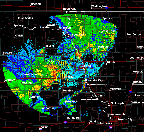 At 1112 pm cdt, severe thunderstorms were located along a line extending from near bellwood to 6 miles west of prague to near valparaiso to 6 miles southeast of pleasant dale, moving northeast at 40 mph (trained weather spotters). Hazards include 60 mph wind gusts. expect damage to roofs, siding, and trees At 1112 pm cdt, severe thunderstorms were located along a line extending from near bellwood to 6 miles west of prague to near valparaiso to 6 miles southeast of pleasant dale, moving northeast at 40 mph (trained weather spotters). Hazards include 60 mph wind gusts. expect damage to roofs, siding, and trees
|
| 6/13/2017 11:09 PM CDT |
 At 1108 pm cdt, severe thunderstorms were located along a line extending from near bellwood to 7 miles north of brainard to 6 miles north of valparaiso to 5 miles south of pleasant dale, moving northeast at 45 mph (radar indicated). Hazards include 60 mph wind gusts. Expect damage to roofs, siding, and trees. locations impacted include, seward, crete, david city, milford, friend, dorchester, valparaiso, beaver crossing, rising city, brainard, staplehurst, garland, pleasant dale, dwight, bee, ulysses, malcolm, goehner, bruno and garrison. this includes the following highways, highway 92 in nebraska between mile markers 409 and 434. Interstate 80 in nebraska between mile markers 369 and 392. At 1108 pm cdt, severe thunderstorms were located along a line extending from near bellwood to 7 miles north of brainard to 6 miles north of valparaiso to 5 miles south of pleasant dale, moving northeast at 45 mph (radar indicated). Hazards include 60 mph wind gusts. Expect damage to roofs, siding, and trees. locations impacted include, seward, crete, david city, milford, friend, dorchester, valparaiso, beaver crossing, rising city, brainard, staplehurst, garland, pleasant dale, dwight, bee, ulysses, malcolm, goehner, bruno and garrison. this includes the following highways, highway 92 in nebraska between mile markers 409 and 434. Interstate 80 in nebraska between mile markers 369 and 392.
|
| 6/13/2017 11:00 PM CDT | Lots of tree damage and limbs down. most of town without power. roof damage to at least one buildin in butler county NE, 0.5 miles NNE of David City, NE |
| 6/13/2017 10:57 PM CDT |
 At 1056 pm cdt, severe thunderstorms were located along a line extending from 4 miles southwest of rising city to 3 miles northeast of staplehurst to near dorchester, moving northeast at 35 mph (radar indicated). Hazards include 60 mph wind gusts. expect damage to roofs, siding, and trees At 1056 pm cdt, severe thunderstorms were located along a line extending from 4 miles southwest of rising city to 3 miles northeast of staplehurst to near dorchester, moving northeast at 35 mph (radar indicated). Hazards include 60 mph wind gusts. expect damage to roofs, siding, and trees
|
| 6/13/2017 9:55 PM CDT |
 The severe thunderstorm warning for northwestern lancaster, seward, butler and western saunders counties will expire at 1000 pm cdt, the storms which prompted the warning have weakened below severe limits, and no longer pose an immediate threat to life or property. therefore the warning will be allowed to expire. however nickel size hail, gusty winds and heavy rain are still possible with these thunderstorms. a severe thunderstorm watch remains in effect until 100 am cdt for southeastern and east central nebraska. The severe thunderstorm warning for northwestern lancaster, seward, butler and western saunders counties will expire at 1000 pm cdt, the storms which prompted the warning have weakened below severe limits, and no longer pose an immediate threat to life or property. therefore the warning will be allowed to expire. however nickel size hail, gusty winds and heavy rain are still possible with these thunderstorms. a severe thunderstorm watch remains in effect until 100 am cdt for southeastern and east central nebraska.
|
| 6/13/2017 9:47 PM CDT |
 At 946 pm cdt, severe thunderstorms were located along a line extending from 3 miles southwest of cedar bluffs to near valparaiso to 5 miles west of milford, moving east at 25 mph (radar indicated). Hazards include 60 mph wind gusts and quarter size hail. Hail damage to vehicles is expected. expect wind damage to roofs, siding, and trees. locations impacted include, seward, david city, milford, utica, valparaiso, beaver crossing, brainard, weston, prague, staplehurst, garland, pleasant dale, dwight, bee, ulysses, malcolm, raymond, goehner, cordova and octavia. this includes the following highways, highway 92 in nebraska between mile markers 419 and 446. Interstate 80 in nebraska between mile markers 366 and 390. At 946 pm cdt, severe thunderstorms were located along a line extending from 3 miles southwest of cedar bluffs to near valparaiso to 5 miles west of milford, moving east at 25 mph (radar indicated). Hazards include 60 mph wind gusts and quarter size hail. Hail damage to vehicles is expected. expect wind damage to roofs, siding, and trees. locations impacted include, seward, david city, milford, utica, valparaiso, beaver crossing, brainard, weston, prague, staplehurst, garland, pleasant dale, dwight, bee, ulysses, malcolm, raymond, goehner, cordova and octavia. this includes the following highways, highway 92 in nebraska between mile markers 419 and 446. Interstate 80 in nebraska between mile markers 366 and 390.
|
| 6/13/2017 9:37 PM CDT |
 At 936 pm cdt, severe thunderstorms were located along a line extending from 5 miles south of north bend to near dwight to 3 miles north of beaver crossing, moving east at 25 mph (radar indicated). Hazards include 60 mph wind gusts and quarter size hail. Hail damage to vehicles is expected. expect wind damage to roofs, siding, and trees. locations impacted include, seward, david city, milford, utica, valparaiso, beaver crossing, brainard, weston, prague, staplehurst, garland, pleasant dale, dwight, bee, ulysses, malcolm, raymond, goehner, cordova and octavia. this includes the following highways, highway 92 in nebraska between mile markers 419 and 446. Interstate 80 in nebraska between mile markers 366 and 390. At 936 pm cdt, severe thunderstorms were located along a line extending from 5 miles south of north bend to near dwight to 3 miles north of beaver crossing, moving east at 25 mph (radar indicated). Hazards include 60 mph wind gusts and quarter size hail. Hail damage to vehicles is expected. expect wind damage to roofs, siding, and trees. locations impacted include, seward, david city, milford, utica, valparaiso, beaver crossing, brainard, weston, prague, staplehurst, garland, pleasant dale, dwight, bee, ulysses, malcolm, raymond, goehner, cordova and octavia. this includes the following highways, highway 92 in nebraska between mile markers 419 and 446. Interstate 80 in nebraska between mile markers 366 and 390.
|
| 6/13/2017 9:27 PM CDT |
 At 926 pm cdt, severe thunderstorms were located along a line extending from 6 miles northeast of north bend to near dwight to 4 miles south of seward, moving east at 30 mph (radar indicated). Hazards include 60 mph wind gusts and quarter size hail. Hail damage to vehicles is expected. Expect wind damage to roofs, siding, and trees. At 926 pm cdt, severe thunderstorms were located along a line extending from 6 miles northeast of north bend to near dwight to 4 miles south of seward, moving east at 30 mph (radar indicated). Hazards include 60 mph wind gusts and quarter size hail. Hail damage to vehicles is expected. Expect wind damage to roofs, siding, and trees.
|
| 6/13/2017 9:18 PM CDT |
 At 918 pm cdt, severe thunderstorms were located along a line extending from 4 miles southwest of snyder to 5 miles southwest of prague to 4 miles west of beaver crossing, moving east at 35 mph (radar indicated). Hazards include 60 mph wind gusts and half dollar size hail. Hail damage to vehicles is expected. expect wind damage to roofs, siding, and trees. locations impacted include, fremont, seward, schuyler, wahoo, david city, milford, north bend, utica, hooper, cedar bluffs, valparaiso, bellwood, beaver crossing, rising city, brainard, inglewood, weston, prague, staplehurst and garland. this includes the following highways, highway 275 in nebraska between mile markers 135 and 140. highway 30 in nebraska between mile markers 387 and 426. highway 77 in nebraska between mile markers 90 and 93, and between mile markers 108 and 126. highway 92 in nebraska between mile markers 412 and 452. Interstate 80 in nebraska between mile markers 366 and 392. At 918 pm cdt, severe thunderstorms were located along a line extending from 4 miles southwest of snyder to 5 miles southwest of prague to 4 miles west of beaver crossing, moving east at 35 mph (radar indicated). Hazards include 60 mph wind gusts and half dollar size hail. Hail damage to vehicles is expected. expect wind damage to roofs, siding, and trees. locations impacted include, fremont, seward, schuyler, wahoo, david city, milford, north bend, utica, hooper, cedar bluffs, valparaiso, bellwood, beaver crossing, rising city, brainard, inglewood, weston, prague, staplehurst and garland. this includes the following highways, highway 275 in nebraska between mile markers 135 and 140. highway 30 in nebraska between mile markers 387 and 426. highway 77 in nebraska between mile markers 90 and 93, and between mile markers 108 and 126. highway 92 in nebraska between mile markers 412 and 452. Interstate 80 in nebraska between mile markers 366 and 392.
|
| 6/13/2017 9:07 PM CDT |
 At 906 pm cdt, severe thunderstorms were located along a line extending from 6 miles south of howells to 5 miles east of david city to 3 miles southwest of beaver crossing, moving east at 40 mph (radar indicated). Hazards include 60 mph wind gusts and quarter size hail. Hail damage to vehicles is expected. Expect wind damage to roofs, siding, and trees. At 906 pm cdt, severe thunderstorms were located along a line extending from 6 miles south of howells to 5 miles east of david city to 3 miles southwest of beaver crossing, moving east at 40 mph (radar indicated). Hazards include 60 mph wind gusts and quarter size hail. Hail damage to vehicles is expected. Expect wind damage to roofs, siding, and trees.
|
| 6/13/2017 8:59 PM CDT |
 At 859 pm cdt, severe thunderstorms were located along a line extending from 4 miles east of scribner to 3 miles south of inglewood to 5 miles south of valparaiso, moving east at 45 mph (radar indicated). Hazards include 60 mph wind gusts. Expect damage to roofs, siding, and trees. locations impacted include, fremont, schuyler, wahoo, david city, north bend, scribner, hooper, clarkson, dodge, cedar bluffs, valparaiso, howells, bellwood, rising city, nickerson, brainard, inglewood, weston, prague and snyder. this includes the following highways, highway 275 in nebraska between mile markers 124 and 156. highway 30 in nebraska between mile markers 387 and 426. highway 77 in nebraska between mile markers 90 and 93, and between mile markers 108 and 135. Highway 92 in nebraska between mile markers 409 and 446. At 859 pm cdt, severe thunderstorms were located along a line extending from 4 miles east of scribner to 3 miles south of inglewood to 5 miles south of valparaiso, moving east at 45 mph (radar indicated). Hazards include 60 mph wind gusts. Expect damage to roofs, siding, and trees. locations impacted include, fremont, schuyler, wahoo, david city, north bend, scribner, hooper, clarkson, dodge, cedar bluffs, valparaiso, howells, bellwood, rising city, nickerson, brainard, inglewood, weston, prague and snyder. this includes the following highways, highway 275 in nebraska between mile markers 124 and 156. highway 30 in nebraska between mile markers 387 and 426. highway 77 in nebraska between mile markers 90 and 93, and between mile markers 108 and 135. Highway 92 in nebraska between mile markers 409 and 446.
|
| 6/13/2017 8:42 PM CDT |
 At 840 pm cdt, severe thunderstorms were located along a line extending from dodge to near north bend to 3 miles southeast of ulysses, moving east at 45 mph. another line of storms was moving across southern platte and into western butler counties, also moving east at 45 mph (radar indicated). Hazards include 60 mph wind gusts. expect damage to roofs, siding, and trees At 840 pm cdt, severe thunderstorms were located along a line extending from dodge to near north bend to 3 miles southeast of ulysses, moving east at 45 mph. another line of storms was moving across southern platte and into western butler counties, also moving east at 45 mph (radar indicated). Hazards include 60 mph wind gusts. expect damage to roofs, siding, and trees
|
| 6/13/2017 8:32 PM CDT |
 At 831 pm cdt, severe thunderstorms were located along a line extending from near howells to 6 miles northeast of schuyler to 4 miles south of david city, moving east at 50 mph (radar indicated). Hazards include 70 mph wind gusts and nickel size hail. Expect considerable tree damage. damage is likely to mobile homes, roofs, and outbuildings. locations impacted include, schuyler, wahoo, david city, north bend, scribner, clarkson, dodge, cedar bluffs, valparaiso, howells, bellwood, rising city, brainard, weston, prague, snyder, dwight, ulysses, morse bluff and octavia. this includes the following highways, highway 275 in nebraska between mile markers 127 and 132. highway 30 in nebraska between mile markers 387 and 420. highway 77 in nebraska between mile markers 85 and 93. Highway 92 in nebraska between mile markers 409 and 446. At 831 pm cdt, severe thunderstorms were located along a line extending from near howells to 6 miles northeast of schuyler to 4 miles south of david city, moving east at 50 mph (radar indicated). Hazards include 70 mph wind gusts and nickel size hail. Expect considerable tree damage. damage is likely to mobile homes, roofs, and outbuildings. locations impacted include, schuyler, wahoo, david city, north bend, scribner, clarkson, dodge, cedar bluffs, valparaiso, howells, bellwood, rising city, brainard, weston, prague, snyder, dwight, ulysses, morse bluff and octavia. this includes the following highways, highway 275 in nebraska between mile markers 127 and 132. highway 30 in nebraska between mile markers 387 and 420. highway 77 in nebraska between mile markers 85 and 93. Highway 92 in nebraska between mile markers 409 and 446.
|
| 6/13/2017 8:21 PM CDT |
 At 821 pm cdt, severe thunderstorms were located along a line extending from 3 miles southwest of clarkson to 3 miles west of schuyler to 3 miles northeast of ulysses, moving east at 50 mph (trained weather spotters). Hazards include 70 mph wind gusts and nickel size hail. Expect considerable tree damage. Damage is likely to mobile homes, roofs, and outbuildings. At 821 pm cdt, severe thunderstorms were located along a line extending from 3 miles southwest of clarkson to 3 miles west of schuyler to 3 miles northeast of ulysses, moving east at 50 mph (trained weather spotters). Hazards include 70 mph wind gusts and nickel size hail. Expect considerable tree damage. Damage is likely to mobile homes, roofs, and outbuildings.
|
| 6/13/2017 8:17 PM CDT |
 At 816 pm cdt, severe thunderstorms were located along a line extending from 5 miles south of creston to 4 miles north of bellwood to 4 miles north of rising city, moving east at 50 mph (trained weather spotters). Hazards include 70 mph wind gusts and quarter size hail. Hail damage to vehicles is expected. expect considerable tree damage. wind damage is also likely to mobile homes, roofs, and outbuildings. locations impacted include, columbus, schuyler, david city, bellwood, octavia, bruno, linwood, richland, abie, college view trailer park, camp pawnee, shell creek elementary school, lake north babcock campground, 9 miles north of schuyler, central community college, circle h trailer park and camp luther. this includes the following highways, highway 30 in nebraska between mile markers 372 and 402. Highway 81 in nebraska between mile markers 110 and 116. At 816 pm cdt, severe thunderstorms were located along a line extending from 5 miles south of creston to 4 miles north of bellwood to 4 miles north of rising city, moving east at 50 mph (trained weather spotters). Hazards include 70 mph wind gusts and quarter size hail. Hail damage to vehicles is expected. expect considerable tree damage. wind damage is also likely to mobile homes, roofs, and outbuildings. locations impacted include, columbus, schuyler, david city, bellwood, octavia, bruno, linwood, richland, abie, college view trailer park, camp pawnee, shell creek elementary school, lake north babcock campground, 9 miles north of schuyler, central community college, circle h trailer park and camp luther. this includes the following highways, highway 30 in nebraska between mile markers 372 and 402. Highway 81 in nebraska between mile markers 110 and 116.
|
| 6/13/2017 8:05 PM CDT |
 At 804 pm cdt, severe thunderstorms were located along a line extending from 6 miles north of monroe to near duncan to near osceola, moving east at 40 mph (radar indicated). Hazards include 60 mph wind gusts and quarter size hail. Hail damage to vehicles is expected. Expect wind damage to roofs, siding, and trees. At 804 pm cdt, severe thunderstorms were located along a line extending from 6 miles north of monroe to near duncan to near osceola, moving east at 40 mph (radar indicated). Hazards include 60 mph wind gusts and quarter size hail. Hail damage to vehicles is expected. Expect wind damage to roofs, siding, and trees.
|
| 6/12/2017 9:20 AM CDT |
 At 920 am cdt, a severe thunderstorm was located over david city, or 16 miles southeast of columbus, moving north at 25 mph (radar indicated). Hazards include 60 mph wind gusts and quarter size hail. Hail damage to vehicles is expected. expect wind damage to roofs, siding, and trees. locations impacted include, david city, bellwood, rising city, brainard, octavia, bruno and garrison. This includes highway 92 in nebraska between mile markers 409 and 430. At 920 am cdt, a severe thunderstorm was located over david city, or 16 miles southeast of columbus, moving north at 25 mph (radar indicated). Hazards include 60 mph wind gusts and quarter size hail. Hail damage to vehicles is expected. expect wind damage to roofs, siding, and trees. locations impacted include, david city, bellwood, rising city, brainard, octavia, bruno and garrison. This includes highway 92 in nebraska between mile markers 409 and 430.
|
| 6/12/2017 9:11 AM CDT |
 At 910 am cdt, a severe thunderstorm was located 4 miles south of david city, or 20 miles southeast of columbus, moving north at 25 mph (radar indicated). Hazards include 60 mph wind gusts and quarter size hail. Hail damage to vehicles is expected. expect wind damage to roofs, siding, and trees. locations impacted include, david city, bellwood, rising city, brainard, octavia, bruno, garrison and surprise. This includes highway 92 in nebraska between mile markers 409 and 430. At 910 am cdt, a severe thunderstorm was located 4 miles south of david city, or 20 miles southeast of columbus, moving north at 25 mph (radar indicated). Hazards include 60 mph wind gusts and quarter size hail. Hail damage to vehicles is expected. expect wind damage to roofs, siding, and trees. locations impacted include, david city, bellwood, rising city, brainard, octavia, bruno, garrison and surprise. This includes highway 92 in nebraska between mile markers 409 and 430.
|
| 6/12/2017 9:05 AM CDT |
 At 904 am cdt, a severe thunderstorm was located 5 miles northeast of ulysses, or 22 miles southeast of columbus, moving north at 25 mph (radar indicated). Hazards include 60 mph wind gusts and quarter size hail. Hail damage to vehicles is expected. expect wind damage to roofs, siding, and trees. locations impacted include, david city, bellwood, rising city, brainard, dwight, ulysses, octavia, bruno, abie, garrison and surprise. This includes highway 92 in nebraska between mile markers 409 and 433. At 904 am cdt, a severe thunderstorm was located 5 miles northeast of ulysses, or 22 miles southeast of columbus, moving north at 25 mph (radar indicated). Hazards include 60 mph wind gusts and quarter size hail. Hail damage to vehicles is expected. expect wind damage to roofs, siding, and trees. locations impacted include, david city, bellwood, rising city, brainard, dwight, ulysses, octavia, bruno, abie, garrison and surprise. This includes highway 92 in nebraska between mile markers 409 and 433.
|
| 6/12/2017 8:56 AM CDT |
 At 855 am cdt, a severe thunderstorm was located over ulysses, or 26 miles south of columbus, moving north at 25 mph (radar indicated). Hazards include ping pong ball size hail and 60 mph wind gusts. People and animals outdoors will be injured. expect hail damage to roofs, siding, windows, and vehicles. Expect wind damage to roofs, siding, and trees. At 855 am cdt, a severe thunderstorm was located over ulysses, or 26 miles south of columbus, moving north at 25 mph (radar indicated). Hazards include ping pong ball size hail and 60 mph wind gusts. People and animals outdoors will be injured. expect hail damage to roofs, siding, windows, and vehicles. Expect wind damage to roofs, siding, and trees.
|
| 5/17/2017 2:20 AM CDT |
 At 220 am cdt, severe thunderstorms were located along a line extending from 4 miles north of ulysses to near seward to 5 miles south of dorchester, moving northeast at 55 mph (radar indicated). Hazards include 60 mph wind gusts. Expect damage to roofs, siding, and trees. locations impacted include, seward, crete, david city, milford, dorchester, bellwood, rising city, brainard, staplehurst, garland, pleasant dale, dwight, bee, ulysses, goehner, octavia, bruno, abie, garrison and surprise. this includes the following highways, highway 92 in nebraska between mile markers 409 and 430. Interstate 80 in nebraska between mile markers 371 and 388. At 220 am cdt, severe thunderstorms were located along a line extending from 4 miles north of ulysses to near seward to 5 miles south of dorchester, moving northeast at 55 mph (radar indicated). Hazards include 60 mph wind gusts. Expect damage to roofs, siding, and trees. locations impacted include, seward, crete, david city, milford, dorchester, bellwood, rising city, brainard, staplehurst, garland, pleasant dale, dwight, bee, ulysses, goehner, octavia, bruno, abie, garrison and surprise. this includes the following highways, highway 92 in nebraska between mile markers 409 and 430. Interstate 80 in nebraska between mile markers 371 and 388.
|
| 5/17/2017 2:09 AM CDT |
 At 209 am cdt, severe thunderstorms were located along a line extending from near gresham to 5 miles northeast of beaver crossing to 7 miles east of milligan, moving east at 60 mph (radar indicated). Hazards include 60 mph wind gusts. Expect damage to roofs, siding, and trees. locations impacted include, seward, crete, david city, milford, friend, utica, dorchester, bellwood, beaver crossing, rising city, brainard, staplehurst, garland, pleasant dale, dwight, bee, ulysses, goehner, cordova and octavia. this includes the following highways, highway 92 in nebraska between mile markers 409 and 430. Interstate 80 in nebraska between mile markers 366 and 388. At 209 am cdt, severe thunderstorms were located along a line extending from near gresham to 5 miles northeast of beaver crossing to 7 miles east of milligan, moving east at 60 mph (radar indicated). Hazards include 60 mph wind gusts. Expect damage to roofs, siding, and trees. locations impacted include, seward, crete, david city, milford, friend, utica, dorchester, bellwood, beaver crossing, rising city, brainard, staplehurst, garland, pleasant dale, dwight, bee, ulysses, goehner, cordova and octavia. this includes the following highways, highway 92 in nebraska between mile markers 409 and 430. Interstate 80 in nebraska between mile markers 366 and 388.
|
| 5/17/2017 1:58 AM CDT |
 At 157 am cdt, severe thunderstorms were located along a line extending from 3 miles northeast of benedict to 4 miles south of utica to 3 miles north of milligan, moving northeast at 65 mph (radar indicated). Hazards include 60 mph wind gusts. expect damage to roofs, siding, and trees At 157 am cdt, severe thunderstorms were located along a line extending from 3 miles northeast of benedict to 4 miles south of utica to 3 miles north of milligan, moving northeast at 65 mph (radar indicated). Hazards include 60 mph wind gusts. expect damage to roofs, siding, and trees
|
| 11/27/2016 5:47 PM CST |
 At 547 pm cst, a severe thunderstorm was located near ulysses, or 24 miles southeast of columbus, moving northeast at 55 mph (radar indicated). Hazards include 60 mph wind gusts and quarter size hail. Hail damage to vehicles is expected. expect wind damage to roofs, siding, and trees. locations impacted include, david city, brainard, staplehurst, dwight, ulysses, octavia, bruno, abie, garrison and surprise. This includes highway 92 in nebraska between mile markers 415 and 434. At 547 pm cst, a severe thunderstorm was located near ulysses, or 24 miles southeast of columbus, moving northeast at 55 mph (radar indicated). Hazards include 60 mph wind gusts and quarter size hail. Hail damage to vehicles is expected. expect wind damage to roofs, siding, and trees. locations impacted include, david city, brainard, staplehurst, dwight, ulysses, octavia, bruno, abie, garrison and surprise. This includes highway 92 in nebraska between mile markers 415 and 434.
|
| 11/27/2016 5:32 PM CST |
 At 532 pm cst, a severe thunderstorm was located near utica, or 14 miles east of york, moving northeast at 55 mph (radar indicated). Hazards include 60 mph wind gusts and quarter size hail. Hail damage to vehicles is expected. Expect wind damage to roofs, siding, and trees. At 532 pm cst, a severe thunderstorm was located near utica, or 14 miles east of york, moving northeast at 55 mph (radar indicated). Hazards include 60 mph wind gusts and quarter size hail. Hail damage to vehicles is expected. Expect wind damage to roofs, siding, and trees.
|
| 9/16/2016 12:21 AM CDT |
 The severe thunderstorm warning for eastern butler and western saunders counties will expire at 1230 am cdt, the storm which prompted the warning has weakened below severe limits, and no longer poses an immediate threat to life or property. therefore, the warning will be allowed to expire. however gusty winds and heavy rain are still possible with this thunderstorm. The severe thunderstorm warning for eastern butler and western saunders counties will expire at 1230 am cdt, the storm which prompted the warning has weakened below severe limits, and no longer poses an immediate threat to life or property. therefore, the warning will be allowed to expire. however gusty winds and heavy rain are still possible with this thunderstorm.
|
| 9/16/2016 12:11 AM CDT |
 At 1211 am cdt, a severe thunderstorm was located 6 miles southwest of prague, or 28 miles southeast of columbus, moving east at 40 mph (radar indicated). Hazards include 60 mph wind gusts and nickel size hail. Expect damage to roofs. siding. and trees. locations impacted include, wahoo, david city, valparaiso, brainard, weston, prague, dwight, ceresco, octavia, malmo, colon, bruno and abie. this includes the following highways, highway 77 in nebraska between milemarkers 82 and 93. Highway 92 in nebraska between mile markers 423 and 446. At 1211 am cdt, a severe thunderstorm was located 6 miles southwest of prague, or 28 miles southeast of columbus, moving east at 40 mph (radar indicated). Hazards include 60 mph wind gusts and nickel size hail. Expect damage to roofs. siding. and trees. locations impacted include, wahoo, david city, valparaiso, brainard, weston, prague, dwight, ceresco, octavia, malmo, colon, bruno and abie. this includes the following highways, highway 77 in nebraska between milemarkers 82 and 93. Highway 92 in nebraska between mile markers 423 and 446.
|
| 9/16/2016 12:05 AM CDT |
 At 1204 am cdt, a severe thunderstorm was located over brainard, or 25 miles southeast of columbus, moving east at 30 mph (radar indicated). Hazards include 60 mph wind gusts and nickel size hail. Expect damage to roofs. siding. and trees. locations impacted include, wahoo, david city, valparaiso, brainard, weston, prague, dwight, ceresco, octavia, malmo, colon, bruno, abie and garrison. this includes the following highways, highway 77 in nebraska between milemarkers 82 and 93. Highway 92 in nebraska between mile markers 419 and 446. At 1204 am cdt, a severe thunderstorm was located over brainard, or 25 miles southeast of columbus, moving east at 30 mph (radar indicated). Hazards include 60 mph wind gusts and nickel size hail. Expect damage to roofs. siding. and trees. locations impacted include, wahoo, david city, valparaiso, brainard, weston, prague, dwight, ceresco, octavia, malmo, colon, bruno, abie and garrison. this includes the following highways, highway 77 in nebraska between milemarkers 82 and 93. Highway 92 in nebraska between mile markers 419 and 446.
|
| 9/15/2016 11:58 PM CDT |
 At 1158 pm cdt, a severe thunderstorm was located near brainard, or 26 miles southeast of columbus, moving east at 35 mph. this storm does have some rotation (radar indicated). Hazards include 60 mph wind gusts and quarter size hail. Hail damage to vehicles is expected. expect wind damage to roofs, siding, and trees. locations impacted include, wahoo, david city, valparaiso, bellwood, brainard, weston, prague, dwight, ulysses, ceresco, octavia, malmo, colon, bruno, abie and garrison. this includes the following highways, highway 77 in nebraska between milemarkers 82 and 93. Highway 92 in nebraska between mile markers 415 and 446. At 1158 pm cdt, a severe thunderstorm was located near brainard, or 26 miles southeast of columbus, moving east at 35 mph. this storm does have some rotation (radar indicated). Hazards include 60 mph wind gusts and quarter size hail. Hail damage to vehicles is expected. expect wind damage to roofs, siding, and trees. locations impacted include, wahoo, david city, valparaiso, bellwood, brainard, weston, prague, dwight, ulysses, ceresco, octavia, malmo, colon, bruno, abie and garrison. this includes the following highways, highway 77 in nebraska between milemarkers 82 and 93. Highway 92 in nebraska between mile markers 415 and 446.
|
| 9/15/2016 11:51 PM CDT |
 At 1151 pm cdt, a severe thunderstorm was located 5 miles south of david city, or 21 miles southeast of columbus, moving east at 35 mph (radar indicated). Hazards include 60 mph wind gusts and quarter size hail. Hail damage to vehicles is expected. expect wind damage to roofs, siding, and trees. locations impacted include, wahoo, david city, valparaiso, bellwood, brainard, weston, prague, dwight, ulysses, ceresco, octavia, malmo, colon, bruno, abie and garrison. this includes the following highways, highway 77 in nebraska between milemarkers 82 and 93. Highway 92 in nebraska between mile markers 415 and 446. At 1151 pm cdt, a severe thunderstorm was located 5 miles south of david city, or 21 miles southeast of columbus, moving east at 35 mph (radar indicated). Hazards include 60 mph wind gusts and quarter size hail. Hail damage to vehicles is expected. expect wind damage to roofs, siding, and trees. locations impacted include, wahoo, david city, valparaiso, bellwood, brainard, weston, prague, dwight, ulysses, ceresco, octavia, malmo, colon, bruno, abie and garrison. this includes the following highways, highway 77 in nebraska between milemarkers 82 and 93. Highway 92 in nebraska between mile markers 415 and 446.
|
| 9/15/2016 11:44 PM CDT |
 At 1144 pm cdt, a severe thunderstorm was located 5 miles south of david city, or 20 miles southeast of columbus, moving east at 40 mph (radar indicated). Hazards include 60 mph wind gusts and quarter size hail. Hail damage to vehicles is expected. Expect wind damage to roofs, siding, and trees. At 1144 pm cdt, a severe thunderstorm was located 5 miles south of david city, or 20 miles southeast of columbus, moving east at 40 mph (radar indicated). Hazards include 60 mph wind gusts and quarter size hail. Hail damage to vehicles is expected. Expect wind damage to roofs, siding, and trees.
|
| 8/2/2016 2:21 AM CDT |
 At 221 am cdt, severe thunderstorms were located along a line extending from 7 miles northeast of david city to near brainard to 3 miles northwest of bee, moving east at 40 mph (radar indicated). Hazards include 60 mph wind gusts. Expect damage to roofs. siding. And trees. At 221 am cdt, severe thunderstorms were located along a line extending from 7 miles northeast of david city to near brainard to 3 miles northwest of bee, moving east at 40 mph (radar indicated). Hazards include 60 mph wind gusts. Expect damage to roofs. siding. And trees.
|
| 7/5/2016 9:24 PM CDT |
 At 923 pm cdt, severe thunderstorms were located along a line extending from 4 miles south of snyder to 6 miles northwest of prague, moving east at 45 mph. the strongest winds are likely from along the platte river northward into colfax and dodge counties. these are very dangerous storms (radar indicated). Hazards include 80 mph wind gusts and quarter size hail. Flying debris will be dangerous to those caught without shelter. mobile homes will be heavily damaged. expect considerable damage to roofs, windows and vehicles. extensive tree damage and power outages are likely. locations impacted include, schuyler, david city, north bend, prague, morse bluff, octavia, malmo, bruno, rogers, linwood, abie, 7 miles north of north bend and 9 miles north of schuyler. This includes highway 30 in nebraska between mile markers 393 and 414. At 923 pm cdt, severe thunderstorms were located along a line extending from 4 miles south of snyder to 6 miles northwest of prague, moving east at 45 mph. the strongest winds are likely from along the platte river northward into colfax and dodge counties. these are very dangerous storms (radar indicated). Hazards include 80 mph wind gusts and quarter size hail. Flying debris will be dangerous to those caught without shelter. mobile homes will be heavily damaged. expect considerable damage to roofs, windows and vehicles. extensive tree damage and power outages are likely. locations impacted include, schuyler, david city, north bend, prague, morse bluff, octavia, malmo, bruno, rogers, linwood, abie, 7 miles north of north bend and 9 miles north of schuyler. This includes highway 30 in nebraska between mile markers 393 and 414.
|
| 7/5/2016 9:16 PM CDT |
 At 916 pm cdt, severe thunderstorms were located along a line extending from 7 miles south of dodge to 6 miles southeast of schuyler, moving east at 45 mph. these are very dangerous storms (radar indicated). Hazards include 80 mph wind gusts and quarter size hail. Flying debris will be dangerous to those caught without shelter. mobile homes will be heavily damaged. expect considerable damage to roofs, windows and vehicles. extensive tree damage and power outages are likely. locations impacted include, schuyler, david city, north bend, prague, morse bluff, octavia, malmo, bruno, rogers, linwood, abie, 7 miles north of north bend and 9 miles north of schuyler. This includes highway 30 in nebraska between mile markers 393 and 414. At 916 pm cdt, severe thunderstorms were located along a line extending from 7 miles south of dodge to 6 miles southeast of schuyler, moving east at 45 mph. these are very dangerous storms (radar indicated). Hazards include 80 mph wind gusts and quarter size hail. Flying debris will be dangerous to those caught without shelter. mobile homes will be heavily damaged. expect considerable damage to roofs, windows and vehicles. extensive tree damage and power outages are likely. locations impacted include, schuyler, david city, north bend, prague, morse bluff, octavia, malmo, bruno, rogers, linwood, abie, 7 miles north of north bend and 9 miles north of schuyler. This includes highway 30 in nebraska between mile markers 393 and 414.
|
| 7/5/2016 9:09 PM CDT |
 At 909 pm cdt, severe thunderstorms were located along a line extending from 5 miles south of howells to david city, moving east at 45 mph. strong winds are occurring out ahead of the rain and hail (radar indicated). Hazards include 70 mph wind gusts and quarter size hail. Hail damage to vehicles is expected. expect considerable tree damage. Wind damage is also likely to mobile homes, roofs and outbuildings. At 909 pm cdt, severe thunderstorms were located along a line extending from 5 miles south of howells to david city, moving east at 45 mph. strong winds are occurring out ahead of the rain and hail (radar indicated). Hazards include 70 mph wind gusts and quarter size hail. Hail damage to vehicles is expected. expect considerable tree damage. Wind damage is also likely to mobile homes, roofs and outbuildings.
|
| 6/21/2016 4:25 AM CDT |
 At 425 am cdt, a severe thunderstorm was located 6 miles north of david city, or 15 miles southeast of columbus, moving southeast at 20 mph (radar indicated). Hazards include half dollar size hail. damage to vehicles is expected At 425 am cdt, a severe thunderstorm was located 6 miles north of david city, or 15 miles southeast of columbus, moving southeast at 20 mph (radar indicated). Hazards include half dollar size hail. damage to vehicles is expected
|
| 5/10/2016 11:16 PM CDT |
 At 1115 pm cdt, a severe thunderstorm was located 8 miles north of brainard, or 22 miles southeast of columbus, moving northeast at 30 mph (radar indicated). Hazards include 60 mph wind gusts and nickel size hail. Expect damage to roofs. siding and trees. locations impacted include, prague, octavia, bruno, rogers, linwood and abie. this includes the following highways, highway 30 in nebraska near mile marker 402. Highway 92 in nebraska between mile markers 425 and 428. At 1115 pm cdt, a severe thunderstorm was located 8 miles north of brainard, or 22 miles southeast of columbus, moving northeast at 30 mph (radar indicated). Hazards include 60 mph wind gusts and nickel size hail. Expect damage to roofs. siding and trees. locations impacted include, prague, octavia, bruno, rogers, linwood and abie. this includes the following highways, highway 30 in nebraska near mile marker 402. Highway 92 in nebraska between mile markers 425 and 428.
|
| 5/10/2016 10:55 PM CDT |
 At 1055 pm cdt, a severe thunderstorm was located near david city, or 20 miles southeast of columbus, moving northeast at 30 mph (radar indicated). Hazards include 60 mph wind gusts and nickel size hail. Expect damage to roofs. Siding and trees. At 1055 pm cdt, a severe thunderstorm was located near david city, or 20 miles southeast of columbus, moving northeast at 30 mph (radar indicated). Hazards include 60 mph wind gusts and nickel size hail. Expect damage to roofs. Siding and trees.
|
| 8/2/2015 7:21 PM CDT |
 The severe thunderstorm warning for central butler county will expire at 730 pm cdt, the storm which prompted the warning has exited the warned area. therefore the warning will be allowed to expire. The severe thunderstorm warning for central butler county will expire at 730 pm cdt, the storm which prompted the warning has exited the warned area. therefore the warning will be allowed to expire.
|
| 8/2/2015 7:17 PM CDT |
 At 716 pm cdt, a severe thunderstorm was located near brainard, or 21 miles southeast of columbus, moving southeast at 30 mph (radar indicated). Hazards include quarter size hail. Damage to vehicles is expected. locations impacted include, david city and brainard. This includes highway 92 in nebraska between mile markers 423 and 430. At 716 pm cdt, a severe thunderstorm was located near brainard, or 21 miles southeast of columbus, moving southeast at 30 mph (radar indicated). Hazards include quarter size hail. Damage to vehicles is expected. locations impacted include, david city and brainard. This includes highway 92 in nebraska between mile markers 423 and 430.
|
| 8/2/2015 7:06 PM CDT |
 At 706 pm cdt, a severe thunderstorm was located over david city, or 19 miles southeast of columbus, moving southeast at 25 mph (radar indicated). Hazards include quarter size hail. Damage to vehicles is expected. locations impacted include, david city, bellwood, brainard, dwight and garrison. This includes highway 92 in nebraska between mile markers 419 and 430. At 706 pm cdt, a severe thunderstorm was located over david city, or 19 miles southeast of columbus, moving southeast at 25 mph (radar indicated). Hazards include quarter size hail. Damage to vehicles is expected. locations impacted include, david city, bellwood, brainard, dwight and garrison. This includes highway 92 in nebraska between mile markers 419 and 430.
|
| 8/2/2015 6:31 PM CDT |
 At 631 pm cdt, a severe thunderstorm was located near david city, or 13 miles southeast of columbus, moving southeast at 10 mph (radar indicated). Hazards include quarter size hail. damage to vehicles is expected At 631 pm cdt, a severe thunderstorm was located near david city, or 13 miles southeast of columbus, moving southeast at 10 mph (radar indicated). Hazards include quarter size hail. damage to vehicles is expected
|
| 7/24/2015 11:28 PM CDT |
 At 1128 pm cdt, severe thunderstorms were located along a line extending from near shelby to near bruning, moving east at 40 mph (radar indicated). Hazards include 60 mph wind gusts. Expect damage to roofs. Siding and trees. At 1128 pm cdt, severe thunderstorms were located along a line extending from near shelby to near bruning, moving east at 40 mph (radar indicated). Hazards include 60 mph wind gusts. Expect damage to roofs. Siding and trees.
|
| 6/4/2015 7:56 PM CDT | At 756 pm cdt, a severe thunderstorm was located near rising city, or 22 miles northeast of york, moving east at 15 mph (radar indicated). Hazards include half dollar size hail. Damage to vehicles is expected. locations impacted include, david city, rising city, brainard, dwight, ulysses, bruno, garrison and surprise. This includes highway 92 in nebraska between mile markers 409 and 433, and between mile markers 409 and 433. |
| 6/4/2015 7:40 PM CDT | At 740 pm cdt, a severe thunderstorm was located near shelby, or 20 miles northeast of york, moving east at 30 mph (radar indicated). Hazards include half dollar size hail. damage to vehicles is expected |
| 5/6/2015 7:21 PM CDT | The severe thunderstorm warning for butler county will expire at 730 pm cdt, the storm which prompted the warning has weakened below severe limits, and no longer poses an immediate threat to life or property. therefore the warning will be allowed to expire. however gusty winds are still possible with this thunderstorm. |
| 5/6/2015 7:13 PM CDT | At 712 pm cdt, a severe thunderstorm was located near brainard, or 22 miles southeast of columbus, moving north at 50 mph (radar indicated). Hazards include 60 mph wind gusts and penny size hail. Expect damage to roofs. siding and trees. locations impacted include, david city, rising city, brainard, dwight, ulysses, garrison and surprise. this includes highway 92 in nebraska between mile markers 409 and 430, and between mile markers 409 and 428. 0. 75in. |
| 5/6/2015 7:06 PM CDT | At 706 pm cdt, a severe thunderstorm was located near ulysses, or 25 miles southeast of columbus, moving north at 50 mph (radar indicated). Hazards include 60 mph wind gusts and penny size hail. Expect damage to roofs. siding and trees. locations impacted include, seward, david city, rising city, brainard, staplehurst, garland, dwight, bee, ulysses, garrison and surprise. this includes highway 92 in nebraska between mile markers 409 and 430, and between mile markers 409 and 428. a tornado watch remains in effect until 900 pm cdt for southeastern nebraska. 0. 75in. |
| 5/6/2015 6:57 PM CDT | At 656 pm cdt, a severe thunderstorm was located over staplehurst, or 24 miles east of york, moving north at 50 mph (radar indicated). Hazards include 60 mph wind gusts and penny size hail. Expect damage to roofs. Siding and trees. |
| 5/2/2015 11:19 PM CDT | At 1118 pm cdt, severe thunderstorms were located along a line extending from near bellwood to near david city, moving east at 25 mph (radar indicated). Hazards include half dollar size hail. damage to vehicles is expected |
| 4/12/2015 7:11 PM CDT | The severe thunderstorm warning for central butler county will expire at 715 pm cdt. the storm which prompted the warning has weakened below severe limits. and no longer poses an immediate threat to life or property. therefore the warning will be allowed to expire. However hail up to nickel size is still possible with thunderstorms as they. |
| 4/12/2015 6:58 PM CDT | A severe thunderstorm warning remains in effect until 715 pm cdt for central butler county. at 657 pm cdt. a severe thunderstorm was located over brainard. or 23 miles southeast of columbus. moving northeast at 20 mph. hazard. quarter size hail. source. Radar indicated. |
| 4/12/2015 6:44 PM CDT | A severe thunderstorm warning remains in effect until 715 pm cdt for butler county. at 643 pm cdt. a severe thunderstorm was located near brainard. or 22 miles southeast of columbus. moving east at 35 mph. Other strong thunderstorms were moving into the western portion of butler county and could also product hail up to quarter size. |
| 4/12/2015 6:27 PM CDT | The national weather service in omaha has issued a * severe thunderstorm warning for. butler county in east central nebraska. until 715 pm cdt * at 627 pm cdt. a severe thunderstorm was located over rising city. or 18 miles south of columbus. Moving northeast at 25 mph. |
| 4/12/2015 6:18 PM CDT | A severe thunderstorm warning remains in effect until 630 pm cdt for western butler county. at 618 pm cdt. a severe thunderstorm was located over rising city. or 18 miles south of columbus. moving northeast at 25 mph. hazard. quarter size hail. source. Radar indicated. |
| 4/12/2015 6:04 PM CDT | The national weather service in omaha has issued a * severe thunderstorm warning for. western butler county in east central nebraska. until 630 pm cdt * at 604 pm cdt. a severe thunderstorm was located near shelby. or 19 miles south of columbus. Moving north at 30 mph. |
| 8/31/2014 6:01 PM CDT | Quarter sized hail reported 0.5 miles NNE of David City, NE |
| 8/31/2014 5:57 PM CDT | Golf Ball sized hail reported 5.6 miles NNE of David City, NE |
| 6/3/2014 6:53 PM CDT | Golf Ball sized hail reported 0.5 miles NNE of David City, NE |
| 6/3/2014 6:53 PM CDT | Storm damage reported in butler county NE, 0.5 miles NNE of David City, NE |
| 4/9/2013 5:45 PM CDT | Quarter sized hail reported 0.5 miles NNE of David City, NE, mostly nickel size with a few quarters. |
| 5/27/2012 6:52 PM CDT | Golf Ball sized hail reported 0.5 miles NNE of David City, NE, up to golfball size hail but mostly ping pong and smaller. |
| 1/1/0001 12:00 AM | Quarter sized hail reported 3.4 miles NE of David City, NE |
| 1/1/0001 12:00 AM | Quarter sized hail reported 0.5 miles NNE of David City, NE |
| 1/1/0001 12:00 AM | Storm damage reported in butler county NE, 1.9 miles SE of David City, NE |
| 1/1/0001 12:00 AM | Quarter sized hail reported 6.8 miles SSW of David City, NE, mostly nickel size hail fell for a short time. |
| 1/1/0001 12:00 AM | Quarter sized hail reported 0.5 miles NNE of David City, NE |
| 1/1/0001 12:00 AM | Whole tree blown down on 10 in butler county NE, 0.5 miles NNE of David City, NE |
Hail Maps for David City, NE
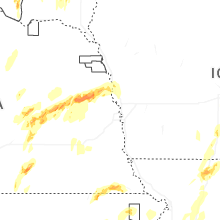


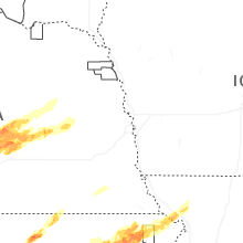


Connect with Interactive Hail Maps