

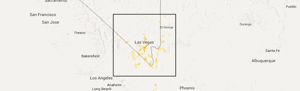
Hail Map for Thursday, June 30, 2016
Number of Impacted Households on 6/30/2016
0
Impacted by 1" or Larger Hail
0
Impacted by 1.75" or Larger Hail
0
Impacted by 2.5" or Larger Hail
Square Miles of Populated Area Impacted on 6/30/2016
0
Impacted by 1" or Larger Hail
0
Impacted by 1.75" or Larger Hail
0
Impacted by 2.5" or Larger Hail


Cities Most Affected by Hail Storms of 6/30/2016
| Hail Size | Demographics of Zip Codes Affected | ||||||
|---|---|---|---|---|---|---|---|
| City | Count | Average | Largest | Pop Density | House Value | Income | Age |
| Las Vegas, NV | 2 | 1.88 | 2.00 | 1984 | $171k | $51.6k | 37.0 |
| Kanorado, KS | 1 | 1.75 | 1.75 | 1 | $51k | $26.9k | 48.3 |
| Kremlin, MT | 1 | 1.75 | 1.75 | 0 | $69k | $31.9k | 49.3 |
Hail and Wind Damage Spotted on 6/30/2016
Filter by Report Type:Hail ReportsWind Reports
States Impacted
Florida, Minnesota, Nebraska, South Carolina, Wisconsin, Utah, Iowa, Montana, Idaho, Georgia, Nevada, Kansas, Texas, Missouri, Colorado, Oklahoma, Arizona, Virginia, North CarolinaFlorida
| Local Time | Report Details |
|---|---|
| 1:35 PM EDT | One tree down reported down at mud lake road and highway 12 in baker county FL, 31.7 miles WSW of Jacksonville, FL |
Minnesota
| Local Time | Report Details |
|---|---|
| 12:53 PM CDT | Reported at waseca airpor in waseca county MN, 63.2 miles S of Minneapolis, MN |
Nebraska
| Local Time | Report Details |
|---|---|
| 12:58 PM CDT | Quarter sized hail reported near Pender, NE, 70.6 miles NW of Omaha, NE, nickel to quarter sized hail near pender. |
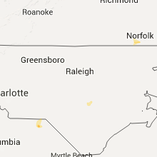
South Carolina
| Local Time | Report Details |
|---|---|
| 2:30 PM EDT | Quarter sized hail reported near Abbeville, SC, 42 miles SSE of Greenville, SC |
| 2:58 PM EDT | Quarter sized hail reported near Ware Shoals, SC, 36.7 miles SE of Greenville, SC, media relayed public video of hail storm containing quarter size stones. |
| 3:05 PM EDT | Schp reported a tree down at reedy creek rd and county line rd in greenwood county SC, 39.8 miles NNW of Augusta, GA |
| 3:10 PM EDT | Quarter sized hail reported near Ware Shoals, SC, 36.7 miles SE of Greenville, SC, public reports quarter size hail. |
| 3:35 PM EDT | Fox 5 carolina relayed report of siding blown off an outbuilding and a couple of trees dow in laurens county SC, 31.7 miles SE of Greenville, SC |
| 7:16 PM EDT | Quarter sized hail reported near Cheraw, SC, 70.6 miles SE of Charlotte, NC, quarter-size hail along hwy 52 near camp coker rd. |
| 7:28 PM EDT | Report of trees across roadway hwy 52 and hwy in chesterfield county SC, 65.4 miles SE of Charlotte, NC |
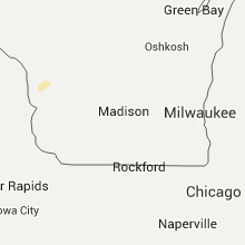
Wisconsin
| Local Time | Report Details |
|---|---|
| 1:42 PM CDT | Tree uprooted on main st between 21st and 22nd st. also a tree down near the alpine inn on bliss roa in la crosse county WI, 1.6 miles NE of La Crosse, WI |
| 3:15 PM CDT | One tree and large limbs and branches down. pea size hail. over 1 inch of rain in 45 mintue in vernon county WI, 9.7 miles SSE of La Crosse, WI |
| 3:30 PM CDT | Trees and power lines reported down in viroqu in vernon county WI, 25.2 miles SE of La Crosse, WI |
| 6:45 PM CDT | Quarter sized hail reported near Marathon, WI, 51.9 miles SSW of Rhinelander, WI |
Utah
| Local Time | Report Details |
|---|---|
| 1:25 PM MDT | Brimstone reservoir mesonet site in beaver county UT, 70.7 miles WSW of Monroe, UT |
| 5:55 PM MDT | Causeway mesonet site in tooele county UT, 94.4 miles NE of Ely, NV |
| 6:10 PM MDT | I-80 milepost 29 in tooele county UT, 84.6 miles W of Salt Lake City, UT |
| 6:45 PM MDT | Diddle knoll mesonet site in tooele county UT, 67 miles W of Salt Lake City, UT |
| 7:20 PM MDT | Causeway mesonet site in tooele county UT, 94.9 miles NE of Ely, NV |
Iowa
| Local Time | Report Details |
|---|---|
| 2:30 PM CDT | Public reported multiple instances of tree damage including numerous branches down. relayed via kwwl. time radar estimate in bremer county IA, 55.1 miles SE of Mason City, IA |
Montana
| Local Time | Report Details |
|---|---|
| 1:37 PM MDT | Quarter sized hail reported near Choteau, MT, 63.3 miles WNW of Great Falls, MT, marble to quarter size hail lasted about 2 minutes |
| 3:41 PM MDT | Quarter sized hail reported near Choteau, MT, 45.8 miles WNW of Great Falls, MT, quarter size hail caused some minor damage to cars and roofs. time estimated based on radar |
| 4:54 PM MDT | 59 mph wind gust when the thunderstorm went throug in chouteau county MT, 41.9 miles WSW of Havre, MT |
| 5:51 PM MDT | Quarter sized hail reported near Kremlin, MT, 19.3 miles W of Havre, MT, hail piled up to a depth of 4 inches. extensive crop damage. |
| 5:51 PM MDT | Golf Ball sized hail reported near Kremlin, MT, 19.3 miles W of Havre, MT, facebook report |
| 9:55 PM MDT | Spotter reported blowing dust reducing visibility in hill county MT, 2.6 miles N of Havre, MT |
Idaho
| Local Time | Report Details |
|---|---|
| 3:00 PM MDT | Arco arl mesonet sit in butte county ID, 63.8 miles W of Idaho Falls, ID |
| 3:10 PM MDT | Arco arl mesonet sit in butte county ID, 63.8 miles W of Idaho Falls, ID |
| 3:30 PM MDT | Sand dunes arl mesonet sit in butte county ID, 41.1 miles WNW of Idaho Falls, ID |
| 3:30 PM MDT | Sand dunes arl mesonet sit in butte county ID, 41.1 miles WNW of Idaho Falls, ID |
| 3:35 PM MDT | Inl naval reactors facility mesonet sit in butte county ID, 44.9 miles WNW of Idaho Falls, ID |
| 3:36 PM MDT | 60mph winds with tree limbs under 2 inches dow in butte county ID, 65 miles W of Idaho Falls, ID |
| 3:40 PM MDT | Inl reactor technologies complex mesonet sit in butte county ID, 47 miles W of Idaho Falls, ID |
Georgia
| Local Time | Report Details |
|---|---|
| 5:05 PM EDT | Quarter sized hail reported near Jackson, GA, 44.6 miles SSE of Atlanta, GA, dime to quarter size hail reported along high falls road near towaliga river drive. |
| 5:30 PM EDT | Report of tree down along bar bridge road and another down on johnny fears roa in jasper county GA, 49.4 miles ESE of Atlanta, GA |
| 5:59 PM EDT | Report of trees down along hardy-mcmanus roa in columbia county GA, 12.4 miles WNW of Augusta, GA |
| 5:59 PM EDT | Report of trees down along hardy-mcmanus roa in columbia county GA, 12.9 miles WNW of Augusta, GA |
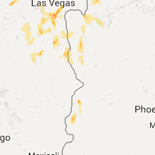
Nevada
| Local Time | Report Details |
|---|---|
| 2:13 PM PDT | Quarter sized hail reported near Las Vegas, NV, 10.1 miles SW of Las Vegas, NV, 1.0" hail at russell road and 215. |
| 2:30 PM PDT | Golf Ball sized hail reported near Las Vegas, NV, 9.7 miles SW of Las Vegas, NV, golf ball sized hail at buffalo and sunset. . |
| 2:35 PM PDT | Quarter sized hail reported near Las Vegas, NV, 8.3 miles SSW of Las Vegas, NV, nws employee report large hail at 215 and jones. |
| 2:37 PM PDT | Quarter sized hail reported near Las Vegas, NV, 8.3 miles SSW of Las Vegas, NV, quarter sized hail reported by public. |
| 2:38 PM PDT | Hen Egg sized hail reported near Las Vegas, NV, 8.3 miles SSW of Las Vegas, NV, 2" inch hail now falling ad 215 and jones. |
| 2:40 PM PDT | Quarter sized hail reported near Las Vegas, NV, 9.3 miles SSW of Las Vegas, NV, quarter sized hail reported by spotter. |
| 2:47 PM PDT | Quarter sized hail reported near Las Vegas, NV, 7.2 miles SSW of Las Vegas, NV, 1 inch hail and minor flooding reported by the public. |
| 3:00 PM PDT | Carport blown over at camden apartments. time estimated from radar. in clark county NV, 7.8 miles S of Las Vegas, NV |
| 3:08 PM PDT | Large mesquite tree blown down onto house. time estimated from rada in clark county NV, 9.7 miles SSE of Las Vegas, NV |
| 3:08 PM PDT | Half Dollar sized hail reported near Las Vegas, NV, 7.1 miles S of Las Vegas, NV, spotters reported half dollar sized hail and flooding on eastern and sunset. flooding was 1 foot deep... running and covering the sidewalks. . |
| 3:10 PM PDT | Quarter sized hail reported near Las Vegas, NV, 6.3 miles ESE of Las Vegas, NV, quarter sized hail reported by spotter. |
| 3:16 PM PDT | Fireworks stand destroyed by high winds near intersection of stephanie and sunset. time estimated from radar. in clark county NV, 9.2 miles SSE of Las Vegas, NV |
| 4:00 PM PDT | Hads automated station /clbn2 in clark county NV, 23.1 miles E of Las Vegas, NV |
| 5:15 PM PDT | Hads automated station /ccpn2 in clark county NV, 53.4 miles SSE of Las Vegas, NV |
| 6:01 PM MST | Trees down due to thunderstorm winds reported on north bound lane in bullhead city. in mohave county AZ, 47.1 miles NNW of Lake Havasu City, AZ |
| 6:05 PM MST | Report of travel traillers flipped over due to thunderstorm winds. in mohave county AZ, 47.1 miles NNW of Lake Havasu City, AZ |
| 11:44 PM PDT | Quarter sized hail reported near Pahrump, NV, 48.1 miles W of Las Vegas, NV, spotter in pahrump reported hail up to the size of a quarter. |
Kansas
| Local Time | Report Details |
|---|---|
| 4:19 PM CDT | Estimated 50-60 mph winds... with 4 inch diameter tree limbs down near the courthous in sumner county KS, 29 miles S of Wichita, KS |
| 4:32 PM CDT | Quarter sized hail reported near Wellington, KS, 29 miles S of Wichita, KS, public report on twitter of quarter hail in town. via kake tv. |
| 5:39 PM CDT | 60 to 65 mph winds and pea size hai in chautauqua county KS, 60.8 miles SW of Chanute, KS |
| 6:49 PM MDT | Golf Ball sized hail reported near Kanorado, KS, 53.4 miles WSW of Colby, KS, hailed for about 10 minutes. a lot of hail. largest size was golf ball. |
| 8:03 PM MDT | Storm damage reported in greeley county KS, 61.6 miles NW of Garden City, KS |
Texas
| Local Time | Report Details |
|---|---|
| 4:44 PM CDT | Wind gusts up to 60 mph reported with thunderstor in carson county TX, 41 miles E of Amarillo, TX |
Missouri
| Local Time | Report Details |
|---|---|
| 4:52 PM CDT | Power pole snapped in trenton. no other damage is reported and wind estimates were below 40 mph. the pole was reported to be in poor condition so winds were likely subs in grundy county MO, 84.8 miles NE of Kansas City, MO |
| 5:45 PM CDT | Severe thunderstorm wind gusts downed several tree limbs south of warsa in benton county MO, 69.2 miles N of Springfield, MO |
| 5:55 PM CDT | Quarter sized hail reported near Arbela, MO, 16.1 miles W of Kahoka, MO, relayed by nws st louis. |
| 6:00 PM CDT | A couple of trees down on hwy aa near roac in camden county MO, 59.3 miles NNE of Springfield, MO |
| 6:35 PM CDT | Quarter sized hail reported near Oronogo, MO, 63.8 miles ESE of Chanute, KS, report from social media. time estimated. |
| 6:35 PM CDT | Tree down near hwy 64 and meadowlark d in laclede county MO, 44.2 miles NE of Springfield, MO |
| 6:40 PM CDT | Tree down near hwys 64 and a in laclede county MO, 45.7 miles NE of Springfield, MO |
| 6:51 PM CDT | Several limbs down near chestnut and 65 near springfiel in greene county MO, 3.5 miles E of Springfield, MO |
| 6:55 PM CDT | Approx. 10-12 foot tree down near oakland ave. in bolivar. 6-9 inch tree split and laid over near 1117 aldrich rd in polk county MO, 28.4 miles NNW of Springfield, MO |
| 6:55 PM CDT | Approx. 10-12 foot tree down near oakland ave. in boliva in polk county MO, 28.5 miles NNW of Springfield, MO |
| 6:55 PM CDT | Approx. 10-12 foot tree down near oakland ave. in boliva in polk county MO, 28.5 miles NNW of Springfield, MO |
| 7:00 PM CDT | Tree branch fell and brought down power lin in saline county MO, 40.6 miles WNW of Columbia, MO |
| 7:05 PM CDT | Trees and a power pole down blocking a roa in jasper county MO, 57.9 miles W of Springfield, MO |
| 7:33 PM CDT | Large limbs and a couple of trees down east of sparta. time estimate in christian county MO, 19.6 miles SE of Springfield, MO |
Colorado
| Local Time | Report Details |
|---|---|
| 4:19 PM MDT | Pea size hail and 1.4 inches of rain in 20 minute in morgan county CO, 61.1 miles NE of Denver, CO |
| 6:14 PM MDT | Wind of 32 mph... gusting to 67 mp in lincoln county CO, 68.2 miles SW of Yuma, CO |
Oklahoma
| Local Time | Report Details |
|---|---|
| 7:10 PM CDT | Estimated 70mph wind gust at collinsville high school. time estimated by rada in tulsa county OK, 16.8 miles NNE of Tulsa, OK |
| 7:20 PM CDT | Quarter sized hail reported near Yukon, OK, 21.9 miles WNW of Oklahoma City, OK, hwy 3 |
| 7:20 PM CDT | Hwy 3 in canadian county OK, 21.9 miles WNW of Oklahoma City, OK |
| 7:22 PM CDT | Snapped pear tree in owass in tulsa county OK, 11.5 miles NE of Tulsa, OK |
| 11:10 PM CDT | Storm damage reported in woods county OK, 42.3 miles ENE of Woodward, OK |
Arizona
| Local Time | Report Details |
|---|---|
| 5:35 PM MST | Awos station bullhead city airport /ifp in mohave county AZ, 44.7 miles N of Lake Havasu City, AZ |
| 6:08 PM MST | Fox creek high school reported a peak gust to 61 mph. in mohave county AZ, 42.7 miles NNW of Lake Havasu City, AZ |
| 6:15 PM MST | Gust to 58 mph in bullhead city reported by a cwop statio in mohave county AZ, 45.7 miles NNW of Lake Havasu City, AZ |
Virginia
| Local Time | Report Details |
|---|---|
| 8:54 PM EDT | Quarter sized hail reported near Franklin, VA, 49.6 miles W of Virginia Beach, VA, 1 inch hail. |
| 9:38 PM EDT | Large limbs down on power lines. power outages reporte in city of franklin county VA, 48.1 miles W of Virginia Beach, VA |
North Carolina
| Local Time | Report Details |
|---|---|
| 9:20 PM EDT | One tree down blocking robinette roa in alexander county NC, 58.4 miles NNW of Charlotte, NC |
| 9:50 PM EDT | One large tree blocking alspaugh dam roa in alexander county NC, 50.4 miles NNW of Charlotte, NC |
| 1:20 AM EDT | One tree down on a local road in walnut cove which briefly blocked the road. time estimated from rada in stokes county NC, 68.6 miles S of Roanoke, VA |
| 1:53 AM EDT | Large tree down on a power line along west king highwa in rockingham county NC, 54.9 miles S of Roanoke, VA |
| 2:00 AM EDT | Tree down at the intersection of pannel road and settle bridge roa in rockingham county NC, 60.6 miles S of Roanoke, VA |
Connect with Interactive Hail Maps