

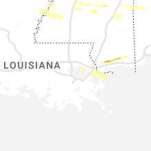
Hail Map for Sunday, March 12, 2023

Number of Impacted Households on 3/12/2023
0
Impacted by 1" or Larger Hail
0
Impacted by 1.75" or Larger Hail
0
Impacted by 2.5" or Larger Hail
Square Miles of Populated Area Impacted on 3/12/2023
0
Impacted by 1" or Larger Hail
0
Impacted by 1.75" or Larger Hail
0
Impacted by 2.5" or Larger Hail


Cities Most Affected by Hail Storms of 3/12/2023
| Hail Size | Demographics of Zip Codes Affected | ||||||
|---|---|---|---|---|---|---|---|
| City | Count | Average | Largest | Pop Density | House Value | Income | Age |
Hail and Wind Damage Spotted on 3/12/2023
Filter by Report Type:Hail ReportsWind Reports
Mississippi
| Local Time | Report Details |
|---|---|
| 7:24 AM CDT | Large tree across hwy 55 in jefferson county MS, 66.8 miles SW of Jackson, MS |
| 8:40 AM CDT | Tree blown down at e lincoln rd @ carmel-new hope r in lawrence county MS, 55 miles S of Jackson, MS |
| 8:40 AM CDT | Corrects previous tstm wnd dmg report from 3 e topeka. tree blown down on divide rd reported by e in lawrence county MS, 60.6 miles S of Jackson, MS |
| 8:50 AM CDT | Tree blown down on divide rd reported by e in lawrence county MS, 60.6 miles S of Jackson, MS |
| 5:07 PM CDT | Quarter sized hail reported near Quitman, MS, 84.5 miles W of Camden, AL, hail pictured next to a quarter along with a video of dime to quarter sized hail stones just south of quitman. |
| 9:25 PM CDT | Half Dollar sized hail reported near Kiln, MS, 55.3 miles NE of New Orleans, LA, pictures sent to wlox of hail around nickel to half dollar size covering the ground. possibly larger hail in photo. sent via social media. |
| 9:31 PM CDT | Ping Pong Ball sized hail reported near Pass Christian, MS, 58.1 miles NE of New Orleans, LA, multiple pictures sent via social media from wlox of hail around nickel to possibly ping pong size or larger along vidalia rd near necos. |
| 9:35 PM CDT | Quarter sized hail reported near Pass Christian, MS, 57.6 miles NE of New Orleans, LA, report from mping: quarter (1.00 in.) possibly larger as this was south of the core. |
Alabama
| Local Time | Report Details |
|---|---|
| 8:17 AM CDT | Wind damage involving utility poles down... trees down... roof shingles off... and sign damag in tallapoosa county AL, 32.5 miles NW of Auburn, AL |
| 8:52 AM CDT | Tree down near county road 11 and county road 3 in chambers county AL, 14.4 miles NNW of Auburn, AL |
| 9:13 AM CDT | Tree down on county road 29 in chambers county AL, 18.9 miles NE of Auburn, AL |
| 9:16 AM CDT | Trees down on interstate 85 near mm 7 in chambers county AL, 23.8 miles NE of Auburn, AL |
| 9:26 AM CDT | Multiple trees down in the city of lanett... some on homes... generally in the vicinity of cherry drive and 1st stree in chambers county AL, 24.4 miles NE of Auburn, AL |
| 10:19 AM CDT | Powerline down along highway 166 near the elementary school. location estimated. time stamp estimated via rada in coffee county AL, 73.5 miles NNE of Miramar Beach, FL |
| 10:38 AM CDT | Powerline down near cr15 and cr50. location estimated. time estimated via rada in dale county AL, 75.2 miles S of Auburn, AL |
| 12:02 PM CDT | Houston co 911 reports a tree down on waldo meadows rd near barnes r in houston county AL, 71.3 miles NW of Tallahassee, FL |
Georgia
| Local Time | Report Details |
|---|---|
| 12:15 PM EDT | Lee county 911 reports a tree down on pettis r in lee county GA, 85.9 miles WNW of Douglas, GA |
| 2:02 PM EDT | Tree down on stagecoach road. time estimated by rada in mitchell county GA, 58.9 miles N of Tallahassee, FL |
| 2:07 PM EDT | Trees down on railroad street. time estimated by rada in mitchell county GA, 46.8 miles N of Tallahassee, FL |
| 2:10 PM EDT | Mitchell co 911 reports a power line down on hwy 9 in mitchell county GA, 62.6 miles NNE of Tallahassee, FL |
| 2:12 PM EDT | Mitchell co 911 reports a tree down on glausier s in mitchell county GA, 48.2 miles N of Tallahassee, FL |
| 2:35 PM EDT | Colquitt co 911 reports a cable line down on talmadge d in colquitt county GA, 58.9 miles WSW of Douglas, GA |
| 2:50 PM EDT | Thomas co 911 reports a tree down across hwy 33 at woodhaven r in thomas county GA, 49.5 miles NE of Tallahassee, FL |
| 3:15 PM EDT | Awos station kbhc baxley mun in appling county GA, 30.3 miles ENE of Douglas, GA |
Florida
| Local Time | Report Details |
|---|---|
| 12:20 PM CDT | Trees down on highway 162 west of old us road. time estimated by rada in jackson county FL, 67.3 miles WNW of Tallahassee, FL |
| 1:09 PM CDT | Several trees and powerlines down near the intersection of gilberts mill road and kent road. time estimated by rada in washington county FL, 56.9 miles ENE of Miramar Beach, FL |
| 4:05 PM EDT | Jefferson co 911 reports a tree fell onto a power line on lake rd near simpson r in jefferson county FL, 25 miles ENE of Tallahassee, FL |
| 4:32 PM EDT | Quarter sized hail reported near Hosford, FL, 31.2 miles W of Tallahassee, FL, multiple reports of nickel to quarter-sized hail in hosford. hail was falling for about 4 minutes. |
| 5:30 PM EDT | Wakulla co 911 reports a tree fell onto a power line near iroquois r in wakulla county FL, 17.2 miles S of Tallahassee, FL |
| 8:30 PM EDT | Lafayette co 911 reports a tree on a power line on e us 27 near county road 41 in lafayette county FL, 78.3 miles ESE of Tallahassee, FL |
| 2:49 AM EDT | Asos station kgnv gainesvill in alachua county FL, 57.4 miles SW of Jacksonville, FL |
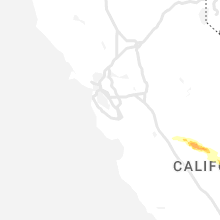
California
| Local Time | Report Details |
|---|---|
| 4:55 PM PDT | Quarter sized hail reported near Madera, CA, 34.3 miles WNW of Fresno, CA, nws employee reports inch-sized hail east of firebaugh. |
| 7:01 PM PDT | Chp reports e nebraska ave at s chestnut av in fresno county CA, 12.7 miles SSE of Fresno, CA |
| 7:01 PM PDT | Chp reports e nebraska ave at s chestnut av in fresno county CA, 12.7 miles SSE of Fresno, CA |
| 7:04 PM PDT | Chp reports tree down on e adams at s maple. thunderstorm win in fresno county CA, 7.9 miles SSE of Fresno, CA |
| 7:08 PM PDT | Chp reports tree down on w saginaw ave west of el in fresno county CA, 13.2 miles S of Fresno, CA |
| 7:11 PM PDT | Chp reports tree damaged car on e nebraska ave at s clovis av in fresno county CA, 13.3 miles SSE of Fresno, CA |
| 7:14 PM PDT | Chp reports tree crashed into house on s orange ave north of e dinuba av in fresno county CA, 10.5 miles S of Fresno, CA |
| 7:15 PM PDT | Chp reports power pole and lines down on s chestnut ave at e dinuba av in fresno county CA, 10.7 miles SSE of Fresno, CA |
| 7:16 PM PDT | Chp reports tree and power lines down on s fowler ave at e mountain view av in fresno county CA, 14.4 miles SSE of Fresno, CA |
| 7:22 PM PDT | Chp reports tree and power lines caught on fire at s clovis ave north of e floral av in fresno county CA, 12.1 miles SSE of Fresno, CA |
| 7:55 PM PDT | Chp reports flooding on highland ave at e dinuba av in fresno county CA, 13.5 miles SE of Fresno, CA |
| 7:58 PM PDT | Chp reports flooding on avenue 36 in tulare county CA, 30.2 miles SE of Fresno, CA |
| 8:31 PM PDT | Chp reports 30 foot tree in roadway on e saginaw ave west of temperanc in fresno county CA, 14.6 miles SSE of Fresno, CA |
| 8:57 PM PDT | Chp reports power pole broken in half and power lines on roadway on s fowler ave north of e kamm av in fresno county CA, 15.7 miles SSE of Fresno, CA |
New Mexico
| Local Time | Report Details |
|---|---|
| 7:23 PM MDT | Asos station kcqc clines corners 1 ss in torrance county NM, 55.8 miles E of Albuquerque, NM |
Connect with Interactive Hail Maps