

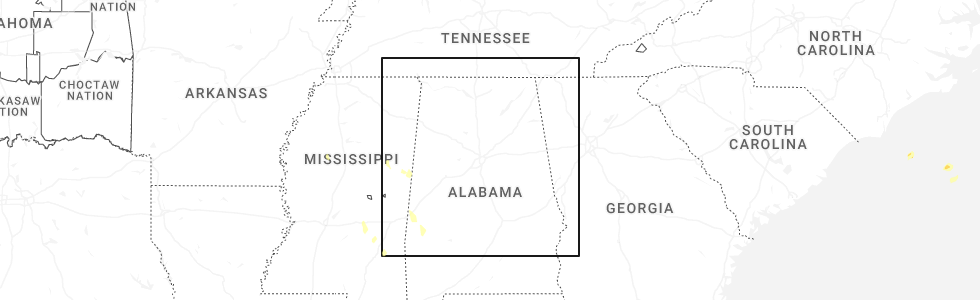
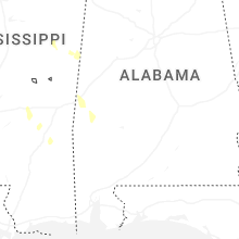
Hail Map for Sunday, May 11, 2025
Number of Impacted Households on 5/11/2025
0
Impacted by 1" or Larger Hail
0
Impacted by 1.75" or Larger Hail
0
Impacted by 2.5" or Larger Hail
Square Miles of Populated Area Impacted on 5/11/2025
0
Impacted by 1" or Larger Hail
0
Impacted by 1.75" or Larger Hail
0
Impacted by 2.5" or Larger Hail
Cities Most Affected by Hail Storms of 5/11/2025
| Hail Size | Demographics of Zip Codes Affected | ||||||
|---|---|---|---|---|---|---|---|
| City | Count | Average | Largest | Pop Density | House Value | Income | Age |
Hail and Wind Damage Spotted on 5/11/2025
Filter by Report Type:Hail ReportsWind Reports
States Impacted
Florida, Utah, Idaho, Georgia, Wyoming, Montana, Mississippi, North Dakota, South Dakota, South CarolinaFlorida
| Local Time | Report Details |
|---|---|
| 9:49 AM EDT | Fallen trees or limbs resulted in a power outage along obediah triplett roa in wakulla county FL, 20 miles S of Tallahassee, FL |
Utah
| Local Time | Report Details |
|---|---|
| 11:50 AM MDT | Mesonet station dpg24 w of wildca in tooele county UT, 85.9 miles WSW of Salt Lake City, UT |
| 12:00 PM MDT | Mesonet station dpg17 interstate 8 in tooele county UT, 83 miles W of Salt Lake City, UT |
| 12:00 PM MDT | Mesonet station utkno i-80 at mp 40 knoll in tooele county UT, 73.1 miles W of Salt Lake City, UT |
| 12:00 PM MDT | Semi roll over reported near mp 3 in tooele county UT, 76.2 miles W of Salt Lake City, UT |
| 12:10 PM MDT | Mesonet station utbig big mountain pas in salt lake county UT, 13.4 miles ENE of Salt Lake City, UT |
| 12:30 PM MDT | Mesonet station vrh vernon hil in tooele county UT, 50.6 miles SSW of Salt Lake City, UT |
| 12:45 PM MDT | Mesonet station lmr lakeside mountai in box elder county UT, 56.4 miles WNW of Salt Lake City, UT |
| 12:50 PM MDT | Mesonet station pc104 grantsville sout in tooele county UT, 34 miles WSW of Salt Lake City, UT |
| 12:50 PM MDT | Large tree down with root ball in grantsville. reported via social media pictur in tooele county UT, 32.5 miles WSW of Salt Lake City, UT |
| 1:00 PM MDT | Mesonet station uucmf uofu compass minerals flux towe in box elder county UT, 43.3 miles NNW of Salt Lake City, UT |
| 1:09 PM MDT | Mesonet station up068 mars in box elder county UT, 51.8 miles NW of Salt Lake City, UT |
| 1:10 PM MDT | Mesonet station ut9 lake point i-8 in tooele county UT, 20.1 miles WSW of Salt Lake City, UT |
| 1:10 PM MDT | Mesonet station pc490 kennecott rd lake poin in tooele county UT, 19.4 miles WSW of Salt Lake City, UT |
| 1:15 PM MDT | Mesonet station freut fremont island - miller hil in weber county UT, 35.5 miles NW of Salt Lake City, UT |
| 1:20 PM MDT | Mesonet station pc492 rada in box elder county UT, 45 miles NW of Salt Lake City, UT |
| 1:20 PM MDT | Mesonet station ut201 sr-201 at i-8 in tooele county UT, 18.2 miles W of Salt Lake City, UT |
| 1:30 PM MDT | Mesonet station ut33 i-80 at mp 2 in tooele county UT, 84.6 miles W of Salt Lake City, UT |
| 1:30 PM MDT | Mesonet station ut28 tremonto in box elder county UT, 65.8 miles NNW of Salt Lake City, UT |
| 1:32 PM MDT | Intense wind blowing trees... breaking tree parts... damaging household parts outsid in wasatch county UT, 34.7 miles ESE of Salt Lake City, UT |
| 1:37 PM MDT | Mesonet station ur305 27.0 e luci in box elder county UT, 87.6 miles WNW of Salt Lake City, UT |
| 1:48 PM MDT | Mesonet station as768 great salt lake marin in salt lake county UT, 17 miles W of Salt Lake City, UT |
| 1:50 PM MDT | Mesonet station uteur us-6 at eurek in utah county UT, 56.3 miles SSW of Salt Lake City, UT |
| 1:50 PM MDT | Mesonet station utedl i-80 at mp 71 east dell in tooele county UT, 45.8 miles W of Salt Lake City, UT |
| 1:56 PM MDT | Mesonet station fw8325 garden cit in rich county UT, 85.5 miles NNE of Salt Lake City, UT |
| 2:00 PM MDT | Mesonet station ew2533 bountiful benc in davis county UT, 9.9 miles NNE of Salt Lake City, UT |
| 2:10 PM MDT | Mesonet station utkno i-80 at mp 40 knoll in tooele county UT, 73.1 miles W of Salt Lake City, UT |
| 2:17 PM MDT | Large trees down. reported with pictures via social medi in cache county UT, 74.6 miles N of Salt Lake City, UT |
| 2:29 PM MDT | Mesonet station ur434 strns in box elder county UT, 66.9 miles WNW of Salt Lake City, UT |
| 2:40 PM MDT | Mesonet station utkno i-80 at mp 40 knoll in tooele county UT, 73.1 miles W of Salt Lake City, UT |
| 2:50 PM MDT | Mesonet station utkno i-80 at mp 40 knoll in tooele county UT, 73.1 miles W of Salt Lake City, UT |
| 2:55 PM MDT | Mesonet station kcc02 marin in salt lake county UT, 16.5 miles W of Salt Lake City, UT |
| 2:58 PM MDT | Wind gust of 75 for 20-30 second in box elder county UT, 89.9 miles WNW of Salt Lake City, UT |
| 3:00 PM MDT | Mesonet station pc104 grantsville sout in tooele county UT, 34 miles WSW of Salt Lake City, UT |
| 3:00 PM MDT | Mesonet station sbt15 snowbasin - strawberry tower 1 in morgan county UT, 29.7 miles N of Salt Lake City, UT |
| 3:00 PM MDT | Mesonet station ut201 sr-201 at i-8 in tooele county UT, 18.2 miles W of Salt Lake City, UT |
| 3:10 PM MDT | Mesonet station pc490 kennecott rd lake poin in tooele county UT, 19.4 miles WSW of Salt Lake City, UT |
| 3:10 PM MDT | Mesonet station utkno i-80 at mp 40 knoll in tooele county UT, 73.1 miles W of Salt Lake City, UT |
| 3:12 PM MDT | Mesonet station as768 great salt lake marin in salt lake county UT, 17 miles W of Salt Lake City, UT |
| 3:25 PM MDT | Mesonet station dpg14 wig mountai in tooele county UT, 68.8 miles WSW of Salt Lake City, UT |
| 3:35 PM MDT | Awos station ktvy bolinder field-tooele valley airpor in tooele county UT, 26.1 miles WSW of Salt Lake City, UT |
| 3:40 PM MDT | Mesonet station pc490 kennecott rd lake poin in tooele county UT, 19.4 miles WSW of Salt Lake City, UT |
| 5:20 PM MDT | Mesonet station utgrs i-80 at grasse in tooele county UT, 58.9 miles W of Salt Lake City, UT |
| 6:00 PM MDT | Mesonet station utgrs i-80 at grasse in tooele county UT, 58.9 miles W of Salt Lake City, UT |
| 6:03 PM MDT | Pacificorp site pc49 in box elder county UT, 45.3 miles NW of Salt Lake City, UT |
| 6:10 PM MDT | Mesonet station pc123 murray's hil in cache county UT, 58.8 miles N of Salt Lake City, UT |
| 6:20 PM MDT | Mesonet station utwdl i-80 at mp 68 west dell in tooele county UT, 47.9 miles W of Salt Lake City, UT |
| 7:00 PM MDT | Recorded at the u of u compass minerals flux tower site. microburst associated with a high based showe in box elder county UT, 43.3 miles NNW of Salt Lake City, UT |
| 7:00 PM MDT | Mesonet station utedl i-80 at mp 71 east dell in tooele county UT, 45.8 miles W of Salt Lake City, UT |
| 7:15 PM MDT | Mesonet station gslm great salt lake mineral in weber county UT, 42.3 miles NNW of Salt Lake City, UT |
| 7:30 PM MDT | Mesonet station wjdnb west jordan benc in salt lake county UT, 14.6 miles SW of Salt Lake City, UT |
| 7:30 PM MDT | Mesonet station utdwy sr-85 at dannon wa in salt lake county UT, 14.5 miles SSW of Salt Lake City, UT |
| 7:35 PM MDT | Recorded at the south valley regional airpor in salt lake county UT, 11 miles SSW of Salt Lake City, UT |
| 7:40 PM MDT | Mesonet station utckh chaulk hil in box elder county UT, 87.8 miles NNW of Salt Lake City, UT |
| 8:30 PM MDT | Mesonet station utusu us-89 at us in cache county UT, 67.8 miles N of Salt Lake City, UT |
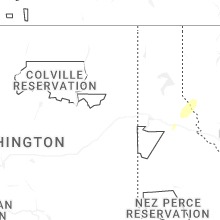
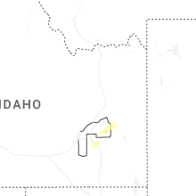
Idaho
| Local Time | Report Details |
|---|---|
| 12:15 PM MDT | Mesonet station 2983 d4 conner summit id-7 in cassia county ID, 50.6 miles ESE of Twin Falls, ID |
| 12:40 PM MDT | Mesonet station 690 inl central facilitie in butte county ID, 45.7 miles W of Idaho Falls, ID |
| 1:45 PM MDT | Mesonet station 3251 d4 - hansen bridg in jerome county ID, 8.7 miles E of Twin Falls, ID |
| 1:51 PM MDT | Quarter sized hail reported near Inkom, ID, 49.4 miles SSW of Idaho Falls, ID, photo and video submitted of estimated quarter size hail falling just west of inkom. time estimated based on radar. |
| 1:54 PM MDT | Measured near the intersection of id-77 and narrows r in cassia county ID, 53.8 miles ESE of Twin Falls, ID |
| 1:58 PM MDT | Asos station ktwf twin fall in twin falls county ID, 5.3 miles S of Twin Falls, ID |
| 2:02 PM MDT | Mesonet station tt087 saylor cree in owyhee county ID, 59.3 miles WNW of Twin Falls, ID |
| 2:30 PM MDT | Mesonet station pc506 sheep creek hill in bear lake county ID, 91 miles SSE of Idaho Falls, ID |
| 2:55 PM MDT | Measured along id-34 near blackfoot river r in caribou county ID, 52.6 miles SSE of Idaho Falls, ID |
| 3:00 PM MDT | Mesonet station sldmt 9.8 nw soldier (uunet in camas county ID, 65 miles E of Boise, ID |
| 3:01 PM MDT | Quarter sized hail reported near Swan Valley, ID, 36.5 miles E of Idaho Falls, ID, via facebook. time estimated by radar. |
| 3:09 PM MDT | Estimated 60-70 mph winds over pine creek pass. time estimated based on rada in bonneville county ID, 41.6 miles E of Idaho Falls, ID |
| 3:14 PM MDT | Several trees down in the game creek area off of old jackson highway. time estimated based on rada in teton county ID, 49.2 miles E of Idaho Falls, ID |
| 3:15 PM MDT | Mesonet station itde5 d6 palisades dam us-2 in bonneville county ID, 43.8 miles ESE of Idaho Falls, ID |
| 3:15 PM MDT | Mbwbt mount bair in bonneville county ID, 48.1 miles E of Idaho Falls, ID |
| 3:43 PM MDT | Mesonet station hpfi1 horton pea in custer county ID, 75.5 miles ENE of Boise, ID |
| 3:44 PM MDT | Asos station kpih pocatello regional airpor in power county ID, 47.6 miles SW of Idaho Falls, ID |
| 3:50 PM MDT | Asos station kllj challis airpor in custer county ID, 48 miles SSW of Salmon, ID |
| 4:40 PM MDT | Pc371 medicine lodg in clark county ID, 61.3 miles NNW of Idaho Falls, ID |
| 4:45 PM MDT | Mesonet station tgfi1 trail gulc in twin falls county ID, 18.6 miles SSE of Twin Falls, ID |
| 5:00 PM MDT | 3699 inl puzzle us-20/us-2 in butte county ID, 42.6 miles W of Idaho Falls, ID |
| 5:00 PM MDT | Mesonet station pbf inl critical infrastructur in butte county ID, 41.8 miles W of Idaho Falls, ID |
| 5:10 PM MDT | Mesonet station ebr inl materials fuels comple in bingham county ID, 31.3 miles WNW of Idaho Falls, ID |
| 5:25 PM MDT | Mesonet station ro in jefferson county ID, 29.1 miles WNW of Idaho Falls, ID |
| 5:35 PM MDT | Mesonet station te in jefferson county ID, 30.6 miles NW of Idaho Falls, ID |
| 5:45 PM MDT | 2979 botts id-3 in teton county ID, 43.4 miles NE of Idaho Falls, ID |
| 5:50 PM MDT | Mesonet station ha in jefferson county ID, 37.1 miles NNW of Idaho Falls, ID |
| 5:30 PM PDT | Quarter sized hail reported near Pinehurst, ID, 55.5 miles E of Spokane, WA |
| 7:00 PM MDT | A 2 to 3 foot diameter tree uproote in bonneville county ID, 10.6 miles NNE of Idaho Falls, ID |
| 7:00 PM MDT | Several trees uprooted at rigby pioneer cemetery. time of event estimated based on rada in jefferson county ID, 14.2 miles NNE of Idaho Falls, ID |
Georgia
| Local Time | Report Details |
|---|---|
| 2:20 PM EDT | Report from emergency manager of a mobile home knocked off its foundation in west broxton. time estimated via rada in coffee county GA, 9.1 miles NNW of Douglas, GA |
Wyoming
| Local Time | Report Details |
|---|---|
| 12:30 PM MDT | Mesonet station pc450 evanston nort in uinta county WY, 65.8 miles NE of Salt Lake City, UT |
| 1:23 PM MDT | Awos station kdub dubois airpor in fremont county WY, 74.9 miles WNW of Riverton, WY |
| 2:42 PM MDT | Mesonet station gcrw4 meeteetse 10 in hot springs county WY, 64.2 miles NNW of Riverton, WY |
| 3:10 PM MDT | Mesonet station pc450 evanston nort in uinta county WY, 65.8 miles NE of Salt Lake City, UT |
| 3:36 PM MDT | Awos station kjac jackson hole airpor in teton county WY, 66.4 miles E of Idaho Falls, ID |
| 4:52 PM MDT | Mesonet station wy42 farson (wydot in sweetwater county WY, 38 miles NNW of Rock Springs, WY |
| 5:20 PM MDT | Mesonet station pc395 shoshone southfor in park county WY, 103.4 miles NNW of Riverton, WY |
| 5:20 PM MDT | Mesonet station pc462 irma lak in park county WY, 102.6 miles NNW of Riverton, WY |
| 5:26 PM MDT | Mesonet station krec red canyon - south pas in fremont county WY, 30.3 miles SSW of Riverton, WY |
| 5:30 PM MDT | Mesonet station pc261 cedar mountai in park county WY, 94.1 miles SSW of Billings, MT |
| 5:30 PM MDT | Mesonet station pc462 irma lak in park county WY, 102.6 miles NNW of Riverton, WY |
| 6:15 PM MDT | Awos station kpoy powell airpor in park county WY, 64.7 miles SSW of Billings, MT |
| 7:19 PM MDT | Storm damage reported in crook county WY, 50.8 miles NNE of Gillette, WY |
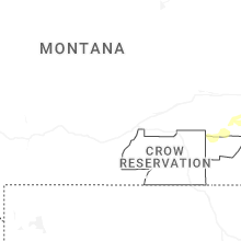
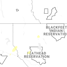
Montana
| Local Time | Report Details |
|---|---|
| 2:00 PM MDT | Storm damage reported in stillwater county MT, 42.5 miles WSW of Billings, MT |
| 2:53 PM MDT | 68 mph gust measured at nws great falls. (corrected from non-tstm gust to tstm gust) in cascade county MT, 5.1 miles SW of Great Falls, MT |
| 3:05 PM MDT | 58 mph gust at ambiient weather station. (corrected from non-tstm gust to tstm gust) in cascade county MT, 6.4 miles N of Great Falls, MT |
| 3:06 PM MDT | 63 mph gust at ambient weather station. (corrected from non-tstm gust to tstm gust) in cascade county MT, 7.4 miles NNW of Great Falls, MT |
| 3:07 PM MDT | 59 mph gust at ambient weather station. (corrected from non-tstm gust to tstm gust) in cascade county MT, 1.7 miles NNW of Great Falls, MT |
| 3:20 PM MDT | Corrects previous non-tstm wnd dmg report from 2 sw great falls to tstm wnd dmg. large conifer tree snapped and down on cherry dr in fox farm are in cascade county MT, 2.2 miles SSW of Great Falls, MT |
| 4:55 PM MDT | Montana mesonet station big sandy s in chouteau county MT, 39.9 miles SSW of Havre, MT |
| 6:01 PM MDT | Mesonet station bafm8 badger pea in rosebud county MT, 60.9 miles SSW of Miles City, MT |
| 6:15 PM MDT | Mesonet station mthcd home creek divide us-212 mp 81. in powder river county MT, 59.2 miles S of Miles City, MT |
| 7:29 PM MDT | Mesonet station hbom8 hillsbor in carbon county MT, 49.2 miles SSE of Billings, MT |
| 11:55 PM MDT | Ping Pong Ball sized hail reported near Plains, MT, 60.4 miles SSW of Whitefish, MT, reported lots of hail ranging in size from pea size to golf balls. |
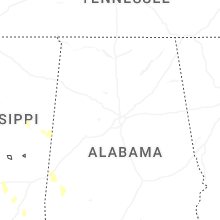
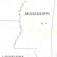
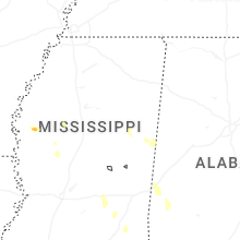
Mississippi
| Local Time | Report Details |
|---|---|
| 4:50 PM CDT | 2-2.5 foot diameter elm tree snapped and fell on the roof of a house causing mostly exterior damage. no hail nor rain was occurring during the time of the tree snapping in oktibbeha county MS, 0.3 miles NNE of Starkville, MS |
North Dakota
| Local Time | Report Details |
|---|---|
| 6:03 PM MDT | 4n bowman ndawn. reading at 10 meter in bowman county ND, 118.2 miles E of Miles City, MT |
| 8:23 PM MDT | Hettinger nw (ndawn). 10 meter wind gust of 68 mph at the same tim in adams county ND, 104.1 miles WSW of Bismarck, ND |
| 8:28 PM MDT | Asos station khei hettinger airpor in adams county ND, 104.6 miles WSW of Bismarck, ND |
| 9:10 PM MDT | New leipzig ess nd dot sit in grant county ND, 65.9 miles WSW of Bismarck, ND |
| 9:11 PM MDT | Mesonet station tt584 12 e mot in hettinger county ND, 68.3 miles WSW of Bismarck, ND |
| 9:55 PM MDT | Elgin 10nw (ndawn). 10 meter wind gus in grant county ND, 61.3 miles WSW of Bismarck, ND |
South Dakota
| Local Time | Report Details |
|---|---|
| 6:20 PM MDT | Storm damage reported in meade county SD, 66.7 miles NNE of Rapid City, SD |
South Carolina
| Local Time | Report Details |
|---|---|
| 3:20 AM EDT | Corrects previous tstm wnd dmg report from 1 ne burnettown. langley fire department reports their station has 2 bay doors ripped off. time estimated from rada in aiken county SC, 8.3 miles ENE of Augusta, GA |
| 3:28 AM EDT | Scdps reports a tree down near intersection of parker dr and old cherokee dr west of langle in aiken county SC, 4.6 miles ENE of Augusta, GA |
| 3:33 AM EDT | Scdps reports a tree across sudlow lake rd north of augusta... g in aiken county SC, 6.7 miles NE of Augusta, GA |
Connect with Interactive Hail Maps