

Hail Map for Wednesday, May 24, 2017

Number of Impacted Households on 5/24/2017
0
Impacted by 1" or Larger Hail
0
Impacted by 1.75" or Larger Hail
0
Impacted by 2.5" or Larger Hail
Square Miles of Populated Area Impacted on 5/24/2017
0
Impacted by 1" or Larger Hail
0
Impacted by 1.75" or Larger Hail
0
Impacted by 2.5" or Larger Hail


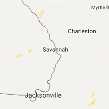


Cities Most Affected by Hail Storms of 5/24/2017
| Hail Size | Demographics of Zip Codes Affected | ||||||
|---|---|---|---|---|---|---|---|
| City | Count | Average | Largest | Pop Density | House Value | Income | Age |
| Burkesville, KY | 1 | 1.75 | 1.75 | 20 | $50k | $22.0k | 43.9 |
Hail and Wind Damage Spotted on 5/24/2017
Filter by Report Type:Hail ReportsWind Reports
States Impacted
Alabama, Georgia, Florida, Tennessee, Kentucky, Virginia, South Carolina, North Carolina, Montana, Nevada, Utah, OhioAlabama
| Local Time | Report Details |
|---|---|
| 7:55 AM CDT | Several trees uprooted across eastern blount county. wind speeds estimated at 40-50 mp in blount county AL, 35.5 miles NNE of Birmingham, AL |
| 8:15 AM CDT | Large trees limbs (>2") downed. wind speeds estimated at 40-50 mp in etowah county AL, 57.2 miles NE of Birmingham, AL |
| 8:35 AM CDT | Tree down near at intersection of county road 36 and county road 70. estimated 40-50 mph winds. time estimated by rada in cherokee county AL, 63.8 miles SSW of Chattanooga, TN |
| 8:38 AM CDT | Tree down near sand rock school. estimated 40-50 mph winds. time estimated by rada in cherokee county AL, 61.5 miles SSW of Chattanooga, TN |
Georgia
| Local Time | Report Details |
|---|---|
| 9:44 AM EDT | Trees down and a car spun around on cleveland hwy near pleasent hill dr...could be associated with a possible tornado in whitfield county GA, 25.7 miles SE of Chattanooga, TN |
| 10:20 AM EDT | Tree down at the intersection of little sand mountain road and haywood valley roa in chattooga county GA, 41 miles S of Chattanooga, TN |
| 10:55 AM EDT | 911 call center in murray co reports a tree down near the intersection of hwy 225 and henry gallman rd in murray county GA, 38.1 miles SE of Chattanooga, TN |
| 10:55 AM EDT | Home reported to be damaged at the intersection of ga-136 and dover roa in gordon county GA, 38.9 miles SE of Chattanooga, TN |
| 10:58 AM EDT | Murray co 911 call center reports a tree blown down near the intersection of cagle rd and mashburn rd in murray county GA, 39.4 miles SE of Chattanooga, TN |
| 11:15 AM EDT | Trees reported down at the intersection of ga-411 and pack roa in gordon county GA, 46.4 miles SE of Chattanooga, TN |
| 11:37 AM EDT | Report of a tree blown down on sunrock mt rd near tennis ct rd in fannin county GA, 53.7 miles E of Chattanooga, TN |
| 11:43 AM EDT | Report of a tree blown down on loving rd near ga 515 in fannin county GA, 62.8 miles E of Chattanooga, TN |
| 2:08 PM EDT | Damage to barn roofs and several trees reported down near the intersection of valambrosia road and moore station roa in laurens county GA, 70.4 miles N of Douglas, GA |
| 2:16 PM EDT | Multiple trees down on washington road at keg creek driv in columbia county GA, 22.3 miles WNW of Augusta, GA |
| 3:12 PM EDT | Tree reported down near shining light baptist church on trackrock gap roa in union county GA, 73.3 miles W of Greenville, SC |
| 4:54 PM EDT | Backyard items including a trampoline were blown approximately 200 fee in cook county GA, 38 miles SW of Douglas, GA |
| 5:02 PM EDT | One tree down on lucile stree in berrien county GA, 32.1 miles SW of Douglas, GA |
| 5:02 PM EDT | One tree down on shane circl in berrien county GA, 33 miles SW of Douglas, GA |
| 11:02 PM EDT | A tree down with multiple power lines along mcgregor alston roa in montgomery county GA, 46.9 miles NNE of Douglas, GA |
| 11:12 PM EDT | Multiple trees and powerlines near meadows regional medical center. also streetlights are down along highway 280 near the hospita in toombs county GA, 55.8 miles NNE of Douglas, GA |
| 11:13 PM EDT | Flagpole bent in half at brantleys marine and gun in toombs county GA, 56.1 miles NNE of Douglas, GA |
| 11:15 PM EDT | Multiple trees and power lines down near the walmart supercente in toombs county GA, 55.8 miles NNE of Douglas, GA |
| 11:23 PM EDT | A tree down with multiple power lines along mcgregor alston roa in montgomery county GA, 46.9 miles NNE of Douglas, GA |
| 11:28 PM EDT | Candler county dispatch reported a tree down on eden church roa in candler county GA, 66.3 miles WNW of Savannah, GA |
| 12:14 AM EDT | A tree was reported down and across the road on old register way near the intersection with sinkhole road. report was received over the bulloch county police...fire...a in bulloch county GA, 46.9 miles WNW of Savannah, GA |
| 12:37 AM EDT | Multiple trees and power lines down just west of buckhorn cree in montgomery county GA, 48.1 miles NNE of Douglas, GA |
Florida
| Local Time | Report Details |
|---|---|
| 9:53 AM EDT | Fallen trees or limbs resulted in a power outage on the east side of monticello in jefferson county FL, 26.6 miles ENE of Tallahassee, FL |
| 10:54 AM EDT | Fallen trees or limbs resulted in a power outage on the southeast side of may in lafayette county FL, 71.6 miles ESE of Tallahassee, FL |
| 12:23 PM EDT | Law enforcement reported numerous trees down across levy county. time estimated by rada in levy county FL, 87.1 miles SW of Jacksonville, FL |
| 1:48 PM EDT | Peak wind gust at mesonet in clearwte in gmz853 county FL, 36.8 miles NNW of Bradenton, FL |
| 2:15 PM EDT | A metal flat roof peeled back over a lanai. no damage to nearby trees. winds estimated 50 mp in polk county FL, 37.6 miles SW of Orlando, FL |
| 2:31 PM EDT | Media relayed electric company report of powerlines down on scenic drive. time estimated from rada in clay county FL, 21.5 miles SW of Jacksonville, FL |
| 2:47 PM EDT | Ham radio operator reported large tree down in the oneco are in manatee county FL, 4.3 miles SE of Bradenton, FL |
| 2:48 PM EDT | Emergency manager reported a large tree fell on a house causing minor damage on the 2200 block of 57th east in bradento in manatee county FL, 5.5 miles E of Bradenton, FL |
| 2:55 PM EDT | A small but intense thunderstorm produced sporadic wind damage over northwest orange county. several trees and large branches were reported downed by wekiwa springs sta in orange county FL, 12.9 miles NNW of Orlando, FL |
| 3:05 PM EDT | Emergency manager reported multiple trees down on the corner of north parsons ave and windhorst roa in hillsborough county FL, 36.5 miles NNE of Bradenton, FL |
| 3:47 PM EDT | An intense thunderstorm moved northeast along i-4 in central orange county and produced several reports of minor wind damage in and around the city of orlando. a gas st in orange county FL, 3.2 miles SW of Orlando, FL |
| 4:40 PM EDT | Usaf wind tower 0421 reported peak wind gust of 51 kt from the west. nearby usaf tower 0022 reported peak gust of 52 kt at 450p in brevard county FL, 38.8 miles ENE of Orlando, FL |
| 7:58 PM EDT | A thunderstorm produced a wind gust of 61 mph at cypress bay high school in broward county FL, 25.6 miles NNW of Miami, FL |
| 8:06 PM EDT | An off duty nws employee reported a tree down due to wind gusts from a thunderstor in broward county FL, 24 miles NNW of Miami, FL |
Tennessee
| Local Time | Report Details |
|---|---|
| 10:05 AM EDT | Six trees dow in bradley county TN, 32.4 miles E of Chattanooga, TN |
| 11:54 AM EDT | Numerous trees down in the middle creek are in sevier county TN, 22.5 miles ESE of Knoxville, TN |
| 11:54 AM EDT | Several trees down in the great smoky mountains national park. trees reported down in the treemont...laurel creek...and the little river between elkmont and laurel fall in sevier county TN, 29.3 miles SE of Knoxville, TN |
| 12:15 PM EDT | Several trees as well as power lines down on a house in the bogard communit in cocke county TN, 36.3 miles E of Knoxville, TN |
| 12:18 PM EDT | Trees down in cosby and along interstate 40 at exit 44 in cocke county TN, 39 miles ESE of Knoxville, TN |
| 12:18 PM EDT | Numerous trees down in the edwina are in cocke county TN, 43.3 miles E of Knoxville, TN |
| 12:30 PM EDT | Few trees down along the western edge of the count in greene county TN, 52.5 miles E of Knoxville, TN |
| 12:40 PM EDT | Few trees down along the western portions of the county...east of caney branc in greene county TN, 52.5 miles E of Knoxville, TN |
| 1:20 PM EDT | Significant damage to the poplar ridge apartments along hwy 36. multiple trees and power lines down... along with roof and fence damag in washington county TN, 17.5 miles SW of Bristol, TN |
Kentucky
| Local Time | Report Details |
|---|---|
| 1:24 PM EDT | Tree down in pike county KY, 65.9 miles NNW of Bristol, TN |
| 1:10 PM CDT | Golf Ball sized hail reported near Burkesville, KY, 82.6 miles ENE of Nashville, TN |
| 1:10 PM CDT | Trees reported dow in cumberland county KY, 84.8 miles SSE of Louisville, KY |
| 2:25 PM EDT | Tree dow in pike county KY, 60.9 miles NNW of Bristol, TN |
| 3:33 PM EDT | Quarter sized hail reported near Nancy, KY, 64.1 miles SW of Irvine, KY, quarter size hail reported from faubush eastward to nancy |
| 3:44 PM EDT | Roof damage to barn and several trees blown down on the propert in pulaski county KY, 51.2 miles SW of Irvine, KY |
| 4:13 PM EDT | Main street in brodhead has powerlines down and several trees are blown down in the are in rockcastle county KY, 32 miles SW of Irvine, KY |
| 4:14 PM EDT | Quarter sized hail reported near Brodhead, KY, 32 miles SW of Irvine, KY |
| 4:20 PM EDT | Quarter sized hail reported near Brodhead, KY, 29.5 miles SW of Irvine, KY |
Virginia
| Local Time | Report Details |
|---|---|
| 1:40 PM EDT | Trees down on highway 2 in scott county VA, 14.4 miles WNW of Bristol, TN |
| 1:51 PM EDT | Numerous trees and power lines down across the city of bristol... va. some structural damage to roofs of a few building in city of bristol county VA, 3.1 miles ENE of Bristol, TN |
| 1:53 PM EDT | Trees down at washington-lee elementary school. trees and power lines down on lee highway near valley driv in city of bristol county VA, 3.1 miles ENE of Bristol, TN |
| 2:10 PM EDT | Over a dozen trees down across the city of abingdon including a large tree down on a house on summerwood driv in washington county VA, 16.2 miles ENE of Bristol, TN |
| 2:44 PM EDT | Numerous large limbs down and power out. time from rada in smyth county VA, 39.9 miles NE of Bristol, TN |
| 2:55 PM EDT | One tree down near the intersection of route 16 and route 610 in smyth county VA, 45.2 miles ENE of Bristol, TN |
| 3:00 PM EDT | One tree down that took down power lines on blackhorse road in tazewell county VA, 53.8 miles NE of Bristol, TN |
| 5:51 PM EDT | One tree down on heidelbach school road in patrick county VA, 33.7 miles SSW of Roanoke, VA |
| 6:04 PM EDT | One tree down near the intersection of saddleridge road and microfilm road in patrick county VA, 36.9 miles SSW of Roanoke, VA |
| 6:22 PM EDT | One tree down near the intersection of old quarry road and daniels creek road in henry county VA, 32.6 miles S of Roanoke, VA |
| 6:25 PM EDT | One tree down near the intersection of henry road and providence church road in franklin county VA, 29.8 miles S of Roanoke, VA |
| 6:33 PM EDT | One tree down on muse field road close to route 220 in franklin county VA, 18.4 miles SSE of Roanoke, VA |
| 6:49 PM EDT | One tree down on lovely valley road close to the intersection with scruggs road in franklin county VA, 18.6 miles SE of Roanoke, VA |
| 7:03 PM EDT | One tree down near the intersection of eton road and deep woods road in franklin county VA, 10.9 miles SE of Roanoke, VA |
South Carolina
| Local Time | Report Details |
|---|---|
| 2:47 PM EDT | Tree on house at 511 johnston highwa in saluda county SC, 37.1 miles NNE of Augusta, GA |
| 2:49 PM EDT | Multiple trees down on medical park roa in saluda county SC, 40.3 miles NNE of Augusta, GA |
| 2:52 PM EDT | 60 mph winds estimated west of salud in saluda county SC, 36.2 miles NNE of Augusta, GA |
| 3:30 PM EDT | Trees in roadway 330 long pine roa in lexington county SC, 56.3 miles NE of Augusta, GA |
| 3:38 PM EDT | Multiple trees/power lines down and several houses damaged in vicinity of pomaria/garmany elementary schoo in newberry county SC, 63.2 miles NNE of Augusta, GA |
| 3:57 PM EDT | Trees down at long pine road and strawfield road. time estimated from rada in lexington county SC, 56.1 miles NE of Augusta, GA |
| 4:04 PM EDT | Tree in roadway at koon road and wes bickley roa in richland county SC, 64.2 miles NE of Augusta, GA |
| 4:13 PM EDT | Trees in roadway monroe highway and capricorn roa in lancaster county SC, 29.6 miles S of Charlotte, NC |
| 4:19 PM EDT | Trees in roadway camp creek and george carnes roa in lancaster county SC, 31.5 miles SSE of Charlotte, NC |
| 4:57 PM EDT | Trees down at long pine road and strawfield road. time estimated from rada in lexington county SC, 56.1 miles NE of Augusta, GA |
| 11:12 PM EDT | Trees down at cherokee drive and apache drive in clearwater. time estimated from rada in aiken county SC, 4.3 miles ENE of Augusta, GA |
| 11:16 PM EDT | Trees down blocking both lanes of hampton ave. in aike in aiken county SC, 15.5 miles ENE of Augusta, GA |
| 11:44 PM EDT | Quarter sized hail reported near Batesburg, SC, 34.8 miles NE of Augusta, GA, public report of quarter size hail holder rd. |
North Carolina
| Local Time | Report Details |
|---|---|
| 3:20 PM EDT | Trees and powerlines down at ostwalt amity rd and triplett r in iredell county NC, 33.1 miles N of Charlotte, NC |
| 3:20 PM EDT | Trees down on old glenwood rd in the glenwood communit in mcdowell county NC, 65 miles NNE of Greenville, SC |
| 3:44 PM EDT | Homes damaged and numerous trees down at hunters ridge rd and hwy 64. funnel cloud reported in the area. possible tornado damag in iredell county NC, 40.6 miles N of Charlotte, NC |
| 3:45 PM EDT | Fire department reported numerous trees down and damage to a home on swann rd. mentioned possible tornad in iredell county NC, 42.1 miles N of Charlotte, NC |
| 4:04 PM EDT | Large tree down in s. charlotte. time estimated from rada in mecklenburg county NC, 1.8 miles SSE of Charlotte, NC |
| 4:10 PM EDT | Trees down at montford cove rd. and hensley r in mcdowell county NC, 58.8 miles NNE of Greenville, SC |
| 4:14 PM EDT | Numerous trees down and structural damage to homes on four corners rd. off hwy 801. possible tornado damag in davie county NC, 57.8 miles NNE of Charlotte, NC |
| 4:20 PM EDT | Shingles torn off homes and numerous trees uprooted on s rocky river rd. trees down on multiple homes. possible tornado damag in union county NC, 30.1 miles SSE of Charlotte, NC |
| 4:25 PM EDT | Numerous trees down and truck damaged. possible tornado damag in union county NC, 27.8 miles SSE of Charlotte, NC |
| 4:25 PM EDT | Numerous trees down and truck damaged. possible tornado damag in union county NC, 27.8 miles SSE of Charlotte, NC |
| 4:25 PM EDT | Outbuildings damaged on clarksville campground rd. possible tornado damag in union county NC, 28.1 miles SSE of Charlotte, NC |
| 4:30 PM EDT | Trees down and shingles removed from home on joe collins rd in union county NC, 27.6 miles SE of Charlotte, NC |
| 4:30 PM EDT | Trees down on homes and uprooted on austin rd. possible tornado damag in union county NC, 27.2 miles SE of Charlotte, NC |
| 4:30 PM EDT | Numerous trees and power lines down in the 5200 block of plyler mill rd. roof damage to homes and outbuildings. possible tornado damag in union county NC, 28.1 miles SSE of Charlotte, NC |
| 4:33 PM EDT | 1800 block of hamptonville road four trees were blown down...trees were blocking the roa in yadkin county NC, 60.6 miles N of Charlotte, NC |
| 4:45 PM EDT | Trees down across county in anson county NC, 38 miles ESE of Charlotte, NC |
| 4:54 PM EDT | Several trees down near the intersection of trinity church road and nauvoo ridge drive in stokes county NC, 72.7 miles SSW of Roanoke, VA |
| 5:00 PM EDT | Trees snapped off and debris on both sides of highway 52 just south of pilot mountain state park. possible tornado based on radar signature in stokes county NC, 72.1 miles SSW of Roanoke, VA |
| 5:05 PM EDT | Large limb across dowd road in west end in moore county NC, 61.1 miles WSW of Raleigh, NC |
| 5:10 PM EDT | Some damage to mobile homes in trailer park along ymca camp rd. possible tornado according to radar signature in stokes county NC, 67 miles SSW of Roanoke, VA |
| 5:11 PM EDT | Numerous trees were blown down within a 300 yard wide area near intersection of tayler road and route 66. in the same area...a roof was damaged and a barn was blown dow in stokes county NC, 64.5 miles SSW of Roanoke, VA |
| 1:49 AM EDT | Trees and power lines down in the cit in anson county NC, 46.8 miles ESE of Charlotte, NC |
| 1:52 AM EDT | Trees and power lines down on n. green stree in anson county NC, 47.1 miles ESE of Charlotte, NC |
| 1:53 AM EDT | Trees down on stanback ferry r in anson county NC, 47.6 miles ESE of Charlotte, NC |
| 2:10 AM EDT | Tree down on john webb rd.... near the intersection of sandy ridge church r in richmond county NC, 61.3 miles ESE of Charlotte, NC |
Montana
| Local Time | Report Details |
|---|---|
| 2:53 PM MDT | Storm damage reported in custer county MT, 2.5 miles NW of Miles City, MT |
Nevada
| Local Time | Report Details |
|---|---|
| 3:56 PM PDT | Thunderstorm outflow gust to 58 mp in nye county NV, 144.2 miles SW of Ely, NV |
Utah
| Local Time | Report Details |
|---|---|
| 5:30 PM MDT | Storm damage reported in tooele county UT, 76.8 miles WSW of Salt Lake City, UT |
| 5:56 PM MDT | Storm damage reported in tooele county UT, 91 miles E of Elko, NV |
| 6:00 PM MDT | Storm damage reported in tooele county UT, 93.4 miles E of Elko, NV |
| 6:10 PM MDT | Storm damage reported in tooele county UT, 84.6 miles W of Salt Lake City, UT |
| 6:20 PM MDT | Storm damage reported in tooele county UT, 38.4 miles W of Salt Lake City, UT |
| 7:00 PM MDT | Storm damage reported in tooele county UT, 80.1 miles NE of Ely, NV |
| 7:00 PM MDT | Storm damage reported in salt lake county UT, 12.7 miles W of Salt Lake City, UT |
| 7:25 PM MDT | Storm damage reported in weber county UT, 35.5 miles NW of Salt Lake City, UT |
| 7:30 PM MDT | Storm damage reported in tooele county UT, 18.2 miles W of Salt Lake City, UT |
| 7:35 PM MDT | Storm damage reported in tooele county UT, 80.2 miles SW of Salt Lake City, UT |
Ohio
| Local Time | Report Details |
|---|---|
| 8:00 PM EDT | Tree on hous in lawrence county OH, 58 miles WNW of Charleston, WV |
| 8:01 PM EDT | Tree on hous in lawrence county OH, 57.6 miles WNW of Charleston, WV |
| 8:08 PM EDT | Large tree down at the lawrence county... ohio court hous in lawrence county OH, 58 miles WNW of Charleston, WV |
| 8:08 PM EDT | Large tree down at the lawrence county... ohio court hous in lawrence county OH, 58 miles WNW of Charleston, WV |
| 8:08 PM EDT | Tree on hous in lawrence county OH, 57.6 miles WNW of Charleston, WV |
| 8:28 PM EDT | Several trees and powerlines down near intersection of dayton xenia rd and trebein rd. time estimated by radar. possible tornad in greene county OH, 49.9 miles NNE of Cincinnati, OH |
| 8:53 PM EDT | Several trees down along a portion of dayton yellowsprings rd near fairborn. time estimated by radar. possible tornad in greene county OH, 54.1 miles NNE of Cincinnati, OH |
| 9:13 PM EDT | Damage observed at a sunoco gas station just south of styer drive. nearby roof damage at grocery store. time estimated by radar. possible tornad in clark county OH, 55.8 miles W of Columbus, OH |
| 9:19 PM EDT | Trees and powerlines down along bellefontaine rd. between us 40 and palmer road. time estimated by radar. possible tornad in miami county OH, 55.8 miles W of Columbus, OH |
| 9:28 PM EDT | Two homes reported with some structural damage. time estimated by radar. possible tornad in miami county OH, 57.2 miles W of Columbus, OH |
| 10:09 PM EDT | Trees and powerlines reported down near intersection of deweese rd. and peterson rd. time estimated by radar. possible tornad in miami county OH, 62.6 miles W of Columbus, OH |
Connect with Interactive Hail Maps