

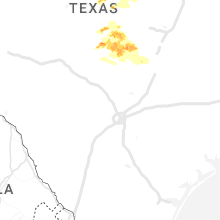
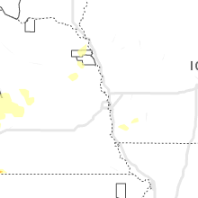
Hail Map for Friday, May 5, 2023

Number of Impacted Households on 5/5/2023
0
Impacted by 1" or Larger Hail
0
Impacted by 1.75" or Larger Hail
0
Impacted by 2.5" or Larger Hail
Square Miles of Populated Area Impacted on 5/5/2023
0
Impacted by 1" or Larger Hail
0
Impacted by 1.75" or Larger Hail
0
Impacted by 2.5" or Larger Hail


Cities Most Affected by Hail Storms of 5/5/2023
| Hail Size | Demographics of Zip Codes Affected | ||||||
|---|---|---|---|---|---|---|---|
| City | Count | Average | Largest | Pop Density | House Value | Income | Age |
| Burnet, TX | 5 | 2.15 | 2.50 | 45 | $80k | $37.9k | 43.1 |
| Muenster, TX | 2 | 2.00 | 2.25 | 11 | $80k | $43.9k | 39.5 |
| Bloomington, NE | 2 | 1.75 | 1.75 | 3 | $26k | $20.6k | 50.0 |
| Franklin, NE | 1 | 2.50 | 2.50 | 11 | $36k | $28.6k | 48.5 |
| Burkett, TX | 1 | 2.00 | 2.00 | 1 | $27k | $22.4k | 54.4 |
| Edison, NE | 1 | 2.00 | 2.00 | 1 | $31k | $33.6k | 45.3 |
| Bertrand, NE | 1 | 1.75 | 1.75 | 7 | $63k | $37.1k | 45.2 |
| Arapahoe, NE | 1 | 1.75 | 1.75 | 6 | $45k | $29.4k | 46.4 |
| Imperial, NE | 1 | 1.75 | 1.75 | 2 | $67k | $34.4k | 41.3 |
| Cozad, NE | 1 | 1.75 | 1.75 | 23 | $61k | $34.0k | 40.3 |
| Comanche, TX | 1 | 1.75 | 1.75 | 16 | $45k | $29.4k | 43.0 |
| Hayes Center, NE | 1 | 1.75 | 1.75 | 1 | $34k | $26.9k | 47.0 |
| Holbrook, NE | 1 | 1.75 | 1.75 | 2 | $20k | $25.9k | 45.4 |
Hail and Wind Damage Spotted on 5/5/2023
Filter by Report Type:Hail ReportsWind Reports
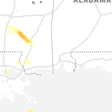
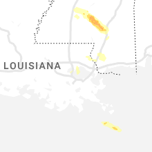
Mississippi
| Local Time | Report Details |
|---|---|
| 12:52 PM CDT | Several trees down near raymond r in hinds county MS, 5.4 miles WSW of Jackson, MS |
| 1:22 PM CDT | Several trees down near/in the gallman are in copiah county MS, 28.2 miles SSW of Jackson, MS |
| 1:31 PM CDT | Tree down on house on cola lane. trees down across i-55 in hazlehurs in copiah county MS, 32.6 miles SSW of Jackson, MS |
| 1:31 PM CDT | Reports of multiple trees down near lilly r in copiah county MS, 30.7 miles SSW of Jackson, MS |
| 1:31 PM CDT | Reports of a few trees down near may l in copiah county MS, 30.9 miles SSW of Jackson, MS |
| 1:40 PM CDT | Public reports several trees along with a few powerlines down near jackson st... a few miles north of hwy 2 in copiah county MS, 31.4 miles SSW of Jackson, MS |
| 1:41 PM CDT | Reports of multiple trees down near shreby lane north of hwy 2 in copiah county MS, 30.7 miles SSW of Jackson, MS |
| 1:45 PM CDT | Tree down across poplar springs r in copiah county MS, 35.2 miles S of Jackson, MS |
| 1:45 PM CDT | Reports of multiple trees and powerlines down near rockport r in copiah county MS, 36.6 miles S of Jackson, MS |
| 1:45 PM CDT | Reports of multiple trees down near steel creek r in copiah county MS, 32.3 miles S of Jackson, MS |
| 1:48 PM CDT | Public reports of multiple trees down near hwy 51 near south wesso in copiah county MS, 43.2 miles SSW of Jackson, MS |
| 1:48 PM CDT | Public reports of a few trees and powerlines down near great southern r in copiah county MS, 33.2 miles SSW of Jackson, MS |
| 1:51 PM CDT | Reports of multiple trees down near hwy 5 in copiah county MS, 39.9 miles SSW of Jackson, MS |
| 1:51 PM CDT | Multiple trees down near poplar springs r in copiah county MS, 34.6 miles S of Jackson, MS |
| 1:54 PM CDT | Reports of several trees and powerlines down near jackson ave right outside georgetow in copiah county MS, 29.5 miles S of Jackson, MS |
| 2:13 PM CDT | Reports of several trees down near nelson r in franklin county MS, 68 miles SW of Jackson, MS |
| 2:13 PM CDT | Trees down on hwy 42 and 4 in lawrence county MS, 38.6 miles SSE of Jackson, MS |
| 2:15 PM CDT | Trees down and damage to a cafeteria... more damage exists... but details to come late in lawrence county MS, 40.9 miles SSE of Jackson, MS |
| 2:15 PM CDT | Quarter sized hail reported near Newhebron, MS, 40.9 miles SSE of Jackson, MS |
| 2:17 PM CDT | Trees dow in jefferson davis county MS, 50.5 miles SSE of Jackson, MS |
| 2:20 PM CDT | Multiple trees down across the nw part of the count in jefferson davis county MS, 42.1 miles SSE of Jackson, MS |
| 2:59 PM CDT | Tree down at n bryant and rocky branch r in lamar county MS, 71.3 miles SSE of Jackson, MS |
| 2:59 PM CDT | Trees down across hwy 58 in covington county MS, 70.5 miles SSE of Jackson, MS |
| 2:59 PM CDT | Quarter sized hail reported near Sumrall, MS, 71.3 miles SSE of Jackson, MS, photographs show ground covering hail in sumrall. the majority of the hail was small... but some stones reached one inch in diameter. |
| 3:00 PM CDT | Tree down in town... 3 homes damaged from this tre in marion county MS, 74.6 miles SSE of Jackson, MS |
| 3:03 PM CDT | Emergency management reported minor structural damage to a house along with several trees down near blackjack r in covington county MS, 53.4 miles SSE of Jackson, MS |
| 3:06 PM CDT | Emergency management reported structural damage to a house near ridge rd along with several trees dow in covington county MS, 63.1 miles SE of Jackson, MS |
| 3:15 PM CDT | Multiple trees dow in lamar county MS, 80.4 miles SE of Jackson, MS |
| 3:19 PM CDT | Emergency management reported numerous trees and powerlines down near partman cemetery in nw jefferson davis count in jefferson davis county MS, 45.1 miles SSE of Jackson, MS |
| 3:22 PM CDT | Reports of multiple trees down near mitchell hudson r in forrest county MS, 76 miles SE of Jackson, MS |
| 3:23 PM CDT | Trees down on epley r in lamar county MS, 74.6 miles SSE of Jackson, MS |
| 3:36 PM CDT | Emergency management reported multiple trees down all across forrest count in forrest county MS, 78.8 miles WNW of Mobile, AL |
| 3:36 PM CDT | Pictures from social media via twitter show a tree down on a home near king rd in hattiesbur in lamar county MS, 80.4 miles SE of Jackson, MS |
| 3:41 PM CDT | Emergency management reported multiple trees down across covington county. a tree fell on a car due to the strong thunderstorm winds... however no injuries were reporte in lamar county MS, 87.5 miles WNW of Mobile, AL |
| 3:52 PM CDT | Tree reported down blocking the highway on ms highway 13 at landrum cemetery road in pearl river county. time estimated by rada in pearl river county MS, 82.1 miles NNE of New Orleans, LA |
| 4:17 PM CDT | Emergency management reported structural damage to a luxury inn outside hattiesbur in forrest county MS, 82 miles SE of Jackson, MS |
Texas
| Local Time | Report Details |
|---|---|
| 4:15 PM CDT | Hen Egg sized hail reported near Burkett, TX, 32.2 miles SE of Abilene, TX |
| 4:15 PM CDT | Quarter sized hail reported near Bridgeport, TX, 63.8 miles WNW of Dallas, TX |
| 4:26 PM CDT | Quarter sized hail reported near Brownwood, TX, 70.7 miles SE of Abilene, TX |
| 4:30 PM CDT | 4 inch tree limbs down along fm 145 in wise county TX, 58.7 miles WNW of Dallas, TX |
| 4:32 PM CDT | 4 inch tree limbs down along fm 145 in wise county TX, 60.1 miles SE of Wichita Falls, TX |
| 4:32 PM CDT | 4 inch tree limbs down along fm 145 in wise county TX, 60.1 miles SE of Wichita Falls, TX |
| 4:40 PM CDT | Half Dollar sized hail reported near Alvord, TX, 59.7 miles SE of Wichita Falls, TX |
| 4:40 PM CDT | Half Dollar sized hail reported near Era, TX, 58.9 miles NNW of Dallas, TX |
| 5:03 PM CDT | Half Dollar sized hail reported near San Saba, TX, 64.2 miles W of Killeen, TX |
| 5:17 PM CDT | Golf Ball sized hail reported near Comanche, TX, 73 miles ESE of Abilene, TX, report from mping: golf ball (1.75 in.). |
| 5:26 PM CDT | Ping Pong Ball sized hail reported near Muenster, TX, 66.7 miles ESE of Wichita Falls, TX, report from mping: ping pong ball (1.50 in.). |
| 5:32 PM CDT | Golf Ball sized hail reported near Muenster, TX, 67.5 miles ESE of Wichita Falls, TX, report from mping: golf ball (1.75 in.). |
| 5:34 PM CDT | Hen Egg sized hail reported near Muenster, TX, 67.5 miles ESE of Wichita Falls, TX, report from mping. |
| 6:19 PM CDT | Quarter sized hail reported near Burnet, TX, 42.9 miles WSW of Killeen, TX |
| 6:32 PM CDT | Ping Pong Ball sized hail reported near Burnet, TX, 41 miles SW of Killeen, TX, video of ping pong size hail near the intersection of hwy 29 and rr 2341. time estimated via radar. |
| 6:35 PM CDT | Tennis Ball sized hail reported near Burnet, TX, 42.5 miles SW of Killeen, TX, cracked windshield on vehicle. |
| 6:44 PM CDT | Golf Ball sized hail reported near Burnet, TX, 38.7 miles SW of Killeen, TX |
| 6:50 PM CDT | Quarter sized hail reported near Burnet, TX, 36.9 miles SW of Killeen, TX, report from mping quarter (1.00 in). |
| 6:56 PM CDT | Hen Egg sized hail reported near Burnet, TX, 36.5 miles SW of Killeen, TX |
| 6:58 PM CDT | Hen Egg sized hail reported near Burnet, TX, 36.5 miles SW of Killeen, TX, egg size hail reported on hwy 29 near the brandenburg plumbing business to the east of burnet. |
| 7:05 PM CDT | Tennis Ball sized hail reported near Burnet, TX, 39.6 miles SW of Killeen, TX, social media picture of hail measured up to near tennis ball size near the burnet municipal airport with rough time estimate of 7:05 pm. |
| 7:10 PM CDT | Quarter sized hail reported near Hico, TX, 64.7 miles NNW of Killeen, TX |
| 7:10 PM CDT | Quarter sized hail reported near Burnet, TX, 44.5 miles WSW of Killeen, TX, intersection of fm 690 and peninsula drive. time estimated. |
| 7:30 PM CDT | Ping Pong Ball sized hail reported near Valley Spring, TX, 71 miles WSW of Killeen, TX, time estimated via radar. |
| 8:07 PM CDT | Quarter sized hail reported near Llano, TX, 62 miles WSW of Killeen, TX |
| 8:15 PM CDT | Storm damage reported in llano county TX, 59.8 miles WSW of Killeen, TX |
| 8:25 PM CDT | Half Dollar sized hail reported near Llano, TX, 61.4 miles WSW of Killeen, TX |
| 8:42 PM CDT | Reports of down power pole and several transformers out near kingsland. time estimated via rada in llano county TX, 53.2 miles SW of Killeen, TX |
| 8:45 PM CDT | Quarter sized hail reported near Buchanan Dam, TX, 50.8 miles WSW of Killeen, TX, report from mping quarter. |
| 8:50 PM CDT | Trees and power poles down from sandy mountain to sunrise beach. time estimated via rada in llano county TX, 55.3 miles SW of Killeen, TX |
| 8:55 PM CDT | Reports of down power pole and several transformers out near sunrise beach. time estimated via rada in llano county TX, 54 miles SW of Killeen, TX |
| 8:56 PM CDT | Downed trees near the intersection of fm 1431 and phillips ranch rd; 1100 people without power in granite shoals. time estimated via rada in burnet county TX, 51.8 miles SW of Killeen, TX |
| 8:56 PM CDT | Quarter sized hail reported near Llano, TX, 58.5 miles SW of Killeen, TX, report from mping quarter. |
| 8:56 PM CDT | Report from mping 3-inch tree limbs broken... power poles broke in burnet county TX, 52.3 miles SW of Killeen, TX |
| 8:59 PM CDT | Quarter sized hail reported near Llano, TX, 58.6 miles SW of Killeen, TX, report from mping quarter. |
| 9:02 PM CDT | Quarter sized hail reported near Bertram, TX, 33.6 miles SW of Killeen, TX |
| 9:11 PM CDT | Half Dollar sized hail reported near Marble Falls, TX, 48.6 miles SW of Killeen, TX, report from mping half dollar. |
| 9:25 PM CDT | Quarter sized hail reported near Marble Falls, TX, 48.6 miles SW of Killeen, TX, mostly dime and nickel size with quarter size mixed in. |
| 10:02 PM CDT | 64 mph measured at aprswxnet/cwop station fw7040 in lago vist in travis county TX, 50.7 miles SSW of Killeen, TX |
| 10:10 PM CDT | Quarter sized hail reported near Leander, TX, 47.2 miles SSW of Killeen, TX |
| 10:16 PM CDT | T35 (cameron) awos 40g52k in milam county TX, 47.8 miles ESE of Killeen, TX |
| 10:18 PM CDT | Quarter sized hail reported near Leander, TX, 46.8 miles SSW of Killeen, TX, report from mping quarter. |
| 10:25 PM CDT | Quarter sized hail reported near Llano, TX, 75.2 miles SW of Killeen, TX |
| 10:47 PM CDT | Estimated winds of 50 to 60 mph at fm 1460 and westinghouse r in williamson county TX, 36.5 miles S of Killeen, TX |
| 11:30 PM CDT | Weatherstem station at kyle fiel in brazos county TX, 82.4 miles NW of Houston, TX |
| 11:32 PM CDT | Nearly 1800 customers reported without power due to thunderstorms in robertson and brazos countie in brazos county TX, 83 miles ESE of Killeen, TX |
| 11:53 PM CDT | Delayed report: kact asos reported 50 knot wind gus in mclennan county TX, 44.9 miles NE of Killeen, TX |
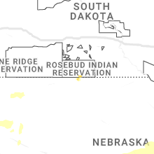
Nebraska
| Local Time | Report Details |
|---|---|
| 5:22 PM CDT | Half Dollar sized hail reported near Republican City, NE, 72.9 miles SW of Grand Island, NE |
| 5:25 PM CDT | Quarter sized hail reported near Republican City, NE, 75.8 miles SW of Grand Island, NE |
| 5:47 PM CDT | Quarter sized hail reported near Naponee, NE, 70.2 miles SW of Grand Island, NE, via mping. |
| 5:55 PM CDT | Golf Ball sized hail reported near Bloomington, NE, 66.6 miles SSW of Grand Island, NE, it hailed for at least 30 mins starting around 530 pm but was mostly up to nickel size. largest hail up to golf ball started around 555 and lasted 10 mins. |
| 6:04 PM CDT | Golf Ball sized hail reported near Bloomington, NE, 67.2 miles SSW of Grand Island, NE |
| 6:12 PM CDT | Half Dollar sized hail reported near Franklin, NE, 65.3 miles SSW of Grand Island, NE, hail up to half dollar size reported by county dispatch. |
| 6:14 PM CDT | Tennis Ball sized hail reported near Franklin, NE, 65.3 miles SSW of Grand Island, NE, ongoing on the north side of franklin. |
| 6:53 PM CDT | Quarter sized hail reported near Riverton, NE, 61.7 miles SSW of Grand Island, NE |
| 5:59 PM MDT | Storm damage reported in box butte county NE, 45.2 miles ENE of Scottsbluff, NE |
| 7:07 PM CDT | Golf Ball sized hail reported near Holbrook, NE, 64.5 miles SE of North Platte, NE, quarter to golf ball size hail reported 13ne of cambridge. |
| 6:15 PM MDT | Imperial asos reports wind gust of 63 mp in chase county NE, 61.9 miles SW of North Platte, NE |
| 7:40 PM CDT | Half Dollar sized hail reported near Republican City, NE, 69.8 miles SW of Grand Island, NE, pea to half dollar size hail was reported about 1e of huntley. |
| 7:40 PM CDT | Golf Ball sized hail reported near Arapahoe, NE, 70.1 miles SE of North Platte, NE |
| 7:52 PM CDT | Hen Egg sized hail reported near Edison, NE, 71.4 miles SE of North Platte, NE, delayed report of hail a little larger than golf ball size. time estimated from radar. |
| 6:55 PM MDT | Golf Ball sized hail reported near Imperial, NE, 60.6 miles SW of North Platte, NE, trained spotter report of golf ball sized hail in between imperial and enders on hwy 6. |
| 6:56 PM MDT | Ping Pong Ball sized hail reported near Imperial, NE, 58.5 miles SW of North Platte, NE, spotter network report of ping pong sized hail 4 miles n of enders. |
| 7:00 PM MDT | Personal weather station report of 74 mph wind gust 2 s of lama in chase county NE, 48.4 miles NE of Yuma, CO |
| 7:02 PM MDT | Quarter sized hail reported near Madrid, NE, 46.2 miles WSW of North Platte, NE, public report of mostly pea sized hail with some quarter sized hail mixed in. |
| 8:10 PM CDT | Golf Ball sized hail reported near Bertrand, NE, 72.7 miles SE of North Platte, NE, hail up to size of golf balls started around 810 pm...lasted about 20 mins. |
| 7:35 PM MDT | Imperial asos report of 60 mph gus in chase county NE, 61.9 miles SW of North Platte, NE |
| 8:44 PM CDT | Personal weather station report of 62 mph wind gust 1 nnw of sutherlan in lincoln county NE, 19.8 miles W of North Platte, NE |
| 8:44 PM CDT | Quarter sized hail reported near Cozad, NE, 45.2 miles ESE of North Platte, NE, corrects previous hail report of 1.75 inches from cozad. |
| 8:44 PM CDT | Golf Ball sized hail reported near Cozad, NE, 45.2 miles ESE of North Platte, NE |
| 9:00 PM CDT | Mesonet 3n of hayes center reports 84 mph wind gus in hayes county NE, 42.8 miles SSW of North Platte, NE |
| 9:04 PM CDT | Personal weather station reports wind gust of 70 mp in lincoln county NE, 2.1 miles WNW of North Platte, NE |
| 9:15 PM CDT | Golf Ball sized hail reported near Hayes Center, NE, 45.1 miles SSW of North Platte, NE, spotter drove through hayes center and noticed golf ball sized hail along the roadway. |
| 10:00 PM CDT | Mesonet 3 n of hayes center reports 60 mph wind gus in hayes county NE, 42.8 miles SSW of North Platte, NE |
| 10:04 PM CDT | Quarter sized hail reported near Axtell, NE, 44.2 miles WSW of Grand Island, NE, video of quarter size hail south of kearney from twitter. exact location estimated from radar. |
| 10:12 PM CDT | Quarter sized hail reported near Kearney, NE, 43 miles WSW of Grand Island, NE, report from mping: quarter (1.00 in.). |
| 10:14 PM CDT | Quarter sized hail reported near Kearney, NE, 42.3 miles WSW of Grand Island, NE, from spotter network. |
| 10:19 PM CDT | Quarter sized hail reported near Kearney, NE, 41.3 miles WSW of Grand Island, NE |
| 10:23 PM CDT | Half Dollar sized hail reported near Kearney, NE, 41.3 miles WSW of Grand Island, NE |
| 10:56 PM CDT | Storm damage reported in gosper county NE, 59.2 miles SE of North Platte, NE |
| 10:56 PM CDT | Facebook photos... garage door blown in... fence blown down... shed collapse in dawson county NE, 54.8 miles ESE of North Platte, NE |
| 11:09 PM CDT | Storm damage reported in custer county NE, 61.4 miles ENE of North Platte, NE |
| 11:10 PM CDT | Public report of lost power at johnson lake. tree branch of unknown size was downed. a couple of docks were flipped. time estimated based on rada in gosper county NE, 57.2 miles ESE of North Platte, NE |
| 11:10 PM CDT | Public report of lost power at johnson lake. tree branch of unknown size was downed. a couple of docks were flipped. time estimated based on rada in gosper county NE, 57.2 miles ESE of North Platte, NE |
| 11:15 PM CDT | Storm damage reported in dawson county NE, 57.2 miles ESE of North Platte, NE |
| 11:24 PM CDT | Storm damage reported in custer county NE, 61.4 miles ENE of North Platte, NE |
| 11:24 PM CDT | Storm damage reported in dawson county NE, 62.5 miles W of Grand Island, NE |
| 11:37 PM CDT | Storm damage reported in phelps county NE, 59.5 miles WSW of Grand Island, NE |
| 12:06 AM CDT | Collapsible flag pole taken down... em guesses 45-50 mph win in sherman county NE, 41 miles NW of Grand Island, NE |
| 12:08 AM CDT | Quarter sized hail reported near Elm Creek, NE, 56.9 miles WSW of Grand Island, NE, report of quarter size hail relayed via emergency manager. |
| 12:11 AM CDT | Home weather station in garfield county NE, 52.9 miles SSW of Oneill, NE |
| 12:12 AM CDT | Storm damage reported in sherman county NE, 38.7 miles NW of Grand Island, NE |
| 12:21 AM CDT | Storm damage reported in sherman county NE, 40.5 miles NW of Grand Island, NE |
| 12:28 AM CDT | Quarter sized hail reported near Kearney, NE, 40.6 miles WSW of Grand Island, NE |
Colorado
| Local Time | Report Details |
|---|---|
| 6:36 PM MDT | Mesonet station co048 us 385 holyok in phillips county CO, 33 miles NE of Yuma, CO |
| 6:39 PM MDT | Spotter reported outflow winds from thunderstorm to the north. measured sustained winds at 63 mph with gusts to 70 mp in phillips county CO, 38.9 miles NE of Yuma, CO |
| 6:53 PM MDT | Storm damage reported in phillips county CO, 42.3 miles NE of Yuma, CO |
Connect with Interactive Hail Maps