

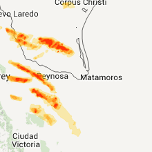
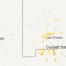
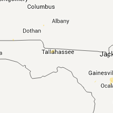
Hail Map for Tuesday, May 8, 2012

Number of Impacted Households on 5/8/2012
0
Impacted by 1" or Larger Hail
0
Impacted by 1.75" or Larger Hail
0
Impacted by 2.5" or Larger Hail
Square Miles of Populated Area Impacted on 5/8/2012
0
Impacted by 1" or Larger Hail
0
Impacted by 1.75" or Larger Hail
0
Impacted by 2.5" or Larger Hail


Cities Most Affected by Hail Storms of 5/8/2012
| Hail Size | Demographics of Zip Codes Affected | ||||||
|---|---|---|---|---|---|---|---|
| City | Count | Average | Largest | Pop Density | House Value | Income | Age |
| Caballo, NM | 1 | 1.75 | 1.75 | 4 | $85k | $27.7k | 57.8 |
Hail and Wind Damage Spotted on 5/8/2012
Filter by Report Type:Hail ReportsWind Reports
Texas
| Local Time | Report Details |
|---|---|
| 12:00 PM CDT | Zapata county emergency manager reports thunderstorm wind gusts of 60 to 65 mph occurred in san ygnaci in zapata county TX, 34.6 miles S of Laredo, TX |
| 12:00 PM CDT | Three to four homes with roof damage in san ygnacio as well as one mobile home destroye in zapata county TX, 34.6 miles S of Laredo, TX |
| 12:35 PM CDT | Storm damage reported in zapata county TX, 46.6 miles SSE of Laredo, TX |
| 12:38 PM CDT | Three to four homes with roof damage in san ygnacio as well as one mobile home destroye in zapata county TX, 33.4 miles S of Laredo, TX |
| 1:03 PM CDT | Several trees down around 4 inches in diameter at 4th and flores streets in zapat in zapata county TX, 46.6 miles SSE of Laredo, TX |
| 1:56 PM CDT | Telephone poles snapped along with trees down in orange grove. also poles and trees down near orange grove high schoo in jim wells county TX, 34.4 miles WNW of Corpus Christi, TX |
| 1:56 PM CDT | Nws survey concluded that a downburst of straight-line occurred just south of orange grove near intersection of hwy 359 and cr 374. winds were estimated at 70-80 mph. d in jim wells county TX, 34.5 miles WNW of Corpus Christi, TX |
| 2:19 PM CDT | 20 ft tall well secured tv antenna blown dow in nueces county TX, 27.7 miles WNW of Corpus Christi, TX |
| 2:22 PM CDT | Trees down at west lake subdivisio in nueces county TX, 23.5 miles WNW of Corpus Christi, TX |
| 2:52 PM CDT | Quarter sized hail reported near Corpus Christi, TX, 16.3 miles WNW of Corpus Christi, TX |
| 3:23 PM CDT | Quarter sized hail reported near Zapata, TX, 46.6 miles SSE of Laredo, TX, quarter size hail reported at lincoln and 5th street. |
| 3:26 PM CDT | Wind gusts estimated 60 to 65 mph at lincoln and 5th stree in zapata county TX, 46.6 miles SSE of Laredo, TX |
| 5:10 PM CDT | *** 1 inj *** semi trailer blown over on us 281 6 miles north of tx hwy 18 in hidalgo county TX, 64.8 miles NW of Brownsville, TX |
| 5:10 PM CDT | Constable reported home lost numerous shigles... one window blown out... large mesquite and ebony tree branches snapped in hidalgo county TX, 65.1 miles NW of Brownsville, TX |
| 6:05 PM CDT | Willacy county emergency manager reports 50 to 60 mph winds occurred in raymondvill in willacy county TX, 43.7 miles NNW of Brownsville, TX |
Florida
| Local Time | Report Details |
|---|---|
| 2:05 PM EDT | A wind gust of 59 kts...or 68 mph...was reported by a mesonet site at sun life stadium. this mesonet site is located on top of the stadium...at an esimated height of ab in miami-dade county FL, 15.2 miles N of Miami, FL |
| 2:45 PM EDT | Media reported several tree branches were snapped and two light poles were bent/knocked down...near the intersection of indian creek parkway and maplewood drive. damage in palm beach county FL, 28.7 miles SE of Port Saint Lucie, FL |
| 7:05 PM EDT | A convenient store along u.s. highway 315 reported that there were numerous tree limbs down. the time given was based on rada in marion county FL, 59.3 miles SSW of Jacksonville, FL |
| 7:25 PM EDT | The interlachen fire department reported wind gusts estimated at 50 to 60 mph. the time given was based on rada in putnam county FL, 51 miles SSW of Jacksonville, FL |
Alabama
| Local Time | Report Details |
|---|---|
| 1:15 PM CDT | A couple trees and power lines down near intersection of cr 209 and cr 21 in coffee county AL, 76.8 miles SSW of Auburn, AL |
| 8:30 PM CDT | Tree down at martin rd and union chapel rd. winds estimated at 40 to 50 mp in tuscaloosa county AL, 45.8 miles WSW of Birmingham, AL |
| 8:30 PM CDT | Tree down at the 3900 block of mcgee rd. winds estimated at 40 to 50 mp in tuscaloosa county AL, 44.4 miles WSW of Birmingham, AL |
New Mexico
| Local Time | Report Details |
|---|---|
| 1:50 PM MDT | Golf Ball sized hail reported near Caballo, NM, 58 miles ENE of Silver City, NM |
Mississippi
| Local Time | Report Details |
|---|---|
| 3:55 PM CDT | Trees were blown down along two county roads near the county border in carroll county MS, 60.3 miles W of Starkville, MS |
| 4:15 PM CDT | Half Dollar sized hail reported near Winona, MS, 51.7 miles W of Starkville, MS, quarter to half dollar size hail south of duck hill |
Connect with Interactive Hail Maps